A Korean version of this map page is available. View Korean Page
A Taichung City Map is helpful when a simple marker on a Taiwan map is not enough. Taichung City is located in central-western Taiwan, between the island’s northern and southern urban regions. It connects with Miaoli County to the north, Changhua County and Nantou County to the south, and the mountain areas of central Taiwan to the east. Toward the west, the city reaches coastal and port-related areas near the Taiwan Strait. Because of this mix of compact urban districts, coastal communities, industrial zones, and wide mountain-side areas, district boundaries make the city much easier to understand.
This printable Taichung City Map collection includes three versions: a color district map, a black and white labeled map, and a blank outline map. The files are prepared in JPG format and designed for A3-size printing, making them useful for classroom handouts, presentation slides, blog graphics, Taiwan travel materials, regional comparison pages, and editable infographic projects.
Taichung has 29 districts, which creates a very different layout from smaller city maps. Central, East, South, West, and North districts sit in a compact urban core, while Beitun, Xitun, Nantun, Taiping, and Dali spread around the main city area. Western districts such as Dajia, Qingshui, Shalu, Wuqi, Daan, Dadu, and Longjing connect more strongly with coastal and transportation-related areas. Heping District, on the other hand, covers a broad mountain region in the east and gives the city map a very wide visual balance.
During the map preparation process, label spacing was one of the most important points. The central districts are small and close together, so long labels can easily make the map look crowded. For map labels, using shorter district names such as Xitun, Beitun, Fengyuan, or Heping is cleaner than repeating “District” after every name. The full district wording can still be used in captions, file descriptions, and article text.
Table of Contents
Taichung City Map Overview
This map set is designed as a clean administrative reference rather than a road map. It focuses on district boundaries and district names, so it works well for education, presentation design, blog images, and visual comparison projects.
Included versions:
- Color Taichung City Map
- Black and white labeled map
- Blank outline map
- JPG image format
- A3-size printable layout
The three versions serve different purposes. The color map helps readers compare the 29 districts quickly. The black and white map is better for printed documents and handouts. The outline map gives teachers, designers, and content creators a clean base for adding their own information.
Color District Map for Visual Comparison
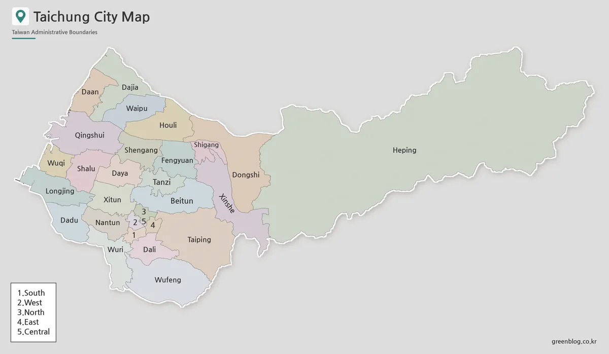
Designed with Taichung’s district density in mind, the color version separates the 29 districts so viewers can read the city structure faster. This is especially useful in the central area, where several small districts sit close together and boundary lines can feel crowded without clear color contrast.
The western coastal side also benefits from color separation. Dajia, Qingshui, Shalu, Wuqi, Daan, Dadu, and Longjing form a different visual pattern from the compact urban districts. Heping District adds another contrast because it occupies a much wider mountain-side area. The color map makes these differences easier to explain in presentations, blog posts, classroom references, and regional comparison graphics.
Extra attention was given to the areas around Beitun, Xitun, Nantun, and Central so that labels would remain readable at A3 size. The goal was not only to divide districts by color, but also to keep the overall map from feeling too heavy.
Black and White Printable Version

For reports, worksheets, and printed handouts, a cleaner black and white map can be more practical than a fully colored one. In this version, the focus stays on district names and boundary lines, which makes it easier to place the map beside text, tables, or assignment instructions.
Taichung’s administrative layout includes both very small urban districts and much larger outer districts. Because of that contrast, line thickness and label size need to be balanced carefully. If the lines are too strong, the central districts can look crowded. If the labels are too small, the map becomes difficult to read when printed.
This black and white Taichung City Map is suitable for classroom materials, school reports, document inserts, and regional study sheets. It also works well when users want to mark certain districts by hand.
Blank Outline Map for Editing
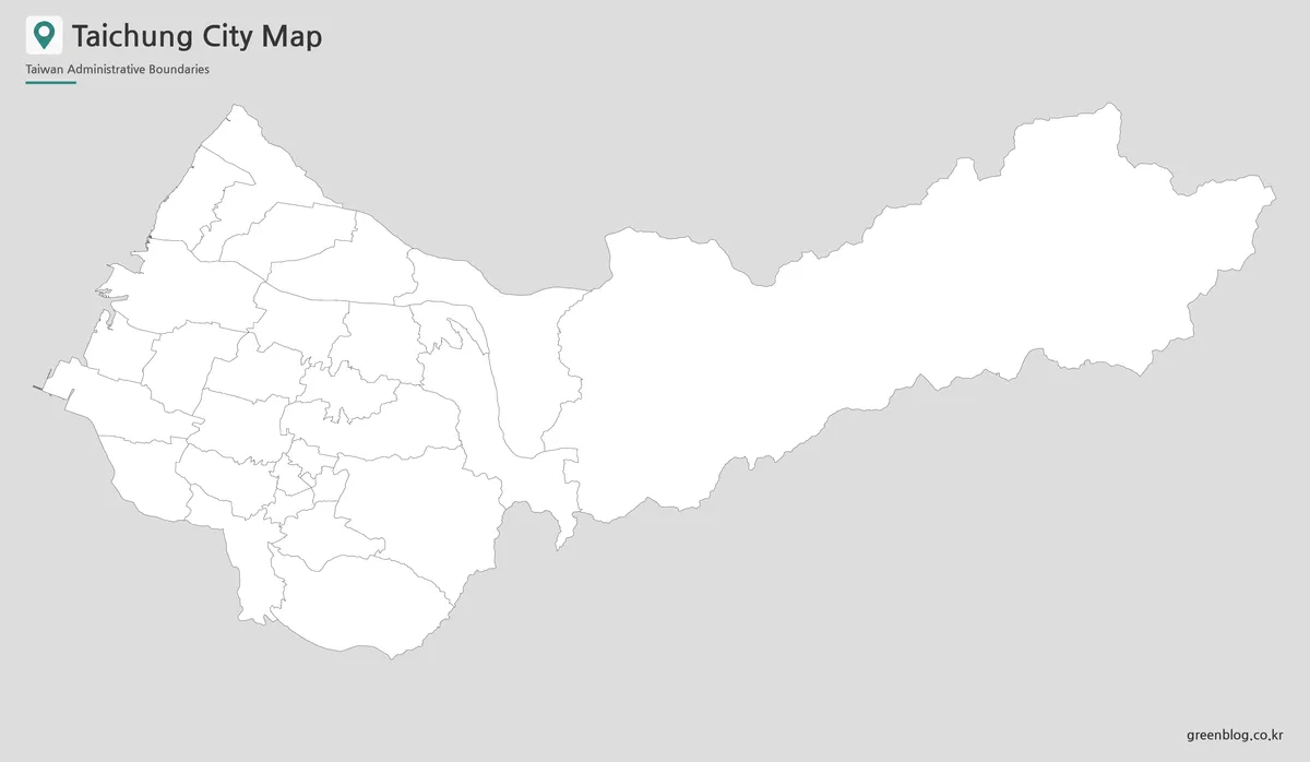
The outline version leaves only the district boundary lines, giving users a flexible working base map. It is useful for coloring activities, custom district grouping, travel route marking, presentation highlights, and infographic annotations.
For Taichung City, the outline map is especially helpful when comparing urban, coastal, and mountain-side areas. A teacher may use it for a Taiwan geography worksheet, while a designer may add icons, arrows, district colors, or data labels. Travel writers can mark routes between the central districts and coastal areas, and presentation creators can highlight Heping or Xitun without unnecessary background details.
Because the visual elements are kept simple, the outline version is easier to customize than a labeled color map. It gives enough structure to show the city boundary system while leaving room for custom text, color fills, and project-specific notes.
Designed for Classroom, Blog, and Presentation Use
This Taichung City Map collection was prepared for practical visual work. Teachers can use the maps for Taiwan geography lessons, students can include them in reports, and bloggers can use them when writing about Taichung travel, city districts, or regional comparisons.
Presentation creators may prefer the color map when explaining the city layout quickly. The black and white version fits better into formal documents, while the outline version is the most flexible choice for editing and custom annotations.
The layout was checked with larger print use in mind. Since the central districts are compact and the eastern district is much wider, the map needed enough spacing to keep both dense and broad areas readable.
Frequently Asked Questions
What is included in this Taichung City Map collection?
The collection includes a color district map, a black and white map, and a blank outline map of Taichung City.
Is this Taichung City Map suitable for A3 printing?
Yes. The map was prepared for A3-size printing, making it suitable for larger classroom handouts, presentation boards, and printed reference sheets.
What file format is included?
The map files are provided in JPG format.
Should every label include “District” on the map?
Not necessarily. Since Taichung has 29 districts, shorter labels such as Xitun, Beitun, Fengyuan, and Heping are easier to read inside the map. The full district names can be used in captions or article text.
Is the outline version editable?
Yes. The blank outline map is useful for adding colors, labels, markers, travel routes, data points, or custom infographic elements.
Taichung City Map Download
Download the Taichung City Map collection with color, black and white, and outline versions. The files are designed for printing, classroom reference, presentation slides, blog graphics, and editable map projects.
- File Format: JPG
- Included Versions: Color Map / Black and White Map / Outline Map
- Printable Size: A3
- Intended Use: Classroom materials, presentations, blog images, infographic editing
Additional Resources
- Taichung City Open Data Platform : A useful official map-related resource for checking Taichung City district boundary and administrative map information.
Related Maps
Green Map creates custom-edited map images using open geographic data sources such as geoBoundaries, Natural Earth, OpenStreetMap, and government open data.
These maps are edited visual materials, not raw data files, and are provided for education, documents, presentations, and graphic reference.