A Yemen map is useful when you need more than a simple country location image. Yemen sits on the southwestern side of the Arabian Peninsula, bordered by Saudi Arabia to the north and Oman to the east. Its coastline follows the Red Sea, the Gulf of Aden, and the Arabian Sea, so the country often appears in materials related to Middle East geography, regional comparison, maritime routes, and classroom lessons.
This printable Yemen map collection includes color, black and white, and outline versions prepared for A3 layout use. The files are designed as image-based map resources for educational materials, presentation slides, document printing, blog graphics, and basic infographic editing. Because Yemen includes both mainland governorates and the island region of Socotra, a well-organized map helps readers understand the full national layout more clearly than a text description alone.
The administrative structure is also important. Western Yemen contains many smaller governorates, including areas around Sanaa, Ibb, Dhamar, Taiz, Al Hudaydah, and Al Mahwit. In contrast, eastern Yemen includes much larger areas such as Hadramaut and Al Mahrah. This difference in scale makes the map visually uneven in a useful way: it shows why some labels need careful spacing while other regions have more room for notes, markers, or presentation highlights.
During the map preparation process, attention was given to regional readability. The western governorates are more compact, so label placement and boundary contrast matter more there. The eastern and southern regions need a different approach because the areas are wider and better suited for annotations. The outline version is especially helpful for users who want to add routes, highlight coastal areas, mark Socotra, or compare Yemen with nearby countries.
Table of Contents
Yemen Map Overview
This Yemen map collection is built around practical use. Instead of focusing on long background information, the layout is designed to help users quickly identify governorates, coastlines, neighboring countries, and separated areas such as Socotra.
The map can be used for:
- classroom handouts
- geography worksheets
- Middle East presentation slides
- blog graphics
- regional comparison materials
- infographic editing
- printable study resources
Yemen’s shape makes it a useful country map for visual explanation. The western side is dense with smaller governorates, while the east opens into larger administrative areas. The southern coastline also helps explain Yemen’s connection to the Gulf of Aden and Arabian Sea.
Included Yemen Map Versions
The download set includes three main styles. Each version is intended for a different type of project, so users can choose the one that best fits their document, slide, or design layout.
Color Yemen Governorate Map
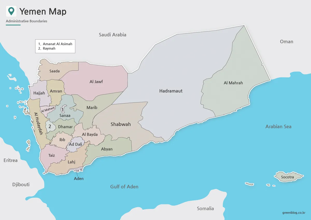
The color version is the easiest option when you want to show Yemen’s internal divisions quickly. Color separation is especially helpful in western Yemen, where several governorates are placed close together around Sanaa, Dhamar, Ibb, Raymah, Taiz, and Al Hudaydah.
For presentations, this version works well when explaining how Yemen’s compact western regions differ from the larger eastern governorates. Hadramaut and Al Mahrah take up broad areas, while the western governorates appear more clustered. The color layout makes that contrast easier to understand at a glance.
Practical use:
Use the color map for slide decks, regional comparison graphics, classroom screens, and blog images where visual separation is more important than minimal design.
Black and White Printable Yemen Map
The black and white version is made for clean document use. It keeps the focus on boundaries and place names without strong color blocks, which makes it suitable for printed handouts, reports, or worksheets.
This version is useful when the map needs to sit inside a document with text. Yemen’s dense western governorates can become visually crowded if the design is too heavy, so a cleaner black and white layout helps keep labels readable. It also works well for users who want a formal map style for educational or reference materials.
Practical use:
Choose this version for worksheets, printed study sheets, reports, PDF-style handouts, and simple presentation reference pages.
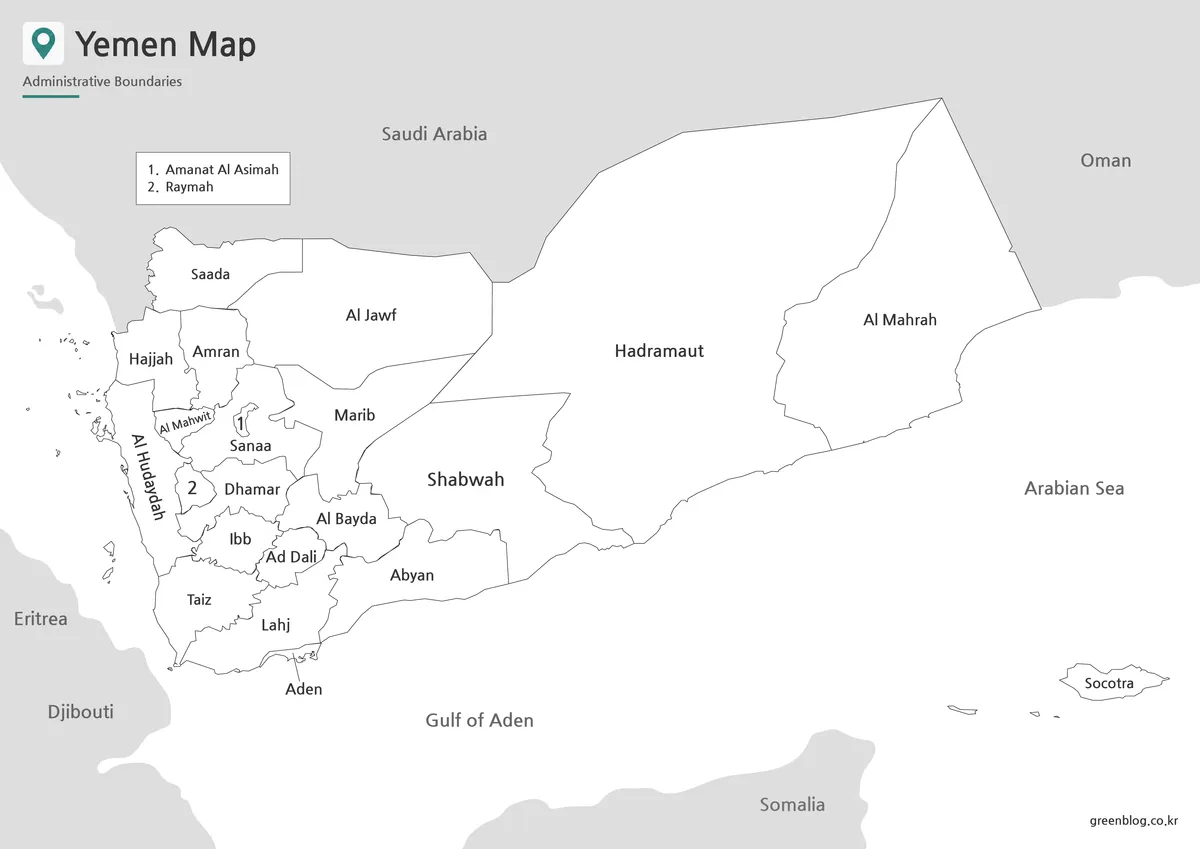
Blank Yemen Outline Map
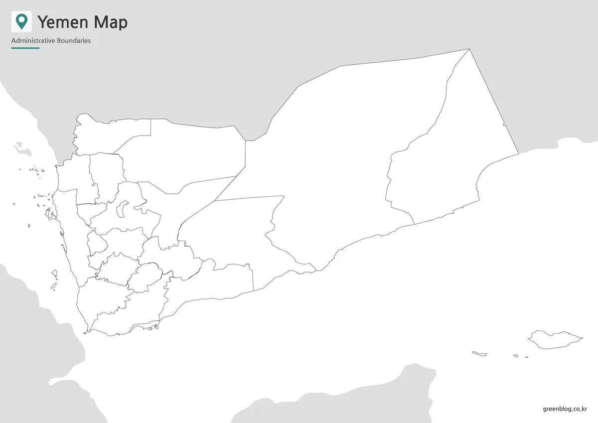
The outline map is designed as a working base map. It removes visual distractions and leaves the governorate boundaries available for editing, coloring, and annotation.
This is the best choice when users want to add their own information. Teachers can use it for coloring activities or geography quizzes. Designers can add region highlights, arrows, city markers, or data labels. Bloggers and video creators can mark coastlines, neighboring countries, maritime routes, or the island of Socotra.
Because Yemen includes both compact and wide governorates, the outline version gives users flexibility. Smaller western areas can be numbered or shaded, while larger eastern and southern areas provide more space for custom labels.
Built for Printing and Visual Reference
The files are prepared for A3 layout use, which makes them suitable for larger print formats and presentation design. A3 size is helpful for Yemen because the western part of the country contains many smaller administrative areas. Enlarging the map gives more room for labels and makes boundary lines easier to follow.
The map can also be scaled down for blog graphics or slide images, but the best readability is usually achieved when the map is used at a larger size. The black and white version was checked with document-style use in mind, while the outline version is better suited for custom editing and annotation.
Practical Ways to Use This Yemen Map
A Yemen map can be useful in many types of content. In a classroom, it can help students identify the country’s location between Saudi Arabia, Oman, the Red Sea, and the Gulf of Aden. In a presentation, it can support explanations about regional divisions, coastal geography, and the difference between mainland Yemen and Socotra.
For design work, the outline map is useful as a base layer. You can add arrows, highlight specific governorates, mark coastal areas, or create a regional comparison graphic. For blog posts or educational articles, the color map gives a quick visual overview without requiring a long explanation.
Frequently Asked Questions
What is included in this Yemen map collection?
The collection includes a color map, a black and white map, and a blank outline map.
Can I print the Yemen map in A3 size?
Yes. The map files are prepared for A3 layout use, which helps keep governorate boundaries and labels readable.
Which version is best for classroom handouts?
The black and white version is usually best for printed handouts. The outline version works well for worksheets and coloring activities.
Is the outline map editable?
Yes. The outline version can be used as a base map for adding colors, labels, routes, arrows, or infographic notes.
Does the map include Socotra?
Yes. Socotra is included so the Yemen map can show both the mainland and the separated island region.
Download Yemen Map
This download includes printable Yemen map versions for educational use, presentation design, document printing, and editable graphic projects.
- Included Versions: Color map, black and white map, outline map
- Printable Size: A3 layout
- File Type: Image files
- Intended Use: Classroom handouts, presentations, blog graphics, infographic editing, and printable reference materials
Additional Resources
- HDX – Yemen Subnational Administrative Boundaries : A GIS boundary dataset that can help users compare Yemen’s administrative divisions and understand the source structure behind governorate-level mapping.
Related Maps
- Tajikistan Map Download – Printable Regional Map Set
- Saudi Arabia Map Download – Printable Color, Black and White, and Outline Maps
- Bhutan Map in High Resolution for Presentations and Worksheets
- Turkmenistan Map with Caspian Sea and Neighboring Countries
Green Map creates custom-edited map images using open geographic data sources such as geoBoundaries, Natural Earth, OpenStreetMap, and government open data.
These maps are edited visual materials, not raw data files, and are provided for education, documents, presentations, and graphic reference.