A Bhutan map is useful when you need more than a simple location image of the country. Bhutan sits in the eastern Himalayas between India and China, with a long east-west shape and a mountainous landscape that can be difficult to explain with text alone. Because the country is compact but geographically varied, a clear printable map helps readers understand where the capital, regional divisions, and border areas are located.
This printable Bhutan map collection includes color, black and white, and outline versions designed for classroom reference, presentation slides, blog graphics, document printing, and editable graphic projects. The files are prepared as image files in an A3 layout, making them easier to use in printed materials or visual resources where small online map previews are not enough.
Bhutan is often discussed together with India, Nepal, Bangladesh, and the Himalayan region. For students, teachers, bloggers, and presentation creators, the country’s location between the Tibetan Plateau and northeastern India is an important part of the visual explanation. A labeled and printable map can make that regional relationship much easier to show, especially when comparing South Asian countries or explaining mountain geography.
While preparing this map collection, the main focus was readability. Bhutan’s administrative divisions stretch across a narrow and mountainous national shape, so boundary lines and labels need enough spacing to remain clear. The layout was adjusted for larger print use, with attention given to boundary visibility, label placement, and simple visual separation between regions.
Table of Contents
Map Collection Overview
The collection includes three practical map styles:
- Color map for regional comparison and presentation use
- Black and white map for printing, handouts, and documents
- Outline map for editing, coloring, and custom annotation
Each version serves a different purpose. The color version works well when users need quick visual separation between regions. The black and white version is cleaner for print-based materials. The outline map gives users a simple base for adding their own labels, colors, travel routes, statistics, or classroom notes.
Because Bhutan is a Himalayan country with many areas shaped by mountain terrain, a map can help explain regional layout more clearly than a short written description. The country’s west includes important places such as Thimphu and Paro, while central and eastern areas extend across broader mountain regions. The southern side also connects closely with India, which makes the border layout useful for regional studies and comparison materials.
Color Bhutan Map for Regional Reading
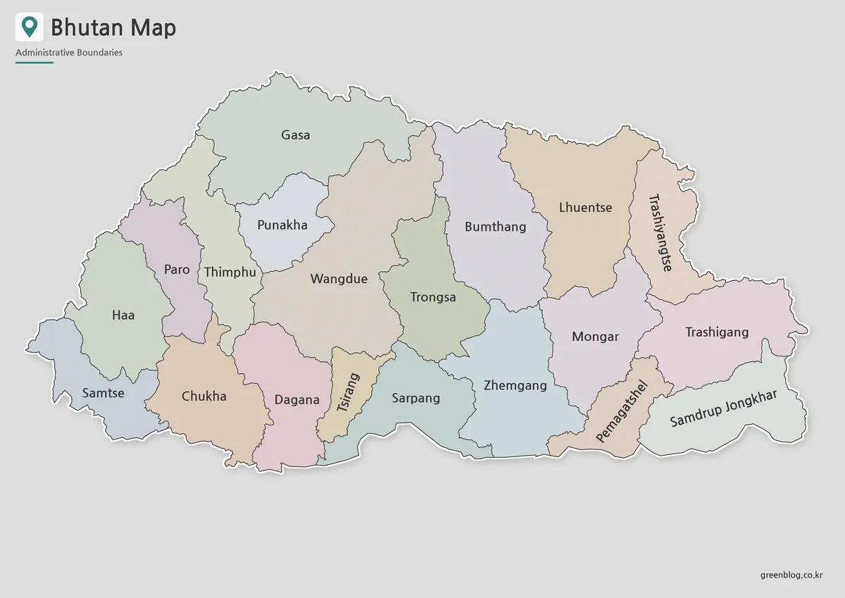
The color map is designed to make Bhutan’s administrative areas easier to compare at a glance. In a country with long east-west geography and mountainous divisions, color separation helps readers follow the regional structure without getting lost in boundary lines.
This version works especially well in presentation slides, blog posts, educational worksheets, and country comparison graphics. When explaining Bhutan’s position between India and China, the color-coded layout gives viewers a faster way to understand how the country is divided internally.
Extra care was given to keeping neighboring colors distinct enough for visual reading. If adjacent areas are too similar, the map becomes harder to read when reduced in size for slides or inserted into a document. The color version is therefore the best choice when the goal is quick recognition and visual comparison.
Black and White Bhutan Map for Printing
For printed handouts and classroom materials, a black and white Bhutan map is often more practical than a full-color version. This style focuses on boundaries and labels, making it suitable for worksheets, reports, reference sheets, and simple document layouts.
Bhutan’s narrow shape means that labels can become crowded if the map is too small. The black and white layout keeps the design clean so that regional names and boundary lines remain readable in printed form. It is also useful when color printing is not available or when the map needs to blend into a report or workbook.
Teachers may use this version for geography lessons, while students can place it inside assignments or presentation notes. It also works well for bloggers who want a simple map image that does not visually compete with surrounding text or graphics.
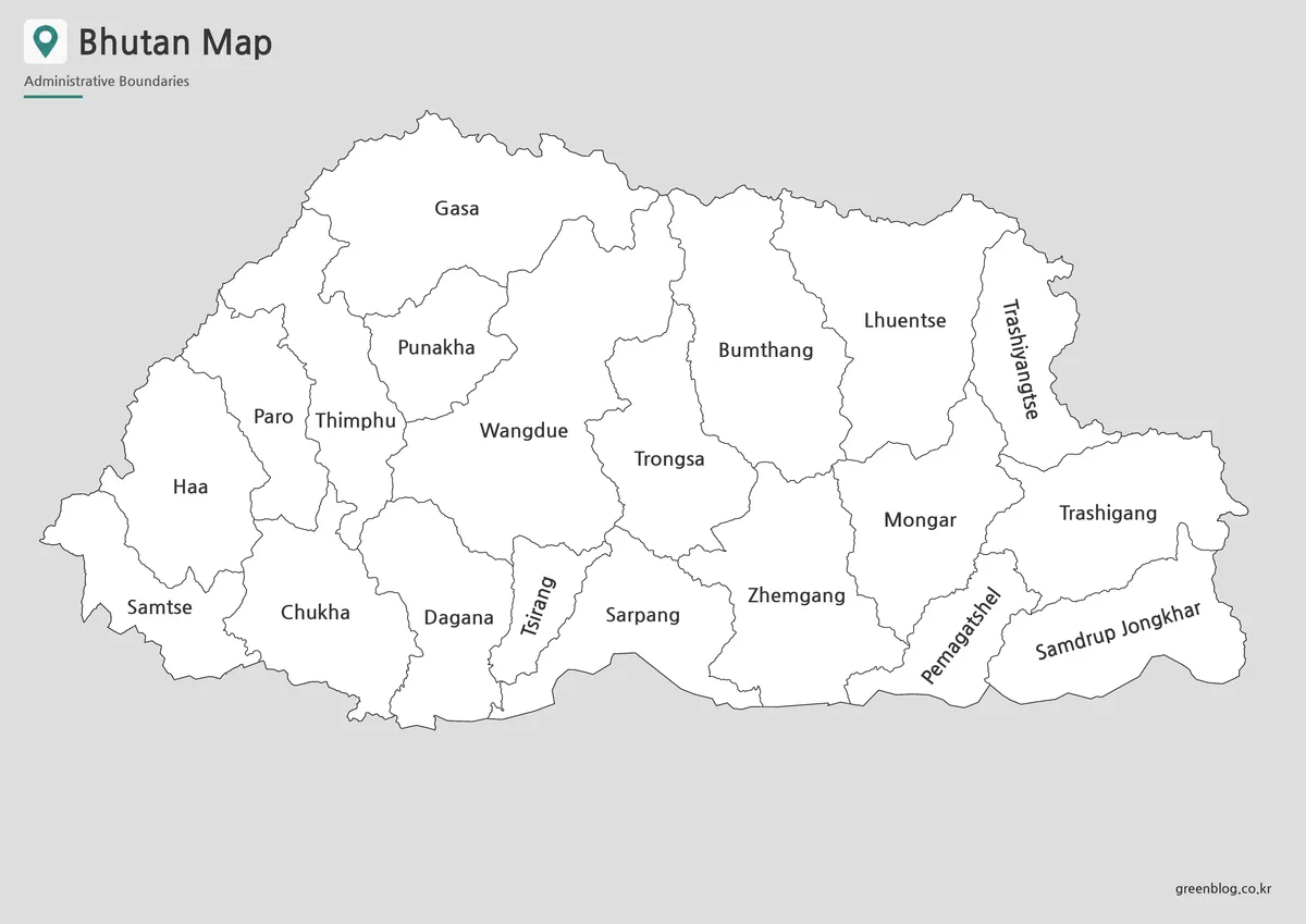
Bhutan Outline Map for Editing and Custom Projects
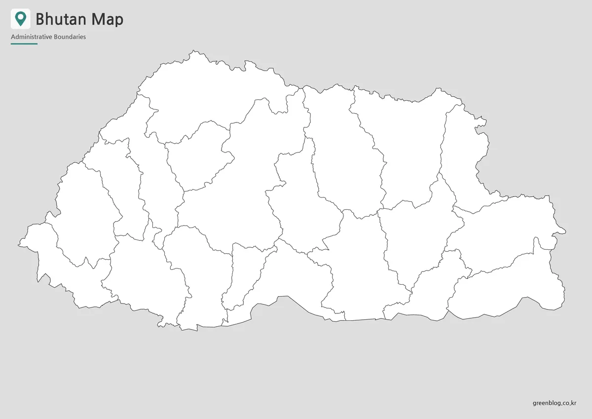
The outline map provides a clean boundary-based version of Bhutan without color fills. This makes it useful as a working base map for editing, annotation, and custom visual projects.
Users can add their own colors, mark specific regions, highlight the India border, label the capital area, or create a simple classroom coloring activity. It can also be used for infographic layouts where custom data needs to be placed over the map, such as regional comparisons, travel routes, administrative grouping, or educational notes.
The outline version is especially helpful when you want the map to act as a background rather than the main design element. Designers and content creators can place markers, arrows, labels, or shaded areas without having to remove existing color blocks first.
Practical Uses for the Bhutan Map
This Bhutan map collection can support several types of projects. In education, it works as a classroom reference for South Asia, Himalayan geography, and country comparison activities. For presentations, the map can help explain Bhutan’s position between India and China more clearly than a written description alone.
Bloggers and content creators can use the color version for visual articles about Bhutan, South Asia, or Himalayan countries. The black and white version fits printable handouts, worksheets, and reference documents. The outline version is useful for anyone who wants to create a custom visual, such as a travel route map, infographic, or labeled study sheet.
Because the map collection includes multiple styles, users do not need to rely on one version for every purpose. A presentation may look better with the color map, while a worksheet may need the black and white version. For design work, the outline map offers the most flexibility.
Built for Visual Clarity
The map was prepared with printable readability in mind. Small online maps often look acceptable on screen but lose clarity when enlarged or placed inside documents. For this collection, the boundary layout and label balance were reviewed so that the map remains useful beyond a small preview image.
A3 layout support makes the files better suited for posters, classroom displays, presentation graphics, and large-format reference materials. The goal is not only to show where Bhutan is located, but also to provide map files that can be used directly in educational and visual projects.
Frequently Asked Questions
What is included in the Bhutan map collection?
The collection includes color, black and white, and outline versions of the Bhutan map. Each version is prepared for different uses, including printing, presentations, classroom materials, and editing projects.
Can I print the Bhutan map?
Yes. The map files are designed for A3 layout use, which makes them suitable for larger printed materials, classroom handouts, and presentation boards.
Which Bhutan map version is best for classroom use?
The black and white version is best for worksheets and printouts. The color version works well for classroom slides, while the outline version is useful for coloring or labeling activities.
Is the outline map editable?
The outline version is useful for editing because it provides clean boundary lines without color fills. You can add labels, colors, markers, routes, or regional notes depending on your project.
Map File Information
This download includes printable Bhutan map versions for educational use, presentation design, document printing, and editable graphic projects.
- Included Versions: Color map, black and white map, outline map
- Printable Size: A3 layout
- File Type: Image files
- Intended Use: Classroom handouts, presentations, blog graphics, infographic editing, and printable reference materials
Additional Resources
- Bhutan NSDI System – Boundaries : Bhutan NSDI System provides map-related boundary information for Bhutan, including administrative boundary data that can help users understand Dzongkhag and Gewog divisions.
Related Maps
- Turkmenistan Map with Caspian Sea and Neighboring Countries
- Printable Sri Lanka Map Collection – Labeled, Blank, and Outline Versions
- Myanmar Map – Printable Color, Black and White & Outline Map
- Malaysia Map Resource with Color, Basic, Outline, and Flag Images
Green Map creates custom-edited map images using open geographic data sources such as geoBoundaries, Natural Earth, OpenStreetMap, and government open data.
These maps are edited visual materials, not raw data files, and are provided for education, documents, presentations, and graphic reference.