The Tajikistan map in this collection was prepared for users who need a clear visual reference for Central Asia, regional boundaries, and classroom or presentation materials. Tajikistan is a landlocked country in Central Asia, bordered by Kyrgyzstan to the north, Uzbekistan to the west, Afghanistan to the south, and China to the east. Because the country sits among several neighboring states and has a strongly mountainous layout, a simple location map is often not enough when explaining its regional structure.
This printable Tajikistan map collection includes color, black and white, and outline versions. The files are designed for A3 layout use and general image-based projects, making them suitable for classroom handouts, geography worksheets, presentation slides, blog graphics, infographic layouts, and editable visual materials. The color version helps separate the main administrative regions, the black and white version keeps the layout clean for printing, and the outline version gives users a simple base for adding labels, colors, routes, or regional data.
Tajikistan’s administrative layout is visually interesting because the regions are not evenly shaped or evenly distributed. Sughd sits in the northern part of the country, Dushanbe appears as a small capital region, Khatlon is located toward the southwest, and Gorno-Badakhshan covers a large eastern mountain area. The Districts of Republican Subordination also form an important central administrative area. When preparing this map set, extra attention was given to keeping the smaller capital area visible while still showing the broad eastern and northern regions clearly.
A printable regional map is useful for students studying Central Asia, teachers preparing map-based worksheets, bloggers writing about the region, and designers building geographic infographics. It also works well for comparing Tajikistan with nearby countries such as Kyrgyzstan, Uzbekistan, Afghanistan, and China.
Table of Contents
Map Versions Included
This Tajikistan map set includes three practical versions for different use cases. Each one is meant to reduce extra editing work, so users can choose the layout that fits their project from the beginning.
The color map is best when the goal is quick visual understanding. The black and white map is better for printing, document insertion, and worksheet-style use. The outline map is designed as a working base for editing, highlighting, coloring, or adding custom information.
Color Tajikistan Regional Map
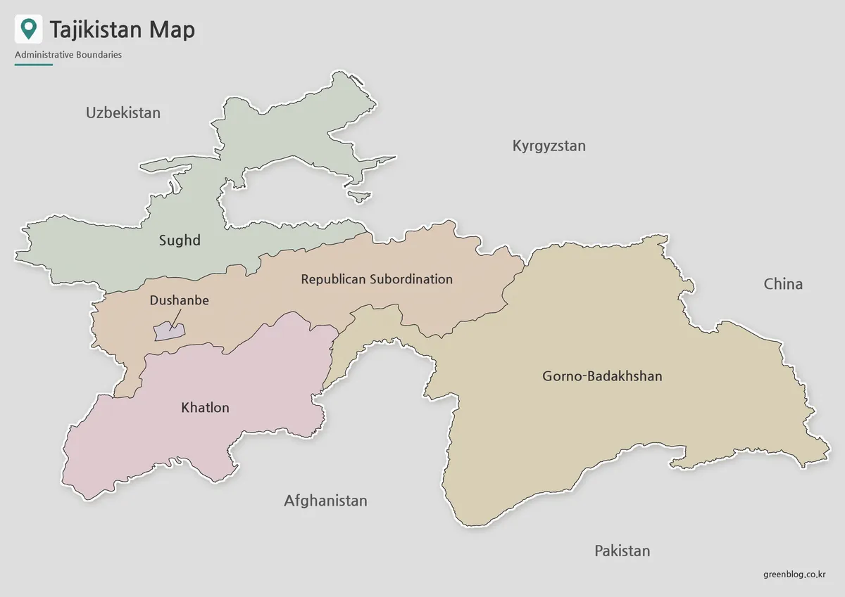
Designed with regional comparison in mind, the color version separates Tajikistan’s main administrative areas so the viewer can quickly understand the country’s internal layout. This is especially helpful because the eastern part of the country, Gorno-Badakhshan, occupies a large mountainous area, while Dushanbe is much smaller and needs careful placement to remain visible.
The color map works well in presentation slides, classroom lessons, and blog posts where the reader needs to see how Tajikistan is divided. It can also support Central Asia comparison materials, especially when explaining how the country connects with Kyrgyzstan, Uzbekistan, Afghanistan, and China.
During the map preparation process, the contrast between neighboring regions was adjusted so that small and large areas could be read together. Without clear separation, the smaller capital area can be easy to miss, while the larger eastern region can dominate the page too much.
Black and White Tajikistan Map
For printed materials, the black and white Tajikistan map provides a cleaner layout focused on boundaries and labels. This style is useful for classroom packets, reports, worksheets, and document inserts where color is not necessary or where printing in grayscale is preferred.
Because Tajikistan has a narrow and mountainous shape with long border lines, line clarity matters more than decoration in this version. The simplified layout keeps the regional structure readable when the image is placed inside a report or reduced for a presentation slide.
The map was checked with A3 output in mind, so the regional outlines remain visible at larger print sizes. It can also be used as a reference sheet for students who need to identify the country’s major regions without the distraction of color blocks.
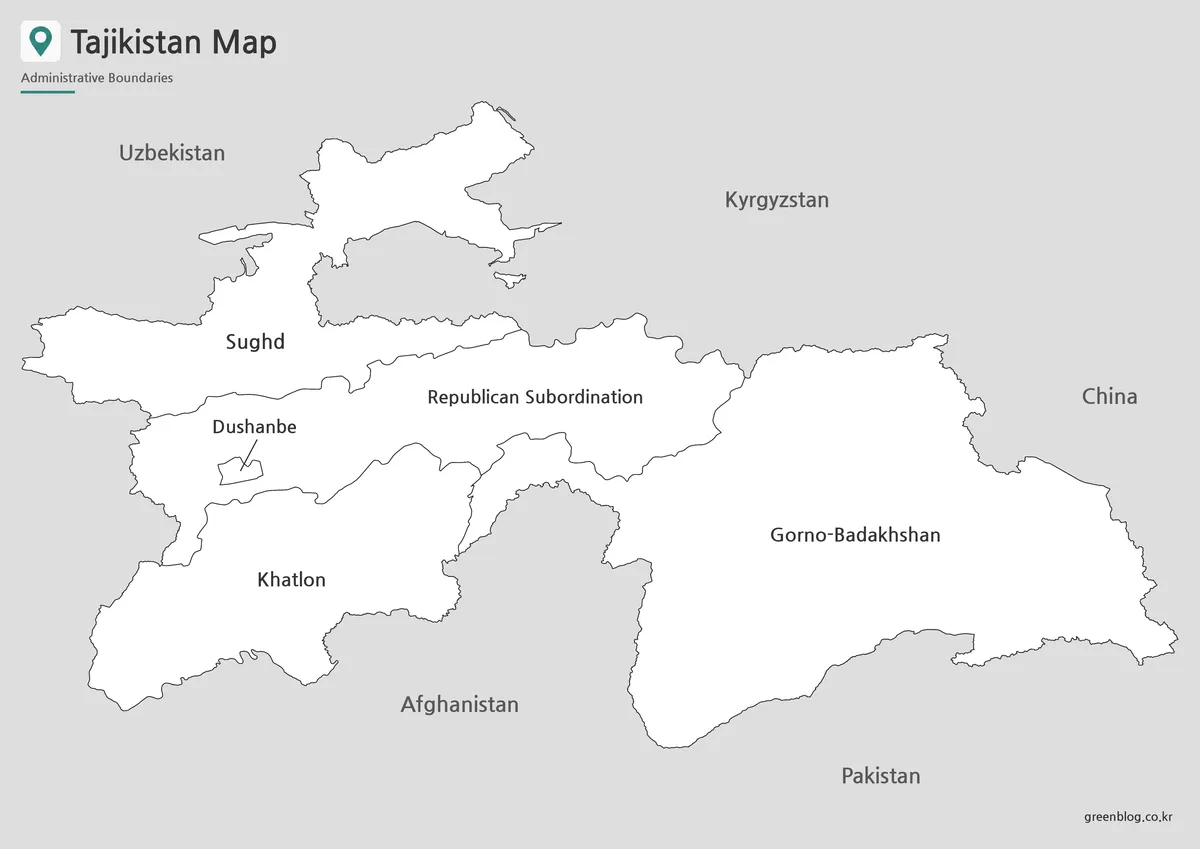
Blank Tajikistan Outline Map for Editing
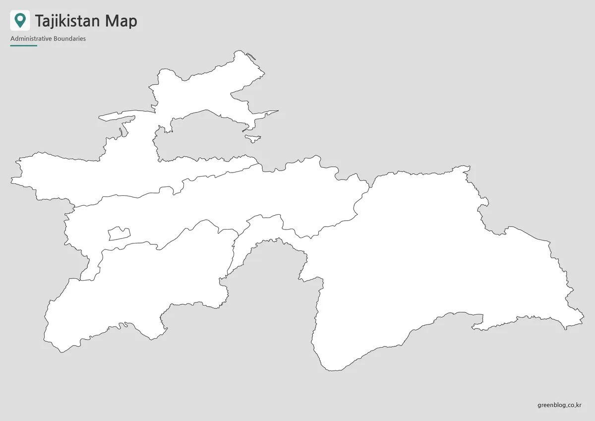
The outline version works as a clean base map for editing and custom marking. It removes color and extra visual weight while keeping the regional boundary structure visible. This makes it useful for teachers, students, infographic creators, and anyone who wants to add information directly onto the map.
Users can mark the capital city, highlight Gorno-Badakhshan, compare Sughd and Khatlon, show travel routes, add neighboring-country arrows, or place data points related to population, geography, elevation, or regional comparison. For classroom use, the outline map can also support coloring activities or map-labeling exercises.
This version is especially helpful when the final graphic needs its own color scheme. Instead of removing existing colors from a finished map, designers can start with the blank boundary layout and build their own visual style.
Practical Uses for This Tajikistan Map
A printable Tajikistan map is useful whenever the regional layout matters more than a simple country silhouette. Teachers can use it for Central Asia geography lessons, students can include it in school reports, and presentation creators can use it to explain how Tajikistan connects with surrounding countries.
For blog and infographic work, the map can serve as a visual base for topics such as Central Asian geography, mountain regions, border relationships, travel planning, or regional comparison. The three-version set also gives users more flexibility. The color map is ready for visual explanation, the black and white map is clean for printing, and the outline map is better for custom editing.
Frequently Asked Questions
What is included in this Tajikistan map collection?
The collection includes a color map, a black and white map, and an outline map of Tajikistan. Each version is intended for a different use, including printing, classroom reference, presentation design, and graphic editing.
Can I print the Tajikistan map in A3 size?
Yes. The map set is prepared for A3 layout printing, making it suitable for larger classroom handouts, reference sheets, and presentation boards.
Which version is best for editing?
The outline map is the best choice for editing. It provides the regional boundary layout without color, so users can add labels, highlights, icons, travel routes, or data overlays.
Does the map include Tajikistan’s administrative regions?
Yes. The map includes the main ADM1 regions: Sughd, Dushanbe, Districts of Republican Subordination, Khatlon, and Gorno-Badakhshan Autonomous Region.
Is the black and white map good for worksheets?
Yes. The black and white version is useful for classroom worksheets, printed assignments, document inserts, and simple regional reference materials.
Map File Information
This download includes printable Tajikistan map versions for educational use, presentation design, document printing, and editable graphic projects.
- Included Versions: Color map, black and white map, outline map
- Printable Size: A3 layout
- File Type: Image files
- Intended Use: Classroom handouts, presentations, blog graphics, infographic editing, and printable reference materials
Additional Resources
- geoBoundaries : A useful reference for administrative boundary data and regional map structure for Tajikistan.
Related Maps
- Saudi Arabia Map Download – Printable Color, Black and White, and Outline Maps
- Printable Iraq Map Download in A3 Size (Color, B&W, Outline)
- Cambodia Map Resources – Color, Black and White, and Outline Editions
- Laos Map Download – High Resolution A3 Administrative Map Set
Green Map creates custom-edited map images using open geographic data sources such as geoBoundaries, Natural Earth, OpenStreetMap, and government open data.
These maps are edited visual materials, not raw data files, and are provided for education, documents, presentations, and graphic reference.