A Korean version of this map page is available. View Korean Page
A detailed laos map is often one of the most useful visual resources for understanding mainland Southeast Asia. Laos sits between Thailand and Vietnam and shares borders with China, Cambodia, and Myanmar, making it an important reference point in regional studies, travel presentations, and educational materials. Because the country stretches from north to south in a long vertical shape, a portrait-oriented layout usually provides a clearer view of the entire territory than a traditional horizontal design.
This printable laos map collection was created for users who need more than a simple country outline. The package includes a color administrative map, a black and white labeled map, and an editable outline map. These versions were prepared for classroom reference, travel planning, blog graphics, infographic projects, and presentation slides. The collection focuses on administrative boundaries and regional layout rather than terrain details, making it easier to compare provinces and neighboring countries.
When preparing the maps, special attention was given to the country’s elongated shape and extensive international borders. Directional references for Thailand, Vietnam, China, and Cambodia were included to improve geographic context. The capital city of Vientiane was highlighted with a red marker so users can identify it quickly. Labels were reviewed for readability, and the overall layout was adjusted to remain clear when enlarged for printing or displayed on large screens.
Whether you need a laos map for a classroom handout, a report, a travel presentation, or a graphic design project, each version serves a different purpose. The sections below explain which option may be the best fit for your needs.
Table of Contents
Map Versions Included
The collection contains three different styles:
- Color administrative map
- Black and white labeled map
- Blank outline map
- High-resolution printable layout
- Capital city marked for reference
- Administrative boundaries designed for clear readability
Each version was designed with a specific use case in mind, allowing users to select the most appropriate format for printing, presenting, or editing.
Color Administrative Laos Map
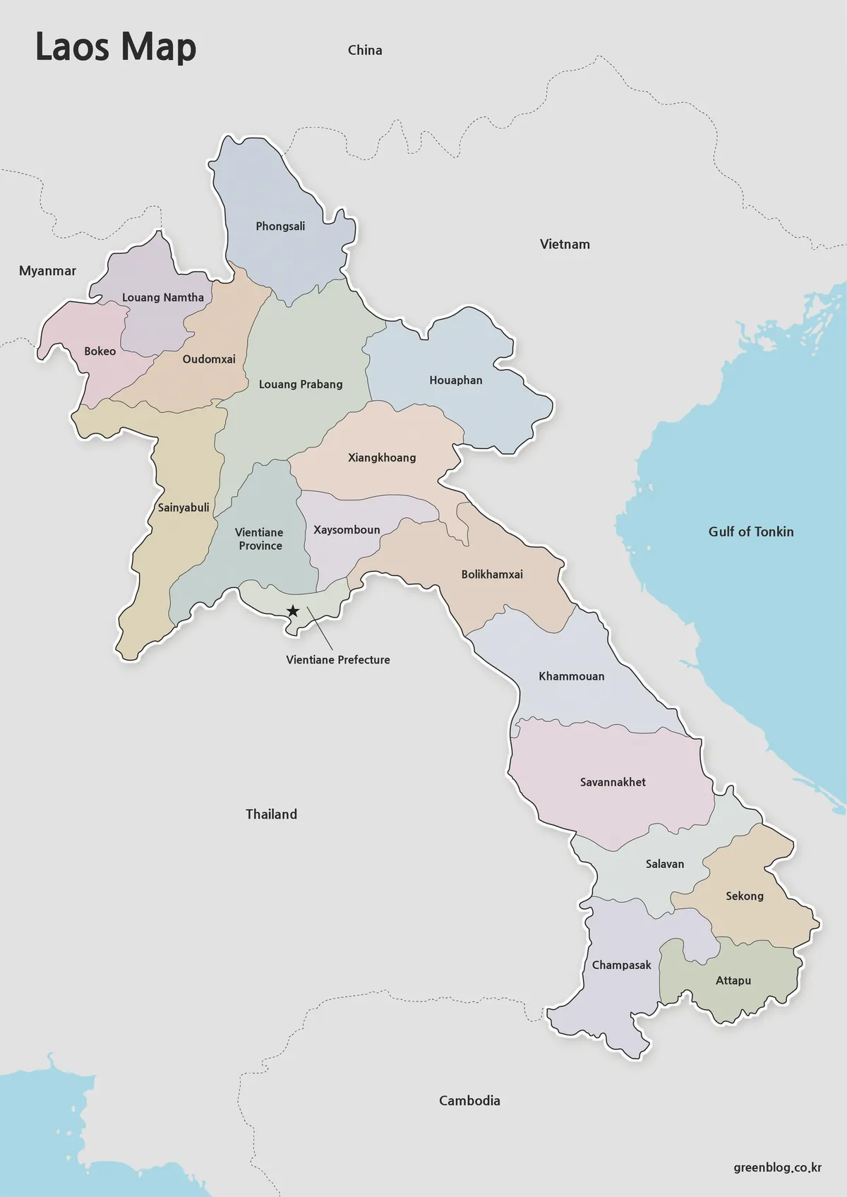
The color laos map was designed for users who need immediate visual distinction between administrative regions. Contrasting colors help separate neighboring provinces, making regional comparisons easier when viewed on a computer screen, projector, or presentation slide.
Because Laos extends over a considerable north-to-south distance, provincial relationships can be difficult to understand in a monochrome layout. Color coding improves readability and makes it easier to follow the geographic flow from northern provinces to southern regions. Both Korean and English place names were included to support multilingual reference materials.
An additional detail incorporated into this laos map was the inclusion of Xaisomboun Province, which is sometimes omitted from older international map references. Administrative boundaries were checked carefully to reflect current regional divisions.
Printable Laos Map for Reports and Study Materials
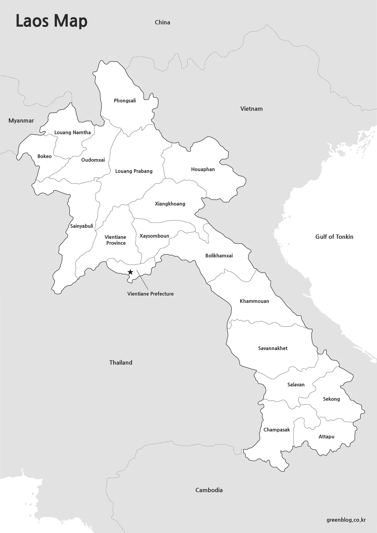
Not every project requires color. The black and white laos map focuses on boundaries and labels while removing color fills that may not reproduce well on standard printers.
This version works particularly well for:
- Geography lessons
- Classroom worksheets
- Printed reports
- Study guides
- Educational presentations
- Regional comparison projects
The layout was reviewed for black and white printing to ensure that boundaries remain visible without relying on color differences. Users who plan to add notes, highlight routes, or mark locations often find this version more practical than the color edition.
Laos Map Outline for Editing Projects
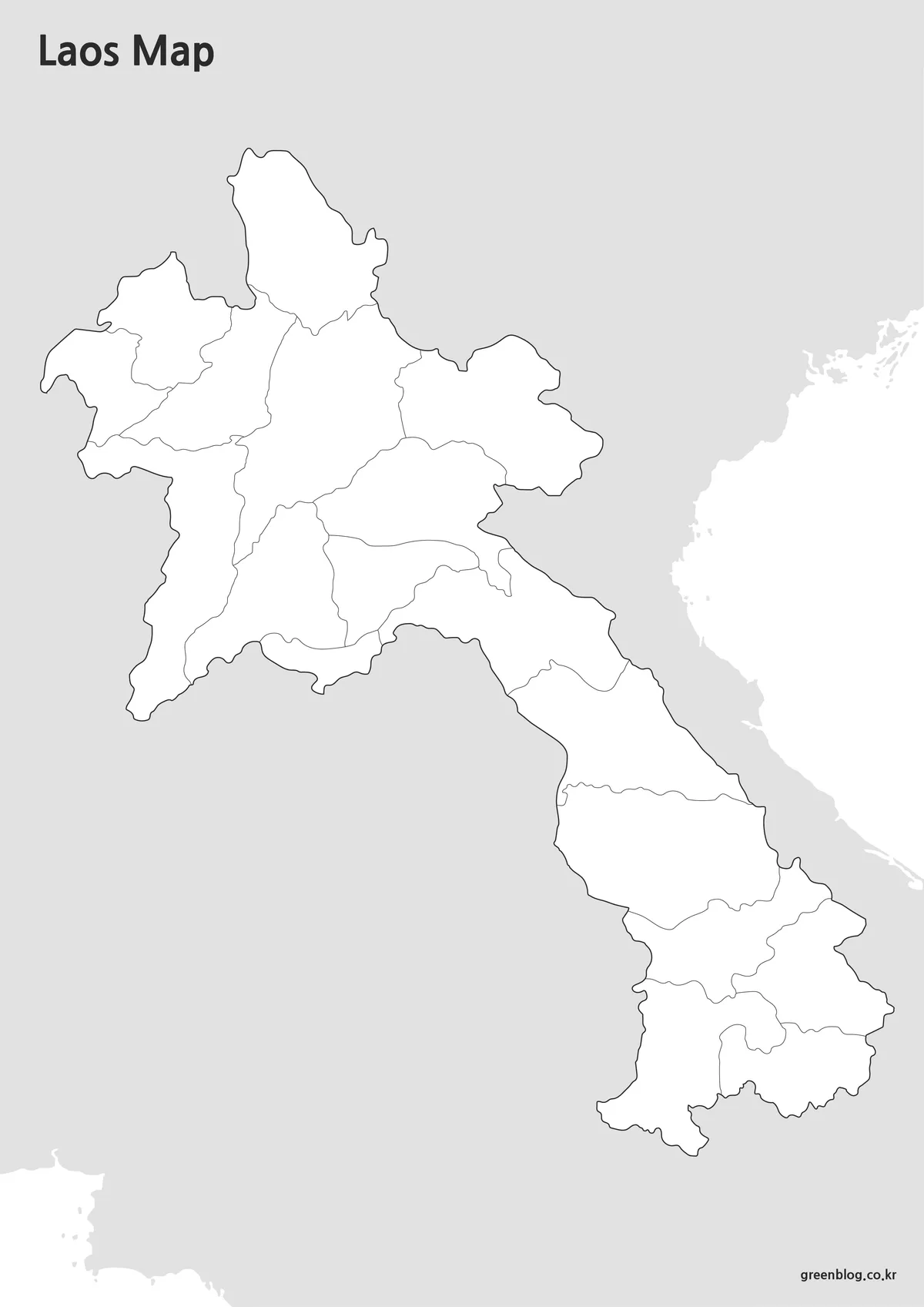
The outline laos map removes labels, symbols, and color fills, leaving only the country outline and administrative boundaries. This format provides a clean foundation for custom projects.
Designers and educators frequently need a blank map for creating worksheets, infographics, business graphics, and travel route visualizations. The simplified structure allows new information to be added without removing existing elements.
Boundary lines were checked to ensure they remain connected, reducing the amount of preparation required when importing the file into Photoshop or Illustrator. The result is a cleaner and more flexible editing experience.
Why a Laos Map Is Useful
A laos map helps users understand how the country connects with neighboring nations while also showing the organization of internal administrative regions. Because Laos is landlocked and stretches vertically through mainland Southeast Asia, visual references often communicate regional relationships more effectively than written descriptions.
Common uses include:
- Travel presentations
- Southeast Asia regional studies
- Classroom geography projects
- Educational worksheets
- Blog graphics
- Infographic design
- Report illustrations
- Custom editing projects
The inclusion of both labeled and editable formats allows users to choose the version that best matches their objectives.
Frequently Asked Questions
Can I print the Laos map in large formats?
Yes. The collection was reviewed for readability at larger print sizes and works well for A3 printing.
Which version is best for presentations?
The color laos map provides the strongest visual distinction between regions and is usually the easiest to read on screens.
Is there an editable version?
Yes. The outline laos map was created specifically for editing, annotations, and custom graphic projects.
Why is the layout vertical?
Laos has a long north-to-south geographic shape, so a portrait orientation provides a clearer view of the entire country.
Laos Map Download
Choose the version that best fits your project. Color, black and white, and outline editions are included for printing, presentations, and editing work.
- Map Types: Color · Black and White · Outline
- Format: High-resolution image files
- Usage: Printing · Education · Presentation · Graphic Editing
Related Maps
- Cambodia Map Resources – Color, Black and White, and Outline Editions
- Printable Iraq Map Download in A3 Size (Color, B&W, Outline)
- China Maps Download Collection – 4 Regional Map Types
- 4 Japan Maps Download Collection for Print and Design
Additional Resources
- HDX Laos Administrative Boundaries – Administrative boundary datasets for Laos are also available through the HDX platform, which provides downloadable geographic boundary resources.
Green Map creates custom-edited map images using open geographic data sources such as geoBoundaries, Natural Earth, OpenStreetMap, and government open data.
These maps are edited visual materials, not raw data files, and are provided for education, documents, presentations, and graphic reference.