A Penghu County map must show relationships across water rather than treating the county as one continuous landmass. Penghu lies in the Taiwan Strait west of Taiwan’s main island, and its administrative areas are distributed among a central cluster, northern islands, and two widely separated southern groups. The long portrait layout keeps those distances visible instead of compressing the archipelago into a compact symbol.
The page provides three matching 1200 × 1697 WebP images. The first uses pastel colors and labels, the second preserves the labels in black and white, and the third removes names and fills to create an outline base. Each version shows the six administrative areas: Magong City plus Huxi, Baisha, Xiyu, Wang’an, and Qimei townships.
The labeled Penghu County map does not include roads, airports, ports, ferry lines, terrain, or navigation data. Its purpose is narrower and clearer: to identify the six divisions, show how their islands are grouped, and preserve the large water gaps between the central and southern parts of the county. Small offshore shapes are included where they remain legible at the published scale.
This distinction matters in classroom and presentation work. On a mainland county map, neighboring areas usually share a visible line. In Penghu, one township may consist of several separate island shapes, and the reader often depends on label placement or color to understand which pieces belong together. The three-map sequence supports identification, low-ink reference, and custom annotation without changing the underlying arrangement.
Table of Contents
Understanding the Island Layout
Read the image from the dense central cluster outward. Magong City occupies the south and southwest of the principal central group. Huxi Township spreads across the eastern side, Xiyu Township lies to the west, and Baisha Township extends north through a chain of islands. These four names form the upper half of the portrait page.
Wang’an Township appears well below the central group and includes multiple separated island shapes. Qimei Township sits still farther south near the bottom of the composition. The broad blank spaces between these labels are not unused page area; they represent the water that makes Penghu’s north-to-south arrangement meaningful.
On the Penghu County map, some small islands lie away from the name placed for their administrative group. Readers should not assume that the nearest label always names an individual island. The labels identify city or township areas, while the coastline shapes show the dispersed geography. Color is the most direct guide when several pieces belong to the same administrative unit.
Administrative Names in English
Penghu County Government’s current English terminology identifies one city and five townships:
- Magong City
- Huxi Township
- Baisha Township
- Xiyu Township
- Wang’an Township
- Qimei Township
The apostrophe in Wang’an separates the two syllables and should be retained when copying the label into a worksheet or caption. Older English-language sources may use other romanizations, but mixing systems can make two references look as though they describe different places. Using the six spellings above keeps labels consistent with the supplied images and current county terminology.
“City” and “Township” also carry useful information. Magong is the single city-level division in this set, while the other five are townships. The map is not a list of six separate islands: each administrative name can cover a principal island and additional smaller islands within the same division.
Color-Coded Penghu County map
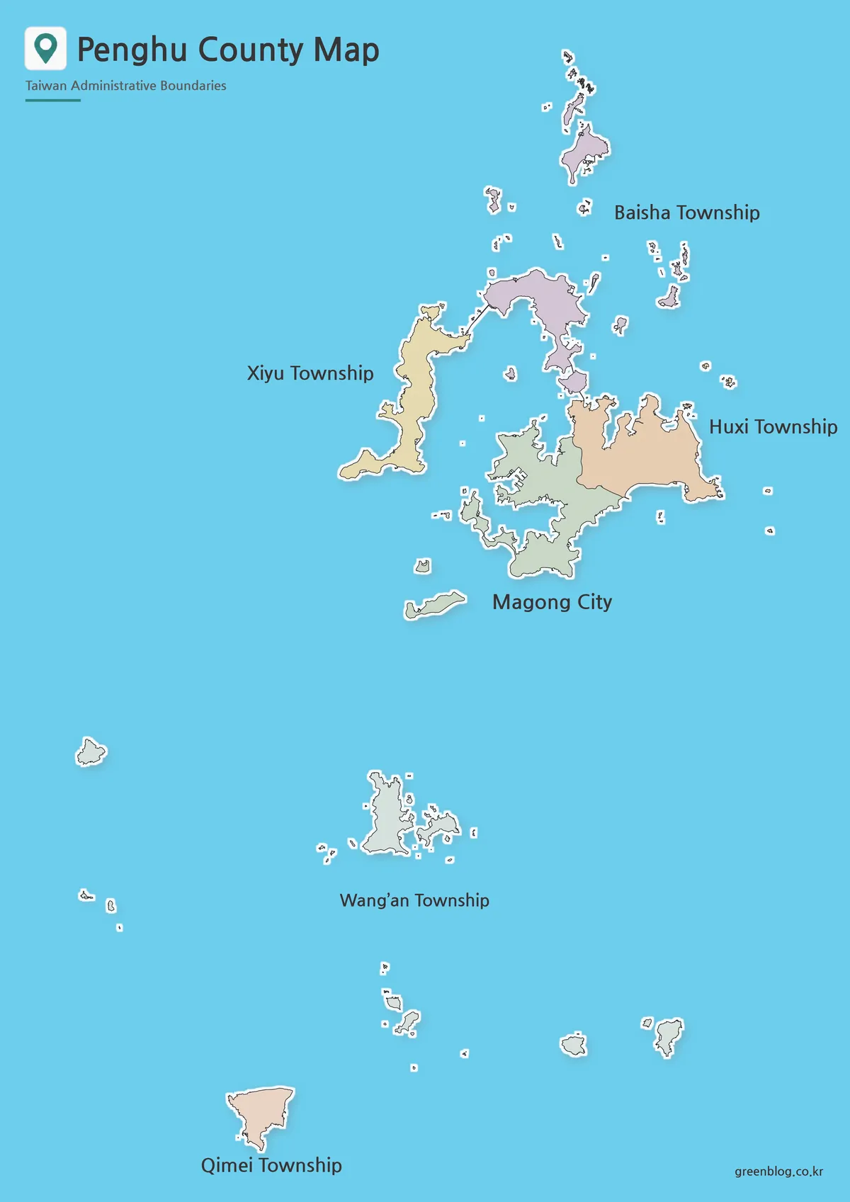
The color Penghu County map is the easiest version for tracing administrative membership across disconnected pieces. Magong is shown in muted green, Huxi in tan, Xiyu in pale yellow, and Baisha in lavender. The southern groups for Wang’an and Qimei remain spatially separate, with their names placed in the broad water area where they can be read without covering small coastlines.
Blue water provides strong contrast with the pale land colors. White edging around island shapes helps very small pieces remain visible, while dark coastlines define the larger islands. The map does not use a legend because the names are printed next to the groups; the fills work mainly as visual grouping cues.
This version is suitable for an opening presentation slide, a county overview, or a regional comparison where viewers need to distinguish the six areas quickly. Keep the full portrait frame when placing it on a landscape slide. Cropping the upper or lower margins can remove parts of Baisha or Qimei and give a false impression of the county’s extent.
Printable Black and White Version
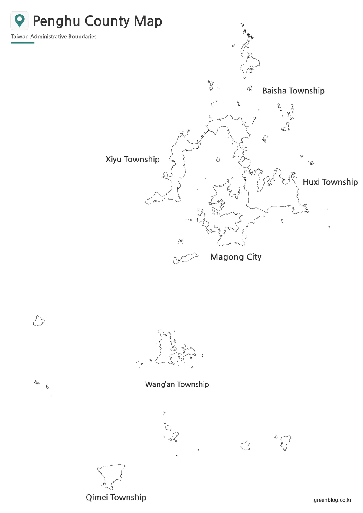
The black and white Penghu County map keeps the six administrative names and coastlines while removing the blue water and pastel fills. This reduces color use and makes the image easier to place beside paragraphs, tables, or other monochrome figures. The large water gaps remain white, so the archipelago’s dispersed arrangement is still clear.
Without color, nearby island shapes can no longer be grouped by fill. The label positions therefore carry more weight. Use this version when the task is to identify the main city and townships, not when a reader must assign every tiny islet to an administrative unit at a glance.
Preview the smallest coastlines before printing a large batch. Automatic “fit to page” settings can shrink the 1200 × 1697 image when wide margins or headers are present. A portrait page preserves more height than a landscape placement, and maintaining the original aspect ratio prevents the gaps between island groups from looking artificially compressed.
Blank Penghu Outline Map for Editing
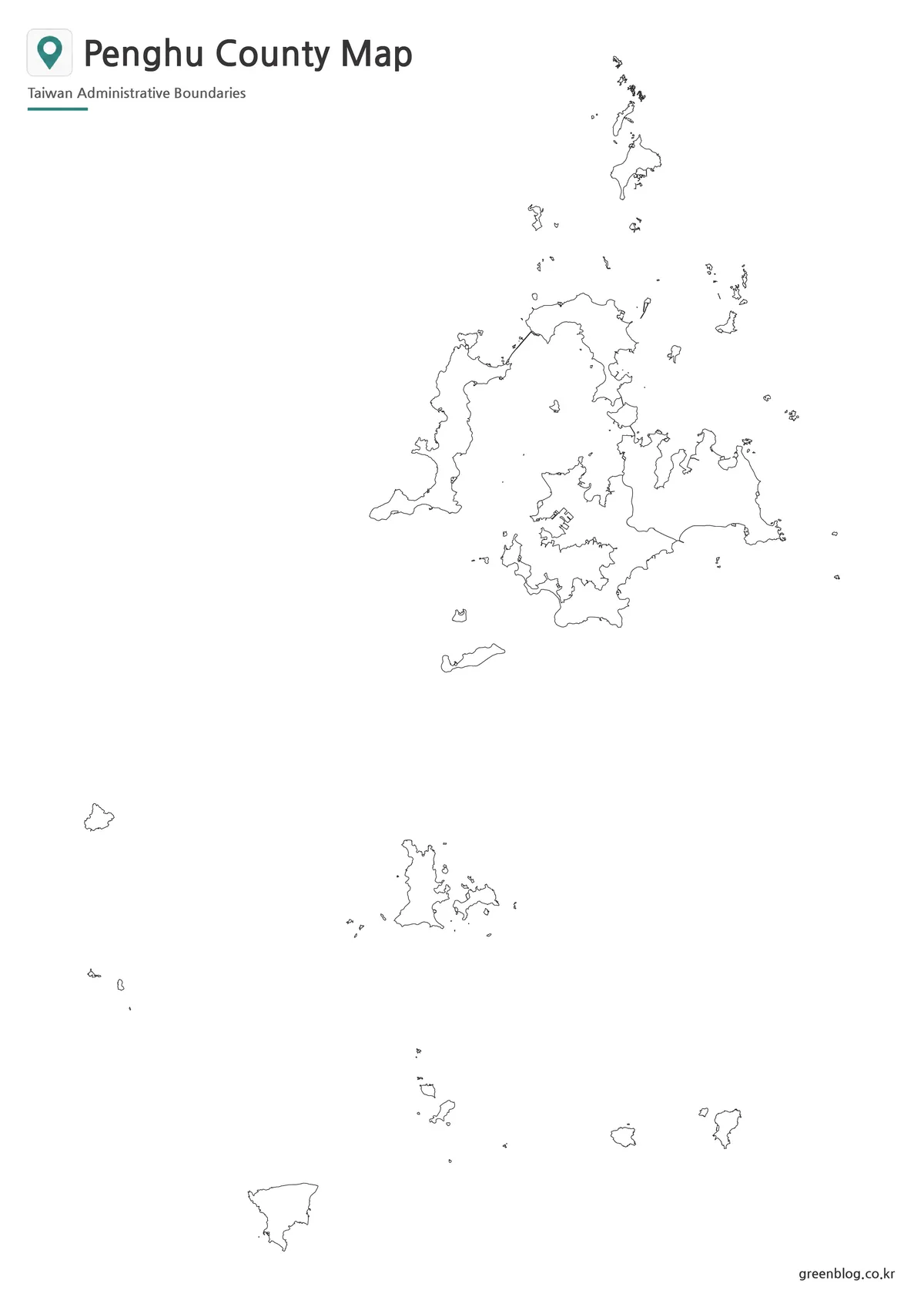
The outline Penghu County map removes the title, subtitle, administrative names, and fill colors. It retains the island coastlines and the internal divisions visible in the central cluster. The result is a working raster image rather than an editable vector file, but its white land areas can accept digital or handwritten colors, numbers, and symbols.
A labeling activity can provide the six official names in a word bank and ask readers to place them in the correct north-to-south positions. A color exercise can assign one hue to each division, using the labeled color map as a reference. A presentation can number the groups on this blank image and reveal the names on the following slide.
Route lines added to the outline are schematic unless they come from a separate transport source. The image itself does not show ferry services, ports, or navigable channels. Likewise, a symbol placed on one island should not be interpreted as representing every island in that township unless the accompanying legend says so.
What the Map Reveals About Penghu
The Penghu County map shows that administrative structure and visual land area are not the same thing. Magong and Huxi appear as substantial neighboring portions of the central group, while Baisha reaches northward through many separated shapes. Wang’an is represented by a loose southern cluster, and Qimei is isolated near the bottom of the page.
Xiyu’s western placement is easy to recognize because its larger island shape sits left of the central group. Baisha forms a northward chain above it and Magong. Huxi expands eastward from the central area. These four labels create a useful orientation frame before the reader moves down the page to Wang’an and Qimei.
The empty water area is therefore part of the information, not merely background. Reducing the vertical gaps would make the southern townships look closer to the central group than they are in the supplied layout. A comparison with a continuous county on Taiwan’s main island should preserve this difference rather than scaling every county silhouette to fill the same compact box.
Practical Uses for the Map Collection
Choose a Penghu County map version according to the reader’s task. The color image is best for immediate administrative separation, black and white is appropriate for a labeled low-ink reference, and the outline supports recall, coloring, or custom data. Because the geometry and dimensions match, the three can be used as a progressive sequence without rebuilding the surrounding page.
- Identify one city and five townships in a Taiwan geography lesson.
- Compare a dispersed island county with a continuous mainland county.
- Practice matching names to central, northern, and southern groups.
- Add a separate legend for classroom or infographic data.
- Explain why water gaps must remain visible when the map is resized.
When publishing or printing the image, retain enough resolution for the smallest island outlines. Do not crop the northern chain or the southern Qimei group to make the central islands larger. If more detail is required, enlarge the complete image or create a clearly labeled inset rather than changing the relative positions of the groups.
Frequently Asked Questions
Is Penghu County part of Taiwan’s main island?
No. Penghu County is an island group in the Taiwan Strait, west of Taiwan’s main island.
How many administrative areas are in Penghu County?
There are six: one city and five townships.
Does the Penghu County map include every small islet?
The maps focus on the main islands and administrative structure. Very small rocks or uninhabited islets may appear simplified at reduced size.
Can I add labels or travel routes to the outline map?
Yes. The blank version works well for adding township colors, ferry routes, tourism points, data labels, and classroom notes.
Which version is best for printing?
The black and white version is the clearest for worksheets and document printing, while the color version is better for presentations and visual comparison.
Download Information
The download contains the three map treatments displayed above, using one consistent portrait composition for labeled reference and custom work.
Map File Information
This download includes the color, black and white, and outline versions shown on this page.
- Included Files: Use only the versions confirmed in the article and supplied images
- File Type: Use the confirmed download contents
- Intended Use: Printing, education, presentations, and map-based projects
Additional Resources
- Penghu County Government — official English information about the county, its geography, public services, and local administration.
Related Maps
Green Map creates custom-edited map images using open geographic data sources such as geoBoundaries, Natural Earth, OpenStreetMap, and government open data.
These maps are edited visual materials, not raw data files, and are provided for education, documents, presentations, and graphic reference.