This Cambodia Map makes two features especially easy to read: the broad provincial pattern around Tonle Sap and the much smaller capital area of Phnom Penh farther south. Cambodia sits in mainland Southeast Asia, with Thailand to the west and northwest, Laos to the north, Vietnam to the east and southeast, and the Gulf of Thailand along its southwest coast. Those surrounding labels provide orientation without turning the page into a crowded regional atlas.
The mapped first-level structure contains 25 areas: 24 provinces plus Phnom Penh. Large northeastern divisions such as Ratanakiri, Mondulkiri, Stung Treng, and Kratie contrast with the closely packed areas around the capital and the lower Mekong plain. Along the coast, Koh Kong, Preah Sihanouk, Kampot, and Kep create another distinct reading sequence, including small offshore shapes that are easy to miss on a reduced copy.
The collection supplies three matching views—a pastel color reference, a labeled monochrome sheet, and an unlabeled outline. Each published preview is a 1200 × 849 WebP image, while the collection is prepared around an A3 layout. Because every Cambodia Map version uses the same geometry, readers can compare an answer sheet with a blank exercise without relearning the arrangement.
Table of Contents
What’s Included in the Collection?
The three images are not interchangeable copies. The color version separates neighboring administrative areas quickly, the black-and-white version retains all printed names with less visual weight, and the blank version removes both names and the Phnom Penh marker. Tonle Sap, the national outline, internal divisions, coast, and nearby land remain aligned across the set.
- Color administrative view: 25 first-level areas in contrasting pastel fills, with Phnom Penh marked by a red star.
- Monochrome reference: the same administrative names, borders, neighboring countries, lake, and capital marker without colored regions.
- Blank outline: internal boundaries and the Tonle Sap shape without labels or a capital symbol.
The artwork is administrative rather than topographic. It does not show the Mekong River, road routes, relief, elevation, district-level boundaries, a scale bar, or a network of provincial capitals. The Phnom Penh star is the only city symbol. These limits make the pages clean for teaching and graphics, but they also mean that route planning and precise spatial measurement require another source.
Color Administrative Version
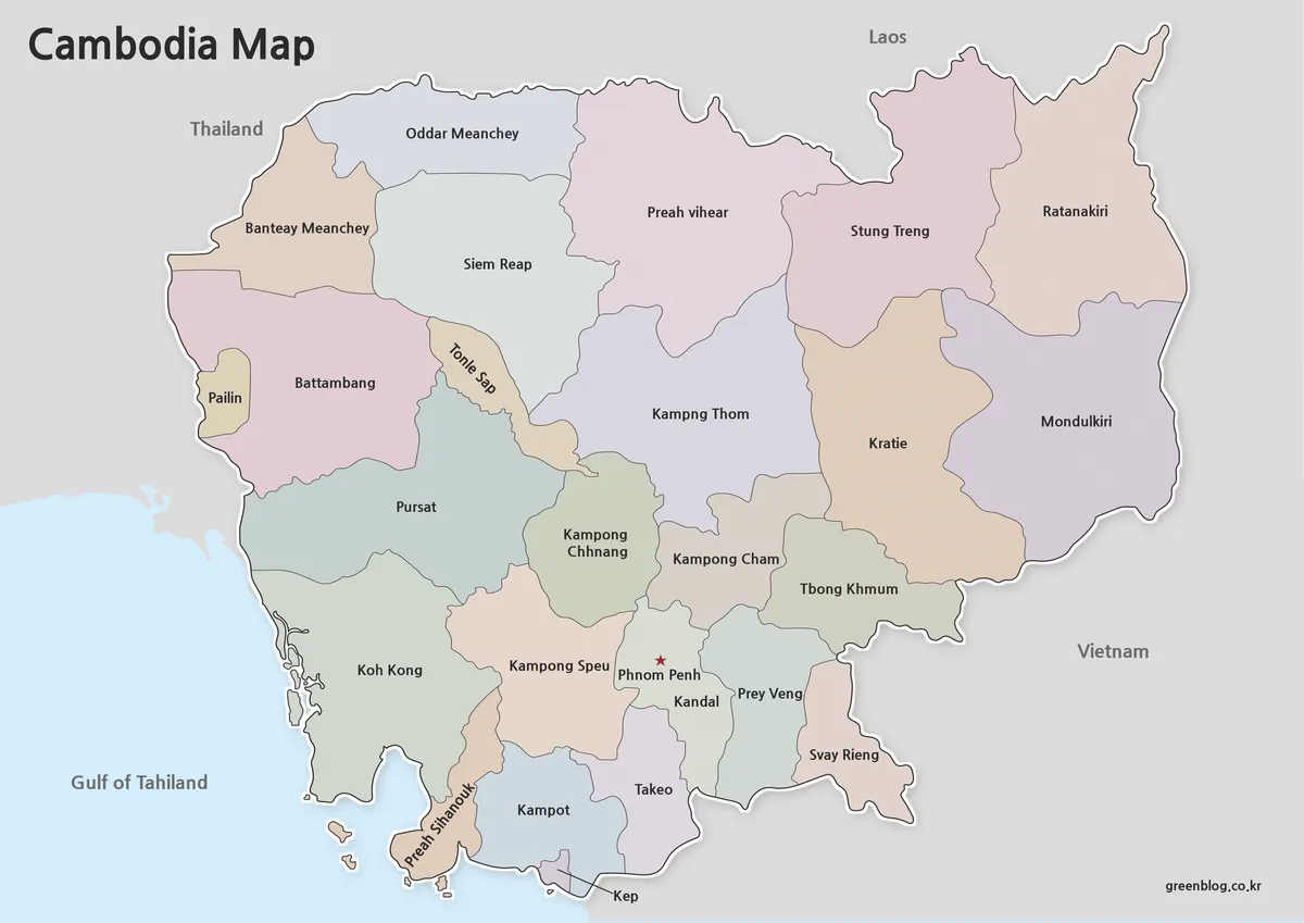
The color Cambodia Map is most useful when the reader needs to distinguish touching regions at a glance. Around Tonle Sap, Siem Reap lies to the northwest, Kampong Thom to the east, and Battambang, Pursat, and Kampong Chhnang help frame the lake from the west and south. Separate fills make this central arrangement clearer than boundary lines alone, especially on slides viewed from a distance.
The northeast has fewer, larger shapes, progressing through Preah Vihear, Stung Treng, Ratanakiri, Mondulkiri, and Kratie. By contrast, the south-central part contains compact divisions around Phnom Penh, including Kandal, Kampong Speu, Takeo, Prey Veng, and Svay Rieng. The capital appears as a small enclosed area with a red star, so it should not be mistaken for a point floating inside Kandal.
Colors carry no statistical meaning; they are simply categorical separators. The map also uses the printed form “Tbong Khmum,” while English transliterations can vary across government and reference sources. If a project requires a standardized name list, compare the supplied labels with the naming convention chosen for that project rather than silently treating color or spelling as data.
Printable Cambodia Map for Classroom and Study Use
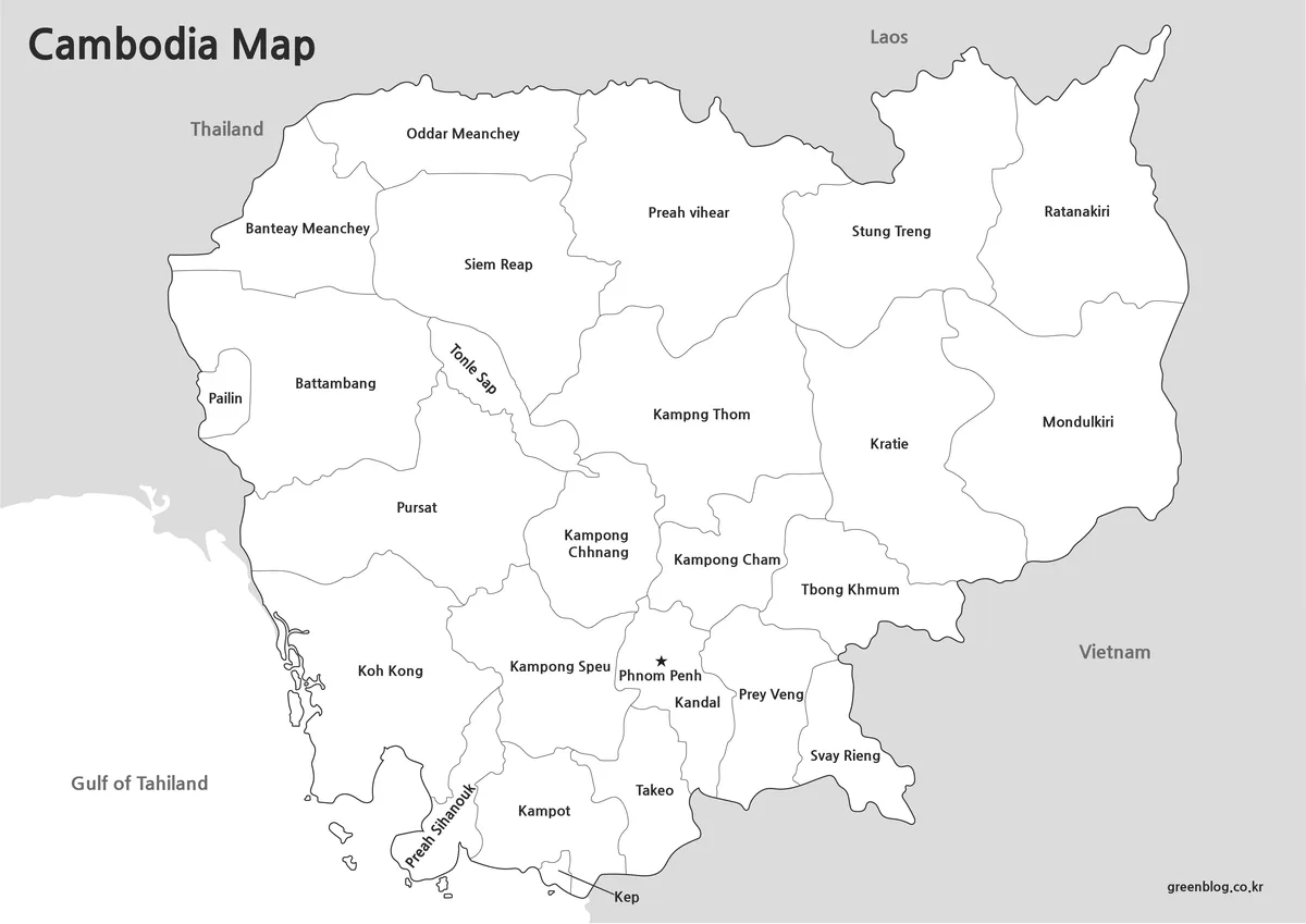
The labeled monochrome Cambodia Map keeps all 25 names, the neighboring-country labels, Tonle Sap, and the star for Phnom Penh. Its white interiors leave more room for handwritten numbers, hatching, or short notes than the pastel view. It therefore works well as an answer key, a regional reference page, or a handout where students must trace relationships without identifying every division from memory.
Print testing should focus on the smallest areas. Pailin on the western edge, Kep on the southern coast, Phnom Penh near the center-south, and the narrow coastal form of Preah Sihanouk can lose clarity if the image is reduced excessively. Maintain the landscape aspect ratio, avoid cropping the offshore shapes, and use a normal rather than aggressive toner-saving setting when thin borders are important.
The map’s heading and surrounding labels remain visible in monochrome, so the sheet can stand alone outside the article. However, there is no legend explaining the administrative level. Add a short note such as “24 provinces and Phnom Penh” when the audience may otherwise assume that the lines represent districts or a mixture of boundary types.
Blank Outline Map for Editing
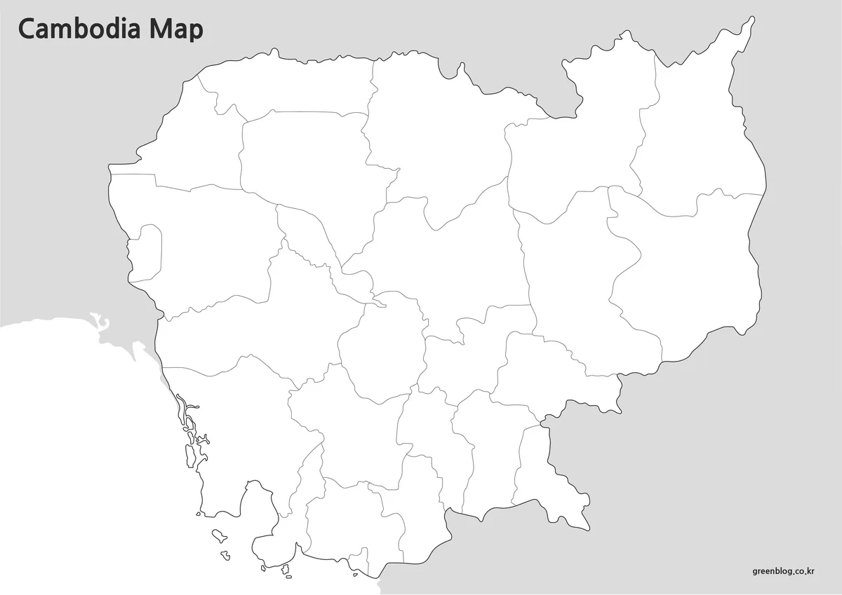
The blank Cambodia Map removes province names, country labels, the Tonle Sap label, and the red capital star. It retains the lake outline, administrative lines, coast, and surrounding gray land. This balance gives learners enough geographic structure to orient themselves while requiring them to supply the names and the location of Phnom Penh.
One effective exercise begins with the outer border: label Thailand, Laos, Vietnam, and the Gulf of Thailand, then identify the four coastal provinces. A second stage can move around Tonle Sap before filling the northeast and the dense southern group. Teachers can reserve the smallest areas—Pailin, Kep, and Phnom Penh—for a final check because they test careful observation rather than broad shape recognition.
The outline is a raster image, not a confirmed vector or layered source file. It can still accept typed labels, arrows, transparent color overlays, or numbered markers in common document and image-editing software. For a thematic activity, explain that any new colors represent the learner’s categories; the original blank file does not contain population, land-use, or economic data.
Why a Cambodia Map Is Useful
Cambodia’s outline alone does not explain how strongly Tonle Sap organizes the central map or how different the regional scales are. A labeled sheet reveals the broad northeastern provinces, the lake-facing belt, the western border group, the coastal southwest, and the compact capital region in one frame. That structure is useful in Southeast Asia lessons because the page also shows which parts meet Thailand, Laos, Vietnam, or the gulf.
For presentations, begin with the color view and use the monochrome sheet when the audience must concentrate on names rather than fills. For classroom work, pair the blank image with either labeled version as an answer key. In a report or infographic, the Cambodia Map provides a base for highlighting a selected province, but the absence of roads and rivers should be stated whenever those features matter to the discussion.
An A3 landscape page gives the long east-west form enough width while leaving space for the title and neighboring labels. Insert the image proportionally, keep a margin around the Gulf of Thailand and the northeastern tip, and confirm text size with one test print. If the finished page will be photocopied, the monochrome version generally preserves boundary contrast more predictably than converting the pastel map at the printer.
Frequently Asked Questions
Can I print the maps in A3 size?
Yes. The collection was prepared using an A3 layout and reviewed for readability at larger print sizes.
Which version is best for presentations?
The color administrative map is usually the easiest to read on presentation slides and large screens.
Is there a version for editing?
Yes. The outline map was created specifically for editing, annotation, and custom design projects.
How is Phnom Penh shown on the map?
The capital city is marked with a red star to make it easy to locate quickly.
Does the Cambodia Map show all first-level areas? Yes. The labeled views show 24 provinces plus Phnom Penh, while the blank view retains the same 25 boundaries without names. The maps do not continue into the lower district, municipality, commune, or village levels.
Map File Information
The archive contains the three Cambodia administrative views displayed above for reference, printing, labeling, and presentation work.
- Included Versions: Color labeled, black-and-white labeled, and blank outline maps
- Printable Size: A3 layout
- File Type: Image files in a ZIP archive
- Intended Use: Lessons, answer keys, reports, slides, and annotations
Related Maps
Additional Resources
The Cambodian Ministry of Tourism’s 25 destinations guide introduces Phnom Penh and every province through reader-friendly regional pages.
Green Map creates custom-edited map images using open geographic data sources such as geoBoundaries, Natural Earth, OpenStreetMap, and government open data. These maps are edited visual materials, not raw data files, and are provided for education, documents, presentations, and graphic reference.