Greene County in west-central Alabama is organized around Eutaw, but its geography is shaped just as strongly by water and relief. The Tombigbee River follows the western side, the Black Warrior River defines much of the eastern and southern edge, and a band of higher ridges crosses the northern half. Eutaw sits inland between those river corridors, with Boligee to the southwest, Union to the north, and Forkland toward the low southern river country.
You can download the Greene County Alabama map files directly from this page. The ZIP contains four original high-resolution A3 JPG maps covering the county boundary and main roads, Eutaw-centered town locations, rivers and smaller water features, and countywide elevation. The web maps below serve as previews, while the downloadable JPG files are intended for printing, school projects, presentations, and county-to-county comparisons.
Table of Contents
How Eutaw fits the county boundary and road network
Greene County lies in Alabama’s Black Belt and borders Pickens and Tuscaloosa counties on the north, Hale County on the east, Marengo County on the south, and Sumter County on the west. Its northern lines include long straight sections, while the west, east, and south are much more irregular. That contrast comes from the major rivers and connected water bodies that form or influence large parts of the outer boundary.
Eutaw, the county seat, is slightly east of the county’s center. I-20/59 crosses on a southwest-to-northeast course just north of the central city, while U.S. 11, U.S. 43, and Alabama 14 provide the more local connections through the county-seat area. This arrangement matters because an interstate can cross a county without running directly through its downtown. A traveler may use the freeway for the long approach and then rely on a U.S. or state route for the final trip into Eutaw.
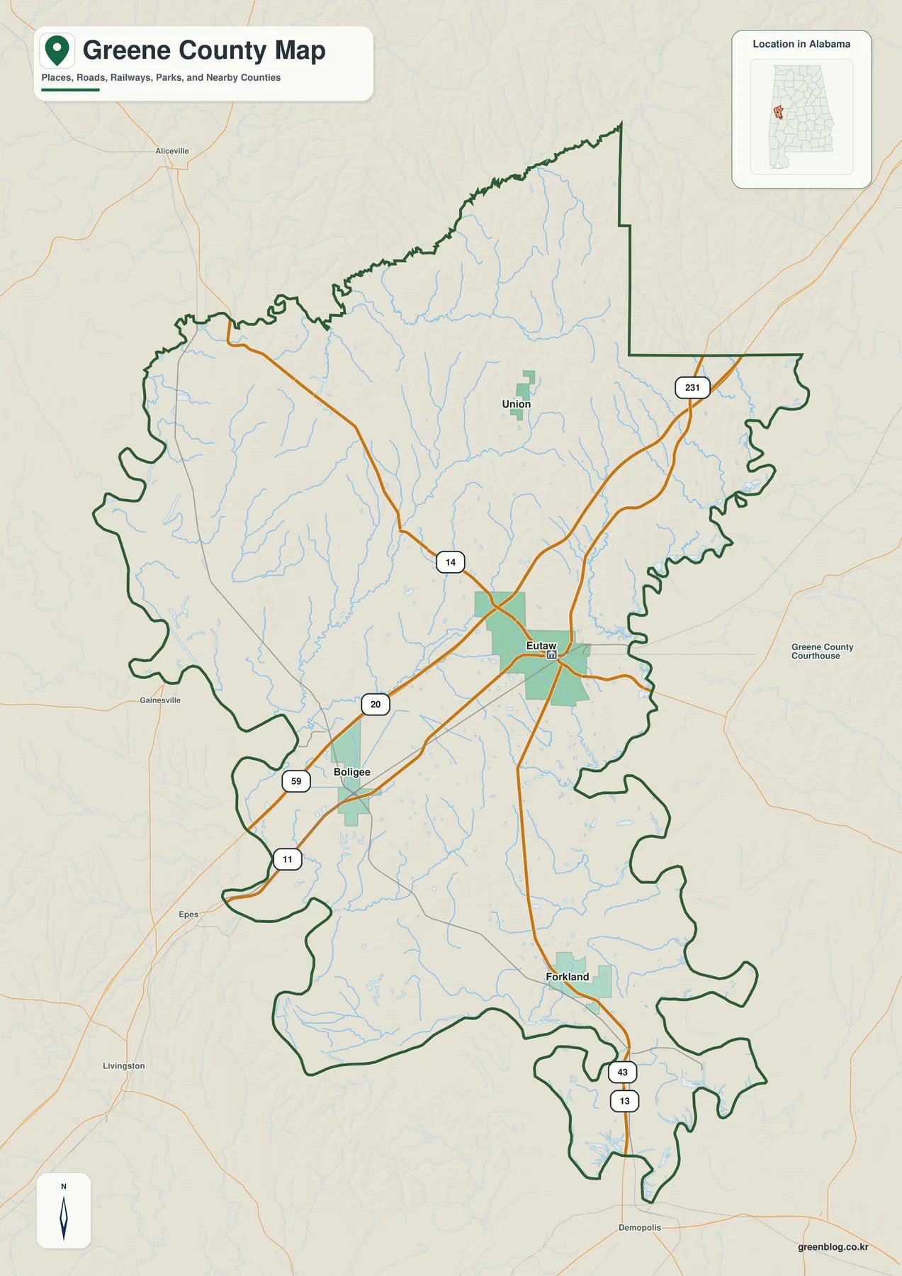
On the general county map, Eutaw stands out as the largest labeled built-up area and the point where several routes meet. Union appears north of the county seat, Boligee lies southwest, and Forkland is farther south along the route toward the Black Warrior and Demopolis area. The large spaces between these places are not empty map design; they reflect a predominantly rural county where farms, woodlands, creeks, and small communities occupy much more land than incorporated town centers.
Boligee is useful for orienting the southwestern side near the I-20/59 and U.S. 11 corridor. Forkland marks the southern part of the county, where road travel becomes closely tied to the river and reservoir landscape. Union provides a northern reference beyond Eutaw. Reading the towns by direction rather than by name alone makes it easier to remember how the county is arranged.
The outline also helps explain why neighboring places that look close in a straight line may not be reached by a direct road. River bends, tributaries, and limited crossing points can channel traffic toward specific bridges and highways. The map is therefore well suited to regional orientation, but it should not replace a current navigation map when exact driving directions are needed.
For a report or classroom display, this is the best starting map because it combines the boundary, neighboring counties, settlements, major roads, rail lines, parks, and a light water network on one page. It answers the basic questions first: where Greene County is, where Eutaw sits, and which routes connect the county to the rest of western Alabama.
From Eutaw to Boligee, Union, and Forkland
The city-connections map uses Eutaw as the hub and draws a direct line to each of the other incorporated places. Boligee is shown about 9 miles to the southwest, Union about 10 miles to the north, and Forkland about 14 miles to the south. These are straight-line distances between reference points, not road mileage, so they describe relative position rather than a turn-by-turn trip.
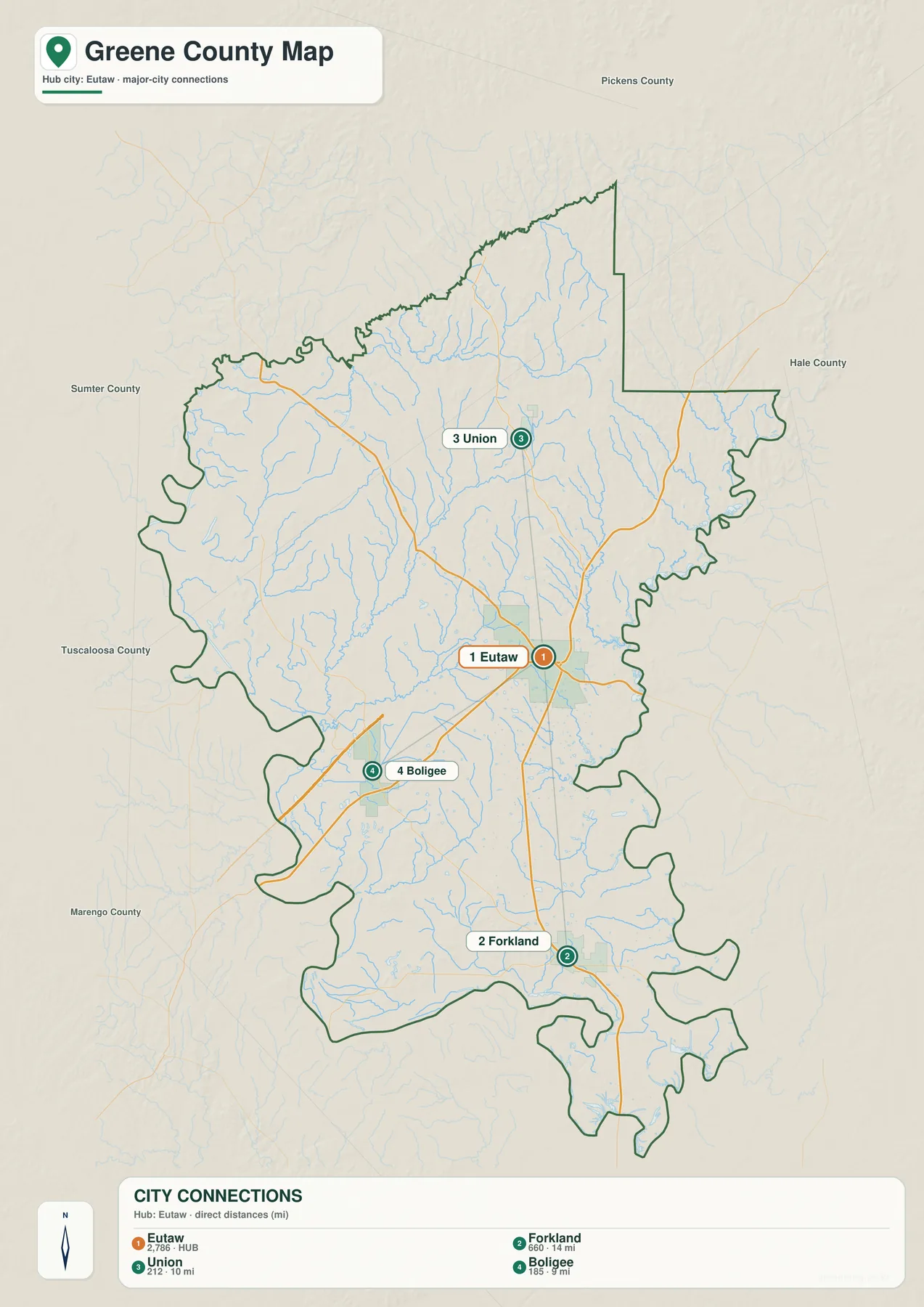
The diagram makes the county’s settlement pattern easier to grasp than a population list would. Eutaw occupies the central service role, while the other towns sit in three different directions across a broad rural area. No continuous urban belt joins them. Instead, highways and county roads cross farmland, forest, stream valleys, and low river country before reaching the next incorporated place.
Boligee is the closest connection in the diagram. Its southwestern position makes it a useful marker for the Tombigbee side and the approach from Sumter County. Union is only slightly farther in straight-line terms, but it represents a very different part of the county: the northern interior, where ridges and tributaries are more prominent. Forkland is the farthest of the three and belongs to the southern landscape near the Black Warrior–Tombigbee confluence and Demopolis Lake.
Road mileage can exceed the values printed on the map because roads do not follow the connector lines. A route may bend around a creek, use a specific bridge, or follow a highway that approaches a town from another direction. The city diagram is most useful for answering “Which way is it from Eutaw?” and “Which town is relatively closest?” For travel time, road conditions, and exact mileage, use an up-to-date navigation source.
The map also prevents a common misunderstanding about place labels. Greene County contains many named rural communities, but Eutaw, Boligee, Forkland, and Union are the incorporated municipalities represented in this city comparison. Other labels on a detailed base map may be locally important without having the same municipal status.
Rivers, creeks, lakes, and the low ground between them
Water is the strongest natural feature in Greene County. The Tombigbee River runs along the western side, while the Black Warrior River follows much of the eastern edge and turns through the southern area. The two systems meet near Demopolis just beyond the county. As a result, Forkland and the southern boundary belong to a much larger river-and-reservoir setting rather than to a simple inland creek network.
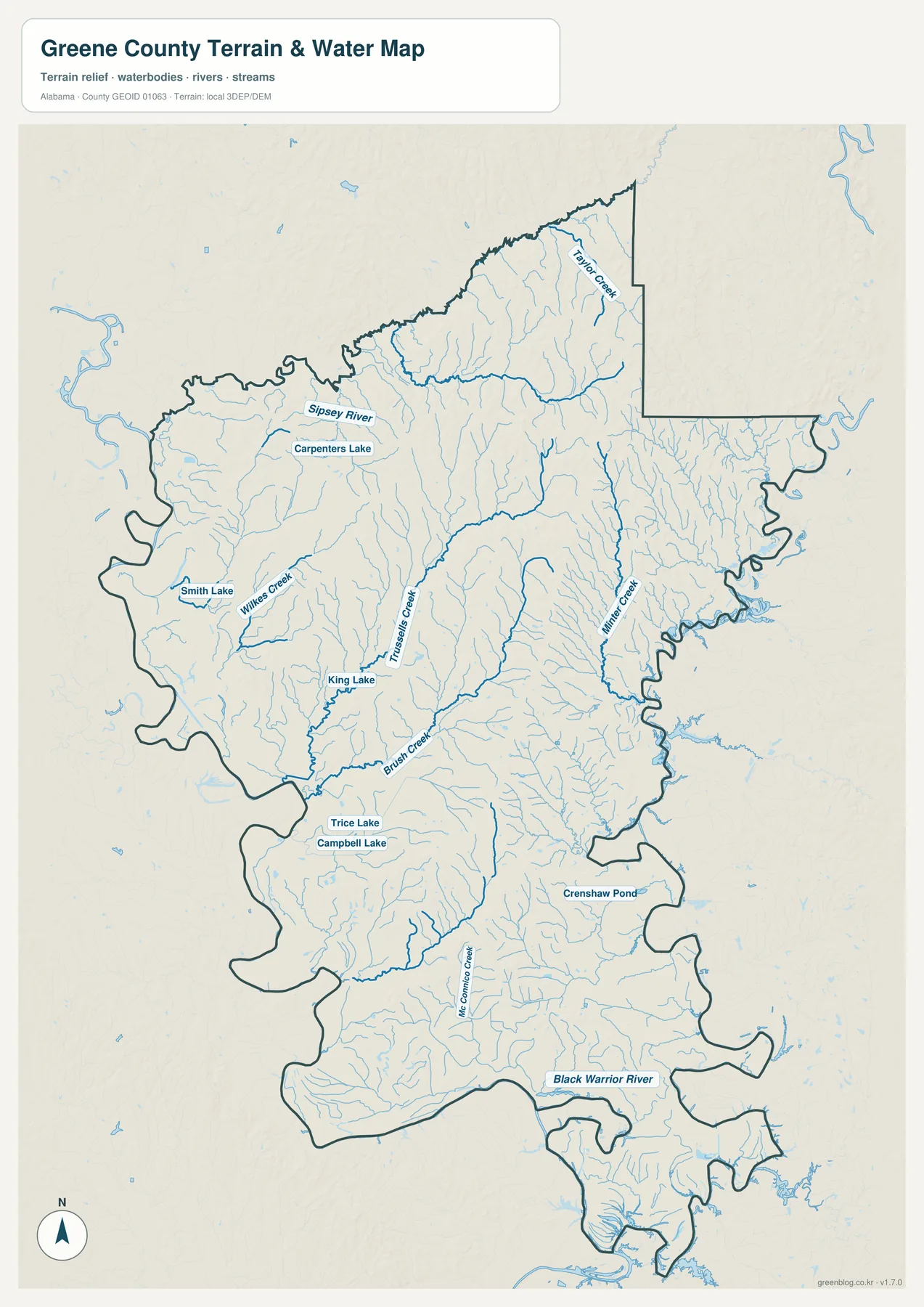
The northern map area includes the Sipsey River and Taylor Creek. Farther south and west, Wilkes Creek, Brush Creek, and numerous unnamed tributaries descend through the interior. Millner Creek and other eastern channels run toward the Black Warrior side. The fine blue lines branch through nearly every part of the county, showing that the large boundary rivers collect water from many smaller valleys.
Several named lakes and ponds provide useful local reference points. Carpenters Lake, Smith Lake, King Lake, Trice Lake, Campbell Lake, and Crenshaw Pond appear among the tributaries. They are much smaller than the managed river lakes near Demopolis, but they help identify where water spreads into broader depressions or remains behind natural and constructed controls.
The map is easiest to read from the small streams outward. Begin with a thin upper branch, follow it downhill into a larger creek, and then continue toward the Tombigbee or Black Warrior system. This approach explains why the northern ridges contain many narrow drainage valleys and why the southern part of the county has broader, more interconnected lowlands.
Waterways also help explain the road pattern. Major roads generally use favorable terrain and a limited number of crossings rather than cutting straight across every stream valley. In a low-density rural county, a bridge location can matter more than the apparent closeness of two points on a page. That is one reason the city-map connectors should never be mistaken for drivable routes.
This is a geographic water-reference map, not a flood-insurance, parcel, boating, or legal-navigation product. It shows the relative locations of rivers, creeks, lakes, and ponds at county scale. Flood risk, public access, boating rules, and current water conditions require the appropriate agency’s detailed and current information.
Where northern ridges give way to southern river lowlands
The elevation map reveals more relief than the general basemap suggests. Its legend spans roughly 22 to 134 meters, with a countywide mean near 52 meters. Greene County is not mountainous, but the difference between narrow upland ridges and broad river lowlands is large enough to shape streams, roads, and the appearance of the landscape.
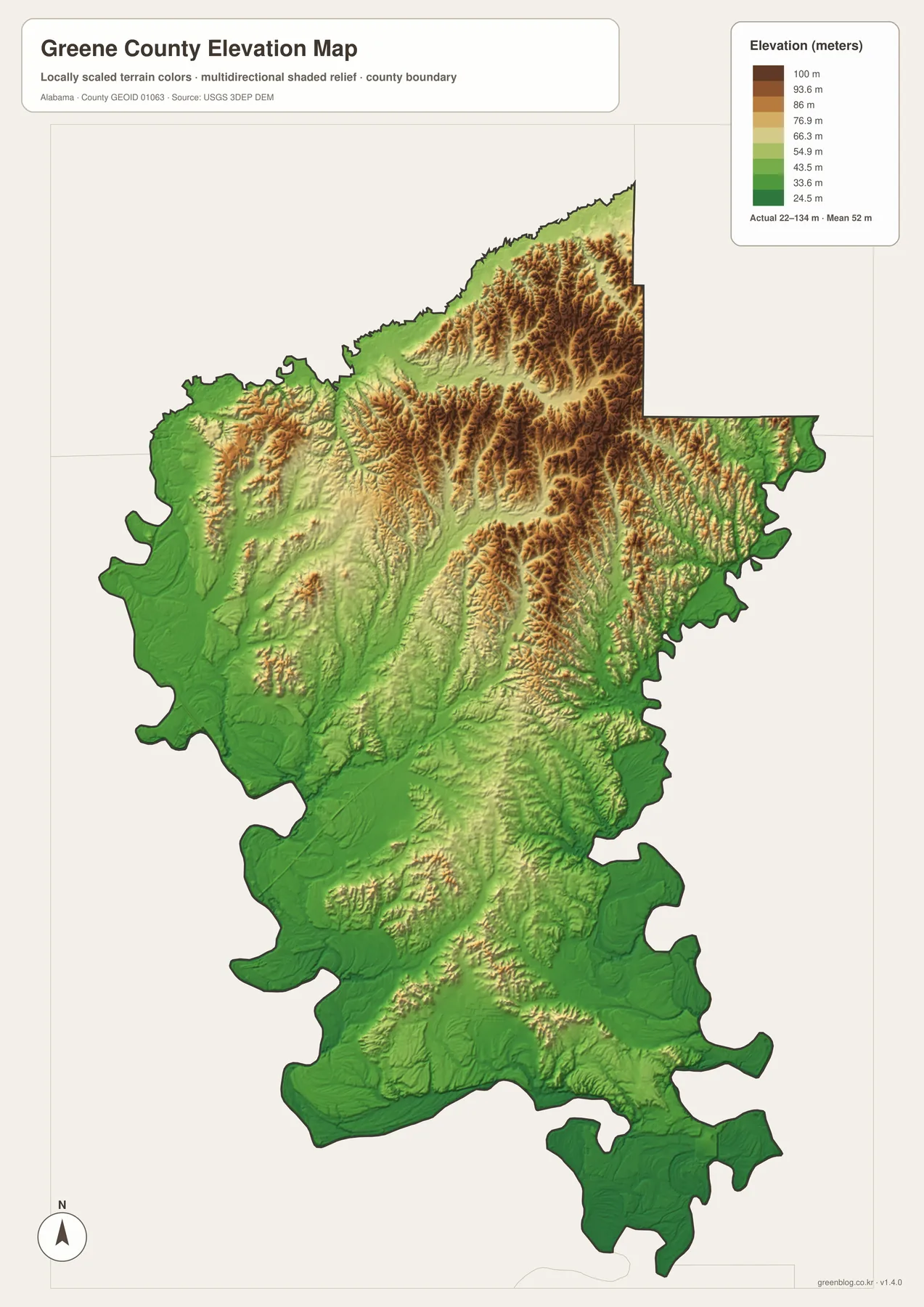
The highest-looking terrain is concentrated in the north and northeast, where closely spaced brown ridges are cut by narrow green valleys. Similar but smaller ridge bands extend through parts of the east-central interior. The western edge and much of the south remain greener, indicating lower and generally smoother ground near the Tombigbee, Black Warrior, and their connected lowlands.
When the elevation and water maps are compared, many stream lines fall into the green channels between ridges. The relationship is especially clear in the northern half, where short tributaries begin on higher ground and merge as they descend. Toward the south, valleys widen and the drainage network approaches the large river system around Forkland and Demopolis.
Relief also adds context to road and settlement placement. Routes tend to follow manageable grades, valley openings, or established crossings instead of repeatedly climbing the steepest ridge faces. Eutaw occupies an inland position between the largest rivers, while the southern communities and roads encounter broader low terrain and more complicated water edges.
The colors and hillshade are generalized for a countywide view. They are appropriate for comparing high and low areas, identifying ridge belts, and illustrating how drainage follows valleys. They are not survey measurements for a parcel, and they should not be used by themselves for engineering, construction, drainage design, or property decisions.
Why the county seat moved inland to Eutaw
Greene County was formed in 1819 and named for Nathanael Greene, a general in the American Revolution. Its first county seat was Erie near the Black Warrior River. Flooding and yellow-fever concerns contributed to the decision to move the seat to Eutaw in 1838. The current map gives that history a clear geographic setting: the administrative center was moved away from a boundary river to a more central inland location.
Eutaw was earlier known as Mesopotamia and later took its present name from the Battle of Eutaw Springs. During the nineteenth century, it developed as a legal and commercial center for the surrounding Black Belt countryside. Today it remains the point where county government, local services, and the most visible road connections are concentrated.
The Black Belt is known for its dark soils, agricultural history, broad rural tracts, and widely spaced communities. Greene County’s maps reflect those characteristics. The incorporated places are small and separated, the road network is selective rather than dense, and natural features occupy a large share of the page. The rivers are not decorative edges; they influenced settlement, transportation, and the location of the county seat.
Taken together, the four maps tell one connected story. The boundary map establishes the administrative frame and roads. The city diagram shows how the towns are distributed around Eutaw. The water map fills in the tributaries and lakes that shape local access, while the elevation map explains why those streams occupy particular valleys. Each map adds information that the others intentionally leave out.
Selecting a map for print, study, or comparison
Choose the general county map when the task requires the county outline, neighboring counties, Eutaw, the incorporated places, and major routes on a single page. It works well as the opening figure in a report, a classroom location map, or a visual reference when comparing Greene County with other Alabama counties.
Use the city-connections map when relative direction is more important than background detail. Its Eutaw-centered design makes the settlement pattern immediately visible and keeps the straight-line measurements easy to read. For river studies, environmental lessons, or a discussion of county boundaries, the water map provides the clearest stream and lake detail. The elevation map is the better choice for explaining ridges, valleys, and the transition into southern lowlands.
- County boundary, neighboring counties, towns, and major roads: county map
- Directions and straight-line distance from Eutaw: city-connections map
- Rivers, tributary creeks, lakes, and ponds: water map
- Countywide relief from about 22 to 134 meters: elevation map
The original files are sized for A3 output, so labels and terrain detail remain easier to read than they would in a small web preview. They may be reduced for letter-size or presentation use, but check the smallest labels before printing. These maps are designed for geographic explanation and visual reference; current navigation, flood, parcel, and engineering work should use the appropriate specialized sources.
Frequently Asked Questions
Why does the Greene County boundary look so irregular on the west and south?
Large parts of the outer edge follow the Tombigbee and Black Warrior river systems. Rivers bend, split around lowlands, and widen into managed water bodies, so a boundary tied to those waterways cannot remain straight. The contrast is easy to see against the longer straight segments in the north.
Why are the city-map distances different from driving mileage?
The labels measure straight-line distance from Eutaw to Boligee, Union, and Forkland. Roads must follow available bridges, grades, and established routes, so the trip by car can be longer. Use the diagram to compare direction and relative proximity, then consult a current road source for travel planning.
Can the elevation map be used for surveying or construction?
No. The map generalizes a countywide elevation surface to show the broad difference between ridges, valleys, and river lowlands. It does not provide parcel-level accuracy or replace a field survey. Engineering, construction, and drainage decisions require detailed official data and professional measurement.
Map File Information
Greene County map files
- Included Files: 4 high-resolution A3 JPG maps
Related Maps
Sources and reference data
The following sources provide background on Greene County and the public boundary, road, water, and elevation datasets used for county-scale map work. Consult the linked pages directly when a project requires the newest release or more detailed documentation.
- Encyclopedia of Alabama: Greene County
- Encyclopedia of Alabama: Eutaw
- Alabama Department of Transportation Highway Functional Classification Maps
- U.S. Census Bureau TIGER/Line Shapefiles — county boundary reference data.
- USGS National Hydrography — river and stream reference data.
- USGS 3D Elevation Program — elevation reference data.
- Alabama Population Density Map: Urban Clusters, County Totals and a Decade of Change
- Greene County Alabama Land Cover Map | Wetlands, Forest & Four JPGs
Green Map creates custom-edited map images using open geographic data sources such as geoBoundaries, Natural Earth, OpenStreetMap, and government open data. These maps are edited visual materials, not raw data files, and are provided for education, documents, presentations, and graphic reference.