Hale County in west-central Alabama stretches from the Tuscaloosa-facing community of Moundville in the north to a much more rural southern half centered on Greensboro and Newbern. The county seat, Greensboro, provides the main administrative reference point, but the map becomes more useful when the Black Warrior water system and the contrast between low western river country and higher eastern ridges are considered at the same time.
You can download the Hale County Alabama Map files directly from this page. The ZIP contains four original high-resolution A3 JPG maps: a county map with roads and places, a Moundville-centered city connection map, a waterways map, and an elevation map. The web images below are previews, while the larger JPG files are better suited to printing, classroom work, presentations, county comparisons, and personal reference.
Table of Contents
Greensboro, the county boundary, and the main road pattern
Hale County is part of Alabama’s Black Belt. It borders Tuscaloosa County to the north, Bibb County to the northeast, Perry County to the southeast, Marengo County to the south, and Greene County to the west. The outline is not equally simple on every side. Long sections of the eastern boundary are comparatively straight, while the western edge bends repeatedly around river and lowland features.
Greensboro sits slightly east of the county’s center and serves as the county seat. Alabama 69 connects the county-seat area with Moundville to the north, while Alabama 14 provides an important cross-county route through Greensboro. Newbern lies southeast of Greensboro along Alabama 61. These roads do not form a dense urban grid; instead, they link a small number of communities across broad rural spaces.
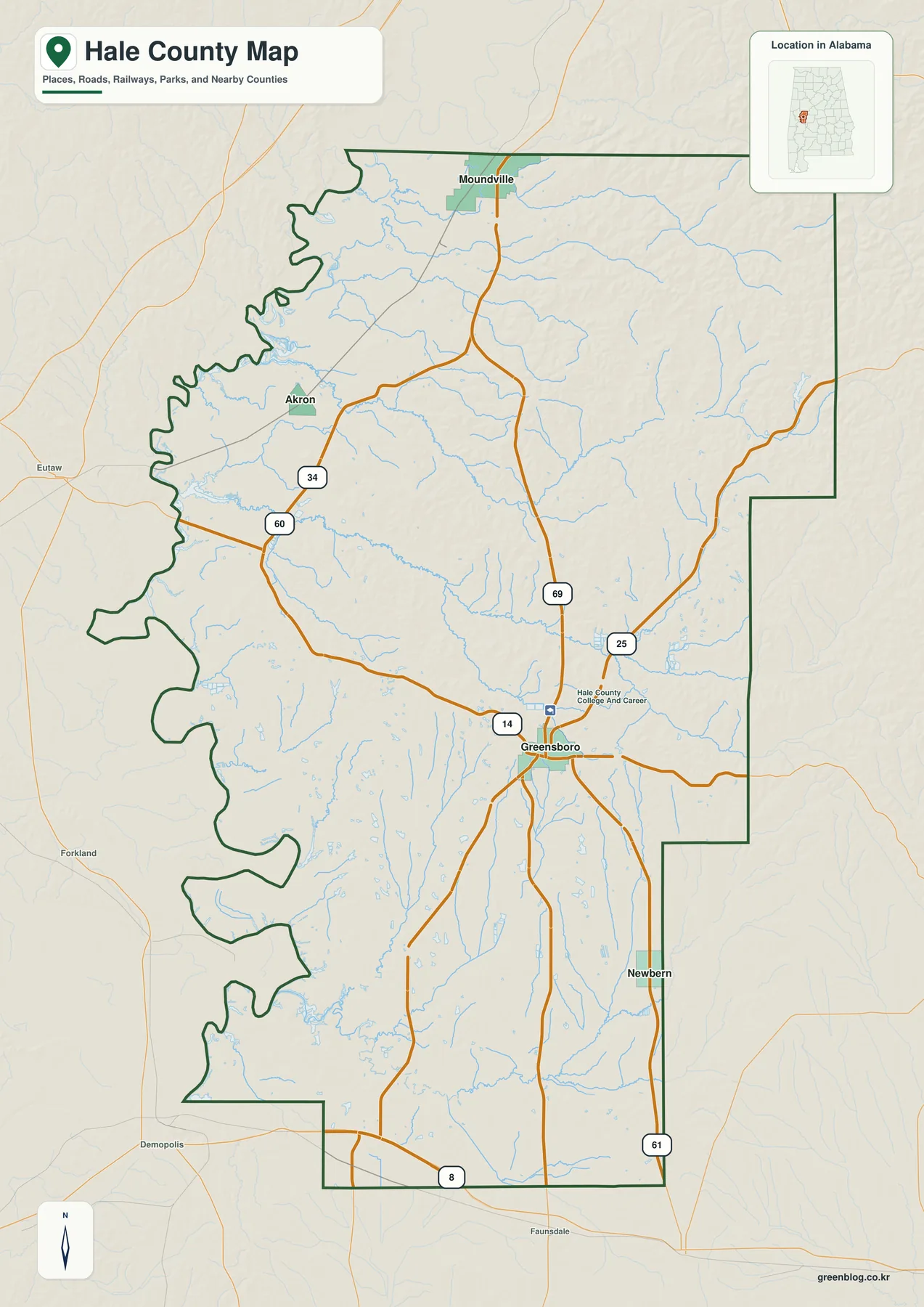
Moundville is close to the northern boundary and has the strongest geographic connection to the Tuscaloosa side of the county. Akron is a smaller northwestern reference point toward the Greene County side. Newbern occupies a different setting southeast of Greensboro, away from the northern urban influence. Taken together, the four labels make it easy to divide Hale County into recognizable directions without filling the map with every small rural community.
The general map is best used for regional orientation rather than turn-by-turn driving. It shows where the principal places sit, which direction the major routes run, where streams begin to influence the landscape, and why the western boundary is so irregular. For a report or classroom display, it is the strongest first map because it establishes the county’s overall shape before the more specialized water and terrain maps add detail.
Hale County covers 643.99 square miles of land, and the source material reports a 2020 population density of 23.0 people per square mile. That low density helps explain the large gaps between incorporated places. Roads and bridges matter greatly because many residents live outside the main town centers, and a short-looking straight-line distance may translate into a longer route on the ground.
Why the city map uses Moundville as its hub
The city connection map deliberately uses Moundville as the hub, even though Greensboro is the county seat. That design choice does not assign Moundville an administrative role. It simply provides a northern reference point from which the other labeled communities can be compared by direction and straight-line distance. Because Hale County extends a long way south from Moundville, the arrangement makes the north-to-south spacing especially easy to see.
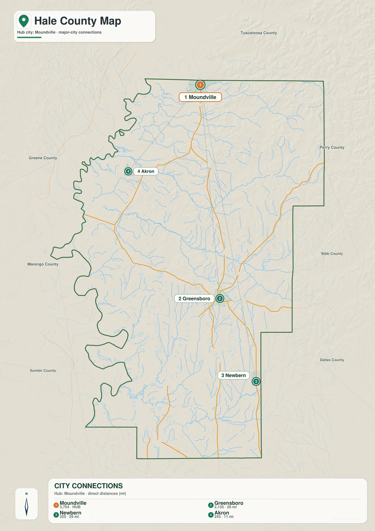
Akron is the nearest of the three connections shown, about 11 miles from Moundville in a straight line. Greensboro is about 20 miles away, farther south in the county’s central service area, while Newbern is about 29 miles from the hub toward the southeast. These measurements are not driving mileage. Roads must follow available crossings, established routes, and local terrain, so a trip by car may be longer than the number printed on the diagram.
The directional pattern is more important than the exact mileage. Moundville represents the northern side and the approach toward Tuscaloosa. Akron provides a northwestern rural reference, Greensboro anchors the middle of the county, and Newbern marks the southeastern interior. This simple arrangement is useful when a reader needs to remember where the main communities are before looking at a more detailed road source.
Other places exist between these labels. The supplied Hale County material mentions communities such as Sawyerville, Gallion, Havana, and Stewart, which help fill the large rural spaces between the incorporated municipalities. The connection map does not attempt to rank or display every settlement. Its purpose is narrower: compare a few major reference points without losing them in a dense collection of local names.
Creeks, ponds, and the water network toward Lake Demopolis
The water map reveals far more drainage detail than the general county map. Numerous small streams begin across the north and east, descend through local valleys, and join larger channels toward the west and southwest. The pattern helps explain both the irregular county edge and the broad low areas that appear in the elevation map. Water is not confined to one large river line; it is spread through a dense branching network.
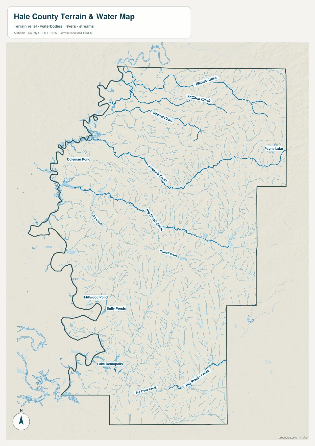
In the northern part of the map, Elliotts Creek, Millians Creek, and Gabriel Creek provide clear named examples. Fivemile Creek and Big Brush Creek cross the central portion, while Colwell Creek and Big Prairie Creek appear farther south. Many thinner unnamed branches feed these channels. The result is a landscape divided into a large number of small valleys rather than one broad, flat drainage plain.
The map also labels several standing-water features. Payne Lake appears on the eastern side, Coleman Pond is farther west in the northern half, and Millwood Pond and Sully Ponds sit in the southwest. Lake Demopolis is shown near the southwestern edge. These features vary greatly in size, so they should not be treated as equivalent lakes; their value here is to show where water collects and how those locations relate to nearby streams and low ground.
The supplied background material connects Hale County’s western geography with the broader Black Warrior–Tombigbee waterway system. Managed pools such as Warrior Lake and the upper reaches of Demopolis Lake widen parts of the river corridor and contribute to the indented shape of the western and southwestern boundary. That geography also limits the number of direct crossings, which is one reason straight-line proximity does not always predict easy road access.
This is a county-scale water reference, not a flood-hazard, navigation, or property map. It can help explain stream location, drainage direction, and the relationship between water and the county outline. Decisions involving flood insurance, boating rules, parcel boundaries, or engineering should be based on the current specialized information from the responsible agency rather than on this overview map.
From about 22 to 178 meters: western lowlands and eastern ridges
The elevation map reports an actual countywide range of about 22 to 178 meters, with a mean near 63 meters. Those numbers are modest compared with Alabama’s mountain counties, yet the shaded relief shows substantial local variation. Low green terrain dominates much of the western side, while higher yellow, tan, and brown ridges become more common across the east and northeast.
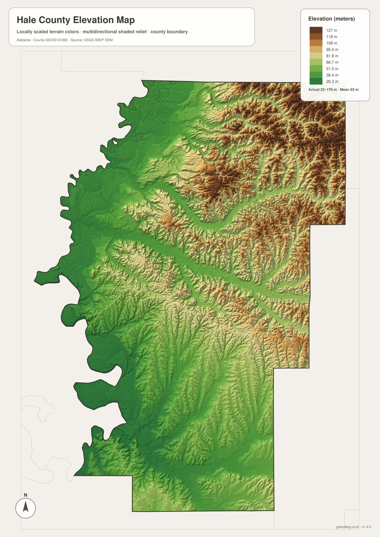
The eastern half is the most textured part of the image. Short ridges and narrow valleys repeat across a broad area, producing a much rougher surface than the low western river country. Green valley bands cut through some of these higher zones, matching the drainage corridors visible on the water map. The two maps therefore reinforce each other: streams occupy lower routes through terrain that rises on either side.
Western Hale County is generally lower and smoother, especially near the larger water system. That does not mean every western point has the same elevation, but the broad contrast is clear at county scale. The central and eastern parts include more pronounced relief, which is useful when explaining why drainage lines branch so frequently and why local roads may curve around valleys rather than following an ideal straight route.
The elevation colors are intended for relative visual comparison. They do not replace survey-grade elevations, engineering measurements, or parcel-level topographic data. For a school project, regional presentation, or county comparison, the map is excellent for showing the main terrain difference. For construction, drainage design, or precise elevation work, a more detailed dataset and professional measurement are required.
Two small places with outsized local significance
Hale County was established on January 30, 1867, and Greensboro became the county seat. The county lies within the historic Black Belt, where fertile soils strongly influenced nineteenth-century agriculture and settlement. That background helps explain the broad rural landscape seen between the present-day towns, but two places—Moundville and Newbern—add unusually distinctive layers that a simple road map cannot convey by label size alone.
South of the town of Moundville, Moundville Archaeological Park occupies a 326-acre site near the Black Warrior River. The source material describes 29 large flat-topped mounds arranged around a central plaza and identifies the site as a major Mississippian population and ceremonial center about 800 years ago. The river setting mattered long before modern highways, and it remains a useful reminder that northern Hale County has been tied to the Black Warrior corridor for centuries.
Newbern tells a much more recent story. Auburn University’s Rural Studio has been based in Hale County since 1993, with its headquarters in Newbern. The program has completed more than 200 projects across the Black Belt, including housing and civic work. Town Hall, Firehouse, Library, and other projects give the small community a role in contemporary rural architecture that is far larger than its population would suggest.
Rural Studio projects also appear in Greensboro, creating a modern connection between the county seat and Newbern. Moundville, by contrast, combines present-day access toward Tuscaloosa with a much older archaeological landscape on the Black Warrior. Considering those two places alongside the maps turns Hale County from a collection of road labels into a county with very different northern, central, and southeastern identities.
Choosing the right Hale County map for your project
Use the general county map when the boundary, Greensboro, neighboring directions, and main roads matter most. Choose the city connection map when you need a simple comparison of Moundville, Akron, Greensboro, and Newbern. The water map is better for creeks, ponds, Lake Demopolis, and drainage relationships, while the elevation map is the clearest choice for explaining the contrast between the low western corridor and the more rugged eastern half.
- County boundary, Greensboro, main roads, and regional orientation: county map
- Direction and straight-line distance from Moundville to Akron, Greensboro, and Newbern: city map
- Named creeks, ponds, lakes, and drainage toward larger western waters: waterways map
- Countywide relief from about 22 to 178 meters: elevation map
The downloadable originals are sized for A3 output, so labels and relief detail remain easier to read than they do in a small browser preview. You can reduce them for a smaller page or presentation slide, but check the smallest labels before printing. The four files are designed as complementary references; using the map that matches the question usually produces a cleaner result than trying to place roads, towns, water, and terrain on one crowded image.
Frequently Asked Questions
Why is Moundville the hub on the city map instead of Greensboro?
The city diagram uses Moundville only as the reference point for direction and straight-line distance. Greensboro remains the county seat. Because Moundville sits near the northern edge, using it as the hub makes the spacing of Akron, Greensboro, and Newbern down the length of Hale County especially easy to compare.
Why is the western Hale County boundary so irregular?
Much of the western side is influenced by the Black Warrior–Tombigbee water system, including broad river and reservoir reaches. Waterways bend and widen rather than following straight survey lines, so the county edge develops deep curves and indentations. The general map and water map show the same relationship from different levels of detail.
What is the main feature to notice on the Hale County elevation map?
The map reports an actual range of about 22 to 178 meters and a mean near 63 meters. The broad western river country is generally lower, while the east and northeast contain more closely spaced ridges and valleys. That west-to-east terrain contrast is more useful at county scale than any single elevation number.
Map File Information
Hale County map files
- Included Files: 4 high-resolution A3 JPG maps
Related Maps
Sources and reference data
The following sources provide the county background and public road, water, and elevation references included in the supplied Hale County material. When a project requires the newest statistics, regulations, or detailed technical data, consult the linked source directly.
- Encyclopedia of Alabama: Hale County — county history and regional context.
- University of Alabama: Moundville Archaeological Park — Moundville site background and Black Warrior River setting.
- ALDOT Survey Mapping — county and municipal road-map references.
- U.S. Army Corps of Engineers: Black Warrior–Tombigbee Lakes — regional reservoir and waterway context.
- Auburn University Rural Studio — Newbern-based program background.
- USGS 3D Elevation Program — elevation-data reference.
- Alabama Population Density Map: Urban Clusters, County Totals and a Decade of Change
- Hale County Alabama Land Cover Map: Northern Forest, Wet Corridors and Southern Farms
Green Map creates custom-edited map images using open geographic data sources such as geoBoundaries, Natural Earth, OpenStreetMap, and government open data. These maps are edited visual materials, not raw data files, and are provided for education, documents, presentations, and graphic reference.