A Texas map is useful whenever you need to explain the scale, location, or regional structure of one of the largest states in the United States. Texas sits in the south-central part of the country, bordered by New Mexico, Oklahoma, Arkansas, Louisiana, and Mexico. Because the state covers such a large area, a clear visual map is often easier to understand than a written explanation, especially when comparing Texas with other U.S. states or nearby regions.
This printable Texas map collection includes three versions: a color county map, a black and white labeled map, and a blank outline map. The files were prepared in JPG format at A3 high-resolution size, making them suitable for classroom handouts, presentation slides, blog graphics, printable study materials, and editable design work. The collection was made for users who need a practical visual reference rather than a crowded atlas-style map.
Texas has several major urban areas spread across a wide region, including Houston, Dallas, Fort Worth, San Antonio, and Austin. This distributed layout is one reason a Texas map is so helpful for education and presentation work. City locations, county boundaries, and regional relationships become much easier to explain when they are shown visually.
During the map preparation process, county boundary readability was checked at larger print sizes. The layout was also reviewed in reduced-size previews so that major cities and boundary lines remain visible when inserted into slides or documents. Since some public map images become difficult to read after resizing, this version was arranged with printing and screen visibility in mind.
Table of Contents
Texas Map File Overview
This map set was prepared for users who need different visual styles for different projects.
- Main uses: Printing, education, presentations, editing, infographic design
- Region: Texas, United States
- Capital: Austin
- File format: JPG
- Image size: A3 high resolution
- Color mode: CMYK
Included versions: Color map / black and white map / outline map
Color Texas Map for Regional Comparison
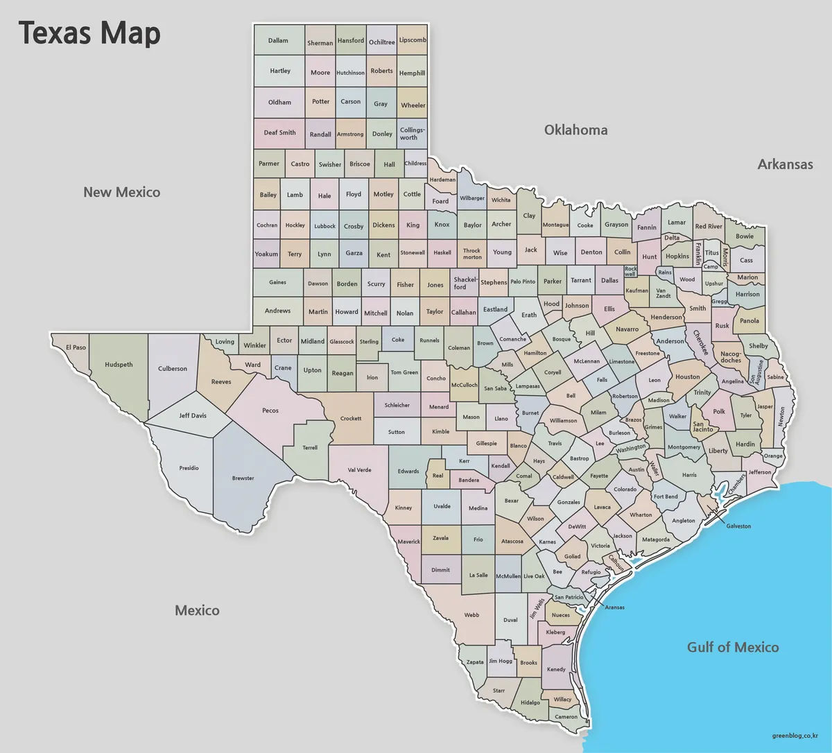
The color Texas map is designed for quick visual understanding. County areas are separated with color, making it easier to identify regional divisions across the state. This version works well for geography lessons, state comparison materials, blog posts, and presentation slides where viewers need to understand the layout quickly.
Because Texas is large and its major cities are spread out, color separation helps reduce visual confusion. It is especially useful when explaining the Houston area, Dallas–Fort Worth, Austin, San Antonio, or broader south-central U.S. geography. The colors were adjusted to remain clear on screen while still being comfortable for printed materials.
Black and White Texas Map for Documents
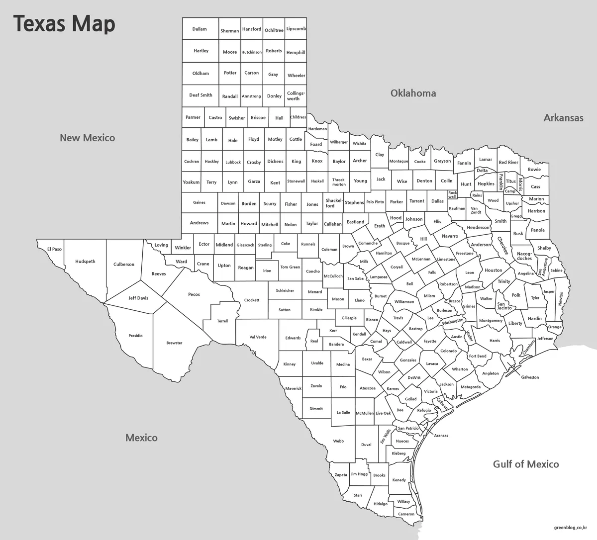
The black and white Texas map focuses on labels and boundary lines. It is a cleaner option for reports, worksheets, handouts, and reference documents where color is not needed.
This version was reviewed with monochrome printing in mind. Line thickness and text size were adjusted so that the map remains readable when printed or reduced. It also leaves more visual space for notes, arrows, highlights, or additional information.
For classroom worksheets or document inserts, the black and white version is often the most practical choice.
Texas Outline Map for Editing
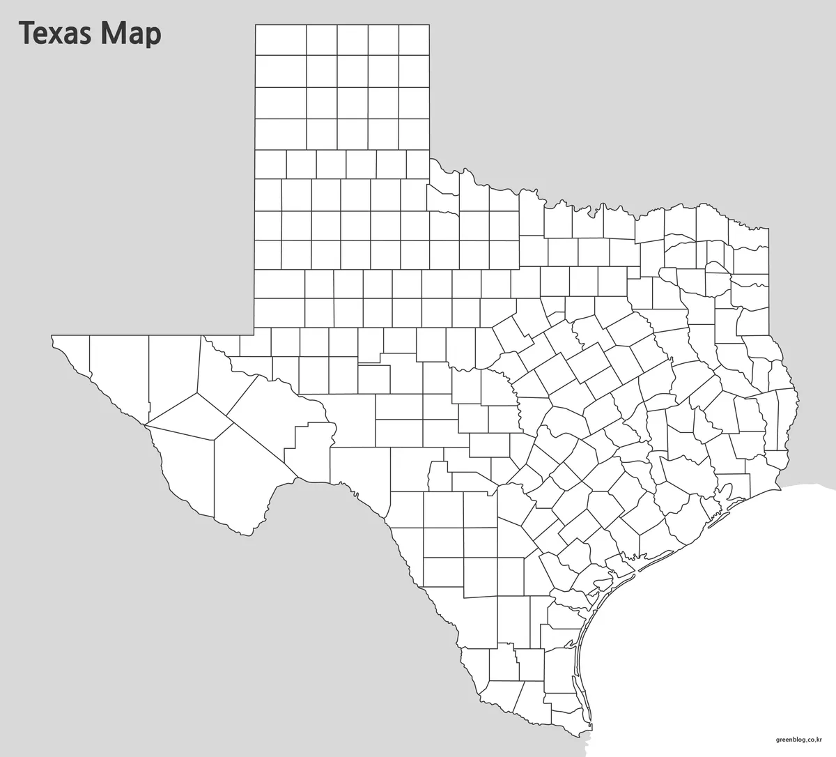
The Texas outline map removes labels and colors, leaving a clean boundary structure. This blank version is useful for editing, coloring, infographic projects, and custom map design.
Teachers can use it for classroom activities, while designers can add icons, routes, data points, or highlighted regions. It also works well for travel route illustrations, county comparison graphics, logistics maps, and presentation backgrounds.
During preparation, boundary lines were simplified for easier editing in graphic software. The goal was to keep the map clean enough for customization while still preserving the recognizable shape and county structure of Texas.
When a Texas Map Is Useful
A printable Texas map can be helpful in many situations:
- U.S. state comparison projects
- Classroom geography lessons
- Travel route presentations
- Blog and website graphics
- Infographic design
- County-based study materials
- Business or logistics presentations
- Printable worksheets
Texas is often used as an example when explaining large U.S. states, southern geography, population centers, and regional travel routes. A well-organized map makes those explanations easier to follow.
Frequently Asked Questions
Can I print the Texas map on A4 paper?
Yes. The files were prepared for A3 size, but they can also be scaled down to A4 for classroom or document use.
Which Texas map version is best for presentations?
The color map is usually the easiest to read in slides because county areas are visually separated.
Is the outline map editable?
Yes. The blank outline version is suitable for coloring, annotations, and graphic editing.
Which version should I use for worksheets?
The black and white map is best for worksheets, handouts, and printed study materials.
Texas Map Download
Choose the Texas map version that fits your project. Printable, labeled, and editable-style map files are included for education, presentations, and design work.
- File Format: JPG
- Image Size: A3 High Resolution
- Color Mode: CMYK
- Usage: Printing, Education, Presentations, Editing
Additional Resources
- USGS National Map – Official U.S. map service providing geographic and topographic map data for national and state-level reference.
Related Maps
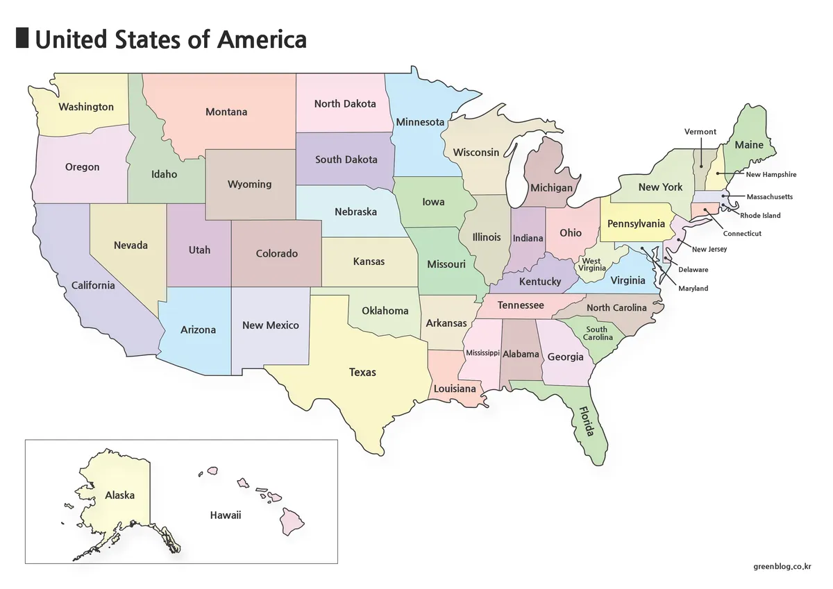
- 5 United States Maps for Download (Color, Black & White, Outline)
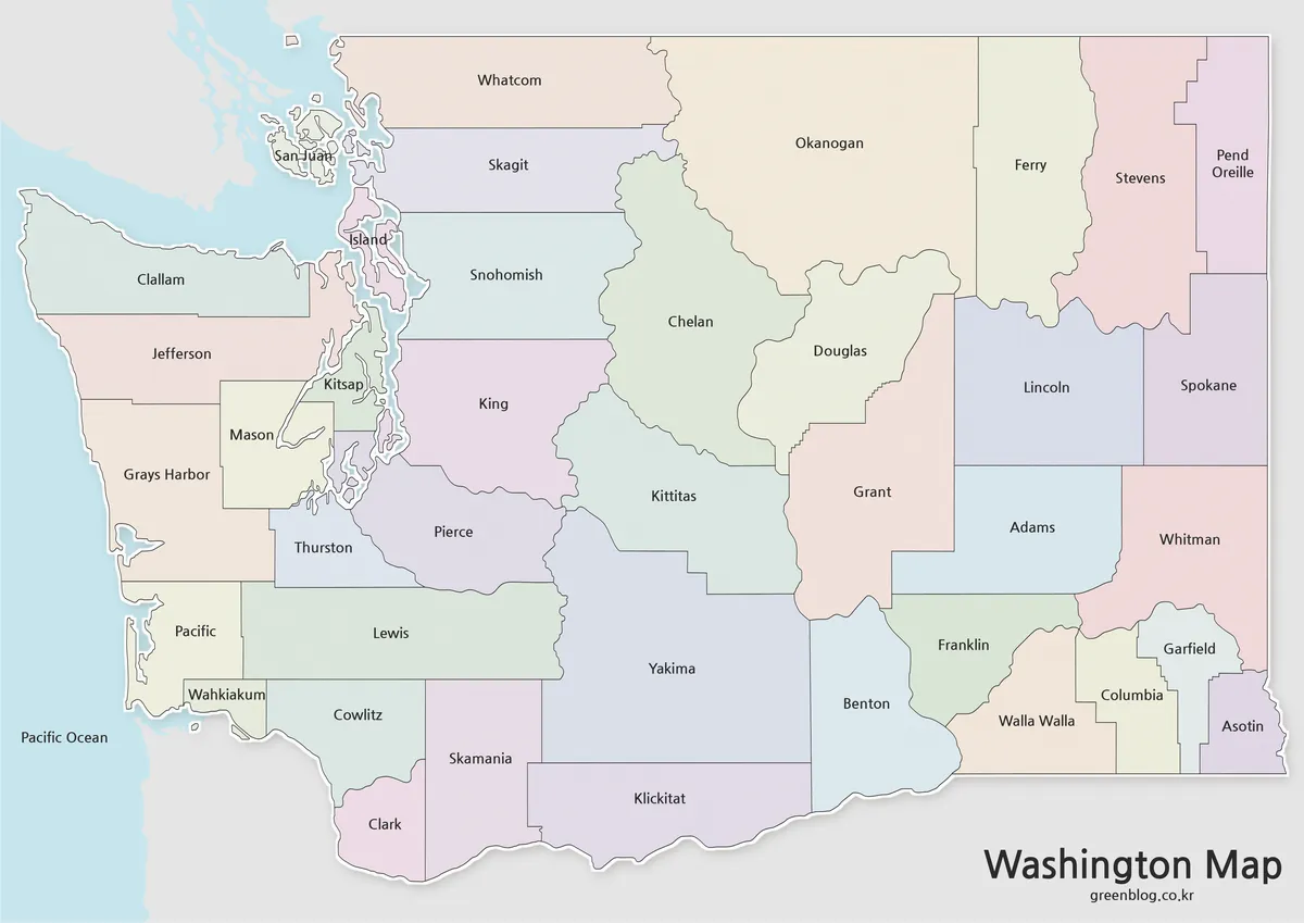
- Washington State Map Download – Color, Blank, and Printable Map Pack
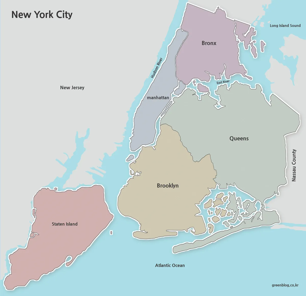
- Printable New York City Map Collection – Color, Black and White & Outline Maps
- Jamaica Map Download Pack for Printing, Education and Design Projects