Scotts Bluff County occupies the North Platte River valley in Nebraska’s Panhandle, with Scottsbluff and Gering forming the main urban center and Mitchell, Morrill, and Minatare extending along the valley in both directions. This Scotts Bluff County Map page combines towns and highways, the North Platte River and its tributaries, lakes and canals, and an elevation view that contrasts the low river corridor with the bluff country and higher ground to the south and southwest. The WebP previews are intended for quick viewing, and the same four maps are available below as high-resolution JPG files in one ZIP archive. High-resolution map files are available for download in the section below.
Scottsbluff and Gering are the easiest anchors for understanding the county. Gering lies immediately south of Scottsbluff, with Terrytown between them, while Mitchell and Morrill follow the valley westward and Minatare sits farther east. The North Platte River runs through the same broad corridor, and the dramatic Scotts Bluff landform rises just west of Gering. The county’s official history identifies Gering as the county seat and traces the county’s creation to the 1888 division of a much larger Cheyenne County.
Table of Contents
Scottsbluff and Gering at the center of the North Platte Valley
The general county map is busiest around Scottsbluff, Terrytown, and Gering. U.S. 26 approaches from the west through the Mitchell area, crosses the main urban corridor, and continues east toward Minatare. Nebraska 71 reaches Gering from the south, while Nebraska 92 helps organize the far western side near Lyman. Routes 29, 20, and 21 add local north-south connections around Mitchell and Scottsbluff, making the central valley the clearest transportation focus on the map.
Scottsbluff carries the largest city label, while Gering sits immediately to the south. Terrytown fills the narrow space between them, so the three places appear almost continuous at county scale even though they are separate municipalities. Mitchell and Morrill are spaced along the western river corridor, and Minatare lies on the eastern side. Melbeta and McGrew provide smaller reference points along the southeastern route network.
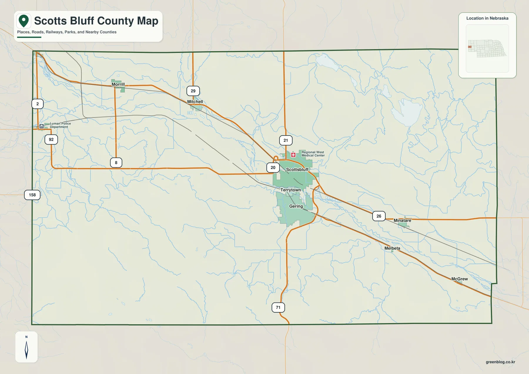
The western side becomes more rural around Morrill and Lyman, with Nebraska 92 and local roads crossing the open valley and uplands. Moving toward Scottsbluff and Gering, the road pattern becomes much denser. East of the urban center, Minatare and Melbeta are separated by broader agricultural and open areas. The contrast makes it easy to see how strongly settlement is concentrated in the central North Platte Valley.
This map is a regional reference rather than a live navigation product. Construction, closures, and seasonal road conditions may change, so actual travel should be planned with current transportation information. Its strength is geographic orientation: it quickly shows how Scottsbluff relates to Mitchell and Morrill, where Gering sits relative to the river and Nebraska 71, and how Minatare fits into the eastern side of the county.
Six major communities spread along one long valley corridor
The ranked city map simplifies the county to Scottsbluff, Gering, Mitchell, Morrill, Terrytown, and Minatare. Scottsbluff and Gering dominate the center, with Terrytown close beside them. Mitchell and Morrill extend west along the valley, while Minatare stands alone to the east. The result is a distinctly linear distribution shaped by the North Platte River corridor rather than an even scattering of towns across the county.
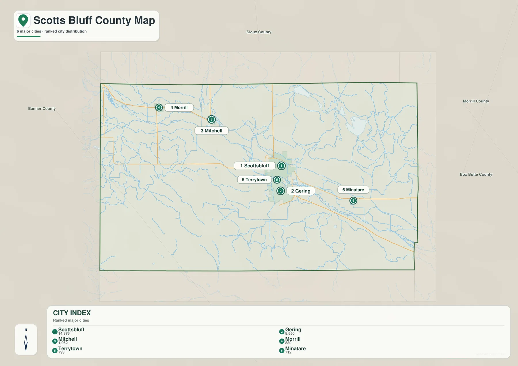
The ranking panel places Scottsbluff first and Gering second, followed by Mitchell, Morrill, Terrytown, and Minatare. Current population totals should be checked against the latest Census or municipal estimates when exact figures matter. For map reading, the more useful point is the difference in spacing: Scottsbluff, Gering, and Terrytown form a compact central cluster, while Mitchell, Morrill, and Minatare are separated by larger stretches of valley land.
The official county history adds an administrative detail that is not obvious from city size alone. Scotts Bluff County was created in 1888, and Gering became the county seat even though Scottsbluff later grew into the larger city. Seeing the two places side by side on the map helps explain why visitors may experience them as one urban area while county government remains centered in Gering.
North Platte River, canals, tributaries, and the Minatare lakes
The North Platte River is the dominant water feature. It enters the county from the northwest, crosses the central valley near the Scottsbluff–Gering area, and exits toward the southeast. Towns, highways, rail lines, and irrigated valley land broadly follow the same corridor. This relationship between water and settlement is one of the clearest county-specific patterns visible across the map set.
Owl Creek and Kiowa Creek descend from higher ground in the southwest, while Winters Creek, Horse Creek, and Nine Mile Creek appear in the northeast. The Tri State Canal runs along the northern side of the valley, reminding the reader that managed water conveyance is part of the landscape in addition to natural streams. The map does not show current canal operations or water allocations, so those questions require up-to-date information from the appropriate water-management agencies.
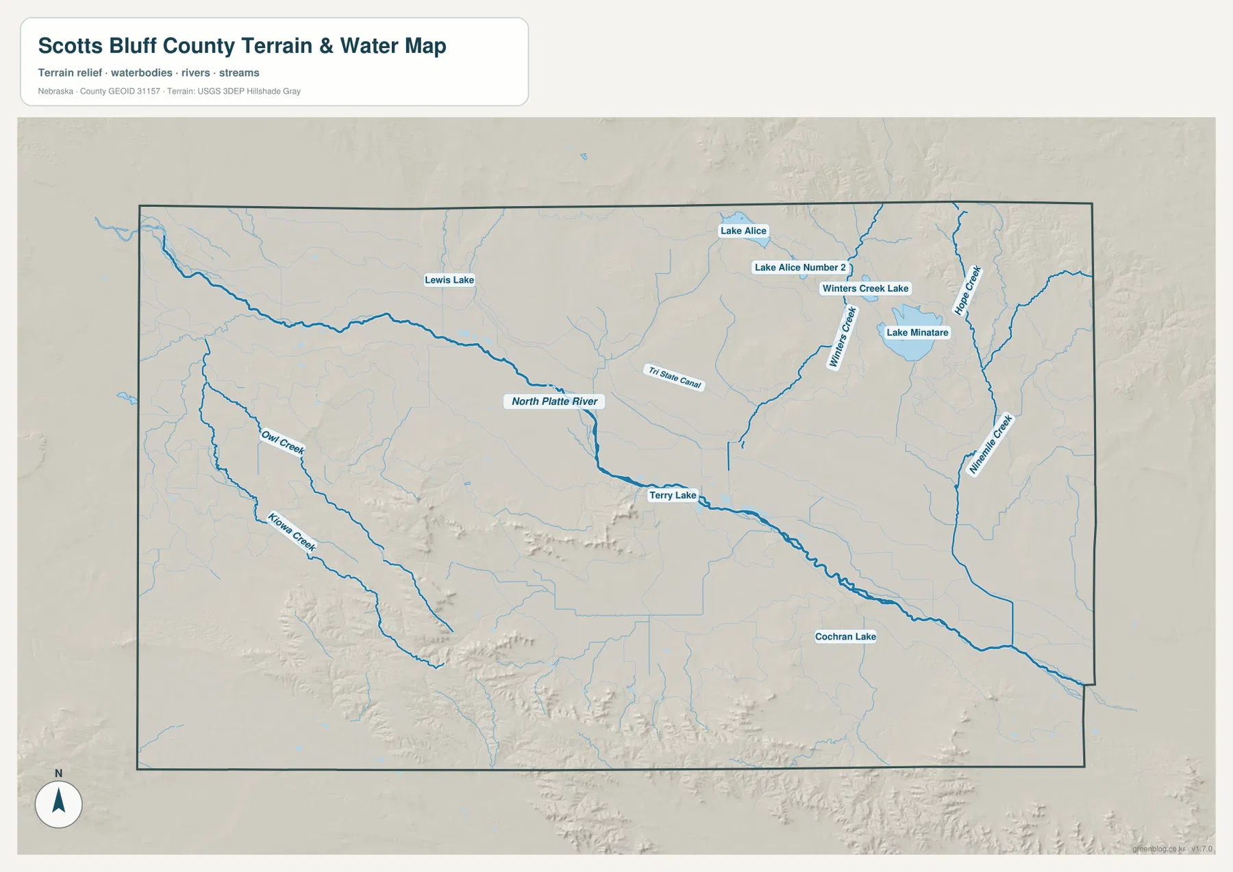
Lake Minatare is the most prominent named lake in the northeast, with Lake Alice, Lake Alice Number 2, and Winters Creek Lake nearby. Terry Lake appears near the central river corridor, Cochran Lake lies farther southeast, and Lewis Lake is labeled in the west. These labels are useful for orientation, but the map does not provide current water level, water-quality, access, fishing, or boating status.
Blue line thickness and color should not be treated as measurements of discharge, depth, or flood danger. Floodplain determinations, property restrictions, and stream-access decisions require current official sources from FEMA, USGS, and local water agencies. For general geography, the map is useful because it places the river, tributaries, canals, and lakes into one county-wide view.
From the low North Platte Valley to the bluffs and high ground south of Gering
The elevation map shows one of the strongest terrain contrasts in western Nebraska. Green follows the low North Platte River corridor, while yellow, orange, and brown spread across the south and southwest where bluffs and higher uplands rise sharply above the valley. The displayed surface ranges from roughly 1,146 to 1,507 meters, with a mean near 1,262 meters. The broad river plain and the steep bluff country are immediately distinguishable.
Scotts Bluff National Monument lies just west of Gering. The National Park Service describes the landmark as an immense sandstone and clay bluff rising about 800 feet above the North Platte River. It served as a major landmark along the Oregon, California, Mormon Pioneer, and Pony Express routes. On the county elevation image, the bluff country appears as a dramatic rise directly beside the lower green valley floor.
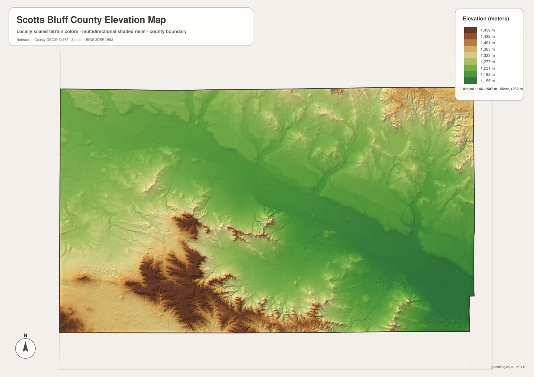
The northeast also contains rolling higher terrain, but the sharpest relief is concentrated south and southwest of the main urban valley. Owl Creek and Kiowa Creek occupy lower channels cut through that country, while shaded slopes near the bluff formations reveal abrupt local changes in height. This makes the county a good example of how a broad river valley can sit immediately beside steep erosional landforms.
The elevation image is intended for county-scale comparison rather than parcel surveying or engineering. Exact site elevations, road grades, construction benchmarks, and design values require USGS source elevation data, professional surveying, or another appropriate technical source. Here the image is best used to compare the North Platte Valley, the Scotts Bluff area, and the higher southern uplands.
Scotts Bluff National Monument and the origin of the county name
Scotts Bluff County takes its name from the landmark beside the North Platte River. The county’s official history connects the name with fur trapper Hiram Scott, who died in the area in 1828; the bluff later gave its name to both the county and the City of Scottsbluff. The relationship between the natural landmark and modern place names is especially clear here because the bluff rises immediately beside the county’s largest urban area.
The National Park Service places Scotts Bluff National Monument about three miles west of Gering and identifies it as an important landmark on the Oregon, California, Mormon Pioneer, and Pony Express trails. Mitchell Pass provided a route through the bluff country, allowing travelers to stay closer to the North Platte River. The county maps on this page do not replace the monument’s detailed visitor maps, but they provide useful regional context for where the site sits relative to Gering, Scottsbluff, and the wider river valley.
When Scotts Bluff County was separated from Cheyenne County in 1888, Gering became the county seat. Scottsbluff later became the larger city, and today the two communities occupy the same central valley only a short distance apart. That combination of historic landmark, river corridor, county government, and modern urban growth gives Scotts Bluff County a geographic identity that is unusually easy to recognize on a map.
Choosing a map for printing, teaching, or regional comparison
Use the general county map when you need cities, roads, the boundary, and nearby places in one view. Finding Scottsbluff and Gering first, then following the valley west to Mitchell and Morrill and east to Minatare, provides a simple framework for the county. The ranked city map is cleaner when the goal is to compare settlement size and spacing without the full road network.
The water map is best for tracing the North Platte River, tributaries, canals, and named lakes. The elevation image answers a different question by showing how the low valley relates to the bluff country and higher southern terrain. In a classroom, students can identify the major towns, trace the river corridor, and then compare the same places on the elevation image to see why the valley and bluffs look so different.
High-resolution JPG files are better suited to printing and close inspection when smaller creek names and route numbers matter. These maps remain regional references rather than legal or safety documents. County boundaries can be checked against Census TIGER/Line data, waterways against USGS National Hydrography, and elevation against the USGS 3D Elevation Program.
Frequently Asked Questions
Which map is easiest for comparing Scottsbluff and Gering?
The ranked city map is the simplest choice because it emphasizes the six major communities without most road detail. Scottsbluff and Gering sit close together in the center, with Terrytown between them. Use the general county map when highways and the positions of Mitchell, Morrill, and Minatare also matter.
Where can I see the North Platte River and Lake Minatare?
The water map shows both most clearly. The North Platte River crosses the county from northwest through the central valley toward the southeast, while Lake Minatare lies in the northeast. Winters Creek, Horse Creek, Owl Creek, canals, and several smaller lakes are labeled as well.
Can the elevation map be used for surveying or construction design?
No. It is intended to compare the low North Platte Valley with the bluff country and higher southern terrain at county scale. Exact site elevations, road grades, and engineering benchmarks require appropriate USGS source data or professional surveying.
Map File Information
Download the four high-resolution JPG maps shown on this page for Scotts Bluff County in one ZIP archive.
- Included Files: Use only the versions confirmed in the article and supplied images
- File Type: Use the confirmed download contents
- Intended Use: Printing, education, presentations, and map-based projects
Related Maps
Sources and references
County creation, the Gering county seat, and the origin of the Scotts Bluff name come from the official county history page. Landmark and historic-trail background comes from the National Park Service, while the federal sources below provide authoritative references for boundaries, hydrography, and elevation.
- Scotts Bluff County – County History
- National Park Service – Scotts Bluff National Monument
- U.S. Census Bureau – TIGER/Line Shapefiles
- USGS – National Hydrography
- USGS – 3D Elevation Program
Green Map creates custom-edited map images using open geographic data sources such as geoBoundaries, Natural Earth, OpenStreetMap, and government open data. These maps are edited visual materials, not raw data files, and are provided for education, documents, presentations, and graphic reference.