Rock County occupies Minnesota’s far southwestern corner, where the state meets South Dakota to the west and Iowa to the south. Luverne is the county’s main urban center, Interstate 90 crosses the middle-southern part of the county, and U.S. 75 runs north-south through Luverne toward Hardwick. The Rock River forms the most prominent natural corridor on the eastern side, while broad high ground rises to the north and northwest. The maps on this page let you compare roads, towns, waterways, and relief, and the original high-resolution JPG files are available together in the download box below.
The county is compact enough that the four map views reinforce one another especially well. On the general map, Luverne provides a useful anchor for locating Beaver Creek, Magnolia, Hardwick, Hills, Steen, Kenneth, and Jasper. The water map replaces most road detail with a dense network of creeks feeding the Rock River and other local channels. The elevation view then explains why those streams occupy distinct low corridors: higher terrain dominates much of the northern half, while the Rock River valley appears as a long lower band. Blue Mounds State Park north of Luverne gives that topographic contrast a well-known local reference point.
Table of Contents
Luverne at the meeting of I-90 and U.S. 75
The general county map is the quickest way to understand how Rock County is organized. Interstate 90 enters from the west near Beaver Creek, passes Luverne, and continues east toward Magnolia and neighboring Nobles County. U.S. 75 crosses that route at Luverne and continues north toward Hardwick before leaving the county. Those two highways create a clear cross-shaped reference near the county’s most prominent city, making Luverne easy to find even before the smaller roads and place labels are considered.
Smaller communities occupy very different parts of the county. Hills and Steen are in the south and southwest, close to the Iowa side of the map, while Jasper sits near the northwestern corner. Kenneth lies near the eastern boundary and Magnolia is farther south along the I-90 corridor. The western edge also shows routes 23 and 5, and route 270 links the southern interior toward the U.S. 75 corridor. Rather than forming a single continuous chain, the towns are distributed around Luverne in several directions and are tied together by a mixture of state, U.S., interstate, and local roads.
Rock County’s border position adds context that is easy to miss on a town-only map. The county sits at Minnesota’s southwest corner, with Pipestone County to the north and Nobles County to the east, while the state lines are immediately west and south. That means a place can be geographically close to communities in South Dakota or Iowa even when it is still within Rock County. For regional orientation, it is useful to think of Luverne not only as a Minnesota county center but also as a city near two state borders.
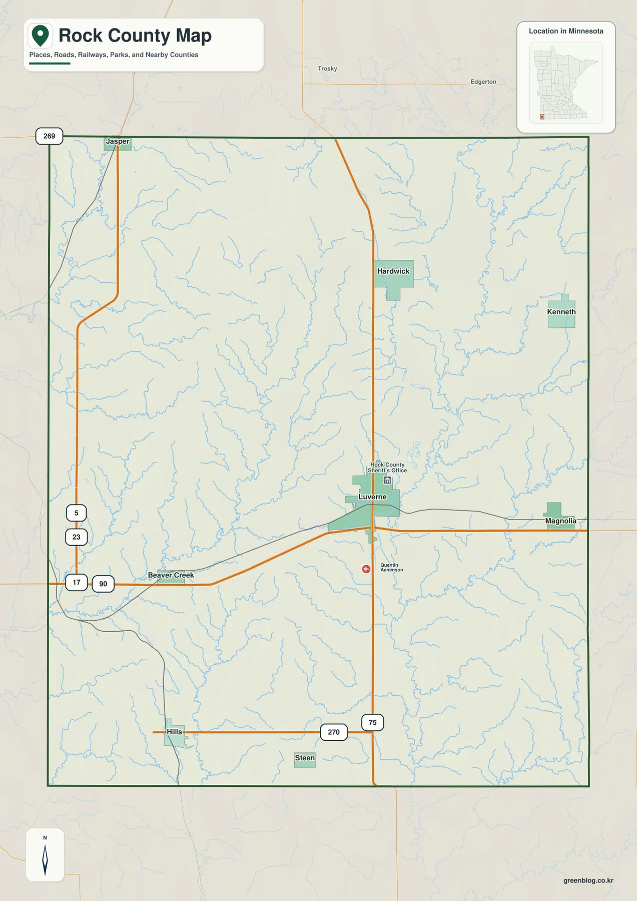
This map is best treated as a geographic reference rather than a live navigation product. It is useful for explaining why Beaver Creek and Magnolia line up along the interstate, how Hardwick relates to Luverne on the north-south corridor, or where Hills and Steen sit relative to the southern edge. Current construction, closures, road restrictions, and turn-by-turn directions can change and should be checked with current transportation sources. For a printed county overview, however, the combination of town names, numbered roads, streams, and the border makes this the most complete single image in the set.
Six ranked communities show a dispersed settlement pattern
The city map simplifies the background and ranks six major communities. Its index lists Luverne at 4,925, Jasper at 818, Hills at 748, Beaver Creek at 293, Hardwick at 235, and Magnolia at 215. Those are the values printed on the supplied map and are useful for understanding the ranking shown here. They should not automatically be treated as the latest population estimates; readers who need current demographic figures should use the latest U.S. Census Bureau data.
What matters most in this view is the spacing between the communities. Luverne stands well apart as the largest center and is located slightly east of the county’s middle. Jasper is far to the northwest, Hills is in the southwest, Beaver Creek sits west of Luverne along the interstate corridor, Hardwick is north of Luverne, and Magnolia is close to the eastern side. The pattern is therefore more dispersed than a simple main-street sequence. A resident or visitor moving among these places often travels back toward one of the principal roads rather than following a single line of towns.
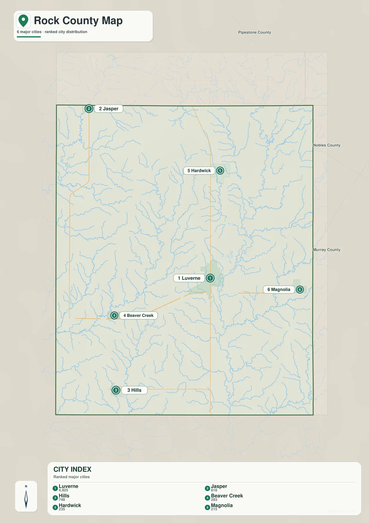
The city map also makes the county edges easier to interpret. Jasper is nearest the Pipestone County side, Magnolia faces the Nobles County side, and Hills is much closer to the Iowa border than to the northern county line. Beaver Creek is the western interstate community and therefore sits closest to the South Dakota direction. These relationships are practical when a county name alone is too broad to describe location. Saying that a place is “in Rock County” does not tell a reader whether it is near Luverne, a state line, or one of the outer towns.
The general map and city map serve different purposes here. Kenneth and Steen, for example, appear on the general view but are not among the six ranked communities on the city version. The general map also includes transportation and reference labels around Luverne. Use the ranked map when the goal is a clean comparison of major communities, and return to the general map when a project needs more place names or road context. The distinction is important because a simplified city map should not be mistaken for a complete list of every incorporated place.
Rock River is the main water corridor in a creek-rich county
Unlike many Minnesota county maps that are visually dominated by lakes, the supplied Rock County water map is dominated by streams. The Rock River is the strongest line, running through the eastern part of the county from north to south. Numerous small tributaries join it from both sides, creating a branching pattern that stands out clearly against the shaded terrain. Luverne lies immediately west of this river corridor, so the water network is closely tied to the county’s main city rather than being confined to a remote corner.
Farther west, Beaver Creek and Little Beaver Creek form another prominent system. Split Rock Creek enters the northwestern side, while Mound Creek descends through the north-central and eastern interior toward the Rock River. Elk Creek is labeled farther east, and additional smaller tributaries fill the spaces between the named channels. The result is a map with many narrow valleys but no large lake district. That difference is useful when comparing Rock County with lake-rich parts of central or northern Minnesota.
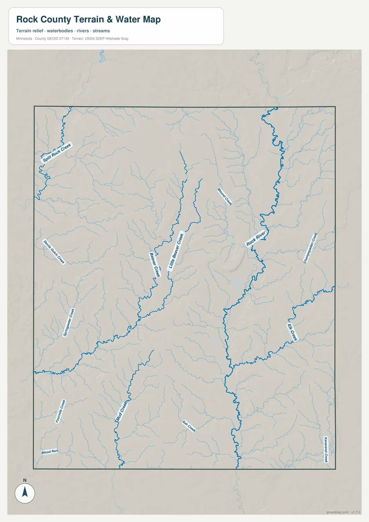
The Blue Mounds area helps connect the stream map with the landscape people see on the ground. Minnesota DNR describes Blue Mounds State Park north of Luverne as a prairie and Sioux quartzite landscape with cliffs, broad views, and a bison range. Eagle Rock provides a view well above the city and the Rock River Valley. On the maps, this higher ground sits beside lower drainage corridors, so the park is a useful real-world example of why a creek or river can be only a short distance from markedly higher terrain.
The water map should not be used as a flood-hazard, water-quality, parcel, or access map. It shows the locations and relationships of rivers and creeks in a generalized county reference. Flood zones require dedicated FEMA or state data, and land access depends on current roads, property boundaries, and local rules. Its strongest use is explanatory: it shows that Rock County’s landscape is cut by many small drainage lines and that the Rock River provides the clearest north-south valley on the eastern side.
High northern ground drops toward the Rock River valley
The elevation map provides the most dramatic visual contrast in the set. Its legend gives an actual elevation range of about 415 to 546 meters, with a mean near 469 meters. Brown and tan colors occupy much of the north and northwest, including a broad elevated surface broken by rounded rises and ridges. Green colors mark lower terrain, with the longest continuous low band following the Rock River from the north toward the southern county line.
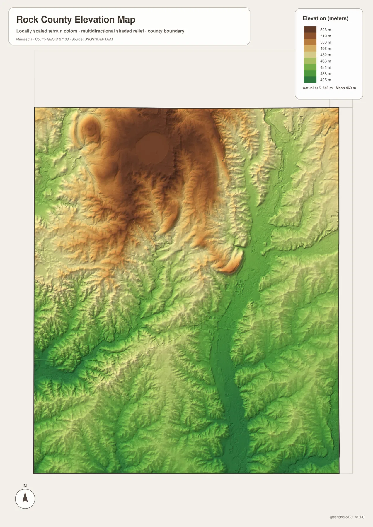
Blue Mounds State Park gives the high terrain a specific local identity. The Minnesota DNR notes the park’s Sioux quartzite cliffs, prairie, and elevated viewpoints north of Luverne. The map’s brown upland and the adjacent green river valley explain why those viewpoints feel pronounced even though the county is part of a broad prairie region. Rather than being uniformly flat, Rock County contains an elevated surface that is cut by river and creek valleys, producing short but visible changes in relief.
The smaller drainage lines also leave their mark on the elevation surface. Beaver Creek and Little Beaver Creek occupy lower grooves west of the Rock River, while several tributaries carve narrow channels into the higher northwestern ground. The pattern does not simply slope from one side of the county to the other. Local valleys branch in different directions, so comparing the elevation map with the water map is more informative than relying on a single “high side” and “low side” description.
This elevation layer is generalized for countywide understanding and is not survey-grade data. It is appropriate for comparing high and low areas, illustrating the setting of Blue Mounds, or explaining why the Rock River occupies a distinct valley. It is not appropriate for engineering design, drainage construction, property surveying, or determining the exact elevation of a building site. For precision work, consult the USGS 3D Elevation Program or a qualified survey source.
Using the four maps together for a clearer county picture
Start with the general county map when the question involves more than one type of feature. It is the best single view for finding Luverne, following I-90 and U.S. 75, locating Hills or Jasper, and seeing where streams cross the road network. Switch to the city map when the main point is settlement, because it removes much of the surrounding detail and makes the six ranked communities easy to compare. The simplified view is especially useful in a presentation where too many road labels would distract from the location of the towns.
Choose the water map for questions about the Rock River, Beaver Creek, Split Rock Creek, or the smaller tributaries. Pair it with the elevation view when explaining Blue Mounds or the shape of the Rock River Valley. The same valley that appears as a strong river line on one image becomes a green low corridor on the other, while the high northern surface changes to tan and brown. That pairing provides a simple way to show how waterways and relief are connected without requiring readers to interpret technical contour lines.
The downloadable originals are preferable to the embedded WebP previews when a project needs printing or enlargement. The archive contains four high-resolution JPG files: the general county map, ranked city map, terrain-and-water map, and elevation map. Each original is 3638×2572 pixels, giving more room to resize the image while keeping place labels, roads, and river lines legible. These maps are intended for geographic explanation and personal or educational reference, not for legal boundary determination, parcel research, or professional engineering work.
Frequently Asked Questions
What is the easiest way to locate Luverne on the county map?
Look for the intersection of Interstate 90 and U.S. 75. Luverne sits at that major east-west and north-south meeting point, with Beaver Creek to the west along I-90, Magnolia to the east, and Hardwick north along the U.S. 75 corridor. Using the highways as anchors is faster than searching the entire county for the city label.
Which river is most prominent on the Rock County water map?
The Rock River is the dominant north-south water corridor on the eastern side of the county. Beaver Creek and Little Beaver Creek are prominent farther west, and Split Rock Creek appears in the northwest. The map is useful for comparing their locations and drainage relationships, but it is not a flood-hazard or property-access map.
How much elevation change is shown across Rock County?
The elevation legend reports an actual range of roughly 415 to 546 meters, with a mean near 469 meters. The highest broad areas are in the north and northwest, while the Rock River valley forms a lower green corridor. Blue Mounds State Park north of Luverne is a useful local example of the elevated prairie and Sioux quartzite terrain visible in that part of the map.
Map File Information
The ZIP contains the original high-resolution JPG versions of the Rock County general, city, water, and elevation maps shown on this page.
- Included Files: Use only the versions confirmed in the article and supplied images
- File Type: Use the confirmed download contents
- Intended Use: Printing, education, presentations, and map-based projects
Related Maps
Sources and references
- U.S. Census Bureau QuickFacts: Rock County, Minnesota — current county population and geography reference
- Minnesota DNR Blue Mounds State Park — Sioux quartzite cliffs, prairie, bison range, and terrain north of Luverne
- U.S. Census Bureau TIGER/Line Shapefiles — authoritative boundary, road, and place reference
- USGS National Hydrography — authoritative river and stream reference
- USGS 3D Elevation Program — elevation and terrain reference
Green Map creates custom-edited map images using open geographic data sources such as geoBoundaries, Natural Earth, OpenStreetMap, and government open data. These maps are edited visual materials, not raw data files, and are provided for education, documents, presentations, and graphic reference.