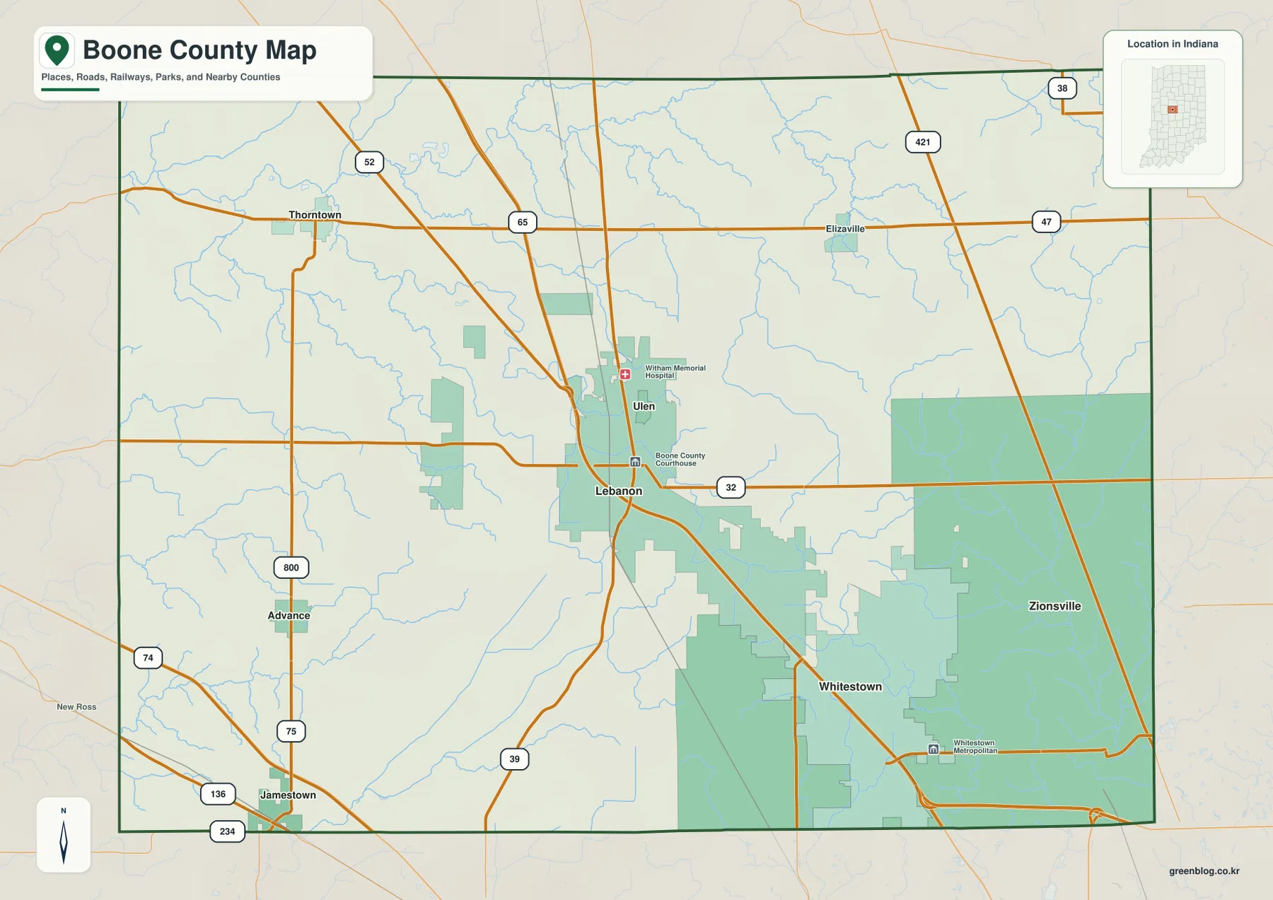
You can download a ZIP of high-resolution Boone County JPG maps directly from this page, with separate views for county roads and boundaries, community locations, waterways, and elevation. Boone County sits in central Indiana, where Lebanon works as the main point of orientation while Zionsville and Whitestown form a strong eastern and southeastern focus. Thorntown lies to the northwest, Jamestown is near the southwest corner, Advance is on the west, and Elizaville provides a smaller reference in the northeast. The on-page WebP maps are convenient for quick viewing, while the downloadable JPG files are better for printing, presentations, and close inspection of labels.
Several numbered roads make Lebanon an effective starting point. State Road 32 crosses the county through Lebanon, U.S. 421 runs through the eastern side, State Road 47 crosses the north, and U.S. 52 enters the northwestern part of the county. The general map also labels the Boone County Courthouse and Ulen just north of Lebanon. Boone County’s official resource guide describes the Big 4 Trail as connecting Thorntown, Lebanon, Whitestown, and Zionsville; the trail line is not drawn as a separate route on these maps, but that local description helps explain the northwest-to-southeast relationship among those communities.
The natural-feature maps add a different layer to the county. Sugar Creek winds across the northwest, while Eagle Creek is a strong eastern reference, and smaller streams such as Prairie Creek, Deer Creek, and Browns Wonder Creek occupy the area between them. The elevation graphic reports an actual county range of about 235 to 307 meters, with a mean near 280 meters. Lower terrain is most obvious in the northwest, whereas broader higher ground spreads across much of the center and east. Reading the water and elevation views together makes those contrasts easier to recognize.
Table of Contents
Lebanon and the roads that organize the county map
Lebanon sits close enough to the middle of Boone County to serve as a practical map anchor. Ulen is immediately north of it, Whitestown appears southeast, and Zionsville is farther east near the county edge. Thorntown is well to the northwest, Jamestown is in the southwest, Advance is on the western side, and Elizaville appears in the northeast. That spread matters because a reader who starts at Lebanon can move outward in several directions instead of trying to memorize every place name at once.
State Road 32 gives the clearest east-west reference through Lebanon. Farther north, State Road 47 crosses the county near the latitude of Thorntown and Elizaville. U.S. 421 provides a north-south reference on the eastern side, while U.S. 52 is useful for locating the northwest. State Road 75 helps with the western side, and U.S. 136 and State Road 234 are useful around Jamestown. State Road 39 extends south from the Lebanon area. Together these highways make the county easier to navigate visually because each outer community can be related to one or two major routes.
Nearby county labels provide additional orientation. Clinton County lies to the north, Hamilton County is east, and Montgomery County is west; Hendricks County and Marion County appear around the southern side on the city-distribution view. These surrounding names help explain why Zionsville and Whitestown feel closer to the Indianapolis side of Boone County than Thorntown or Jamestown. The boundary shown here is appropriate for a county overview, but it is not a substitute for parcel lines, deeds, or a legal property survey.
An eastern cluster around Zionsville and Whitestown, with wider spacing to the west
The city-distribution map removes much of the road detail and makes the settlement pattern easier to see. Zionsville occupies the eastern side, Whitestown sits to its southwest, and Lebanon remains near the center. Thorntown is separated from Lebanon toward the northwest, Jamestown is farther southwest, and Advance is between those western reference points. The eastern communities therefore read as a tighter grouping, while the western communities are separated by more open map space.
That difference is useful when Boone County is being introduced to someone who does not know the local geography. Lebanon is important as the county seat and central road reference, but the map also shows that Zionsville and Whitestown form a distinct eastern focus. On the general map, the larger green developed areas reinforce that contrast, especially around Zionsville and Whitestown. West of Lebanon, the named places are smaller and farther apart, so the county does not have one uniform settlement pattern from edge to edge.
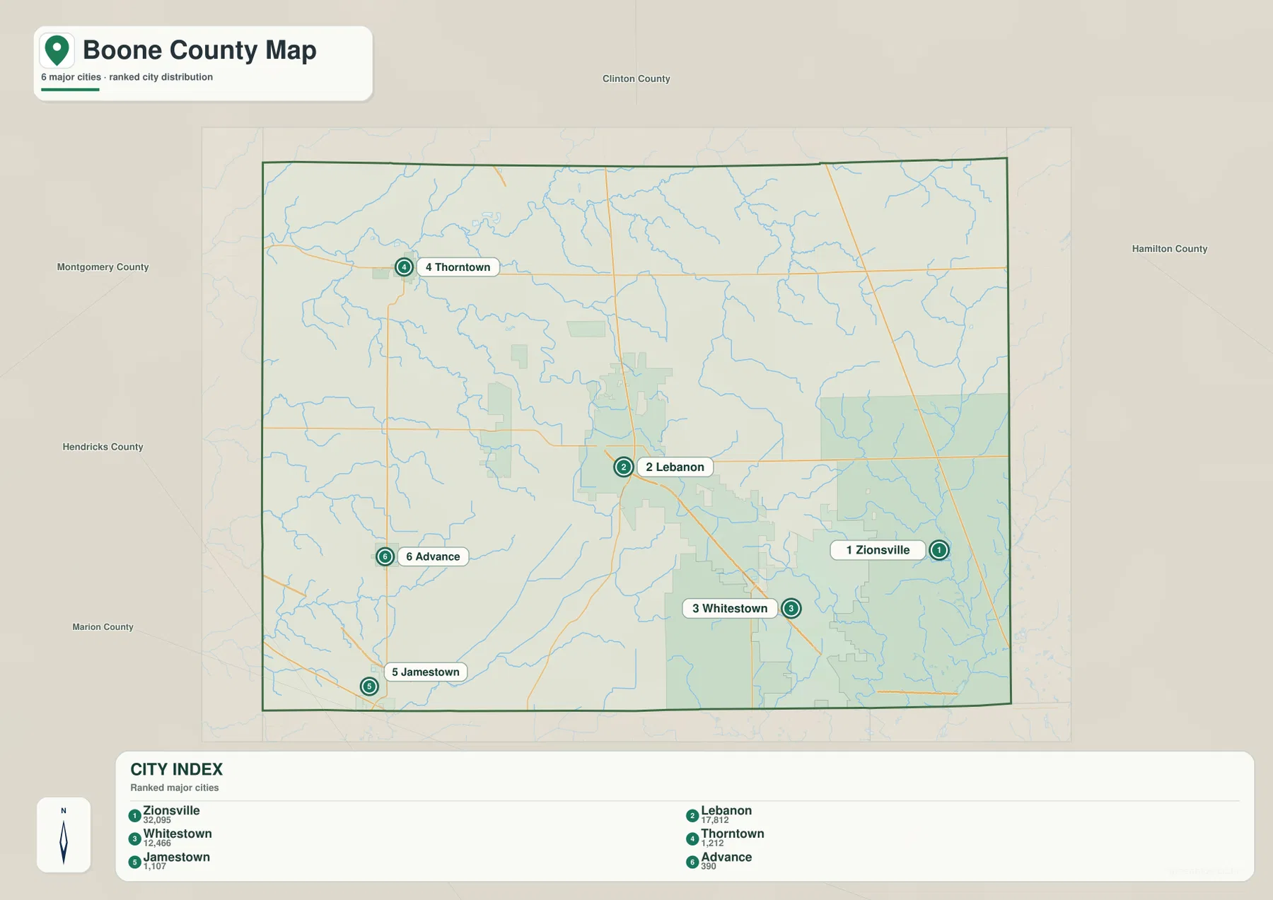
The county resource guide gives useful local context by describing the Big 4 Trail as linking Thorntown, Lebanon, Whitestown, and Zionsville. Those four places also form an easy sequence to locate on the city map from northwest through the center toward the southeast and east. The city map, however, is not a route planner and it does not provide drive times or detailed trail geometry. It is best used for relative placement before switching to an official trail map or a road-navigation service for an actual trip.
Many named creeks between Sugar Creek and Eagle Creek
The water map shows a county crossed by numerous streams rather than dominated by one large river. Sugar Creek is the most obvious feature in the northwest, where it bends across the upper part of the county. Little Sugar Creek appears farther west, while Wolf Creek and Deer Creek occupy the west-central area. Prairie Creek runs through the north-central part of the county and continues southward, creating a useful middle reference between the western and eastern drainage features.
Farther east, Browns Wonder Creek is labeled through the central-eastern area and Mounts Run appears nearby. Eagle Creek follows the eastern side and provides a strong contrast with Sugar Creek on the opposite side of the county. In the southeast, Fishback Creek runs near Holliday Lake, Russell Lake, and Eagle Lake. Big Raccoon Creek and North Fork Big Walnut Creek appear in the southwest. The result is a map where named water features can be found in nearly every section of Boone County.
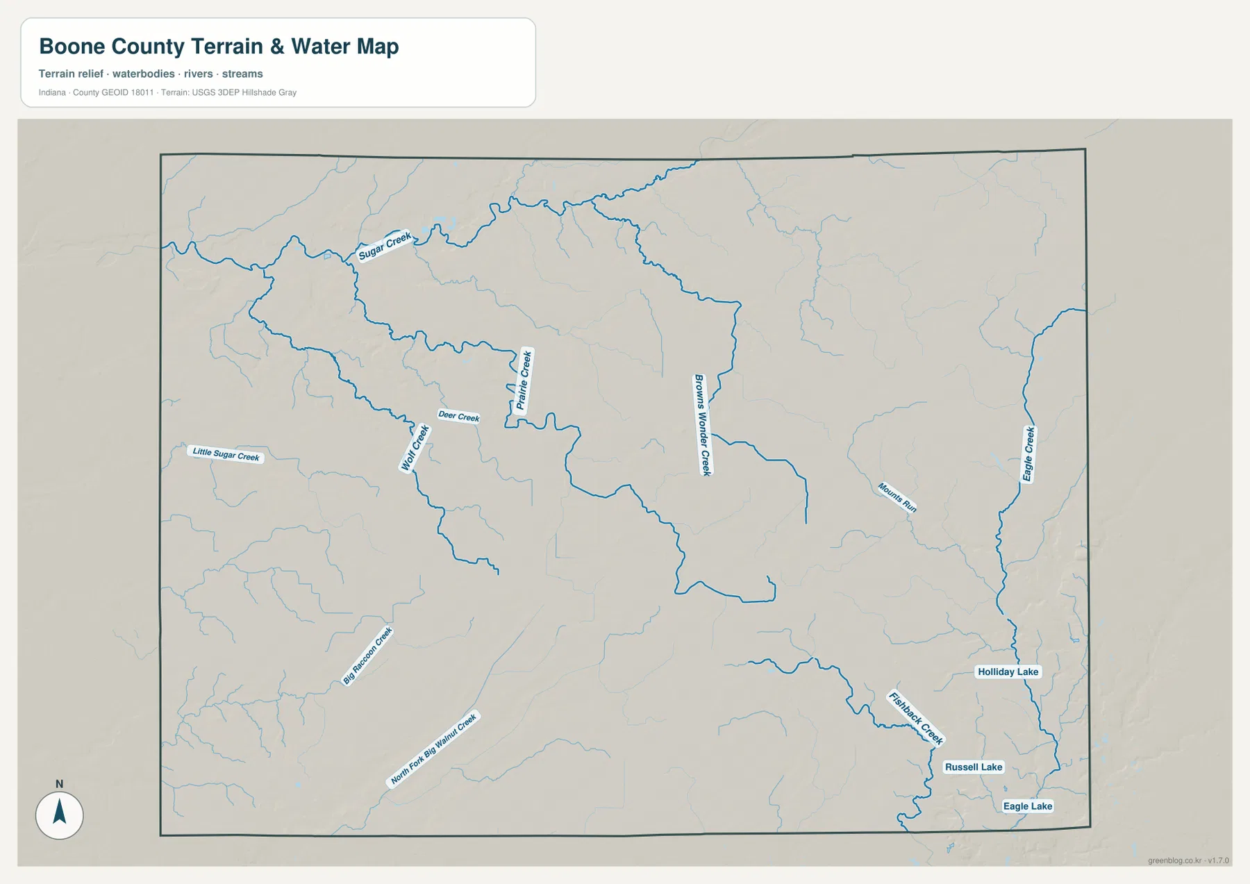
This view is meant to identify waterways and their broad position within the county. It is especially useful when a thin blue line on the general map is not enough to tell which stream is being shown. It should not be treated as a flood-hazard map, a parcel map, or a navigation product. Flood-insurance zones, regulatory floodplains, channel conditions, drainage infrastructure, and legal water boundaries require separate official sources designed for those purposes.
Why the northwest looks lower on the elevation map
The elevation graphic reports a Boone County range of roughly 235 to 307 meters and a mean close to 280 meters. Its locally scaled colors are intended to show differences within this county: greener tones are lower, while yellow and brown tones indicate higher ground. The broadest low area appears in the northwest, and much of the center and east is shown in warmer, higher colors. This does not make Boone County mountainous; it means the map can reveal gradual relief that is easy to miss on a road map.
The northwest low area overlaps the broader Sugar Creek corridor, which helps connect the water and elevation views. Across the center, colors rise into a wide zone of higher ground. Along the eastern and southeastern side, narrow green corridors cut through warmer colors where streams occupy lower ground. Looking first at Eagle Creek and Fishback Creek on the water map makes those linear low areas easier to identify on the elevation map. The southwest also contains higher terrain, but the central and eastern high area is the stronger countywide pattern.
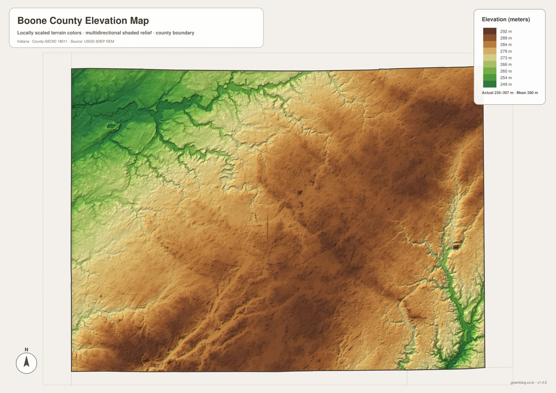
The color ramp is local to this map, so the same color on a different county map should not be assumed to represent the same elevation. The shaded surface is also a county-scale representation rather than a survey product. It is useful for recognizing broad high and low areas and for comparing stream valleys with surrounding ground, but it should not be used as an engineering elevation for a building site, drainage plan, or construction project. Site-specific decisions need survey-grade or purpose-built official elevation data.
Choosing the right Boone County view and downloading the JPG files
For basic orientation, begin with the general map because it combines the county outline, Lebanon, outer communities, numbered roads, and background water features. If the road network is distracting and the goal is simply to explain where Zionsville, Whitestown, Thorntown, Jamestown, and Advance sit relative to Lebanon, the city-distribution map is cleaner. These two views work well together for classroom handouts, local-history pages, or presentations because one supplies the road framework and the other simplifies the settlement pattern.
For natural features, the water and elevation maps answer different but related questions. Sugar Creek and Eagle Creek are easy first references on the water view, while Prairie Creek and Browns Wonder Creek fill in the middle of the county. The elevation map then shows that the Sugar Creek side of the northwest is generally lower and that higher ground spreads through much of the center and east. When both water and relief matter, using the two maps side by side is clearer than trying to infer terrain from stream names alone.
The WebP images on the page are reduced for quick viewing. The downloadable package contains separate high-resolution JPG versions of the general county map, city-distribution map, terrain-and-water map, and elevation map. Each JPG is 3638 × 2572 pixels, giving more room for print layouts or zoomed inspection of labels and linework. Because the files remain separate, a reader can use only the road map, only the water map, or only the elevation view when a simpler presentation is preferable.
Where a county reference map stops and specialized data begins
These maps are designed for countywide reference, not for every possible mapping task. The general map emphasizes roads, communities, and the county outline. The city view simplifies the county to highlight selected communities, the water view labels streams and lakes, and the elevation view compares broad differences in height. A feature that is prominent on one map may be reduced or absent on another because each image has a different purpose. Choosing the map according to the question is more reliable than assuming every layer should contain the same detail.
Parcel ownership, legal property boundaries, flood-insurance zones, regulated waterways, exact channel conditions, and engineering-grade elevations require specialized official records. The JPG files here are better suited to geographic orientation, educational use, presentations, printable overviews, and general local reference. Readers who need the underlying public data can use the sources below for Boone County information, Census geographic files, U.S. Geological Survey hydrography, and USGS elevation resources.
Frequently Asked Questions
Where is Lebanon in relation to Zionsville and Whitestown?
Lebanon is near the center of Boone County. Zionsville is farther east near the county edge, while Whitestown lies southeast of Lebanon and west of Zionsville. The city-distribution map gives the clearest quick comparison, and the general county map is better when you also want to see the numbered roads between the communities.
Can the water map be used to find both Sugar Creek and Eagle Creek?
Yes. Sugar Creek is labeled across the northwestern part of Boone County, and Eagle Creek is shown near the eastern edge. Prairie Creek, Deer Creek, Browns Wonder Creek, Mounts Run, Fishback Creek, and other named waterways appear between or around them. The map identifies broad locations, but it is not a floodplain or navigation map.
Does the 235–307 meter elevation range provide survey-grade heights?
No. The 235–307 meter range is the actual countywide range reported on the supplied elevation graphic, which also lists a mean near 280 meters. The colors help compare broad high and low areas within Boone County, but they do not guarantee an exact elevation for a parcel or construction site. Survey or engineering work requires more precise, purpose-specific data.
Map File Information
Download the Boone County maps as high-resolution JPG files when you need larger images for printing, presentations, or closer inspection than the WebP versions on this page.
- Included Files: general county map, city-distribution map, terrain-and-water map, and elevation map
- Printable Size: 3638 × 2572 px for each map
- File Type: four JPG images in one ZIP archive
Related Maps
Sources and References
- Boone County, Indiana official website — county administration and local information
- Boone County Resource Guide — local facilities and the Big 4 Trail connection
- U.S. Census Bureau TIGER/Line Shapefiles — county boundaries, roads, and place geography
- USGS National Hydrography — streams and water features
- USGS 3D Elevation Program — elevation and terrain data
Green Map creates custom-edited map images using open geographic data sources such as geoBoundaries, Natural Earth, OpenStreetMap, and government open data.
These maps are edited visual materials, not raw data files, and are provided for education, documents, presentations, and graphic reference.