Roseau County occupies a broad stretch of northwestern Minnesota immediately south of the Canadian border. Roseau, Warroad, Greenbush, Badger, Roosevelt, and Strathcona are spread across a landscape shaped by flat former lake plains, river channels, wetlands, and higher ground in the southeast. Minnesota Highway 11 gives the county an easy east–west reference line, connecting Greenbush and Badger with Roseau before continuing toward Warroad near Lake of the Woods. This page includes a general county map, a city map, a water map, and an elevation map, and the original high-resolution JPG files can be downloaded together from the map file box below.
The four views reveal differences that are easy to miss on a single road map. The western and northern parts of the county are generally low and subdued, while the southeastern corner rises more clearly on the elevation map. The Roseau River crosses the middle of the county and receives numerous tributaries and drainage channels. Farther east, the East and West Branches of the Warroad River lead toward Warroad and Lake of the Woods. Much of this terrain lies on the former floor of Glacial Lake Agassiz, but old shoreline ridges and the higher Beltrami Island area break the otherwise broad plain.
Table of Contents
Following MN 11 from Greenbush through Roseau to Warroad
The general county map is easiest to enter through Minnesota Highway 11. It crosses the county from west to east, passing Greenbush and Badger before reaching Roseau and continuing toward Warroad and Roosevelt. Because Roseau County is wide and its communities are separated by long rural distances, this route provides a simple way to understand the main settlement pattern. Roseau sits slightly north of the county’s center and functions as an important road junction, while Warroad occupies the eastern side close to the shore of Lake of the Woods.
Several north–south routes become clearer once MN 11 is established as the baseline. Minnesota Highway 89 passes through the western-central part of the county, while Highway 310 runs north from Roseau toward the international border. Near Warroad, Highway 313 also heads toward Canada. Across the western and southern farm country, many numbered county roads form a regular grid. The eastern and southeastern portions look less uniform because river channels, wet lowlands, wooded areas, and changing relief interrupt the straight road pattern.
The county outline is also worth noticing. Canada lies directly to the north, and Lake of the Woods County borders the eastern side. Marshall County is to the west, while Kittson and Beltrami County areas are nearby to the south and southwest. The eastern boundary bends around the Warroad and Roosevelt side of the county instead of forming a simple rectangle. Learning that outline makes Roseau County easier to recognize when it appears beside other northwestern Minnesota counties on a regional map.
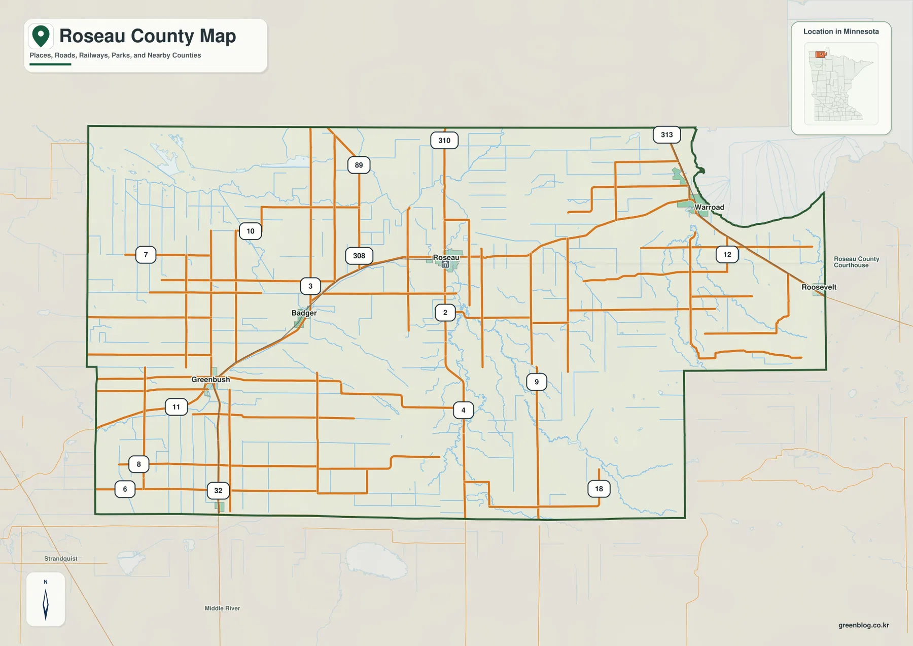
This is a geographic reference map rather than a live navigation map. It works well for explaining where Warroad sits relative to Roseau, how Badger and Greenbush line up to the west, or where roads toward the Canadian border leave the main east–west corridor. Current driving conditions, winter closures, construction, and border requirements can change, so those details should be checked with current transportation and border sources. For classroom, presentation, or regional orientation purposes, however, the map provides a useful overview before moving to the more specialized city, water, and elevation views.
A dispersed city pattern led by Roseau and Warroad
The city map removes much of the road detail and emphasizes six communities. The index printed on the supplied map lists Roseau at 2,736, Warroad at 1,959, Greenbush at 678, Badger at 391, Roosevelt at 150, and Strathcona at 34. These are the values used in the map’s ranking and should not be treated as a live population estimate. Anyone needing the latest population figures should use the current U.S. Census Bureau data. For this map, the more important information is the spacing and direction of the communities.
Roseau is the largest of the six mapped places and sits in the north-central part of the county. Warroad is well to the east, close to Lake of the Woods and the county’s northeastern side. Greenbush and Badger lie west of Roseau along the Highway 11 corridor, so their relationship is easy to follow even on a simplified city map. Roosevelt is close to the eastern boundary, while Strathcona is far to the southwest. The pattern is notably dispersed: there is no single compact cluster of towns covering the county.
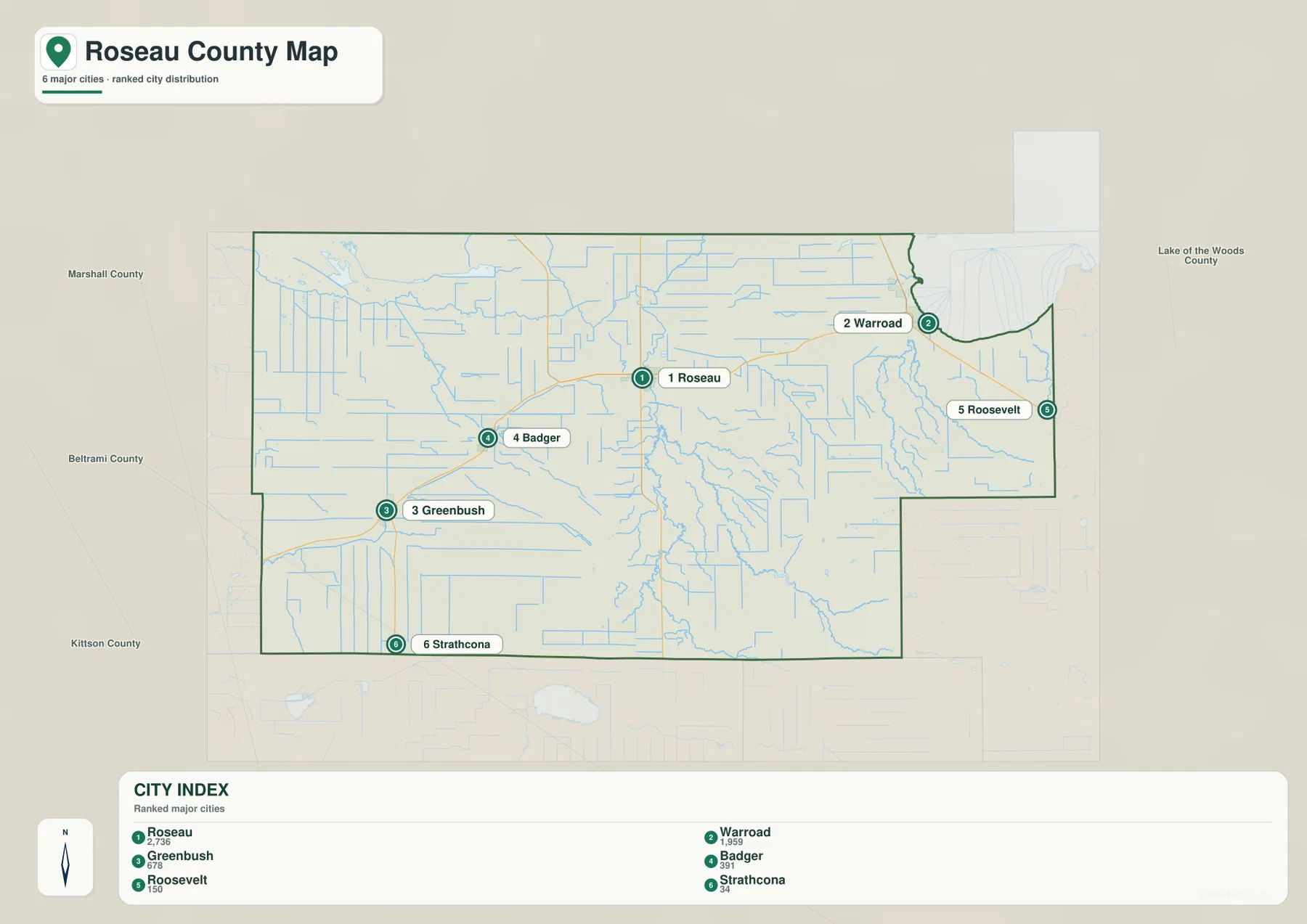
Roseau and Warroad also represent two different geographic settings. The City of Roseau describes Roseau as the county seat and a regional center for commerce, health care, and government. It stands inland along the Roseau River and the main road network. Warroad, by contrast, is positioned on Lake of the Woods and is closely tied to the lake environment. Seeing the two cities on the same map helps explain why both are important even though they occupy different parts of the county and connect to different natural features.
Greenbush and Badger provide useful reference points for the western farm country. Their surrounding roads are more regular and widely spaced than the drainage-rich areas farther east. Strathcona, near the southwestern edge, shows just how far the county’s smaller settlements extend away from Roseau. Roosevelt, near the eastern boundary, is better understood when viewed together with Warroad and the neighboring Lake of the Woods County area. The city map is therefore particularly useful when the goal is to compare community placement without the visual competition of every local road and stream.
Roseau River, Warroad River branches, and managed water areas
The Roseau River is the dominant natural watercourse on the water map. It passes through the central part of the county and is joined by the South Fork Roseau River and many smaller channels. Numerous straight drainage lines are also visible, especially across the flatter western and northern landscape. That combination reflects the character of this former glacial lake plain, where low relief and poorly drained ground have required extensive drainage in many places. The Minnesota Pollution Control Agency notes that the Roseau River watershed was once covered by Glacial Lake Agassiz and still includes extensive wetlands.
The eastern side has a different water pattern. East Branch Warroad River and West Branch Warroad River are both labeled on the map and lead toward the Warroad area. Lost River appears farther north, while Marvin Lake and Luxemburger Lake provide smaller named water bodies. Beyond Warroad is the much larger Lake of the Woods, which gives the northeastern corner of the county a very different setting from the agricultural west. The contrast between a river-and-drainage landscape inland and a major lake shore near Warroad is one of the most distinctive features of the county.
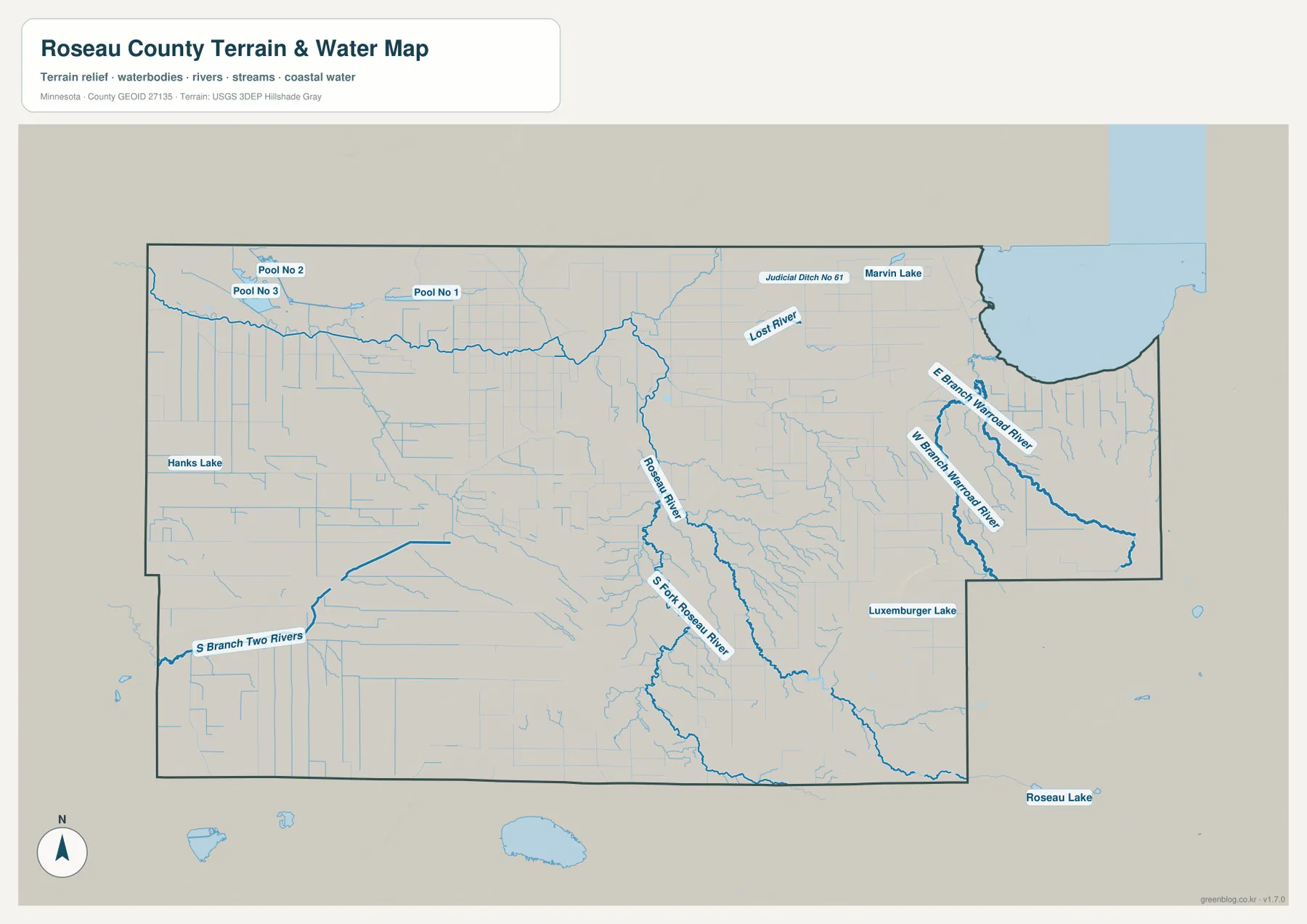
The northwestern portion of the map includes Pool No. 1, Pool No. 2, and Pool No. 3. These labels should not automatically be read as ordinary natural lakes. The Minnesota Department of Natural Resources describes the Roseau River Wildlife Management Area as a large managed wetland complex with major water-control structures, wildlife pools, and moist-soil cells used to support waterfowl habitat. That context helps explain why some of the water features and straight channels on the map look engineered rather than naturally meandering.
Other labels include Hanks Lake in the west, South Branch Two Rivers near the southwest, and Roseau Lake outside the county outline to the south. These features are useful for geographic orientation, but the water map is not a flood-hazard map, water-quality map, fishing regulation map, or property-access guide. Anyone planning activities on or near a specific water body should confirm current conditions with the DNR, USGS, watershed district, or other responsible agency. For general geographic use, the map is best for understanding how rivers, drainage channels, pools, and lakes are arranged across the county.
From the low lake plain to higher ground in the southeast
The elevation map adds an important layer to the county story. Its legend gives an actual mapped range of roughly 308 to 387 meters, with a mean near 333 meters. Broad green areas dominate the west and northwest, showing the subdued surface of the former lake plain. The Roseau River corridor also remains comparatively low. In the southeast, however, yellow, orange, and brown tones become much more prominent, marking higher ground that stands out clearly from the flatter parts of the county.
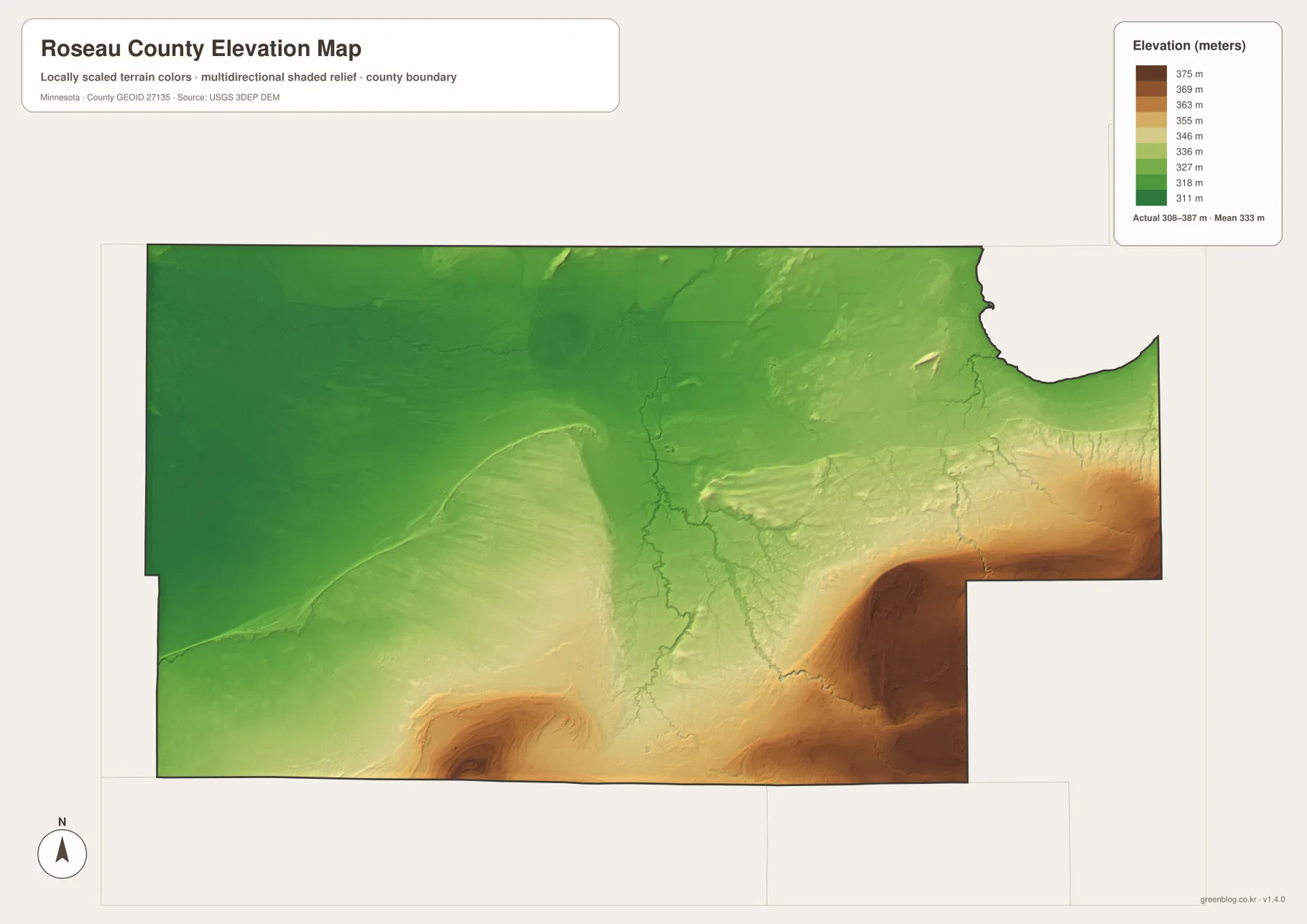
USGS descriptions of the Roseau River watershed help explain this pattern. Most of the watershed lies on the plain left by Glacial Lake Agassiz, but the otherwise level surface is interrupted by former beach ridges in the southwest and by Beltrami Island, a topographic high underlain by sand, in the southeast. The elevation map shows that southeastern high ground particularly well. It is not a mountain landscape, yet the difference is substantial enough to produce a visible change in relief and drainage compared with the broad lowlands around Roseau and farther west.
Subtle curved and elongated rises can also be seen in the western half of the county. They are much lower than the southeastern high ground, but they matter because even small changes in relief stand out on such a flat plain. A separate higher patch appears near the southern edge as well. The county therefore should not be summarized simply as “higher in the south and lower in the north.” A better reading distinguishes the large southeastern high area, the lower Roseau River corridor, the broad northwestern plain, and smaller ridges or rises elsewhere.
The shaded relief is intended for regional comparison, not survey-grade elevation work. It should not be used to determine an exact building-pad height, engineering grade, drainage design, or legal property elevation. Those tasks require the source elevation data or a professional survey. For education and general geography, however, this map makes the relationship between water and relief much easier to see. Comparing it with the water map shows why major channels occupy lower terrain and why drainage patterns become more intricate near changes in elevation.
How the Lake Agassiz landscape changes from west to east
One of the most useful ways to read Roseau County is to move across it from west to east. Around Greenbush and Badger, straight roads and drainage channels cross a broad, low agricultural landscape. Approaching Roseau, the river and its tributaries become more important reference features. Continuing east toward Warroad, the map begins to reflect the influence of Lake of the Woods and the Warroad River system. South of that corridor, the elevation map introduces a separate change as the southeastern terrain rises above the flatter lake plain.
Glacial Lake Agassiz provides the long-term setting for these differences. Minnesota DNR descriptions of the Lake Agassiz region explain that the former glacial lake left broad deposits of sand, silt, clay, and old shoreline ridges as its water levels fell. In the Roseau River watershed, USGS likewise describes a mostly low-relief lake plain broken by beach ridges and the Beltrami Island high. These landforms help explain why the county can look extremely flat in one area and noticeably more textured in another even though the total elevation range is less than 100 meters.
Warroad adds another geographic dimension because it sits on Lake of the Woods rather than entirely within the inland river plain. The City of Warroad describes the community as a Lake of the Woods city with strong connections to fishing, boating, winter recreation, and other lake-based activities. On the county map, its position at the eastern edge immediately distinguishes it from Roseau, Badger, and Greenbush. Including Warroad and the lake in a county overview prevents Roseau County from being reduced to a single image of flat inland farmland.
Choosing the right Roseau County map for a specific task
Use the general county map when roads, communities, and boundaries need to appear together. It is the best choice for explaining the MN 11 corridor, locating Roseau relative to Warroad, or showing the roads that head toward Canada. The city map is cleaner when the purpose is simply to compare the six major communities and their spacing. It removes much of the background detail and makes the long distances between Strathcona, Roseau, Warroad, and Roosevelt easier to see.
Choose the water map when the Roseau River, South Fork Roseau River, Warroad River branches, drainage channels, lakes, or managed pools are the main subject. For landform questions, the elevation map is much more direct because the higher southeast and lower western plain are immediately visible. When comparing two maps, start with a place or feature that appears clearly in both—Roseau, Warroad, or the Roseau River are good examples—then trace the same location into the second view.
For a classroom lesson or presentation, changing maps to match the question usually produces a clearer result than forcing every topic onto the general map. The city map answers “where are the communities?” The water map answers “where do the rivers and managed waters run?” The elevation map answers “where does the land rise or fall?” For trip planning, the maps are useful as background orientation, but current road, facility, border, and access conditions should be checked separately. Legal boundaries, ownership, flood regulation, and engineering work also require authoritative purpose-specific data.
The WebP images embedded in the article are reduced previews for efficient viewing. The downloadable archive contains four original JPG maps, each 3638 × 2572 pixels: the county map, city map, water map, and elevation map. The larger originals are better for printing, placing in an A3-size document, or zooming into labels and smaller features. They can be used as general reference graphics, but they should not replace legal surveys, official navigation products, or specialized hazard and engineering maps.
Frequently Asked Questions
What is the easiest way to locate Roseau and Warroad on the county map?
Find Minnesota Highway 11 and follow it east. Roseau sits in the north-central part of the county where several routes meet, while Warroad is farther east near Lake of the Woods. Greenbush and Badger are both west of Roseau on the same general corridor. Using Highway 11 as the reference line is usually faster than searching for each city independently.
Why is southeastern Roseau County higher on the elevation map?
Most of the Roseau River watershed lies on the former floor of Glacial Lake Agassiz, but USGS describes Beltrami Island in the southeast as a topographic high underlain by sand. That difference appears clearly in the supplied elevation map, where the southeast is shown in warmer, higher-elevation colors than the western and northern plain. The map legend gives an overall range of about 308 to 387 meters.
Are Pool No. 1, Pool No. 2, and Pool No. 3 ordinary natural lakes?
They are better understood in the context of the managed Roseau River Wildlife Management Area. Minnesota DNR describes the area as using large water-control structures, wildlife pools, and moist-soil cells to manage wetland habitat for waterfowl. The labeled pools on the map therefore should not be assumed to function like unmanaged natural lakes. Current access and management details should be checked with the DNR.
Map File Information
The ZIP includes the original JPG versions of the Roseau County general, city, water, and elevation maps.
- Included Files: 4 high-resolution JPG maps
Related Maps
Sources and references
- U.S. Census Bureau QuickFacts: Roseau County, Minnesota — county land area and population reference
- Roseau County Interactive Map — official county GIS reference
- City of Roseau: About Roseau — county-seat and regional context
- City of Warroad: About Us — Warroad and Lake of the Woods context
- Minnesota DNR Roseau River Wildlife Management Area — managed wetland and wildlife-pool information
- USGS Water Resources of the Roseau River Watershed — Lake Agassiz plain, beach ridges, and Beltrami Island relief
Green Map creates custom-edited map images using open geographic data sources such as geoBoundaries, Natural Earth, OpenStreetMap, and government open data. These maps are edited visual materials, not raw data files, and are provided for education, documents, presentations, and graphic reference.