Barnstable County follows the long, hooked peninsula of Cape Cod in southeastern Massachusetts. Its outline is a major part of the geography: the county begins with the broader Upper Cape near Falmouth and Sandwich, stretches east around Cape Cod Bay, then narrows and bends north along the Outer Cape. Because the land changes direction so dramatically, a road or town makes more sense when it is viewed together with the surrounding bays, sounds, and ocean rather than as a simple east-west location.
The Barnstable County Map files on this page can be downloaded as high-resolution JPGs. The set includes a general county map, a simplified city-distribution map, and a terrain-and-water reference map. Start with Route 6 and Barnstable Town on the general map, use the city map to locate the county’s single ranked major-city marker, and then compare Cape Cod Bay, Nantucket Sound, the Atlantic Ocean, and the short coastal rivers on the water map. These are county-scale reference graphics, not navigation, flood-risk, parcel, or survey products.
Table of Contents
Route 6 through a county that bends around Cape Cod Bay
The general map makes Barnstable County’s shape immediately recognizable. Around the western end, places such as Pocasset, North Falmouth, East Falmouth, Forestdale, and East Sandwich occupy the broader part of the peninsula. Farther east, Barnstable Town, Yarmouth Port, West Yarmouth, South Yarmouth, Dennis, East Dennis, and East Harwich sit along a narrower section of Cape Cod. Beyond that area the land continues toward the Outer Cape and curves north, so the county cannot be understood as a straight corridor.
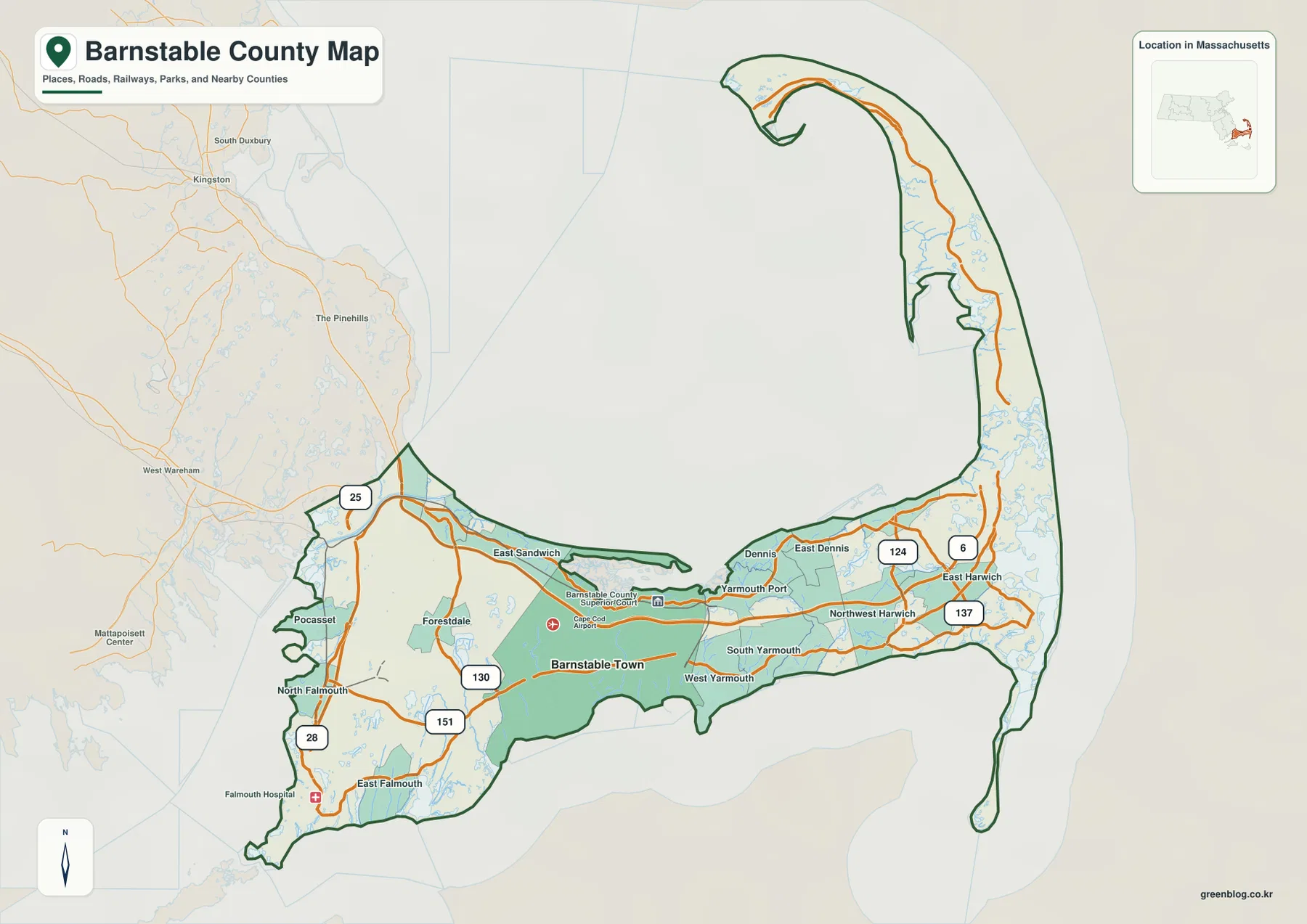
Route 6 is the clearest road reference for following the county from west to east. On the supplied map it runs through the central part of the Cape, passing the Sandwich and Barnstable area before continuing through Yarmouth and Dennis toward the Lower Cape. The road helps organize a county that otherwise has many shoreline bends and local roads. Once Route 6 is located, it becomes easier to judge whether a place lies closer to Cape Cod Bay on the north side or to the southern shoreline facing Nantucket Sound.
The Upper Cape has a different road pattern from the narrow eastern sections. Route 28 is prominent around Falmouth, while Routes 130 and 151 help connect the Forestdale and Falmouth side of the county. In the mid- and lower-Cape portion, Routes 124 and 137 provide north-south links around Dennis and Harwich. These roads do not create one radial network centered on a single downtown. Instead, they connect a sequence of communities stretched along a peninsula whose width and direction keep changing.
Place names also help explain the two-sided nature of the Cape. Yarmouth Port appears nearer the north shore, while South Yarmouth lies closer to Nantucket Sound. East Dennis and East Harwich are set farther along the peninsula, where the distance between the northern and southern shores is relatively short on a county-wide map. A traveler may see these communities as close together, but the actual route still depends on the road network, local intersections, and the shape of the coastline.
The map also shows the mainland context to the west. Plymouth County occupies the area beyond the Cape’s entrance, and Route 25 appears outside Barnstable County near the western approach. Inside the county, the road pattern becomes increasingly tied to the peninsula itself. That contrast is useful because it shows why Cape Cod travel often feels linear at the regional scale even though local movement can involve many north-south and shoreline connections.
Why the city layer highlights only Barnstable Town
The city-distribution map intentionally removes most of the road and place-name detail. Its CITY INDEX contains one ranked major-city marker: Barnstable Town, with the value 49,568 printed beneath the name. The important point is what the layer is designed to show. It is a simplified ranking graphic, not a complete municipal map, so the single marker should not be interpreted as evidence that the rest of Cape Cod has no significant towns or population centers.
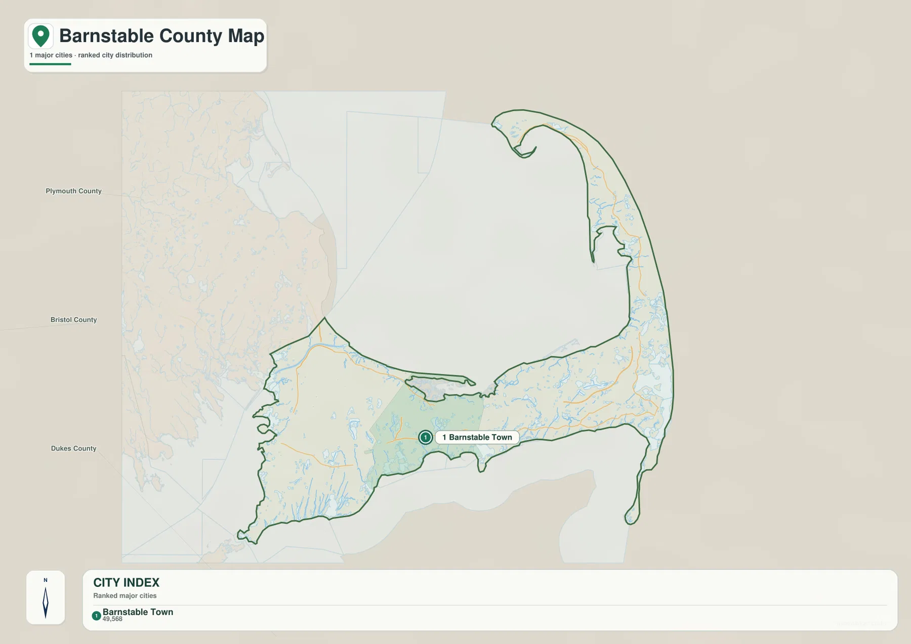
As a location reference, the marker is useful because Barnstable Town sits in the Mid Cape rather than at either extreme of the county. Returning to the general map shows Route 6 nearby, East Sandwich to the west, and Yarmouth to the east. That comparison turns the dot on the city layer into a more meaningful geographic anchor. It also helps a reader estimate how far the Outer Cape extends beyond the county’s main mid-Cape reference point.
Barnstable County’s own regional-government page describes the county as the 15 towns of Cape Cod: Bourne, Sandwich, Falmouth, Mashpee, Barnstable, Dennis, Yarmouth, Brewster, Harwich, Chatham, Orleans, Eastham, Wellfleet, Truro, and Provincetown. That official list is a useful reminder that the city layer and the county’s municipal structure answer different questions. The city layer is selective; the county itself contains a long chain of separate towns from the Upper Cape to the tip of the peninsula.
This makes the simplified layer most useful for orientation rather than completeness. Find Barnstable Town first, then switch back to the general map and compare its position with Falmouth, Sandwich, Dennis, and Harwich. The gap between the western entrance and the far Outer Cape becomes easier to appreciate when one fixed reference point is used across both maps. For municipal boundaries, local streets, or every community name, a more detailed official map should be used instead.
Cape Cod Bay, Nantucket Sound, the Atlantic, and a network of short rivers
Water defines Barnstable County as strongly as roads do. Cape Cod Bay fills the large inner curve on the north side of the peninsula, while the Atlantic Ocean lies along the exposed eastern shore. Nantucket Sound extends across much of the southern side, and Vineyard Sound appears near Falmouth in the southwest. Buzzards Bay is shown west of the Cape. Seeing all of these water bodies on one map explains why the county has multiple coastal orientations rather than one continuous shoreline facing a single sea.
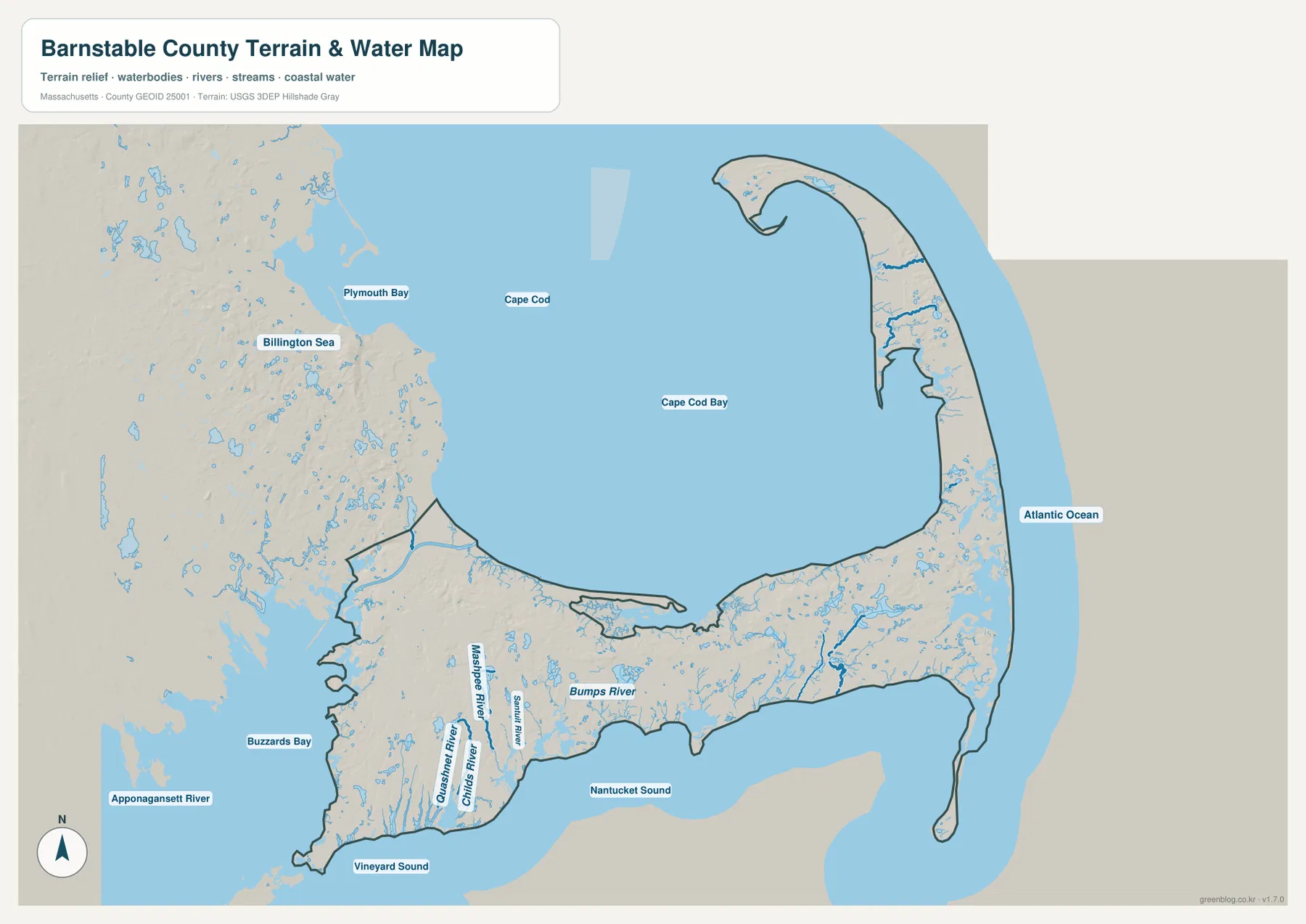
The southwestern part of the county contains several named river systems on the supplied map. Mashpee River runs toward the south shore, while Quashnet River and Childs River lie farther west. Santuit River appears nearby, and Bumps River is labeled farther east toward the Barnstable side of the southern coast. These are short coastal drainage systems rather than long interior rivers. Their compact scale fits the peninsula, where many streams, ponds, and wetlands lie only a limited distance from salt water.
The relationship between Cape Cod Bay and Nantucket Sound is especially clear through the Mid Cape. Around Yarmouth, Dennis, and Harwich, the land between the north and south coasts is not very wide on a county-scale map. Farther west, the Falmouth and Mashpee side has a broader, more irregular shoreline with several river mouths and protected coastal inlets. The changing width of the peninsula is one reason the same road can feel inland in one section and close to major water bodies in another.
The Outer Cape adds another change in direction. The peninsula turns north along the Atlantic side and then bends again near its tip, wrapping around the eastern edge of Cape Cod Bay. The water map makes that hook easier to interpret because the bay and ocean are drawn as large continuous surfaces. On a road-heavy map, the viewer may focus on the route line; on the water map, the reason for the route’s curved regional path becomes much more obvious.
This layer should be read as a geographic water reference rather than a hazard or navigation chart. The blue lines and areas do not establish flood zones, wetland jurisdiction, channel depth, boating safety, or legal shoreline boundaries. For those questions, the appropriate agency data must be consulted. At county scale, the map is most useful for understanding how Cape Cod Bay, Nantucket Sound, Vineyard Sound, Buzzards Bay, the Atlantic, and the short river systems fit together around the land.
Reading the county from Upper Cape to Outer Cape
Barnstable County’s official description groups its 15 towns into Upper Cape, Mid Cape, Lower Cape, and Outer Cape. The supplied maps do not draw those regional divisions as formal boundaries, but the terms are useful for keeping track of a county that changes shape over a long distance. The Upper Cape begins around Bourne, Sandwich, Falmouth, and Mashpee. Barnstable, Yarmouth, and Dennis form the Mid Cape; Brewster, Harwich, Chatham, and Orleans are farther east; and Eastham, Wellfleet, Truro, and Provincetown continue along the Outer Cape.
The road map supports this sequence. In the west, Falmouth-area routes spread across a broader piece of land. Around Barnstable and Yarmouth, Route 6 becomes a strong central reference. Farther east, the road corridor is increasingly constrained by the narrow peninsula and the proximity of major water bodies on both sides. That progression is more informative than treating the entire county as one uniform strip, because each section has a different relationship between roads, settlements, and shoreline.
Cape Cod Bay can serve as a helpful orientation feature. Communities on the north side face the bay, while the southern side of Falmouth, Mashpee, Barnstable, Yarmouth, Dennis, and Harwich is oriented toward Vineyard Sound or Nantucket Sound. Beyond the elbow of the Cape, the Atlantic becomes increasingly prominent. Using these large water bodies as directional anchors can be easier than relying only on compass directions because the peninsula curves so much that “east” and “north” change practical meaning from one section to another.
Matching Barnstable Town, Falmouth, and the coast across the three maps
A simple way to compare the set is to choose one place and find it repeatedly. Barnstable Town works well because it appears as the single marker on the city map and as a named place on the general map. After locating it, trace Route 6 nearby and compare East Sandwich to the west and Yarmouth to the east. Then open the water map and note Cape Cod Bay to the north and Nantucket Sound to the south. That three-step comparison connects settlement, road, and coastal geography without requiring every label at once.
Falmouth gives a different perspective. The general map shows North Falmouth and East Falmouth with Routes 28 and 151 nearby. The water map then reveals why the southwestern coastline is so irregular: Buzzards Bay lies to the west, Vineyard Sound lies to the south, and several short rivers run toward the coast. The place is therefore easier to understand as a peninsula within a peninsula, with multiple water edges shaping the local road and settlement pattern.
For the eastern half, follow Route 6 through Dennis and toward Harwich before comparing the water map. Cape Cod Bay remains on the inside of the curve while the Atlantic side becomes increasingly close as the land narrows. Routes 124 and 137 are useful local north-south references around the Dennis-Harwich area. The general map is better for identifying those roads, while the water map explains why there is relatively little land between the two coasts in parts of the Lower Cape.
For print or presentation work, choose the map that matches the question instead of placing every layer on one page. Use the general county map for roads and named communities, the city layer when a simple Barnstable Town reference is needed, and the terrain-and-water map for Cape Cod Bay, the sounds, the Atlantic, rivers, ponds, and shoreline shape. Because the three graphics share the same county outline, readers can move from one map to another without losing the overall geographic frame.
Current travel decisions should still rely on up-to-date transportation and navigation information. Route numbers are useful geographic anchors, but construction, closures, access rules, and travel times can change. The same caution applies to water information. The supplied maps are designed to explain Barnstable County at a broad county scale; specialized engineering, regulatory, boating, or hazard questions require the corresponding official datasets and local guidance.
Frequently Asked Questions
Why does the city map show only Barnstable Town?
The supplied city layer is a selective ranking map rather than a complete municipal map. Its CITY INDEX lists Barnstable Town as the single ranked major-city point. Barnstable County itself includes 15 Cape Cod towns, so use the general map and official county information when you need the broader municipal context.
Which map is best for following Route 6 across Cape Cod?
Use the general county map. It shows Route 6 as a strong west-to-east reference through the central Cape and lets you compare it with Routes 28, 130, 151, 124, and 137. For actual driving, check current transportation or navigation information because closures, construction, and travel conditions can change.
Can Cape Cod Bay and Nantucket Sound be compared on the same map?
Yes. The terrain-and-water map shows Cape Cod Bay to the north, Nantucket Sound to the south, the Atlantic Ocean to the east, and Vineyard Sound and Buzzards Bay near the southwest. It also labels several local rivers, but it is a geographic reference map rather than a flood, navigation, depth, or regulatory map.
Map File Information
The ZIP contains the original high-resolution JPG versions of the general county, city-distribution, and terrain-and-water reference maps discussed on this page.
- Included Files: general county map, city-distribution map, terrain-and-water reference map
- File Type: JPG
Related Maps
Sources and references
These official resources are useful for checking Barnstable County’s town structure, road data, boundaries, and hydrography.
- Barnstable County – About the County
- MassGIS – MassDOT Roads
- U.S. Census Bureau TIGER/Line Shapefiles
- USGS National Hydrography
Green Map creates custom-edited map images using open geographic data sources such as geoBoundaries, Natural Earth, OpenStreetMap, and government open data. These maps are edited visual materials, not raw data files, and are provided for education, documents, presentations, and graphic reference.