Saunders County occupies a broad part of east-central Nebraska, with Wahoo near the middle, Ashland and Yutan closer to the Platte River on the east, and smaller communities spread across the western and southern countryside. This Saunders County Map page combines the county boundary and major roads with the locations of Wahoo, Ashland, Yutan, Ceresco, Cedar Bluffs, and Mead, plus the Platte River, Wahoo Creek system, and the elevation contrast between higher western hills and lower river country. The WebP images are intended for quick viewing, while the same four maps are available below as high-resolution JPG files in one ZIP archive. High-resolution map files are available for download in the section below.
Wahoo is the easiest starting point for reading the county. Ashland sits in the southeast near a large bend of the Platte River, Yutan lies to the east, Ceresco is near the southern edge, and Cedar Bluffs is close to the northern river boundary. Prague, Malmo, and Weston provide reference points farther west, while Colon, Mead, and Ithaca fill in the central and eastern countryside. Together these places show a county that is rural and widely settled but still organized around several clear road and water corridors.
Table of Contents
Roads radiating from Wahoo toward Ashland, Yutan, and Cedar Bluffs
The general county map makes Wahoo the central reference point. Route 92 crosses the county from west to east through the Wahoo area, while 77 and 16 provide important north-south connections nearby. East of Wahoo, the road network reaches Mead and Yutan; northward it passes Colon and continues toward Cedar Bluffs. The arrangement shows why Wahoo functions as both the county seat and a convenient geographic center for comparing several parts of Saunders County.
Ashland occupies the southeast near a major bend in the Platte River, with Route 63 in the area. Prague, Malmo, and Weston are spaced across the western side, while Ceresco sits near the southern boundary. These communities give the map a different pattern from a county where most settlement follows one highway or river valley: Saunders County has several distinct clusters linked by a web of state and local roads.
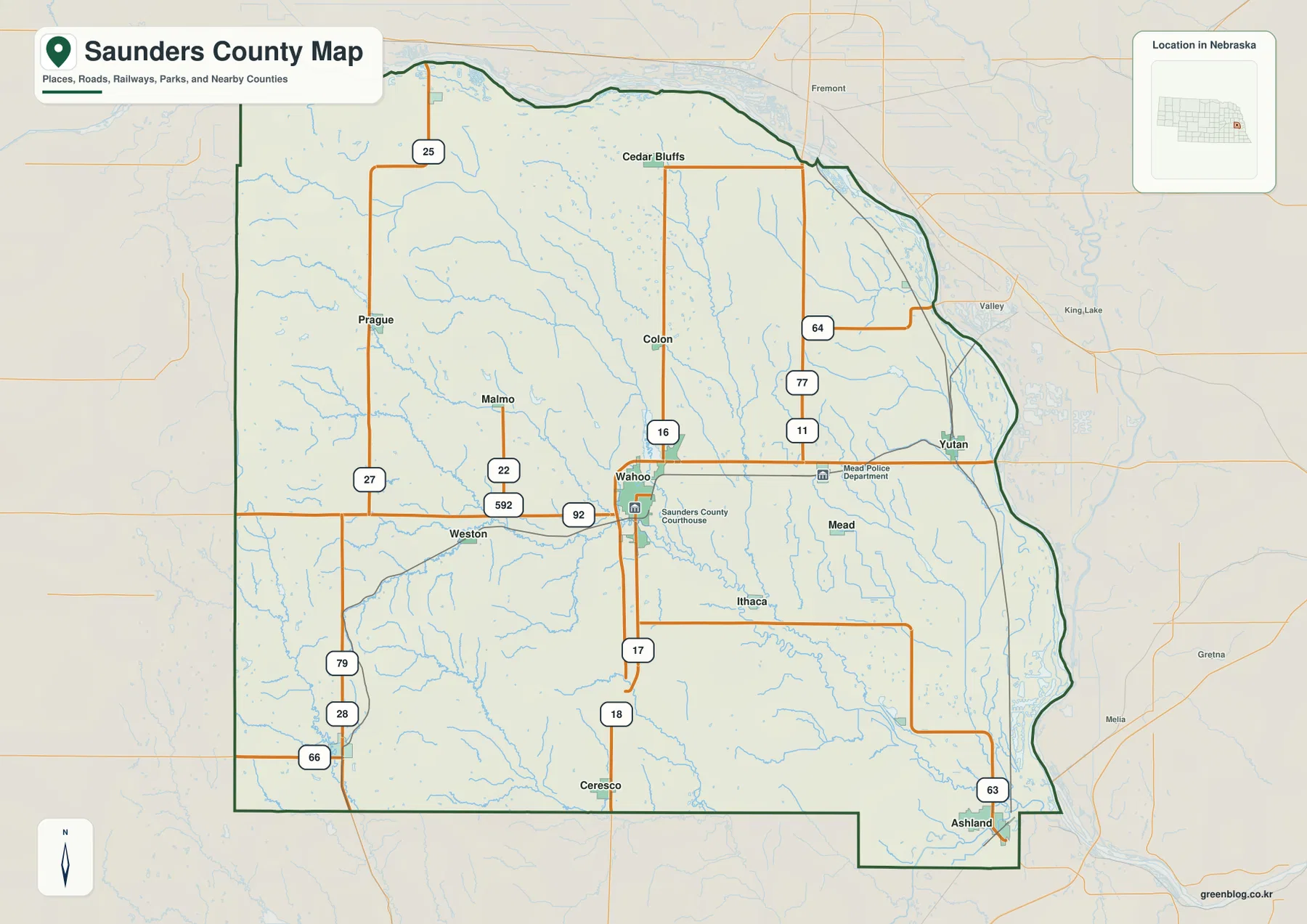
The official Saunders County website identifies Wahoo as the county seat and lists Ashland, Cedar Bluffs, Ceresco, Colon, Ithaca, Malmo, Mead, Prague, Valparaiso, Weston, Yutan, and other communities within the county. Most of those names appear on the supplied map. Nearby labels such as Fremont, Valley, and Gretna are useful for orientation but lie outside the county boundary, so the dark outline should be used when distinguishing local communities from surrounding places.
This is a regional reference rather than a live navigation product. Construction, detours, and seasonal road conditions can change after a static map is made. For current driving, use up-to-date transportation or navigation information. The map is most useful for questions such as how Wahoo relates to Ashland, which direction Yutan lies from the county seat, or where the western communities sit relative to the Platte River side.
Six major communities spread from Cedar Bluffs to Ashland
The city-distribution graphic removes most road detail and highlights six larger places. Wahoo ranks first near the middle of the county, Ashland sits in the southeast, and Yutan lies to the east. Ceresco anchors the south, Cedar Bluffs the north, and Mead fills the space east of Wahoo. The simplified layout makes the county’s settlement pattern easy to grasp without the visual competition of road numbers and numerous smaller place labels.
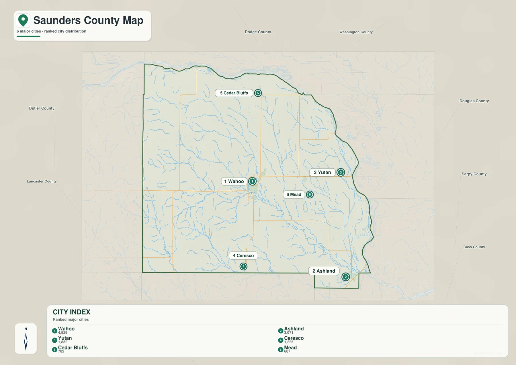
The ranking panel places Wahoo first, followed by Ashland and Yutan, with Ceresco, Cedar Bluffs, and Mead completing the six-place comparison. Readers who need current population totals should consult the latest Census or municipal estimates rather than treating the graphic as a live statistical table. For map reading, the more useful point is the spacing: Wahoo is central, Ashland and Yutan are oriented toward the east, and Ceresco and Cedar Bluffs define opposite sides of the county.
When the city map is paired with the terrain views, the settlement pattern gains additional context. Ashland and Yutan are closer to the lower Platte River side, while Wahoo and the western communities lie farther inland on higher rolling ground. Ceresco is near the southern boundary, and Cedar Bluffs is close to the northern Platte corridor. These differences help explain why a single county can contain both river-bottom landscapes and much more dissected upland terrain.
The Platte River boundary and a network led by Wahoo Creek
The water map is dominated by the Platte River. It follows the northern edge of Saunders County and then bends southward along the eastern side toward Ashland. The official county profile likewise describes the Platte as forming the county’s northern and eastern borders. That long river boundary explains the county’s curved northeastern outline and the broad lowland visible along the same side of the elevation map.
Inside the county, Wahoo Creek crosses the central area and receives water from North Fork Wahoo Creek and Cottonwood Creek farther west. Sand Creek and Otoe Creek drain toward the northern and eastern Platte corridor, while Silver Creek creates another prominent north-south valley through the central-east. Johnson Creek and Clear Creek appear closer to Ashland, and Marble Creek and Rock Creek help define the southwestern drainage network.
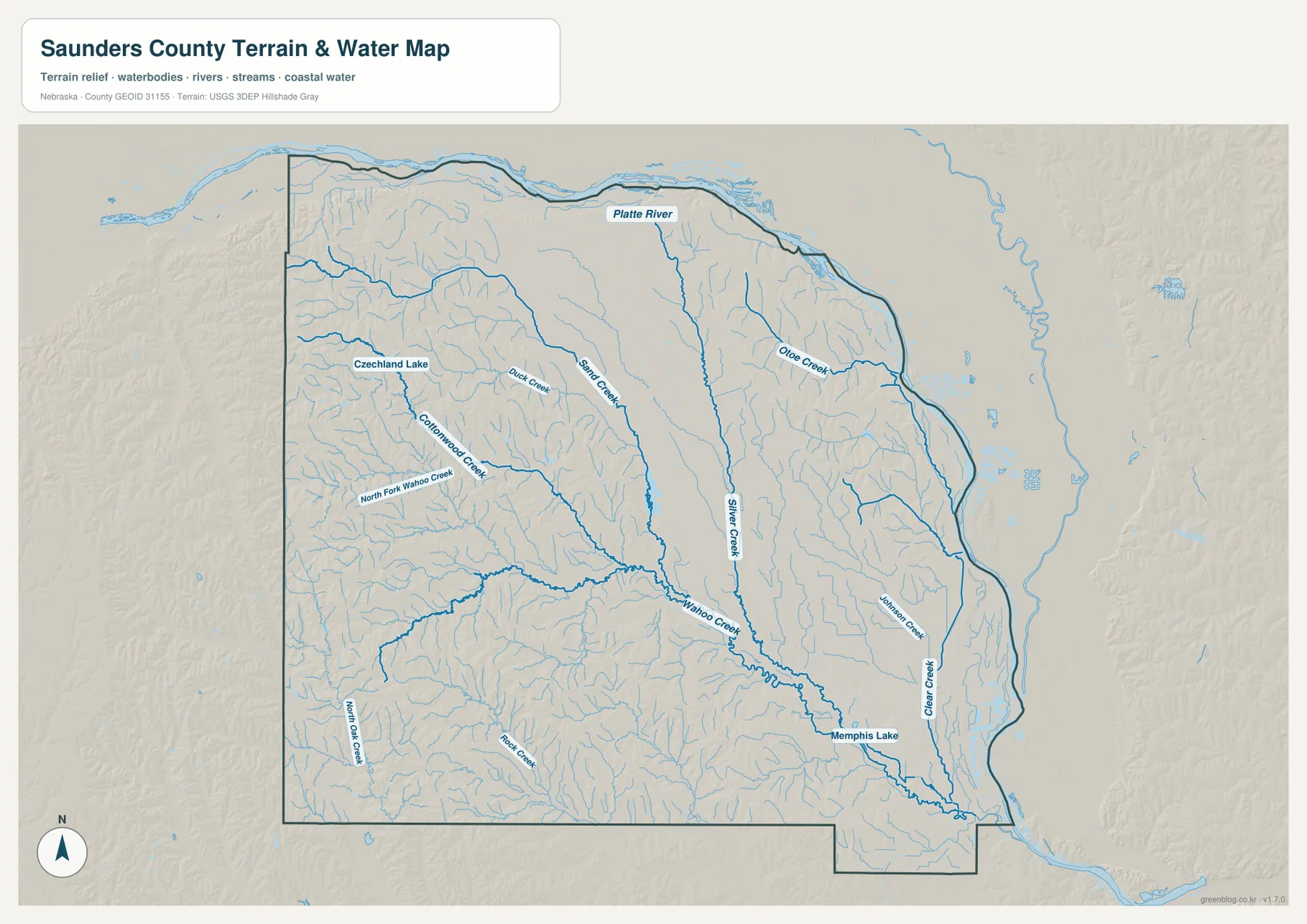
Czechland Lake and Memphis Lake are also labeled on the map. They provide useful orientation points within the broader creek network, but the image does not show current water levels, water quality, fishing access, or recreation status. Anyone planning a visit should consult the managing park or local agency for current conditions rather than relying on a static geographic reference.
Blue line width and color do not measure discharge, depth, or flood hazard. Floodplain decisions, land restrictions, stream access, and other safety questions require current official products from FEMA, USGS, or relevant local agencies. For county geography and teaching, however, the map is effective because it places the Platte River and the interior creek network in one consistent view.
Higher western hills descending toward the Platte River lowlands
The elevation map shows one of the county’s clearest geographic contrasts. The western edge contains broad brown and orange uplands, while green becomes more common toward the center and especially along the Platte River to the north and east. The displayed surface ranges from about 319 to 499 meters, with a mean near 392 meters. The important pattern is the overall descent from the higher western country toward the river valley.
Wahoo Creek forms a long lower corridor through the middle of the county, and Silver Creek creates another pronounced low strip farther east. Near Ashland, the terrain drops into the broad Platte River lowland. The west and southwest, by contrast, contain many narrow ridges and tributary valleys, producing a much more textured surface than the comparatively flat river-bottom area.
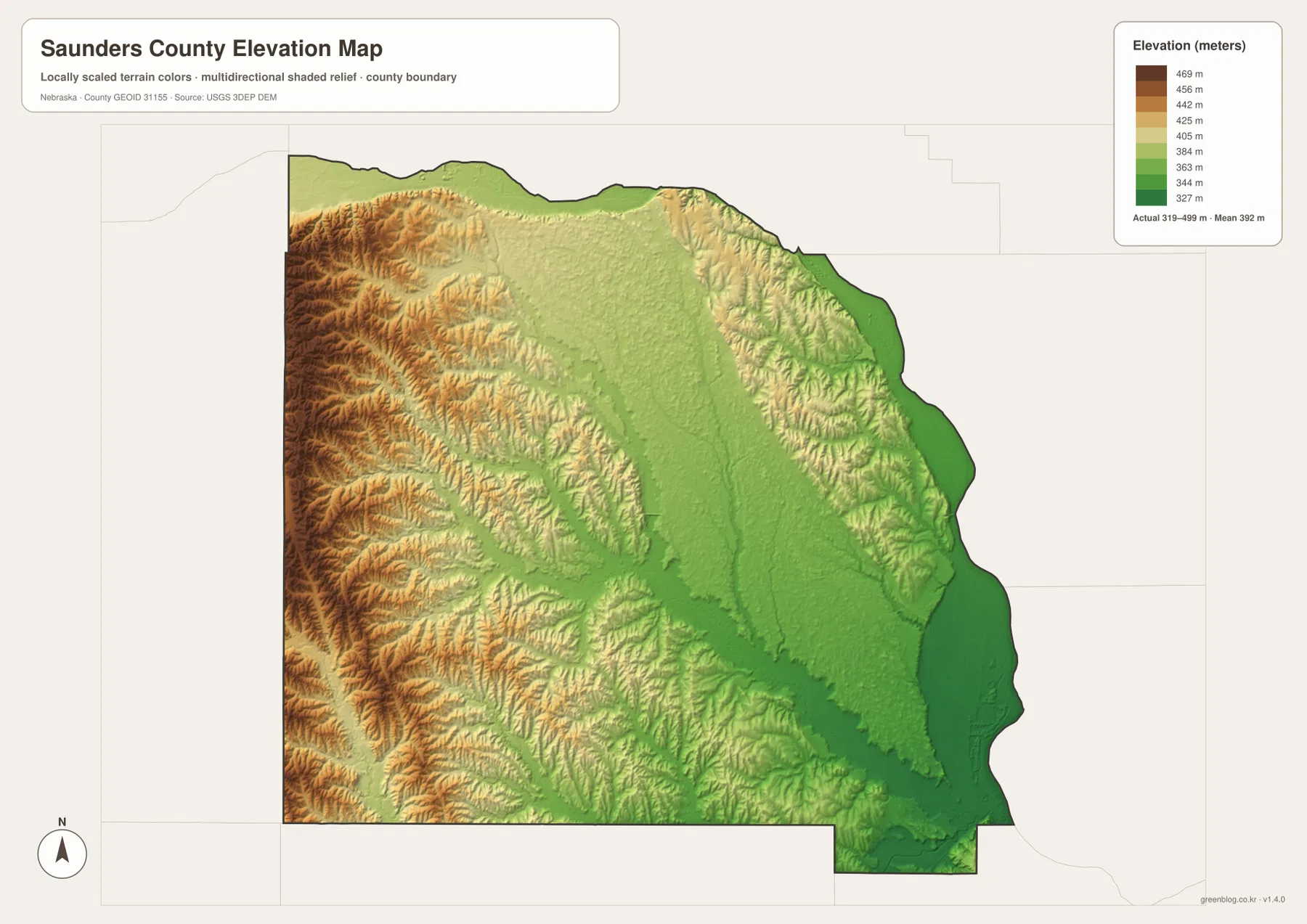
The county’s comprehensive planning document describes a landscape of bottomland, plains, and rolling land that generally slopes toward the Platte River valley. That description matches the supplied elevation image: the strongest relief is in the west, while the northern and eastern edges flatten into the river corridor. Ashland and Yutan sit closer to that lower terrain, whereas Wahoo and western communities occupy more elevated interior ground.
This elevation surface is designed for county-scale comparison, not parcel surveying or engineering. It should not be used to establish exact site elevations, road grades, construction benchmarks, or drainage design values. Those purposes require the source data from the USGS 3D Elevation Program, professional surveying, or another appropriate technical source.
From Ashland’s early county-seat role to centrally located Wahoo
The official county history says the area was created in 1856 as Calhoun County and renamed Saunders County in 1862 in honor of territorial governor Alvin Saunders. Ashland became the first county seat after early elections, but in 1873 voters selected the more centrally located Wahoo. The modern map makes that change easy to understand geographically: Ashland sits at the southeast edge, while Wahoo lies much closer to the middle of the county.
Wahoo remains the county seat today. The county’s historical page also notes competing explanations for the name “Wahoo,” including a reference to a medicinal plant growing along Wahoo Creek and another interpretation tied to local terrain. Regardless of which explanation is preferred, the modern map gives the name a visible geographic connection because Wahoo Creek passes through the same central part of the county as the city.
The official profile reports roughly 760 square miles of total area and a 2020 Census population of 22,278. Much of Saunders County remains rural, so communities are widely spaced even though the county lies between the larger Omaha and Lincoln metropolitan areas. Ashland, Yutan, and Ceresco occupy the side of the county closest to those major population centers, while the western communities extend into a more agricultural and rolling landscape.
Choosing the best view for printing, teaching, or county comparison
Use the general county map when roads, communities, and the boundary need to be seen together. Wahoo is the natural starting point, followed by Ashland, Yutan, Ceresco, and Cedar Bluffs. The city-distribution graphic is cleaner when the goal is simply to compare the six larger communities without the detail of the road network.
The water map is the better choice for tracing the Platte River, Wahoo Creek, Silver Creek, and smaller tributaries. The elevation image then explains why the river edge is low and why the western part of the county contains stronger relief. In a classroom, students can locate the major towns first, trace the Platte boundary next, and then compare the same areas on the elevation view.
High-resolution JPG files are better suited to printing and close inspection when small stream names and route numbers matter. These maps remain regional references rather than legal or safety documents. County boundaries can be checked against Census TIGER/Line data, waterways against USGS National Hydrography, and elevation against the USGS 3D Elevation Program.
Frequently Asked Questions
Which map is easiest for comparing Wahoo, Ashland, and Yutan?
The city-distribution map is the simplest choice because it highlights six major communities without most road detail. Wahoo is central, Ashland lies in the southeast, and Yutan is to the east. Use the general county map when route numbers and smaller communities also matter.
Which sides of Saunders County are bordered by the Platte River?
The Platte River follows the northern edge and then bends south along much of the eastern side toward Ashland. The water map also shows Wahoo Creek, Silver Creek, Otoe Creek, Clear Creek, and several smaller tributaries inside the county.
Can the elevation map be used for surveying or construction design?
No. It is intended to compare higher western hills with lower river and creek valleys at county scale. Exact site elevations, engineering grades, and legal survey values require appropriate USGS source data or professional surveying.
Map File Information
Download the four high-resolution JPG maps shown on this page for Saunders County in one ZIP archive.
- Included Files: Use only the versions confirmed in the article and supplied images
- File Type: Use the confirmed download contents
- Intended Use: Printing, education, presentations, and map-based projects
Related Maps
Sources and references
County-seat, community, area, population, history, and terrain background comes from official Saunders County sources. The federal links below provide authoritative references for boundaries, hydrography, and elevation data.
- Saunders County – About Our County
- Saunders County – Official Website
- U.S. Census Bureau – TIGER/Line Shapefiles
- USGS – National Hydrography
- USGS – 3D Elevation Program
Green Map creates custom-edited map images using open geographic data sources such as geoBoundaries, Natural Earth, OpenStreetMap, and government open data. These maps are edited visual materials, not raw data files, and are provided for education, documents, presentations, and graphic reference.