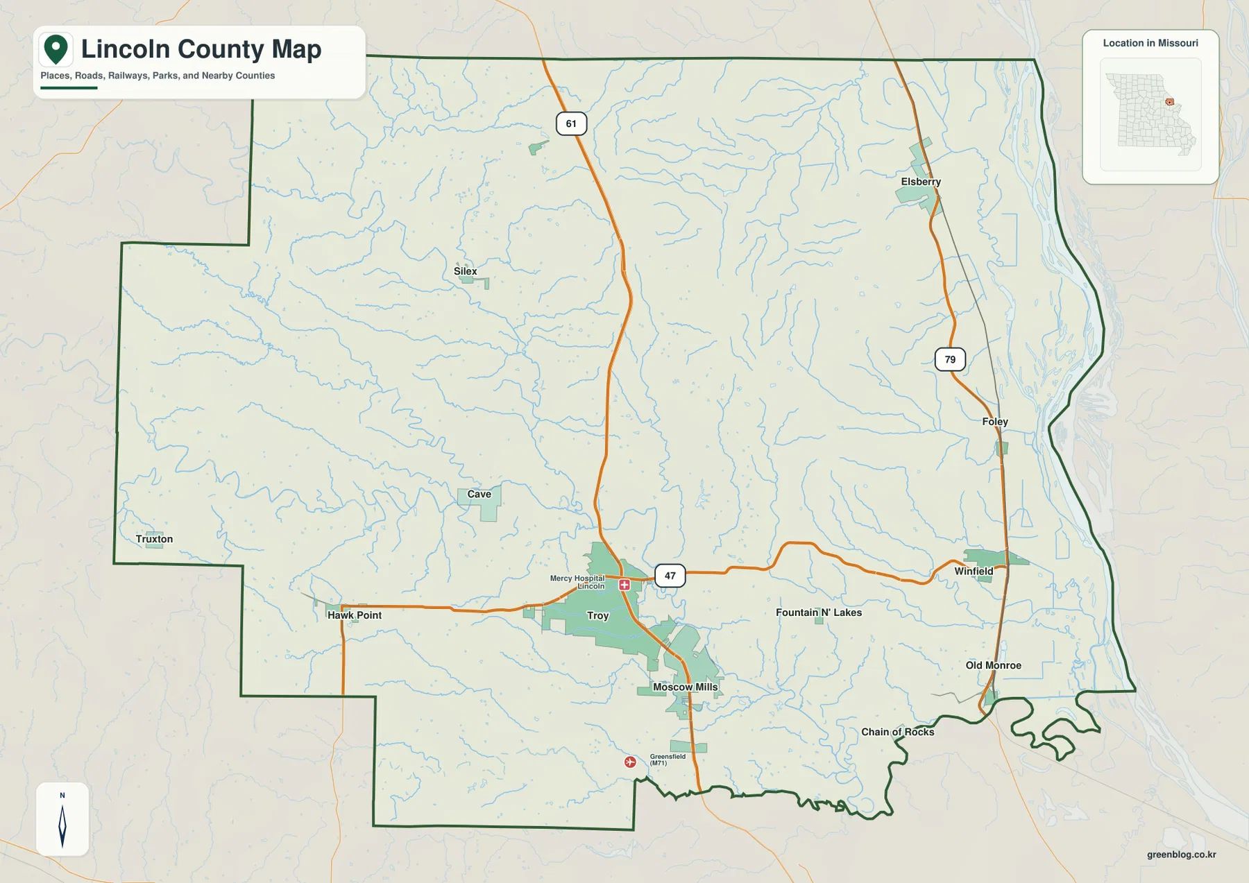
Lincoln County lies northwest of St. Louis and reaches eastward to the Mississippi River, with Troy serving as the main inland center. Moscow Mills sits immediately south of Troy, while Winfield and Elsberry occupy the eastern side and Hawk Point and Silex spread across the west. The Cuivre River system cuts deep valleys through the interior, contrasting with the broad Mississippi lowlands along the county’s eastern edge. The elevation layer ranges from about 98 to 300 meters. High-resolution JPG versions of the map themes are available together in the ZIP below for printing, enlargement, or offline reference. High-resolution map files are available for download in the section below.
A useful way to understand Lincoln County is to begin with Troy and Moscow Mills, then compare them with Winfield and Elsberry near the river. U.S. 61 and Route 47 organize the central road network, while Route 79 follows the eastern side. The water and elevation layers reveal the deeper pattern: Cuivre River branches carve green valleys into the Lincoln Hills, while the Mississippi corridor drops into much lower and flatter terrain.
Table of Contents
Troy and Moscow Mills form the strongest inland urban cluster
Troy is the largest mapped city and sits in the south-central portion of the county. U.S. 61 runs north-south just west of the developed area, and Route 47 crosses through Troy toward Winfield in the east and Hawk Point in the west. Moscow Mills lies directly south, creating the county’s most continuous urban cluster and one of its clearest road corridors.
Lincoln County’s official government website places county administration at 201 Main Street in Troy. The County Clerk, Commission, Assessor, and other offices are centered in the city, reinforcing Troy’s role as both the map’s main urban reference and the county’s administrative center.
Elsberry and Winfield organize the Mississippi River side
Elsberry lies in the northeastern part of the county close to Route 79, while Winfield is farther south on the eastern side. Foley and Old Monroe appear even closer to the Mississippi corridor, and Route 79 links much of this river-facing side from north to south. These communities make the eastern edge easy to distinguish from the inland Troy corridor.
The terrain setting also changes sharply. Mississippi bottomlands are lower and broader than the country around Troy, yet the ground rises quickly to the west. Around Winfield and Old Monroe, the transition from floodplain to rolling upland happens over a relatively short distance, producing one of the county’s clearest elevation contrasts.
The ranked city layer places Troy first and spreads the others in several directions
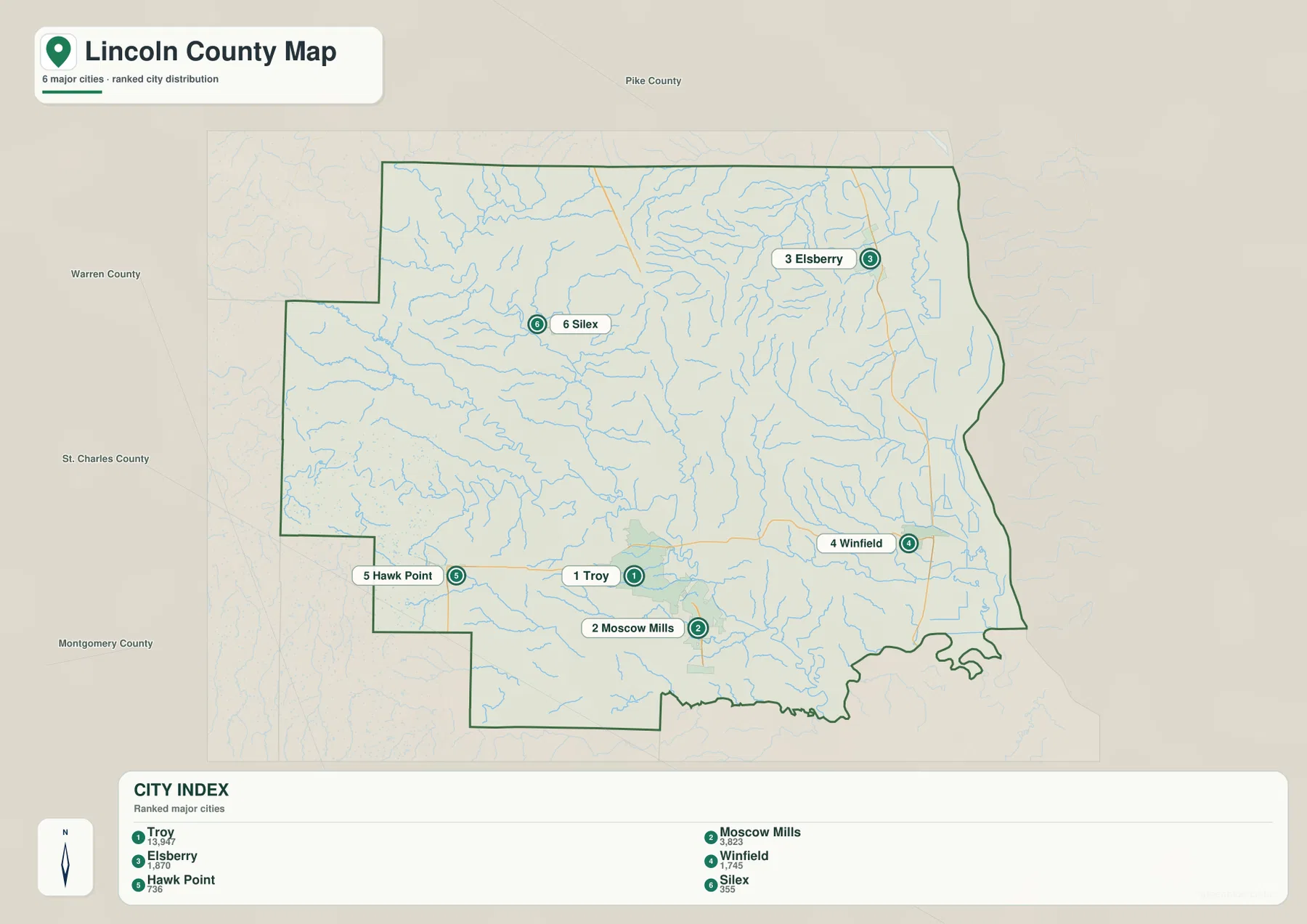
The city distribution map ranks Troy first, Moscow Mills second, Elsberry third, Winfield fourth, Hawk Point fifth, and Silex sixth. The CITY INDEX values are 13,947 for Troy, 3,823 for Moscow Mills, 1,870 for Elsberry, 1,745 for Winfield, 736 for Hawk Point, and 355 for Silex. These values belong to the supplied mapping dataset and should not be treated as current official population estimates.
The spatial pattern matters more than the raw values. Troy and Moscow Mills cluster in the south-central county, Elsberry and Winfield sit in the east, Hawk Point lies southwest, and Silex is northwest. The numbered markers show rank only; they do not represent road mileage or travel time.
North Fork and West Fork Cuivre River divide the central uplands
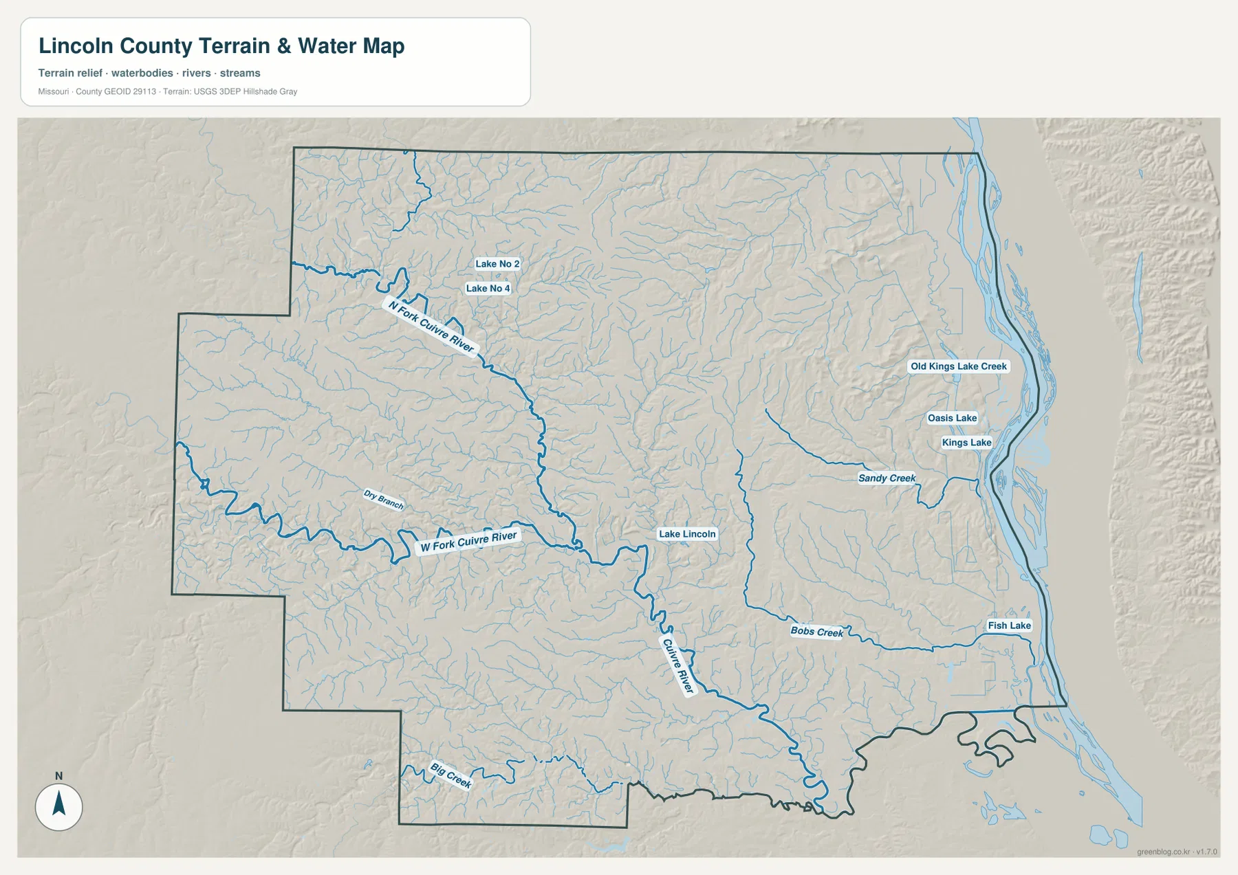
The interior water map is dominated by the Cuivre River system. North Fork Cuivre River descends from the northwest toward the center, while West Fork Cuivre River winds in from the west. Numerous tributaries, including Dry Branch, feed these channels and create a dense network of valleys north and west of Troy.
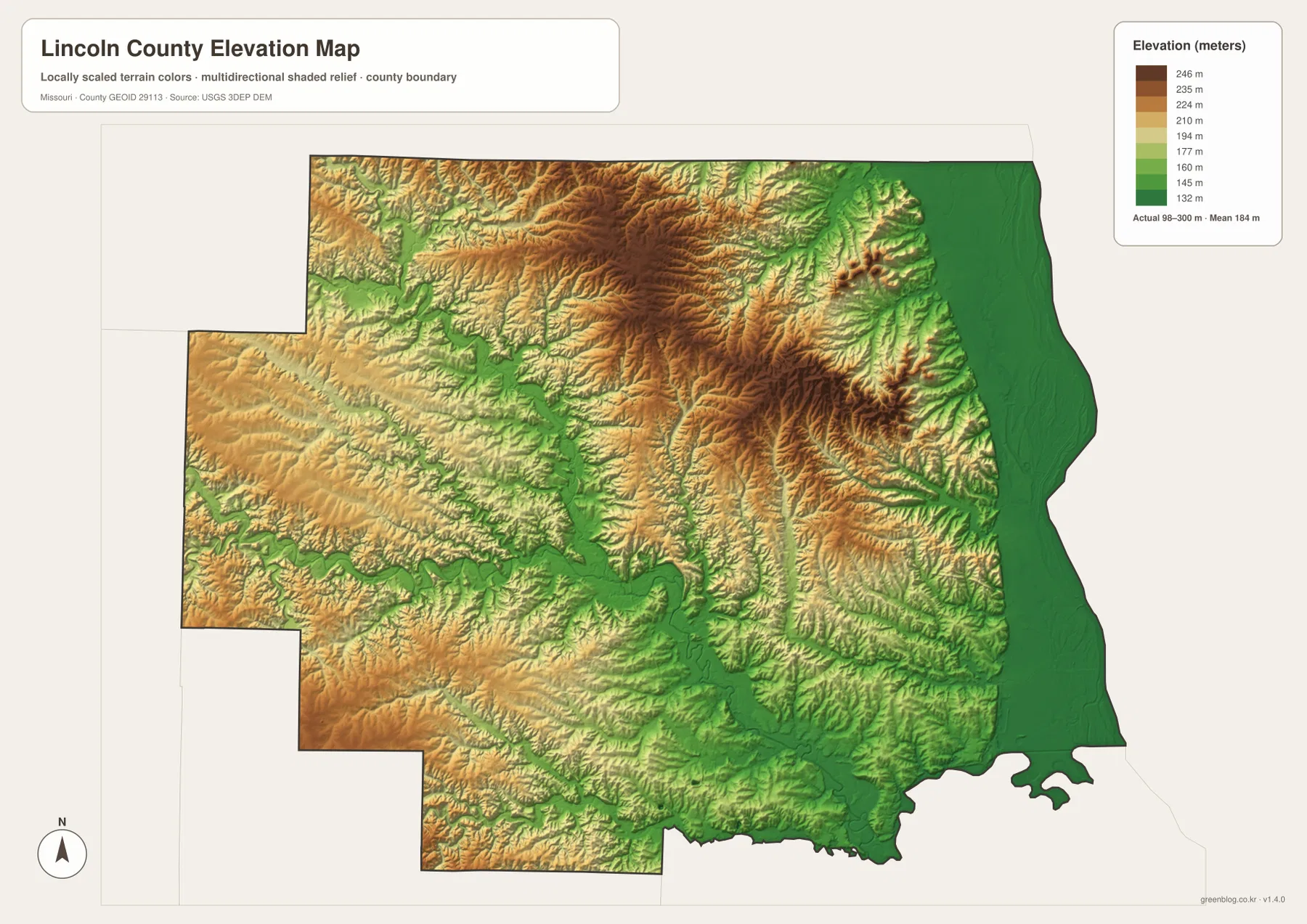
The elevation layer makes the effect of the river system easy to see. Cuivre corridors appear as long green lowlands surrounded by tan and brown hills. What can look like gently rolling farm country on the road map is actually broken by repeated stream valleys and narrow ridges, especially across the center and northwest.
The main Cuivre River and Lake Lincoln anchor the terrain north of Troy
After the major forks come together, Cuivre River continues through the south-central county toward lower terrain farther east and southeast. Lake Lincoln is labeled near the river system and provides a useful landmark close to Troy and the state park area. The river corridor remains distinctly lower than the ridges around it.
Cuivre River State Park is one of Lincoln County’s most distinctive public landscapes. Missouri State Parks describes it as one of the state’s larger and more rugged parks, with an Ozark-like character unusual for northern Missouri. Lake Lincoln supports swimming, boating, and fishing, while the park also offers extensive hiking, backpacking, and equestrian opportunities.
Sandy Creek and Bobs Creek descend toward the eastern lowlands
Sandy Creek crosses the eastern interior between the Elsberry and Winfield side, while Bobs Creek forms another long drainage farther south. Both descend from higher country toward the Mississippi River lowlands and become part of a dense set of east-flowing valleys.
Kings Lake, Oasis Lake, Fish Lake, and Old Kings Lake Creek are also labeled on the eastern side. These smaller water features contrast with the narrow inland river valleys and help show how the Mississippi floodplain contains old channels, lakes, and broad low areas. The map is a geographic reference, not a live flood, river-stage, or navigation product.
Big Creek and western tributaries shape the Hawk Point and Silex side
Big Creek appears in the southwestern part of the county, and many unnamed tributaries branch across the country around Hawk Point. This landscape is more rolling than the Mississippi edge, with low stream corridors separated by broad upland ridges. Route 47 crosses this terrain west of Troy.
The Silex side in the northwest has a similar pattern but includes some of the county’s higher terrain. Comparing the western creeks with the central Cuivre system helps explain why roads and settlements spread along ridges and valley crossings instead of following a perfectly regular grid.
Elevation ranges from about 98 to 300 meters
The elevation layer reports an actual mapped range of approximately 98 to 300 meters, with a mean near 184 meters. The lowest terrain follows the Mississippi River along the eastern edge and the larger stream valleys. Much higher ground appears across the north-central interior and western side, producing more than 200 meters of relief across the county.
Missouri State Parks describes the Lincoln Hills around Cuivre River State Park as a distinctive region where glacial deposits, limestone, bluffs, springs, caves, and sinkholes create terrain that can resemble the Ozarks farther south. The elevation map reflects that ruggedness, especially north and northeast of Troy, where higher ridges stand well above the river valleys.
Cuivre River State Park gives the Lincoln Hills a clear real-world reference
Cuivre River State Park is located near Troy and is a major natural landmark within the county. Missouri State Parks describes its mixture of woodland, prairie, savanna, lake, and rugged stream terrain as giving the area an Ozarkian character despite its northern Missouri location. The park therefore matches the steeply divided terrain visible on the elevation map.
Big Sugar Creek is one of the streams that most strongly shapes the park, while Cuivre River borders part of its southwest side. Lake Lincoln adds a very different setting for boating and swimming. Together, these features provide a useful example of the valleys, ridges, and water bodies shown on the county maps.
Troy is both the road center and the county government center
Lincoln County government offices are concentrated in Troy at and around 201 Main Street. The County Clerk manages commission records, elections, tax-rate certification, and other administrative duties, while the Assessor, Collector, Commission, and additional departments are also based in the city.
The road pattern helps explain Troy’s dominant inland role. U.S. 61 connects the city north and south, Route 47 crosses east-west, and Moscow Mills extends the developed corridor immediately to the south. That differs from Winfield and Elsberry, whose geography is much more closely tied to the Mississippi River side.
Choosing the right downloadable map
Use the general county map for Troy, Moscow Mills, smaller towns, and the primary road network. The ranked city map is best for comparing the six leading communities. The terrain-and-water layer is more useful for tracing the Cuivre River system, eastern creeks, and lakes, while the elevation map makes the contrast between the Mississippi lowlands and the Lincoln Hills especially clear.
The ZIP contains A3 high-resolution JPG files matching the map themes shown on the page. They are useful when labels need to be enlarged or when a printed reference is more convenient. These files do not replace live navigation, flood warnings, legal property boundaries, river-navigation information, or professional elevation surveys.
Frequently Asked Questions
What is the best starting point for reading a Lincoln County map?
Troy is the clearest starting point because it is the county’s main city, county government is based there, and U.S. 61 and Route 47 provide strong road references. From Troy, Moscow Mills, Winfield, Elsberry, Hawk Point, and Silex are easy to orient.
Are the CITY INDEX values current population counts?
No. The values shown for Troy, Moscow Mills, Elsberry, Winfield, Hawk Point, and Silex belong to the supplied mapping dataset. Current official population estimates should be checked separately with the U.S. Census Bureau or another current statistical source.
Where is the strongest terrain contrast in Lincoln County?
The largest contrast is between the Mississippi River lowlands in the east and the higher Lincoln Hills in the north-central interior. The supplied elevation layer spans about 98 to 300 meters, and the Cuivre River valleys form additional low corridors through the uplands.
Map File Information
Download the map files associated with this page for reference, printing, and compatible visual projects.
- Included Files: Use only the versions confirmed in the article and supplied images
- File Type: Use the confirmed download contents
- Intended Use: Printing, education, presentations, and map-based projects
Related Maps
Sources and references
- Lincoln County, Missouri – Official Government Website – county offices and administration in Troy
- Missouri State Parks – Cuivre River State Park – Lake Lincoln, recreation, and park information
- Missouri State Parks – Cuivre River Natural Features – Lincoln Hills, Big Sugar Creek, geology, and habitats
- U.S. Census Bureau TIGER/Line Shapefiles – county boundary and road data
- USGS National Hydrography – rivers, streams, and water features
- USGS 3D Elevation Program – elevation data
Green Map creates custom-edited map images using open geographic data sources such as geoBoundaries, Natural Earth, OpenStreetMap, and government open data. These maps are edited visual materials, not raw data files, and are provided for education, documents, presentations, and graphic reference.