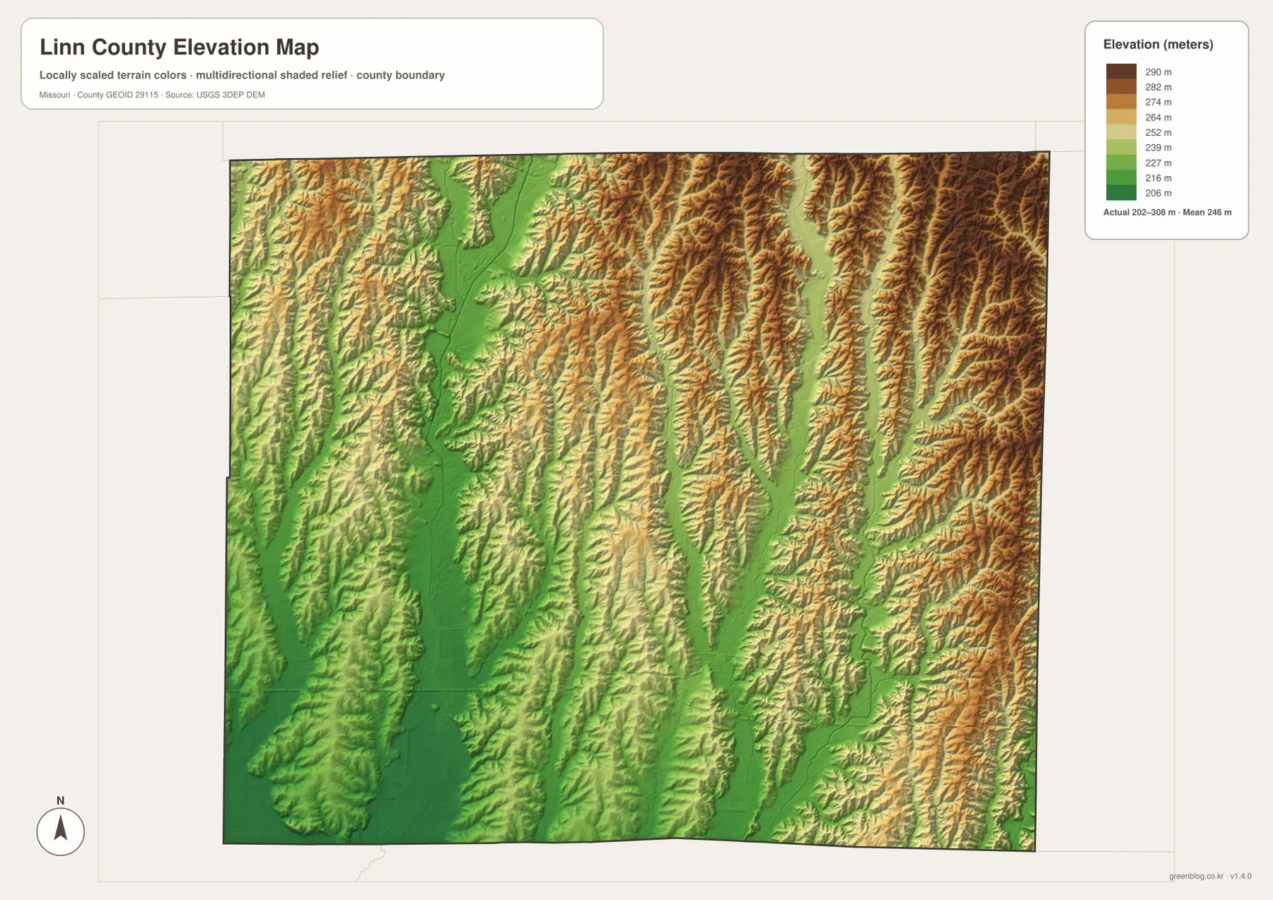
Linn County lies in north-central Missouri, with Brookfield as the largest mapped city and Marceline, Meadville, Bucklin, Laclede, Linneus, and smaller communities spread across a deeply drained rural landscape. U.S. 36 crosses the southern part of the county, Route 5 runs north-south through the west-central interior, and Routes 11, 129, 130, and 139 provide additional regional references. Locust Creek, Muddy Creek, Turkey Creek, and the Yellow Creek branches cut long valleys through the uplands. The elevation map ranges from about 202 to 308 meters. High-resolution JPG versions of the map themes are available in the ZIP below for printing or offline use. High-resolution map files are available for download in the section below.
The easiest way to orient Linn County is to begin with Brookfield and U.S. 36, then compare the nearby towns with Linneus farther north and Marceline at the southern edge. The west and southwest contain broad low stream corridors, while the eastern half rises into more closely spaced ridges. Matching the city, water, and elevation layers makes the county’s terrain much clearer than a road map alone.
Table of Contents
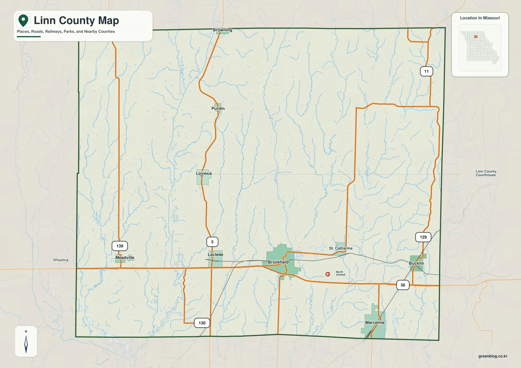
Brookfield and U.S. 36 provide the clearest southern reference
Brookfield is the largest developed area on the general map and sits near the south-central part of Linn County. U.S. 36 passes through the city and continues west toward Laclede and Meadville and east toward Bucklin. St. Catharine is labeled just to the northeast, while Marceline lies farther south near the county line.
Rail lines also cross the Brookfield area and reinforce the east-west pattern of the southern county. Route 5 leads north toward Linneus and Purdin, Route 139 serves the Meadville side, and Route 129 appears near Bucklin. The general map is designed for county-scale orientation rather than live traffic or turn-by-turn navigation.
Linneus is the county seat even though it is not the largest town
Linneus lies northwest of Brookfield along the Route 5 corridor and serves as the county seat. The official Linn County government site lists the courthouse at 108 North High Street in Linneus and provides information for the County Clerk, Commission, Assessor, Collector, and other departments.
The Missouri Secretary of State’s 2025–2026 roster also identifies Linneus as the county seat. That makes the town an important administrative reference even though Brookfield is the larger urban center on the supplied map. Using Brookfield for city orientation and Linneus for county government avoids confusing population prominence with administrative status.
The ranked city layer places Brookfield first and Marceline second
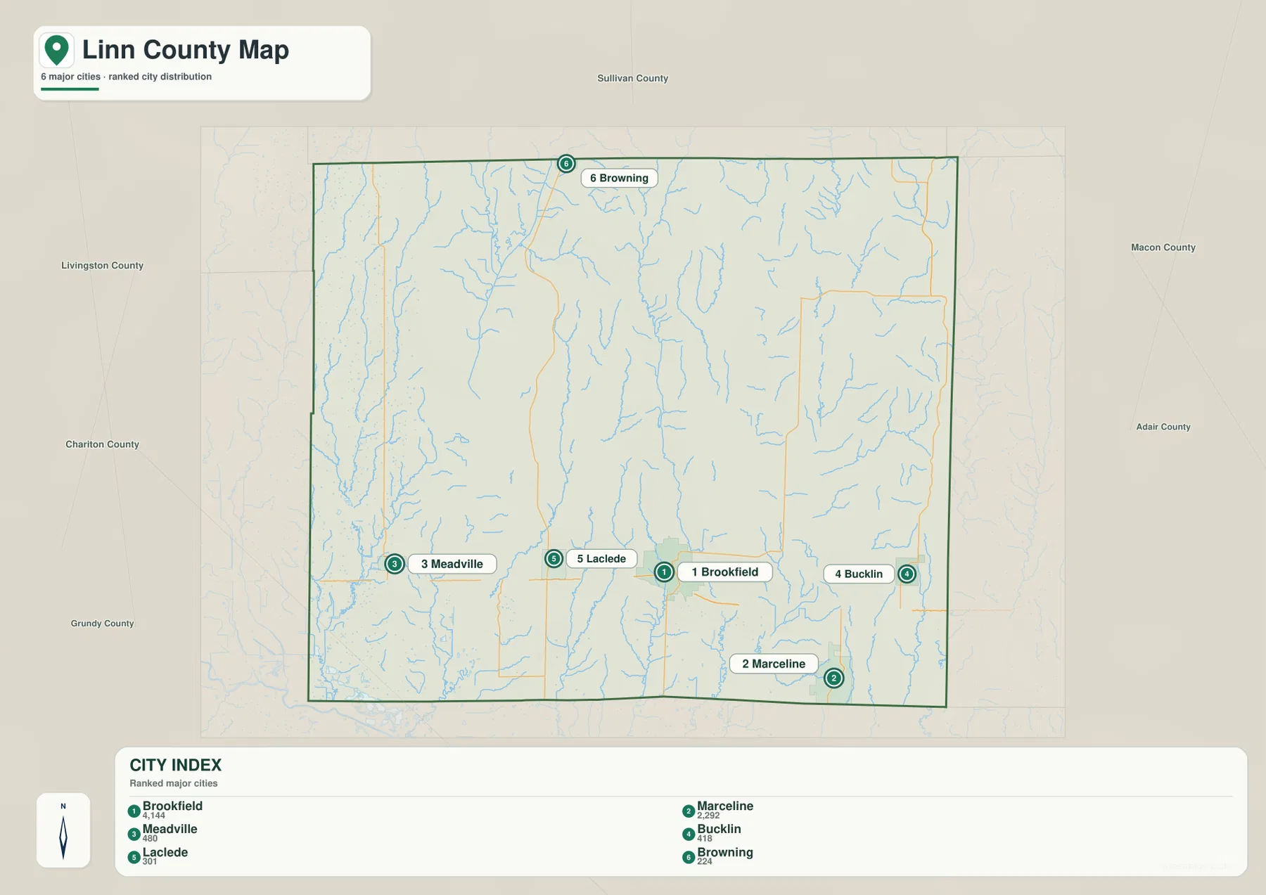
The city distribution map ranks Brookfield first, Marceline second, Meadville third, Bucklin fourth, Laclede fifth, and Browning sixth. The CITY INDEX values are 4,144 for Brookfield, 2,292 for Marceline, 480 for Meadville, 418 for Bucklin, 301 for Laclede, and 224 for Browning. These values belong to the supplied mapping dataset and should not be presented as current official population estimates.
The geography is more useful than the raw numbers. Brookfield lies in the south-central county, Marceline along the southern edge, Meadville and Laclede in the southwest, Bucklin in the southeast, and Browning near the northern edge. The numbered markers show rank only; they do not represent road mileage or travel time.
Locust Creek creates a long low corridor through the western county
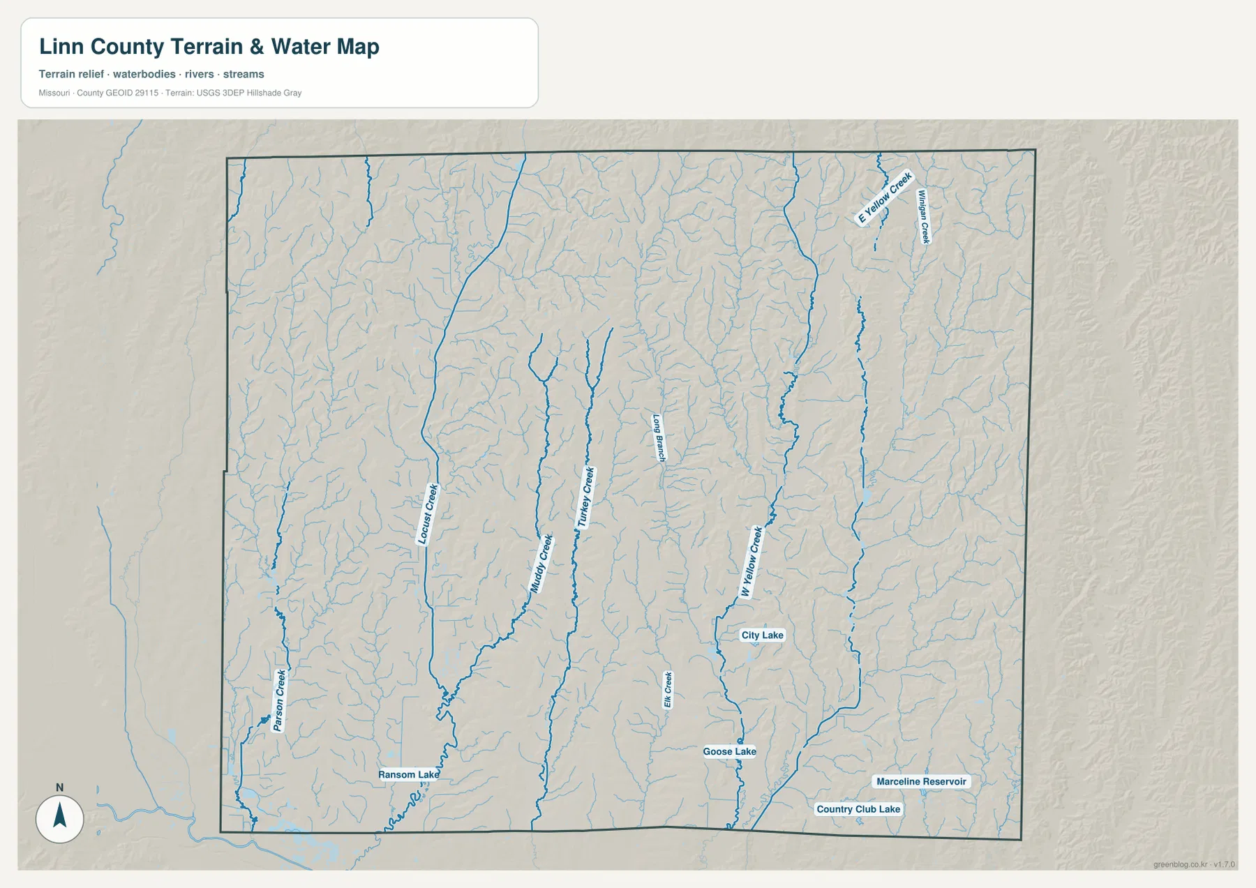
Locust Creek is the most prominent named stream on the western side of the terrain-and-water map. It runs south through the county while collecting many short tributaries, creating a broad lower corridor that stands out clearly on the elevation layer. Ransom Lake is labeled near the southern end of this drainage and provides another useful local reference.
The Locust Creek valley is one of the lowest continuous areas on the map. Higher ridges rise on both sides, so western Linn County is not simply flat farmland. The stream and its floodplain are also central to the natural landscape around Laclede and Pershing State Park.
Pershing State Park preserves a rare section of north Missouri wetland landscape
Pershing State Park lies near Laclede and protects a notable stretch of the Locust Creek floodplain. Missouri State Parks describes a landscape of wet prairie, bottomland forest, oxbow sloughs, cutoffs, marshes, and a naturally meandering portion of Locust Creek. The park is a surviving example of a kind of northern Missouri river landscape that was once much more widespread.
A boardwalk and hiking trails cross the wetland and forest areas, and several small lakes provide additional water features. The park helps explain why the broad green lowland around Locust Creek is different from the narrower tributary valleys farther east. Current trail, camping, and access details should be checked on the state park site before a visit.
Muddy Creek and Turkey Creek divide the central farm country
East of Locust Creek, Muddy Creek and Turkey Creek run for long distances through the county’s central interior. Long Branch and numerous smaller tributaries occupy the ground between them. These waterways break the countryside north and west of Brookfield into repeated ridges and narrow valleys.
On the elevation map, the creek corridors remain green while the surrounding land rises into yellow and tan uplands. The relief is not mountainous, but the density of tributaries creates frequent local changes in height. That terrain also helps explain why rural roads do not always follow a perfectly regular grid.
West Yellow Creek and eastern tributaries cut through higher ground
West Yellow Creek is one of the strongest named waterways in the eastern half of Linn County. East Yellow Creek and Mullen Creek appear farther northeast, while City Lake and Goose Lake provide recognizable local water landmarks. The terrain east of Brookfield and toward Bucklin generally contains more extensive high ground than the Locust Creek side.
Marceline Reservoir and Country Club Lake appear near the southern edge of the water map. These smaller waters do not shape the entire county, but they help match rural places between the road and terrain layers. The water map is intended for general geographic reference and should not be used for current water levels, flood warnings, or legal water-boundary decisions.
Elevation ranges from about 202 to 308 meters
The elevation layer reports an actual mapped range of approximately 202 to 308 meters, with a mean near 246 meters. Locust Creek and the southwestern stream valleys form some of the lowest green terrain. Higher ground becomes more extensive across the east and northeast, where brown and dark tan ridges are closely spaced.
Muddy Creek, Turkey Creek, and West Yellow Creek cut additional green corridors through the interior. The landscape is therefore a sequence of low stream valleys and long upland ridges rather than a single broad plain. The elevation map is useful for county-scale terrain comparison but should not be used as survey-grade or engineering-grade data.
Marceline adds railroad and Walt Disney history to southern Linn County
Marceline developed as a railroad town. Visit Marceline and the Walt Disney Hometown Museum describe the community as a Santa Fe Railway division point founded in 1888 on the Kansas City–Chicago route. The restored Santa Fe depot now houses the Walt Disney Hometown Museum, preserving both railroad and local history.
Walt Disney spent several childhood years in Marceline, and local historical sources describe the town’s Main Street and small-town environment as important influences on his later ideas, including Main Street, U.S.A. The county map is not a tourism map, but placing Marceline beside the railroad and U.S. 36 helps connect this local history to the broader transportation geography of southern Linn County.
Brookfield, Marceline, and Linneus serve different county roles
Brookfield is the strongest road and urban reference on the map, Marceline carries a distinctive railroad and cultural history, and Linneus remains the county’s administrative center. Looking at all three together gives a better picture of Linn County than treating the largest city as the only center.
U.S. 36 ties much of the southern county together, while Route 5 provides the main connection toward Linneus and the northern interior. Between the towns, the terrain is shaped by long creek valleys and agricultural uplands, so the county’s settlement pattern is spread across multiple small centers rather than one continuous urban area.
Choosing the right downloadable map
Use the general county map for Brookfield, Marceline, Linneus, and the main roads. The ranked city map is best for comparing the six leading communities. The terrain-and-water layer is useful for Locust Creek, Muddy Creek, Turkey Creek, the Yellow Creek branches, and local lakes, while the elevation map shows the contrast between lower western valleys and higher eastern ridges.
The ZIP contains A3 high-resolution JPG files matching the map themes shown on the page. They are useful when labels need to be enlarged or when a printed reference is more convenient. These files do not replace live navigation, flood warnings, legal property boundaries, or professional elevation surveys.
Frequently Asked Questions
Is Brookfield the county seat of Linn County?
No. Linneus is the county seat and the Linn County Courthouse is located at 108 North High Street there. Brookfield is the largest city on the supplied ranked-city map and is a major road and service center.
Are the CITY INDEX values current population figures?
No. The values shown for Brookfield, Marceline, Meadville, Bucklin, Laclede, and Browning belong to the supplied mapping dataset. Current official population estimates should be checked separately with the U.S. Census Bureau or another current statistical source.
Where is the lowest terrain in Linn County?
The supplied elevation map shows the Locust Creek and southwestern stream valleys among the lowest areas. The eastern and northeastern county contains more extensive higher ridges, and the full mapped elevation range is about 202 to 308 meters.
Map File Information
Download the map files associated with this page for reference, printing, and compatible visual projects.
- Included Files: Use only the versions confirmed in the article and supplied images
- File Type: Use the confirmed download contents
- Intended Use: Printing, education, presentations, and map-based projects
Related Maps
Sources and references
- Linn County, Missouri – Official Website – county government and courthouse information in Linneus
- Missouri State Parks – Pershing State Park – Locust Creek, wetlands, bottomland forest, and park information
- Visit Marceline – Marceline railroad history and Walt Disney local history
- Walt Disney Hometown Museum – Marceline – Marceline railroad and Walt Disney historical material
- U.S. Census Bureau TIGER/Line Shapefiles – county boundary and road data
- USGS National Hydrography – rivers, streams, and water features
- USGS 3D Elevation Program – elevation data
Green Map creates custom-edited map images using open geographic data sources such as geoBoundaries, Natural Earth, OpenStreetMap, and government open data. These maps are edited visual materials, not raw data files, and are provided for education, documents, presentations, and graphic reference.