St. Francois County lies in southeastern Missouri and combines a relatively concentrated urban corridor with some of the highest and most rugged terrain in the region. Farmington, Park Hills, Desloge, and Bonne Terre form the main developed belt, while Bismarck and Leadwood sit closer to the hillier southwest. U.S. 67 provides the clearest north-south road reference, and the Big River, Flat River, and St. Francois River systems cut distinct valleys through the uplands. High-resolution map files are available for download in the section below.
This page separates those features into a general county map, a ranked city map, a terrain-and-water map, and an elevation map. High-resolution JPG originals of all four can be downloaded together in one ZIP for enlargement, A3 printing, classroom materials, reports, or personal reference.
Table of Contents
U.S. 67 links the Farmington–Park Hills–Bonne Terre urban corridor
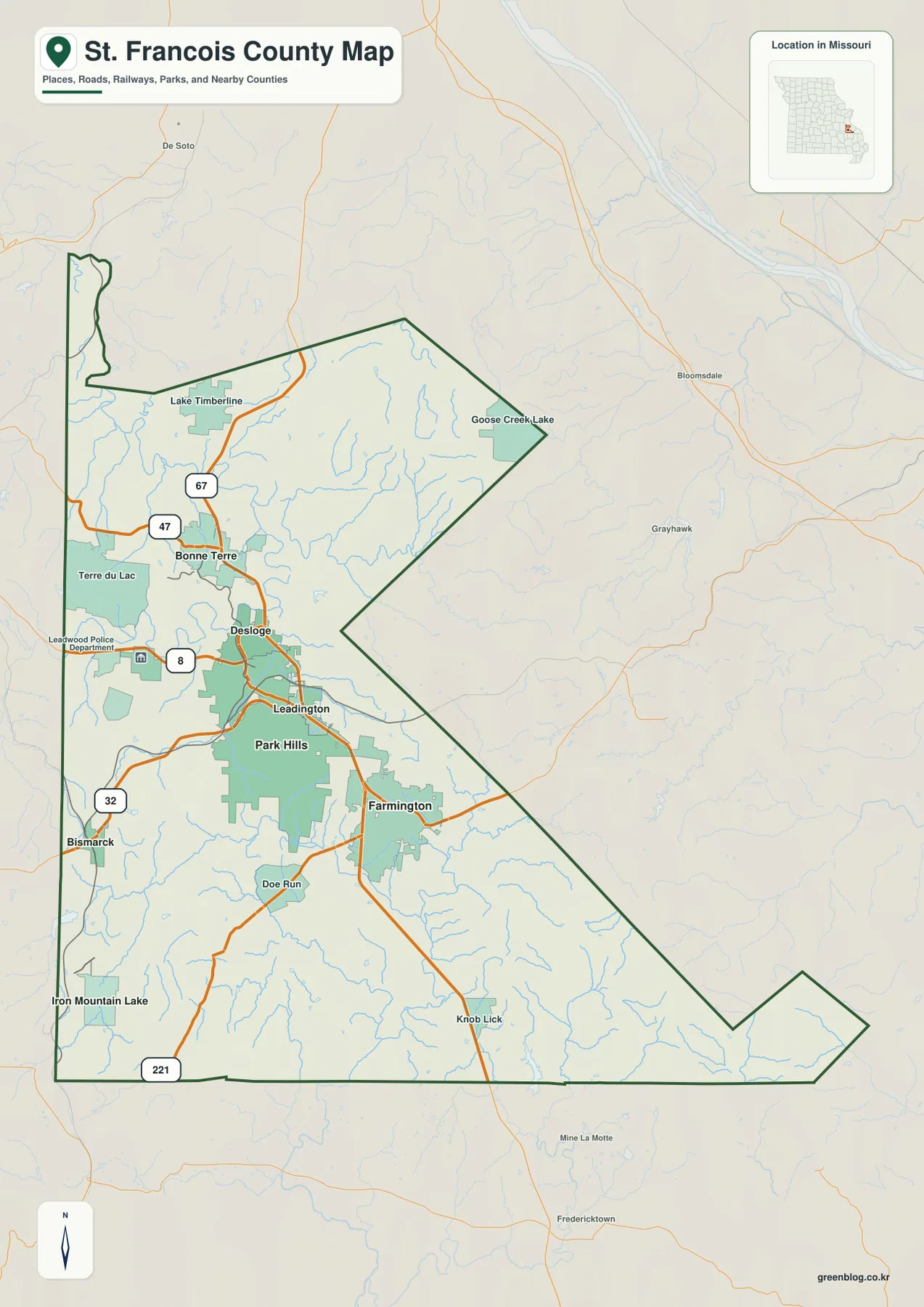
Farmington is the easiest place to begin reading the general map. It has the largest urban footprint in the county and serves as the county seat. The official St. Francois County website places the courthouse and major county offices in Farmington, making the city both a geographic and administrative anchor.
U.S. 67 runs south from Bonne Terre through Desloge and the Park Hills area toward Farmington. Route 47 extends west from the Bonne Terre side, while Route 8 provides an east-west reference around Desloge and Park Hills. The road density is noticeably greater in this urbanized western-central belt than across the more sparsely settled east and south.
Bismarck lies to the southwest near Route 32, and Leadwood sits west of Park Hills. Route 221 reaches into the southern mountain country near Iron Mountain Lake. As the map moves away from Farmington and the U.S. 67 corridor, roads become more widely spaced and more winding because of the stronger local relief.
Lake Timberline and Goose Creek Lake provide useful northern landmarks, while Knob Lick and Doe Run help orient the south and southeast. The county boundary forms a long angled eastern side and a narrow southeastern projection toward Bollinger County. Finding Farmington first, then tracing U.S. 67 north and Route 32 southwest, makes the unusual county shape much easier to organize.
Farmington leads a compact six-city pattern in the western half
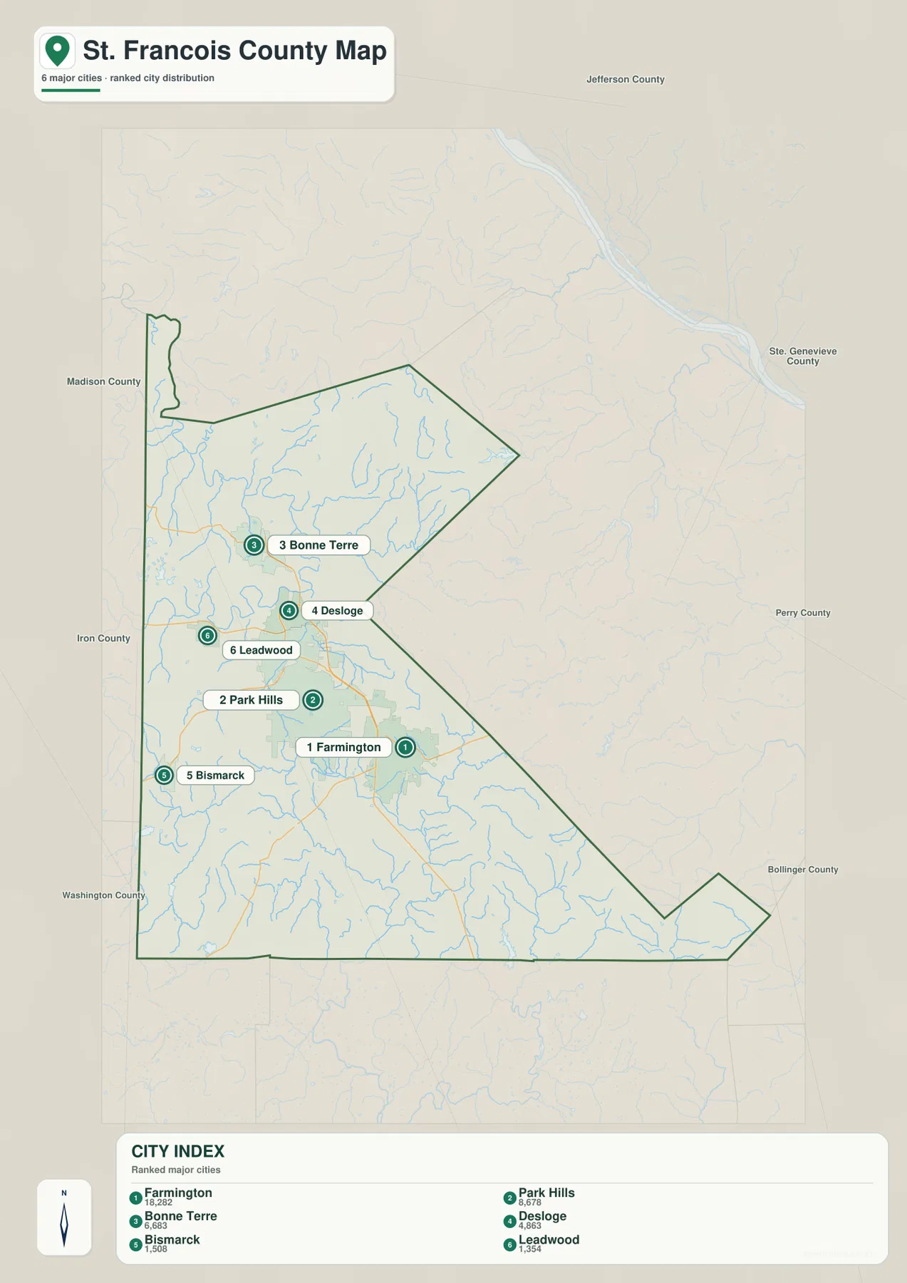
The city map highlights Farmington, Park Hills, Bonne Terre, Desloge, Bismarck, and Leadwood. The map index labels Farmington with 18,282, Park Hills with 8,678, Bonne Terre with 6,683, Desloge with 4,863, Bismarck with 1,508, and Leadwood with 1,354. Farmington clearly leads the ranking, but several other sizable communities sit within a relatively short distance.
Bonne Terre is the northernmost of the six highlighted cities, with Desloge and Park Hills continuing south. Farmington lies southeast of that cluster, while Leadwood sits west of Park Hills and Bismarck farther southwest. The pattern shows that most of the county’s larger settlements are concentrated in the western half rather than spread evenly across the full county.
The official county website describes St. Francois County as part of Missouri’s Lead Belt. The map itself does not depict historical mining boundaries, but the close spacing of Park Hills, Desloge, Leadwood, and other western communities reflects the dense settlement pattern associated with that part of the county.
The general map adds Leadington, Doe Run, Iron Mountain Lake, Goose Creek Lake, and other smaller places that are not included in the six-city index. The ranked view is therefore best for quickly understanding the main urban pattern, while the general map provides the finer settlement and road context.
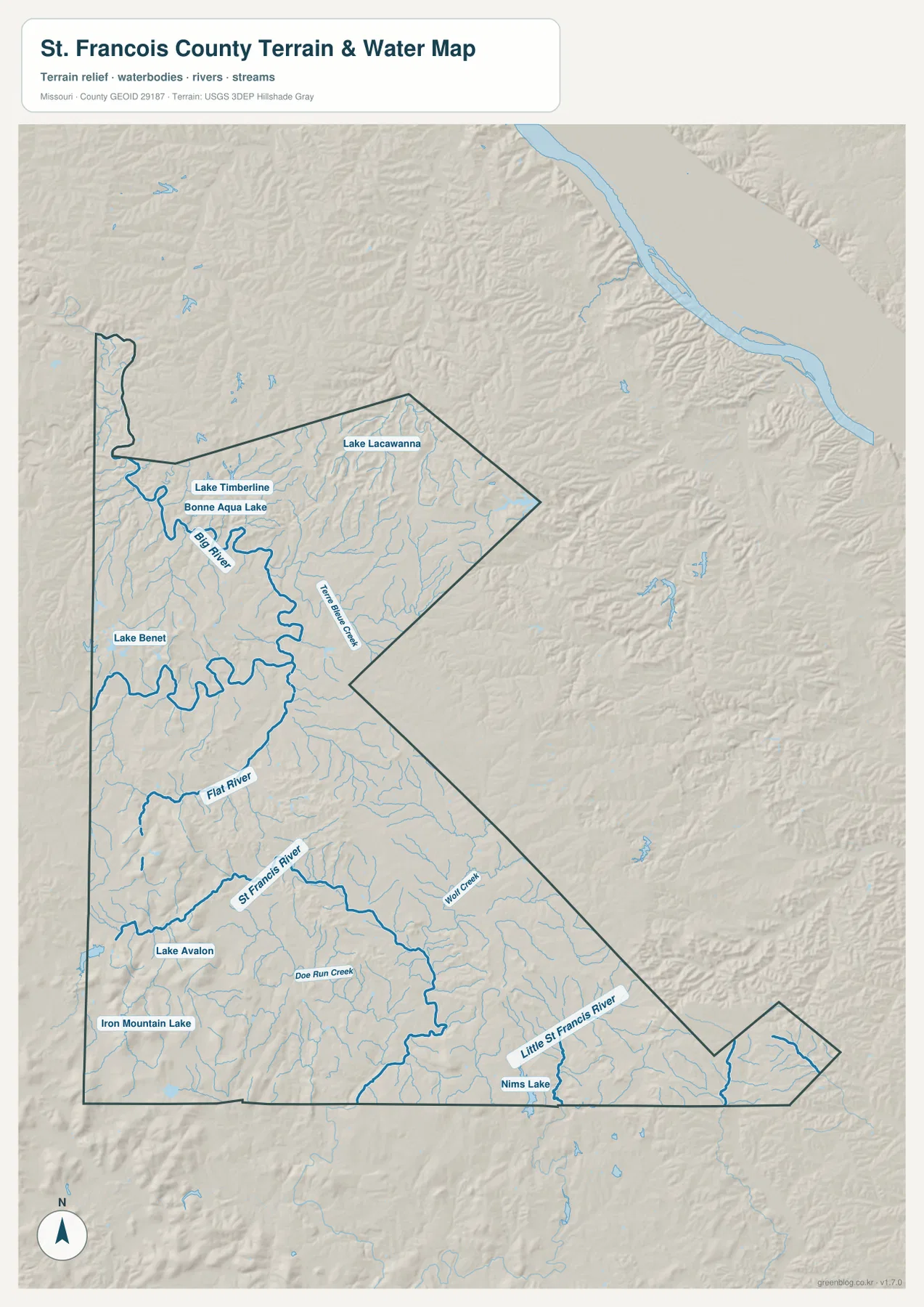
Big River, Flat River, and St. Francois River cut separate valley systems
The Big River is the strongest water reference across the north and central part of the terrain map. It bends through the northwestern interior near Bonne Terre and passes close to Lake Timberline, Bonne Aqua Lake, and Lake Benet. The broad river bends make the northern-central drainage easy to recognize even where city labels are sparse.
Flat River crosses the central county from the west, while Terre Bleue Creek forms a long northeastern valley. Wolf Creek and Doe Run Creek cut through the south-central terrain. Together, these smaller waterways create a dense branching network that divides the uplands into short ridges rather than one smooth plateau.
Farther south, the St. Francois River is a major reference through the higher mountain country, while Little St. Francois River crosses the southeastern side. Lake Avalon, Iron Mountain Lake, and Nims Lake provide additional waterbody landmarks. The contrast between the river valleys and surrounding ridges becomes especially clear when this map is compared with the elevation view.
The terrain-and-water map is intended for geographic reference, not flood determination, depth analysis, navigation, parcel boundaries, or legal water boundaries. River stages and lake conditions change over time, so current flood, recreation, or safety decisions should rely on the appropriate official source.
Elevation ranges from about 172 to 503 meters
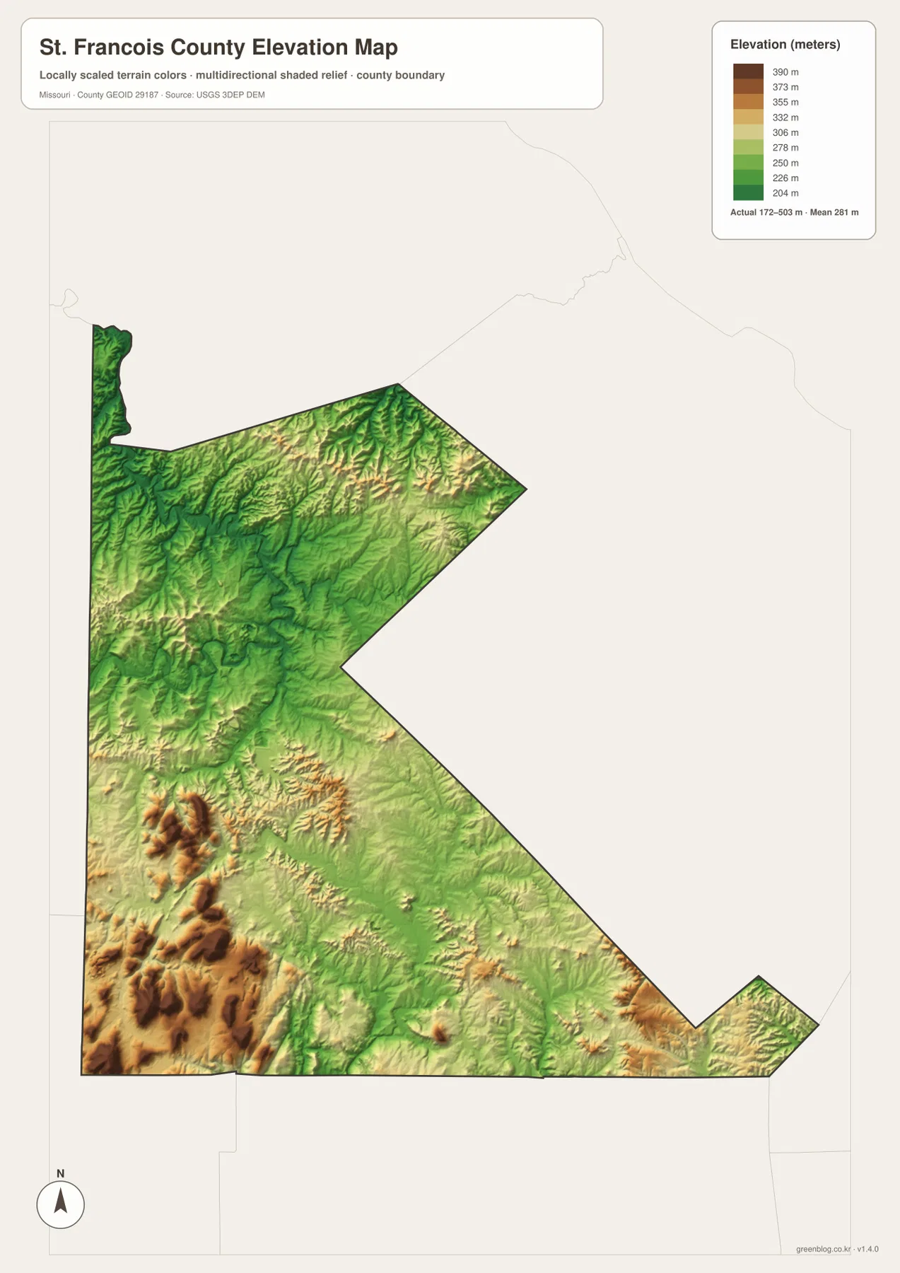
The elevation map reports an actual range of roughly 172 to 503 meters and a mean near 281 meters. The highest dark-brown terrain is concentrated in the southwest, where several ridges and peaks rise toward the 500-meter level. This is a striking elevation contrast compared with the lower central river valleys.
Even within the high southwest, the terrain is deeply dissected. The St. Francois River and numerous short creeks create green lower corridors between sharp ridges, producing repeated elevation changes over short distances. The Bismarck and Iron Mountain Lake side shows this rugged relief especially clearly.
Central and northern St. Francois County is generally lower than the southwest but is still rolling. Big River, Flat River, and Terre Bleue Creek form lower green corridors through the uplands, while tan and brown ridges remain between them. Smaller high areas also appear in the northeast and southeast, so elevation does not simply decline in one direction.
This county-scale elevation surface is useful for broad relief comparison, not for engineering, construction, drainage design, parcel-level elevation decisions, or survey-grade measurement. Site-specific work requires more detailed official elevation data or field surveying.
Compare the urban corridor with river valleys and high southwestern terrain
Start with Farmington and U.S. 67 when roads and settlement locations matter most. Park Hills, Desloge, and Bonne Terre line up to the north, while Bismarck and Leadwood identify the hillier western and southwestern side. The city map is faster when only the relative scale and distribution of the six highlighted communities are needed.
For waterways, begin with Big River and Flat River, then compare St. Francois River and Little St. Francois River in the south. Lake Timberline, Bonne Aqua Lake, Lake Avalon, and Nims Lake provide additional geographic anchors. Moving to the elevation map afterward shows how these rivers occupy lower corridors between higher ridges.
St. Francois County combines an unusually concentrated urban pattern with strongly varied relief. The Farmington–Park Hills corridor is relatively developed, while the southwest quickly rises into much rougher mountain terrain. The road, water, and elevation maps together make that transition easy to understand.
The downloadable JPG originals contain more pixels than the WebP previews embedded on the page, making them better for enlargement, A3 printing, classroom handouts, reports, and personal reference. They remain general-purpose maps, however. Legal boundaries, property ownership, live road restrictions, current water conditions, and precise site elevations should always be checked against the appropriate current official source.
Frequently Asked Questions
Which roads are the easiest references in St. Francois County?
U.S. 67 is the clearest starting point because it links Bonne Terre, Desloge, Park Hills, and Farmington. Routes 47, 8, 32, and 221 provide useful references for the western and southwestern parts of the county.
How much elevation change is shown across St. Francois County?
The elevation map shows an actual range of about 172 to 503 meters with a mean near 281 meters. Southwestern ridges are highest, while the Big River, Flat River, and St. Francois River valleys occupy much lower ground.
Which waterways are the best starting points on the terrain map?
Start with Big River and Flat River in the north and center, then compare St. Francois River in the south. Terre Bleue Creek, Little St. Francois River, Lake Timberline, and Lake Avalon provide additional landmarks in different parts of the county.
Map File Information
The download ZIP contains high-resolution JPG versions of the St. Francois County general map, city map, terrain-and-water map, and elevation map.
- File Type: JPG
Related Maps
Sources and References
Boundary and road reference data are supported by U.S. Census Bureau TIGER/Line, water features by USGS National Hydrography, and elevation data by the USGS 3D Elevation Program. County government and courthouse information in Farmington is available from the official St. Francois County website.
Green Map creates custom-edited map images using open geographic data sources such as geoBoundaries, Natural Earth, OpenStreetMap, and government open data. These maps are edited visual materials, not raw data files, and are provided for education, documents, presentations, and graphic reference.