Audrain County lies in central Missouri, with Mexico serving as the county seat and the clearest road reference on the supplied maps. Route 15 runs north–south through Mexico, Route 22 reaches the city from the west, and U.S. 54 continues east toward the Laddonia side of the county. Vandalia and Farber occupy the northeast, while Martinsburg and Benton City lie farther southeast. The general, city, water, and elevation maps on this page are also available as four high-resolution JPG originals in the downloadable ZIP below.
The landscape is more varied than the road map first suggests. Higher rolling ground occupies much of the west and southwest, while the South Fork Salt River cuts a lower north–south valley through the middle. Littleby Creek and the West Fork Cuivre River drain the eastern side, where the terrain is generally lower. The elevation legend reports an actual range of about 196 to 290 meters and a mean near 243 meters.
Table of Contents
Mexico sits where Route 15, Route 22, and U.S. 54 meet
Mexico lies slightly west of the geographic center of Audrain County and is the easiest place to start on the general map. Route 15 approaches from the north and continues south, Route 22 enters from the Centralia side, and U.S. 54 leaves Mexico toward Laddonia and the eastern county. The concentration of roads around the city matches its role as the county seat and largest community described on the official Audrain County website.
East of Mexico, Rush Hill and Benton City provide intermediate points before the Route 19 corridor. Route 19 runs north–south near Laddonia and Martinsburg, giving the eastern half a second strong road reference. From Laddonia, roads continue toward Farber and Vandalia in the northeast. The spacing between these places makes it clear that Audrain County is not one continuous urban strip; small communities are separated by broad rural areas and drainage valleys.
The western extension of the county reaches toward the Centralia side, and Route 151 is visible in that broader area. The county outline itself is irregular, with a large western projection and a smaller eastern section around Vandalia. Reading Mexico first, then Route 19 and Vandalia, provides a much simpler framework than trying to follow every local road at once.
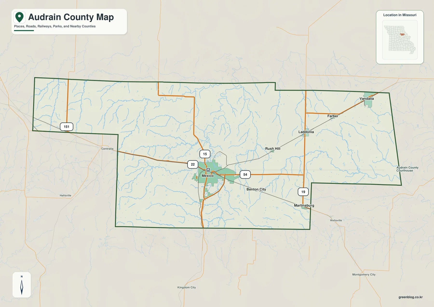
Martinsburg sits near Route 19 in the southeast, while Benton City lies closer to U.S. 54 between Mexico and the eastern county. Wellsville and Montgomery City are shown beyond the southeastern boundary, and Centralia lies outside the western side. These surrounding places help position Audrain County within central Missouri without confusing them with communities inside the county.
Audrain County’s official website describes a county of roughly 26,000 residents living in eight municipalities and identifies Mexico as both the largest community and the county seat. The map reflects that concentration: Mexico has by far the largest built-up area, while the other towns are much smaller and more widely spaced. For live closures or construction, current transportation sources should be used in addition to this static road reference.
Mexico and Vandalia dominate the six-city comparison
The city map ranks six highlighted communities. Its CITY INDEX lists Mexico at 11,477, Vandalia at 3,140, Laddonia at 533, Martinsburg at 522, Farber at 272, and Vandiver at 127. These are the reference values printed on the supplied map and are useful for comparing the places shown there. The latest official population counts should be checked in current Census or county records when needed.
Mexico is the clear first-ranked city and occupies the central-western part of the county. Vandalia is the second-largest highlighted community and sits far to the northeast, creating a strong two-center contrast. Laddonia and Farber are also part of the northeastern group, while Martinsburg lies southeast and Vandiver is close to Mexico on the east side of the city.
The official Audrain County communities directory lists Mexico, Vandalia, Laddonia, Farber, Martinsburg, Benton City, Rush Hill, and Vandiver Village. The city map intentionally simplifies that fuller list to six ranked points. Comparing the two map types therefore helps separate settlement size from the complete set of named communities.
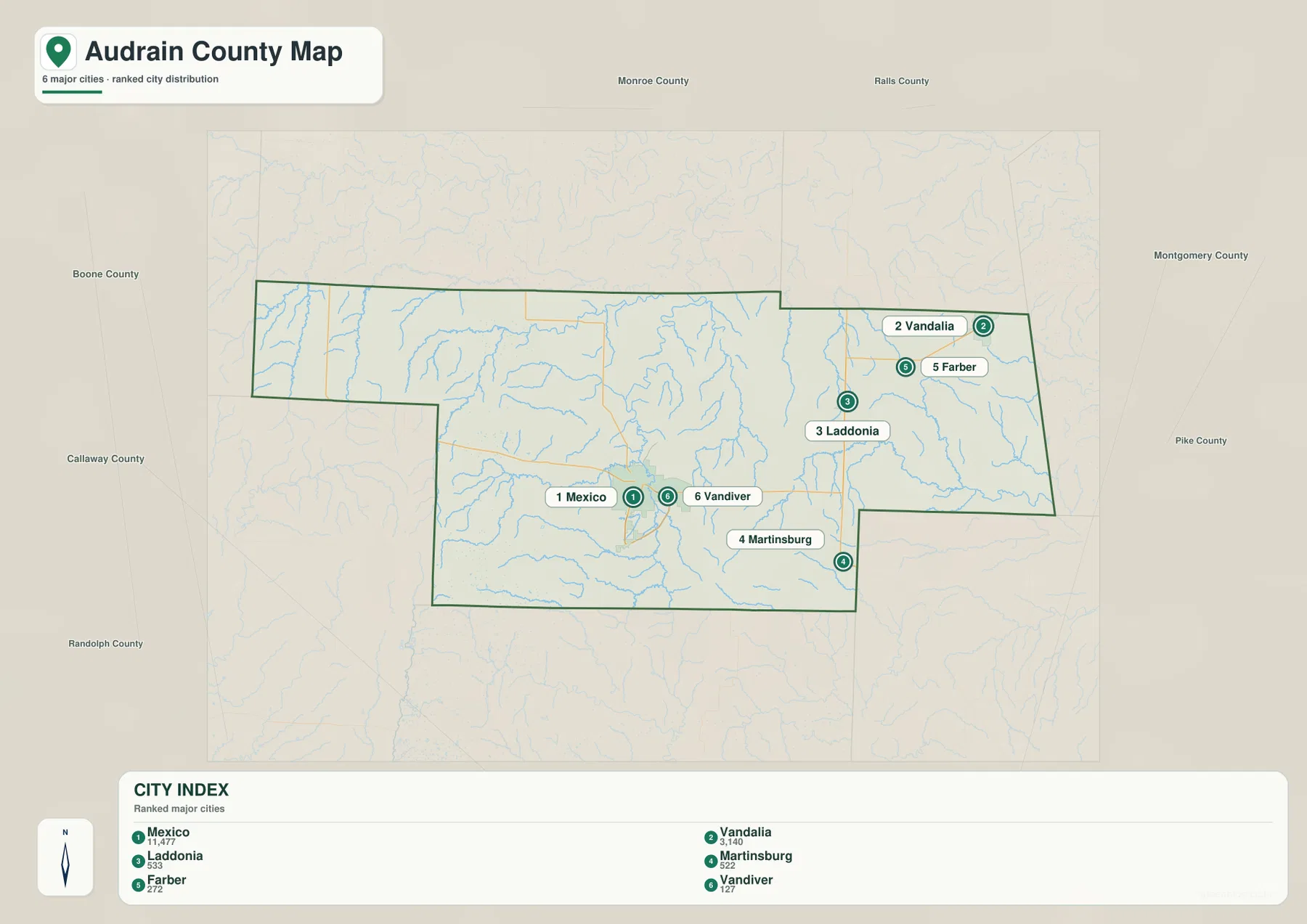
The city view does not show driving distance or travel time. It is best for comparing relative location and scale. To understand how Mexico connects with Vandalia, Laddonia, or Martinsburg, return to the general map and follow U.S. 54, Route 19, and the local roads that cross the county.
The large visual gap between Mexico and Vandalia is also informative. Audrain County contains extensive rural land between its communities, and the roads cross many small stream valleys along the way. That dispersed settlement pattern is one of the main reasons the water and elevation views add useful context to the simpler city ranking.
South Fork Salt River separates the central county from the Cuivre drainage
The South Fork Salt River is the strongest named water feature near the center of the county. It enters from the north, bends through a broad valley east of Mexico, and continues south past the Timber Lake area. Davis Creek and Skull Lick Creek join from the west, while Youngs Creek occupies a separate valley farther northwest. These streams divide the rolling terrain into many smaller ridges.
East of the South Fork Salt River, Littleby Creek runs south through the middle-eastern part of the county. Farther east, the West Fork Cuivre River becomes the main drainage line, with Hickory Creek and numerous smaller tributaries entering around the Vandalia side. The separation between the Salt and Cuivre systems is one of the clearest geographic differences within Audrain County.
The western and southwestern sections also contain many smaller waterways. Beaverdam Creek crosses the southwest, Davis Creek passes near Lakeview Lake, and Long Branch is labeled in the far western extension. Larrabee Lake, Lakeview Lake, and Timber Lake provide useful water landmarks even though no single large lake dominates the county.
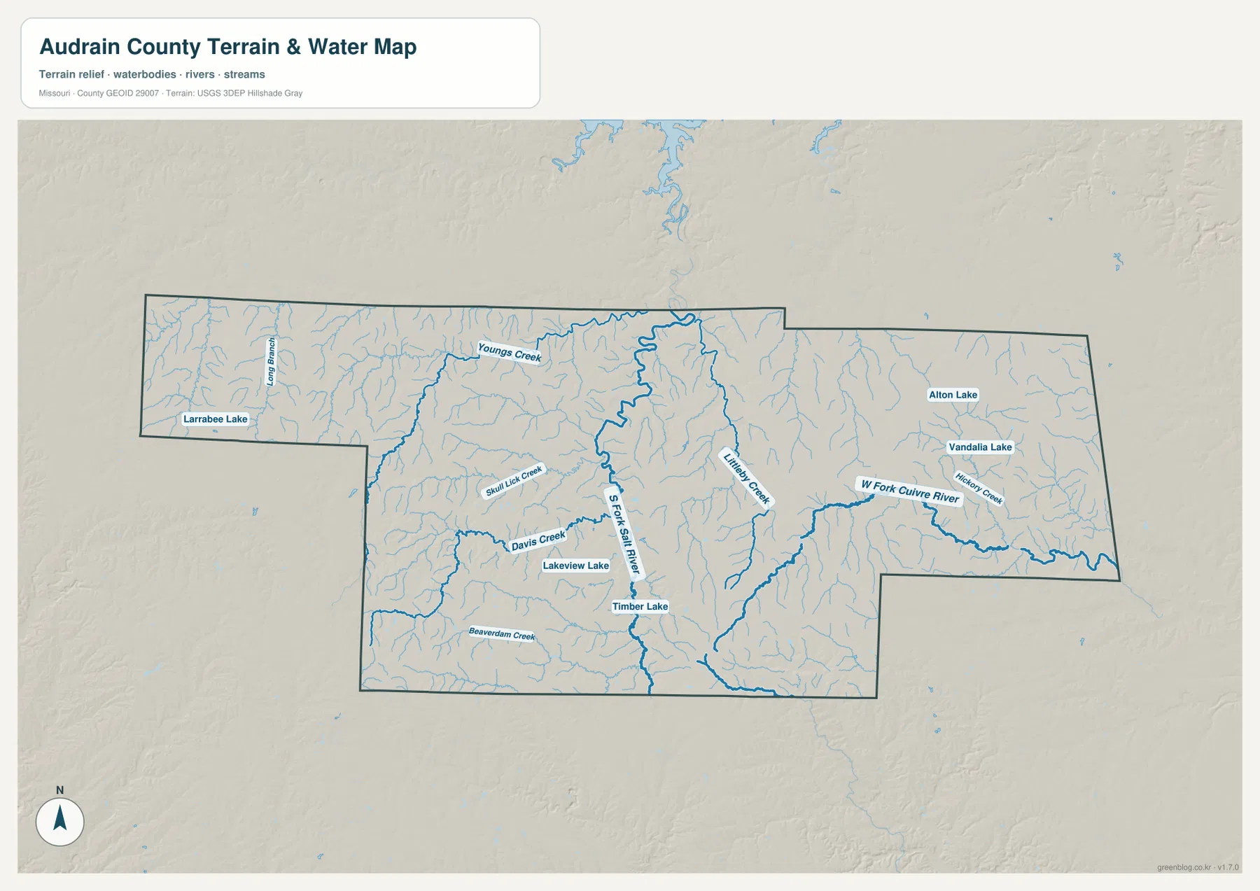
Alton Lake and Vandalia Lake appear in the northeast close to the Vandalia side of the map. Hickory Creek and the West Fork Cuivre River help tie those lakes to the broader eastern drainage pattern. Starting at Vandalia and tracing the Cuivre system westward is an easy way to see why the northeastern terrain is lower and more stream-cut than parts of the western county.
Missouri Department of Conservation places Robert M. White II Conservation Area about 11 miles north of Mexico, partly in Audrain County, with numerous ponds and a 15-acre fishing lake. William Lowe Conservation Area lies on the southern edge of Mexico, where Teal Creek flows toward Teal Lake. These official sites provide local detail, while the county water map is intended for the broader relationship among rivers, creeks, and towns.
This water image is a geographic reference rather than a flood-risk, depth, water-quality, legal-boundary, or navigation product. Those questions require current specialized sources. For general map reading, trace the South Fork Salt River first, then compare Littleby Creek and the West Fork Cuivre River to see how the county is divided into separate drainage areas.
Elevation falls from western and southwestern uplands toward eastern valleys
The elevation legend reports an actual range of about 196 to 290 meters with a mean near 243 meters. Brown and orange terrain is most extensive in the west and southwest, especially in the western projection and south of Mexico. The eastern half contains much more green, indicating lower elevations around the major stream valleys.
A pronounced low corridor follows the South Fork Salt River north and east of Mexico. The river valley appears as a dark-green band with yellow and tan ridges rising on both sides. Mexico itself occupies intermediate ground between the higher southwest and the lower river country to the east and northeast.
The West Fork Cuivre River and its tributaries create additional low corridors near Vandalia, Farber, and the eastern county. That part of the map is generally lower than the southwest, though small ridges still separate the streams. Martinsburg and the southeast also sit among many branching valleys tied to the Cuivre drainage.
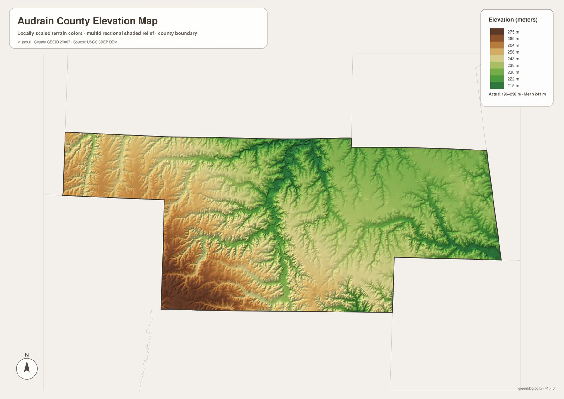
The west is not one smooth plateau. Long Branch, Youngs Creek, Davis Creek, and other tributaries cut lower green paths through the higher ground. The county is therefore best understood as a broad west-to-east decrease in elevation overlaid by many smaller valleys, rather than a single uninterrupted slope.
This elevation surface is generalized for county-scale comparison. It should not be used to establish the exact height of a parcel, road grade, drainage structure, or construction site. Those uses require source elevation data and field verification. For ordinary map reading, the image is especially helpful for comparing Mexico’s western uplands with the lower Salt and Cuivre river systems.
A simple sequence for reading all four Audrain County views
Start with Mexico and identify Route 15, Route 22, and U.S. 54. Follow U.S. 54 east to Laddonia and Route 19, then add Farber and Vandalia farther northeast. Benton City and Martinsburg complete the southeastern side, while Vandiver provides a close reference just east of Mexico. Once those places are fixed, the irregular county outline becomes much easier to follow.
Next, use the water map to locate the South Fork Salt River. Compare Davis Creek and Skull Lick Creek on the west with Littleby Creek and the West Fork Cuivre River on the east. On the elevation map, those same waterways become low green corridors between higher tan and brown ground, showing how strongly the road and settlement pattern is tied to the terrain.
Choose the general map for roads, towns, and county boundaries. Use the city map to compare the six highlighted communities, the water map for rivers, creeks, and lakes, and the elevation map for the 196–290 meter relief. Selecting the view that matches the task keeps the information clear for printing, classwork, presentations, or personal reference.
Frequently Asked Questions
Where is Mexico within Audrain County?
Mexico lies slightly west of the county center and is the main road hub, with Route 15, Route 22, and U.S. 54 meeting in or near the city. The official county website identifies Mexico as the county seat and largest community. Laddonia and Vandalia lie to the east and northeast, while Martinsburg is farther southeast.
Which city is second-largest on the supplied city map?
Vandalia is second in the CITY INDEX at 3,140, behind Mexico at 11,477. Laddonia, Martinsburg, Farber, and Vandiver are the other highlighted communities. These are map reference values rather than a substitute for the latest official Census figures.
Where is the lowest terrain in Audrain County?
The lowest terrain follows major central and eastern stream valleys, especially the South Fork Salt River and the West Fork Cuivre River system. The legend reports an actual elevation range of about 196 to 290 meters and a mean near 243 meters. The west and southwest contain more of the higher tan and brown terrain.
Map File Information
The ZIP contains the high-resolution JPG originals of the Audrain County general map, city map, water map, and elevation map shown on this page.
- Included Files: 4 high-resolution JPG maps
Related Maps
Sources and references
- Audrain County, Missouri official website — county overview, Mexico county-seat information, and local resources
- Audrain County Communities — official community directory for Mexico, Vandalia, Laddonia, Farber, Martinsburg and others
- Missouri Department of Conservation — Robert M. White II Conservation Area — conservation land and lake information north of Mexico
- Missouri Department of Conservation — William Lowe Conservation Area — Teal Creek and Teal Lake area on the south edge of Mexico
- U.S. Census Bureau TIGER/Line Shapefiles — county boundaries and geographic reference data
- USGS 3D Elevation Program — elevation and terrain reference data
Green Map creates custom-edited map images using open geographic data sources such as geoBoundaries, Natural Earth, OpenStreetMap, and government open data. These maps are edited visual materials, not raw data files, and are provided for education, documents, presentations, and graphic reference.