Barry County occupies the southwest corner of Missouri, where the urban pattern around Monett and Cassville gives way to deeply cut Ozark valleys and the irregular shoreline of Table Rock Lake. This Barry County Missouri Map set is designed to make those contrasts easy to follow. The county map emphasizes boundaries, towns, roads, and nearby lake communities; the city map isolates the main population centers; the water map highlights named streams and the White River system; and the elevation map shows how higher uplands break into lower valleys toward the east and southeast. High-resolution JPG versions of the same maps are available in the download box below.
The most useful way to approach Barry County is to start with its two strongest reference points. Monett sits near the northern edge of the county along U.S. 60, while Cassville lies farther south near the middle of the county’s road network. Purdy and Butterfield appear between them, and Exeter, Washburn, and Seligman form a loose chain toward the west and southwest. In the southeast, the map changes character around Shell Knob, Golden, Emerald Beach, Arrow Point, and Chain-O-Lakes, where roads and settlements follow the winding arms of Table Rock Lake rather than a simple north-south pattern.
Table of Contents
Finding Barry County through Cassville and Monett
Barry County is in southwestern Missouri and reaches the Arkansas state line along its southern side. On the county map, Monett is easy to locate at the north, while Cassville provides a practical center point for reading the rest of the county. The Barry County government site identifies Cassville as the location of the courthouse and county offices, and its historical summary notes that the county seat was moved there in 1845. That makes Cassville a useful administrative reference, but the map also shows that Monett is a separate and prominent urban center near the northern boundary.
U.S. Census Bureau QuickFacts reports a 2020 population of 34,534 for Barry County. The geographic pattern behind that number is spread across several communities rather than concentrated in one large city. Monett anchors the northern part of the map, Cassville serves as a central-southern reference, and smaller communities extend along the road system between and beyond them. In the lake country to the southeast, settlement names hug the shoreline and nearby valleys, making that part of Barry County look much more fragmented than the broad northern and western interior.
U.S. 60 in the north and the roads that converge on Cassville
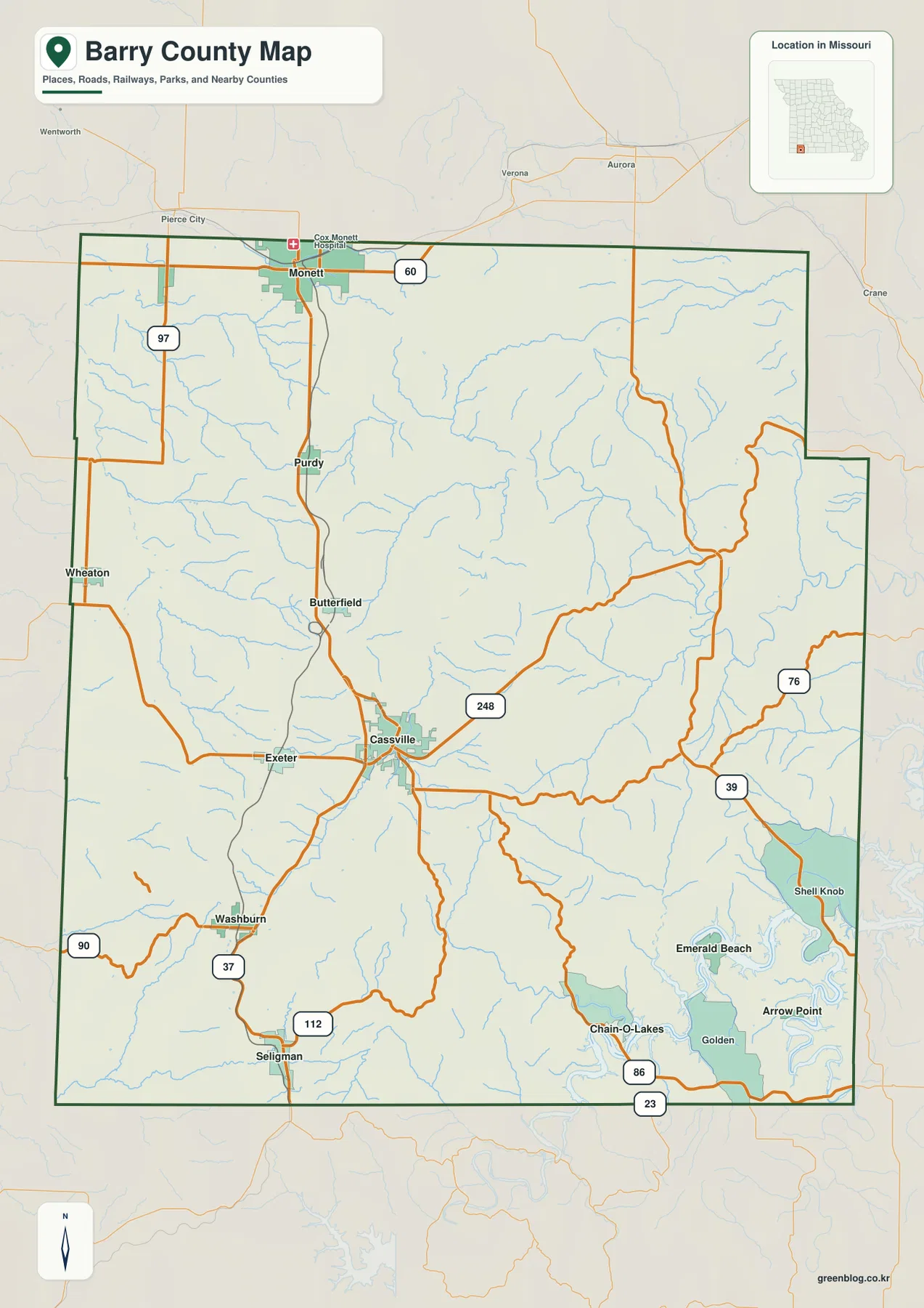
The road pattern is easiest to understand by separating the north from the interior. U.S. 60 runs east-west through the Monett area near the top of the county. From Monett, a major north-south route continues through Purdy and Butterfield toward Cassville, creating a clear sequence of towns through the western half of Barry County. Missouri Route 37 is labeled farther south near Washburn and continues toward Seligman, while Routes 90 and 112 provide additional east-west connections in the southwest. Route 248 leaves the Cassville area toward the east and helps tie the county center to the hillier interior.
Roads in the eastern and southeastern part of the county look different. Routes 76, 39, and 86 bend through more dissected terrain and approach the Table Rock Lake region, where coves, ridges, and stream valleys interrupt the straighter road geometry seen farther north. This is one reason the county map is more useful than a simple list of highways: it shows how road direction changes as the landscape changes. For actual driving, however, this map should be treated as a geographic reference rather than a live navigation product. Current road closures, traffic conditions, construction, and turn-by-turn routing should be checked with an up-to-date navigation service.
A city pattern divided between the north, center, and southwest
The city map ranks six major communities and makes their relative positions much easier to compare. Monett is marked first, Cassville second, followed by Purdy, Seligman, Exeter, and Washburn. That ranking is an index for the cities included in this particular map, not a claim that these are the only communities in Barry County. The broader county map includes additional places such as Butterfield, Shell Knob, Golden, Emerald Beach, Arrow Point, and Chain-O-Lakes, which are useful when the goal is to understand local geography rather than only the six-city index.
The six indexed cities form a clear spatial sequence. Monett is close to the northern boundary, Purdy lies south of it, and Cassville sits farther down the county where several roads meet. Exeter is west of Cassville, while Washburn and Seligman occupy the southwest. This arrangement makes the city map especially helpful for classroom work, regional orientation, or any project that needs a clean reference to the main named communities without the full visual detail of the county map. Pairing it with the general map restores the highway numbers, smaller settlements, and lake communities that are intentionally reduced in the city-focused version.
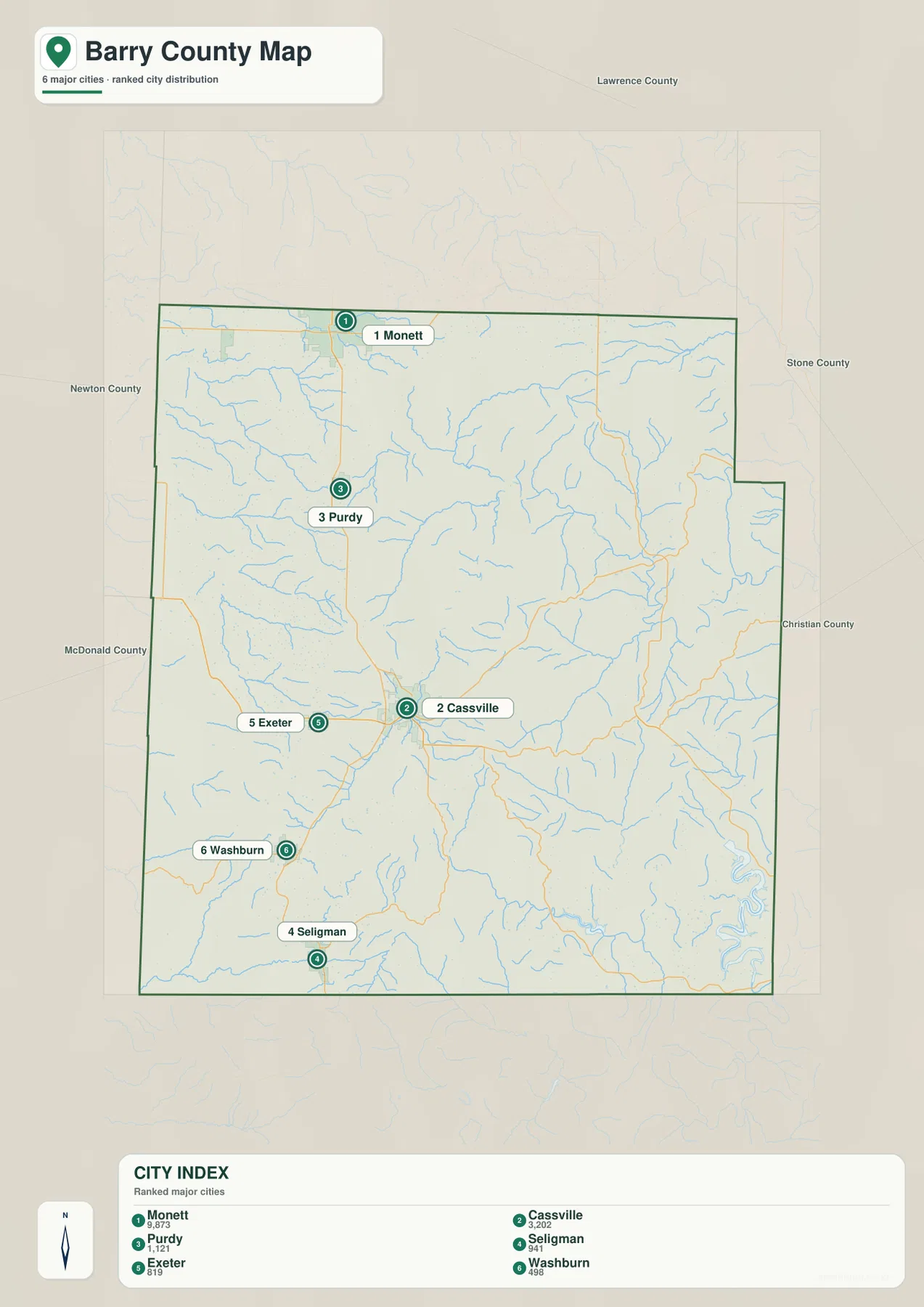
Table Rock Lake, the White River system, and the county’s creek valleys
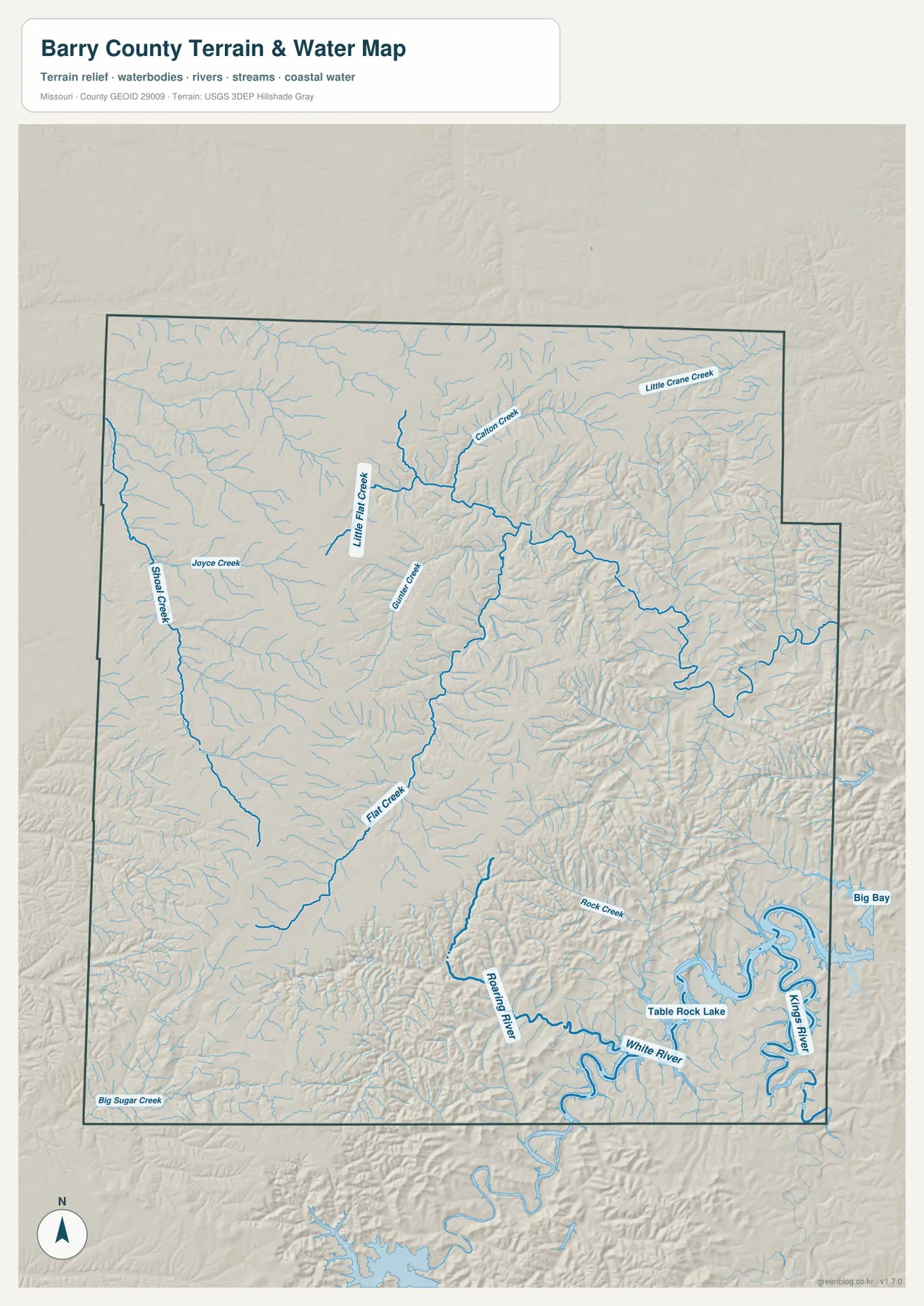
The water map gives Barry County a very different visual structure. Table Rock Lake dominates the southeast, with a shoreline that branches repeatedly into narrow coves and valleys. The labels for the White River and Kings River connect that lake area to a much larger river system, while the U.S. Army Corps of Engineers describes Table Rock Lake as a reservoir on the White River extending through southwestern Missouri and into Arkansas. On the county map, communities such as Shell Knob, Golden, Emerald Beach, Arrow Point, and Chain-O-Lakes cluster around this broken shoreline, so the water map helps explain why settlement and road patterns are more irregular here.
A second group of waterways crosses the interior and west. Flat Creek is one of the strongest named channels on the map, with Little Flat Creek and Gunter Creek visible nearby. Shoal Creek and Joyce Creek appear in the western half, while Little Crane Creek is labeled in the northeast. Roaring River and Rock Creek stand out farther south, and Big Sugar Creek is shown near the southwest edge. These streams do more than provide names: their valleys cut into the uplands and create the branching low areas that become even clearer on the elevation map.
The water layer should not be interpreted as a flood map, parcel map, legal shoreline survey, or boating chart. It is best used to understand the relative positions of rivers, creeks, lake arms, and terrain. That distinction matters around Table Rock Lake, where the shoreline is highly detailed and where federal land and lake-management boundaries may differ from the simplified county-scale geography shown here. For boundary or shoreline decisions, users should consult the appropriate official agency records rather than the reference map alone.
Elevation separates broad uplands from deeply cut eastern valleys
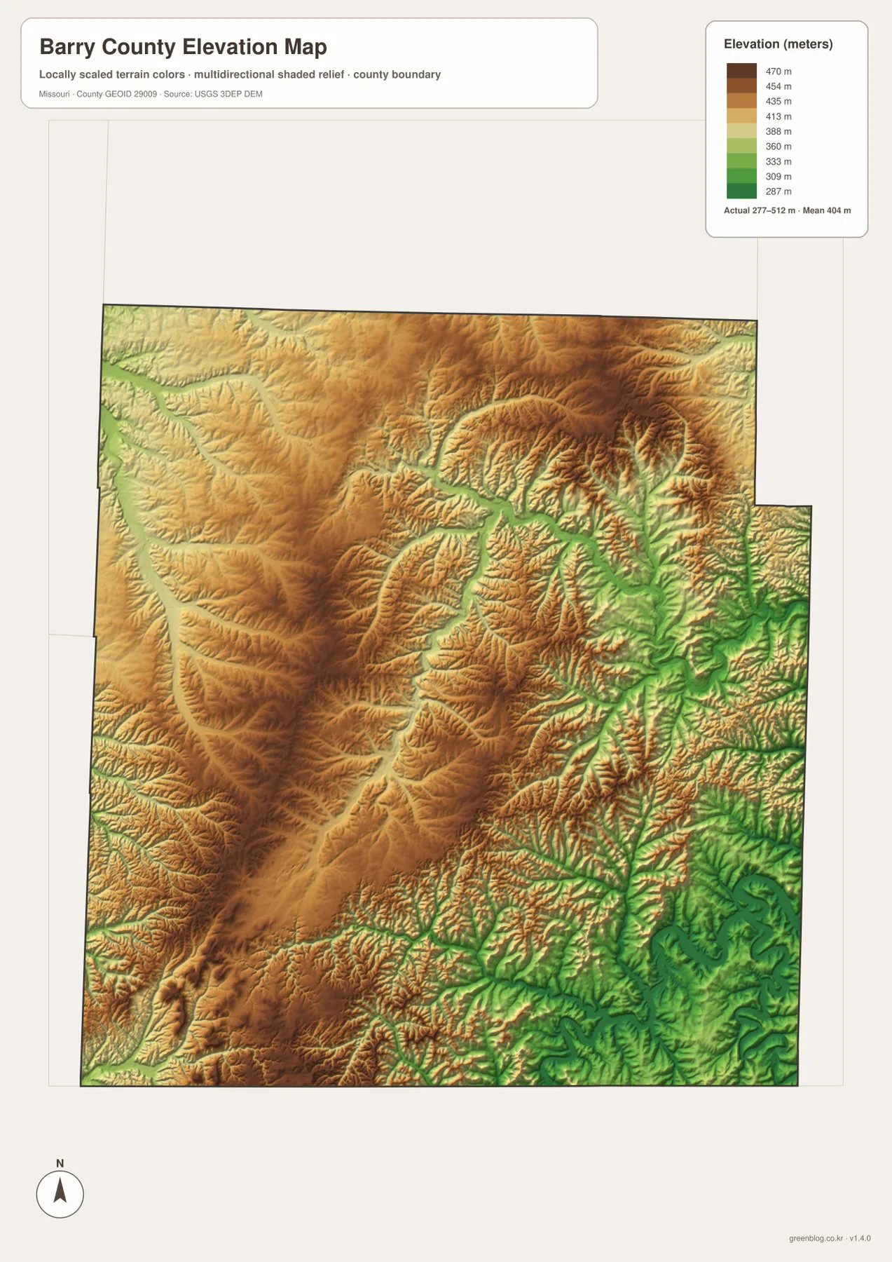
The elevation map shows why eastern and southeastern Barry County look so intricate on the road and water maps. Its legend gives an actual mapped elevation range of roughly 277 to 512 meters, with a mean near 404 meters. Higher ground appears in brown and orange across much of the western, central, and northern interior. Lower terrain, shown in green, becomes more extensive in the east and southeast, where stream valleys divide the hills into narrow ridges and branching hollows. The Table Rock Lake area occupies some of the lowest and most deeply cut parts of the mapped surface.
This relief also helps explain the contrast between the Monett area and the lake country. Around the north, broad upland surfaces look relatively continuous, while farther east the terrain breaks into a close network of ridges and valleys. East and southeast of Cassville, the stronger relief corresponds with the curving roads and dense drainage lines seen on the other maps. The elevation layer is therefore most useful when used in combination with the road and water maps rather than as an isolated color image.
The elevation surface is a county-scale reference, not survey-grade or engineering-grade measurement. It can show that one part of Barry County is generally higher or lower than another and can help explain broad terrain relationships, but it should not be used to determine a property elevation, building pad height, exact slope, or legal boundary. Those tasks require purpose-built elevation data, professional surveying, or official project records.
Choosing the map that fits the question
For a quick orientation to Barry County, the general county map is the best starting point because it combines the boundary, principal road numbers, major towns, smaller named communities, streams, and the Table Rock Lake edge. If the task is to compare the locations of the main towns without the full road network, the city map is cleaner. It makes the separation between Monett, Cassville, Purdy, Seligman, Exeter, and Washburn immediately visible, which is helpful when a presentation or worksheet needs a simple location reference.
The water and elevation maps answer a different set of questions. Use the water map when the relationship between Flat Creek, Roaring River, White River, Table Rock Lake, and smaller tributaries matters. Use the elevation map when the goal is to understand why the southeast has so many narrow valleys and why roads there curve more frequently. Looking at the two together is especially effective: the major watercourses tend to occupy the lower green valleys, while the surrounding higher ridges appear in warmer colors on the terrain surface.
For printing, offline reference, or inserting a map into a lesson or report, the downloadable JPG files preserve more detail than the smaller WebP previews used in the article. Each file covers the same county but emphasizes a different layer of information, so selecting one map for one purpose is usually clearer than trying to force every feature into a single image. The four-map archive contains the county, city, water, and elevation versions at 2572 by 3638 pixels.
What makes Barry County especially useful to compare across maps
Barry County is a good example of why a single county can need more than one geographic view. The north is organized around Monett and U.S. 60, the interior is tied together by roads through Purdy, Butterfield, and Cassville, and the southwest extends through Exeter, Washburn, and Seligman. The southeast behaves differently because Table Rock Lake, the White River system, and deeply cut Ozark valleys create a much more irregular pattern of roads and settlements. The same places therefore look different depending on whether the map emphasizes transportation, city distribution, water, or elevation.
The county’s official website adds historical context by noting that Barry County was created in 1835 and that the county seat was moved to Cassville in 1845. That background helps explain why Cassville remains an important administrative reference even though Monett appears as the largest indexed city on the city map. Meanwhile, the U.S. Army Corps of Engineers’ information on Table Rock Lake connects the southeast corner of the county to a reservoir and recreation landscape that extends far beyond the county boundary. These two anchors—Cassville in the interior and Table Rock Lake in the southeast—make the map set useful for understanding both local organization and broader Ozark geography.
Frequently Asked Questions
Where are Cassville and Monett on the Barry County maps?
Monett is near the northern edge of Barry County along U.S. 60. Cassville is farther south, slightly below the county’s center, where several routes converge. Purdy and Butterfield lie between the two, so the general map gives a clear north-to-south sequence from Monett through the interior toward Cassville.
Which map is best for understanding Table Rock Lake in Barry County?
The water map is the clearest choice for the lake itself because it emphasizes the branching shoreline, White River system, Kings River, and nearby streams. The elevation map is a useful companion because it shows the lower valleys and surrounding ridges that shape the lake country. The general county map is best when you also need nearby communities such as Shell Knob, Golden, Emerald Beach, and Arrow Point.
Can the elevation map be used for surveying or construction design?
No. The elevation map is intended for county-scale geographic reference and comparison. It can show broad differences between higher uplands and lower valleys, but it does not establish exact property elevations, boundaries, engineering grades, or construction measurements. Those uses require official project data or a professional survey.
Map File Information
The archive contains the Barry County general, city, water, and elevation maps as original high-resolution JPG files.
- Included Files: County map, city map, water map, elevation map
- File Type: JPG
Related Maps
Sources and References
- Barry County, Missouri Government – county offices, community information, and local history
- U.S. Census Bureau QuickFacts: Barry County, Missouri – population and county statistics
- U.S. Census Bureau TIGER/Line Shapefiles – geographic boundary reference
- USGS National Hydrography – rivers, streams, and water-feature reference
- USGS 3D Elevation Program – elevation-data reference
- U.S. Army Corps of Engineers: Table Rock Lake – official information on the lake and White River reservoir system
Green Map creates custom-edited map images using open geographic data sources such as geoBoundaries, Natural Earth, OpenStreetMap, and government open data. These maps are edited visual materials, not raw data files, and are provided for education, documents, presentations, and graphic reference.