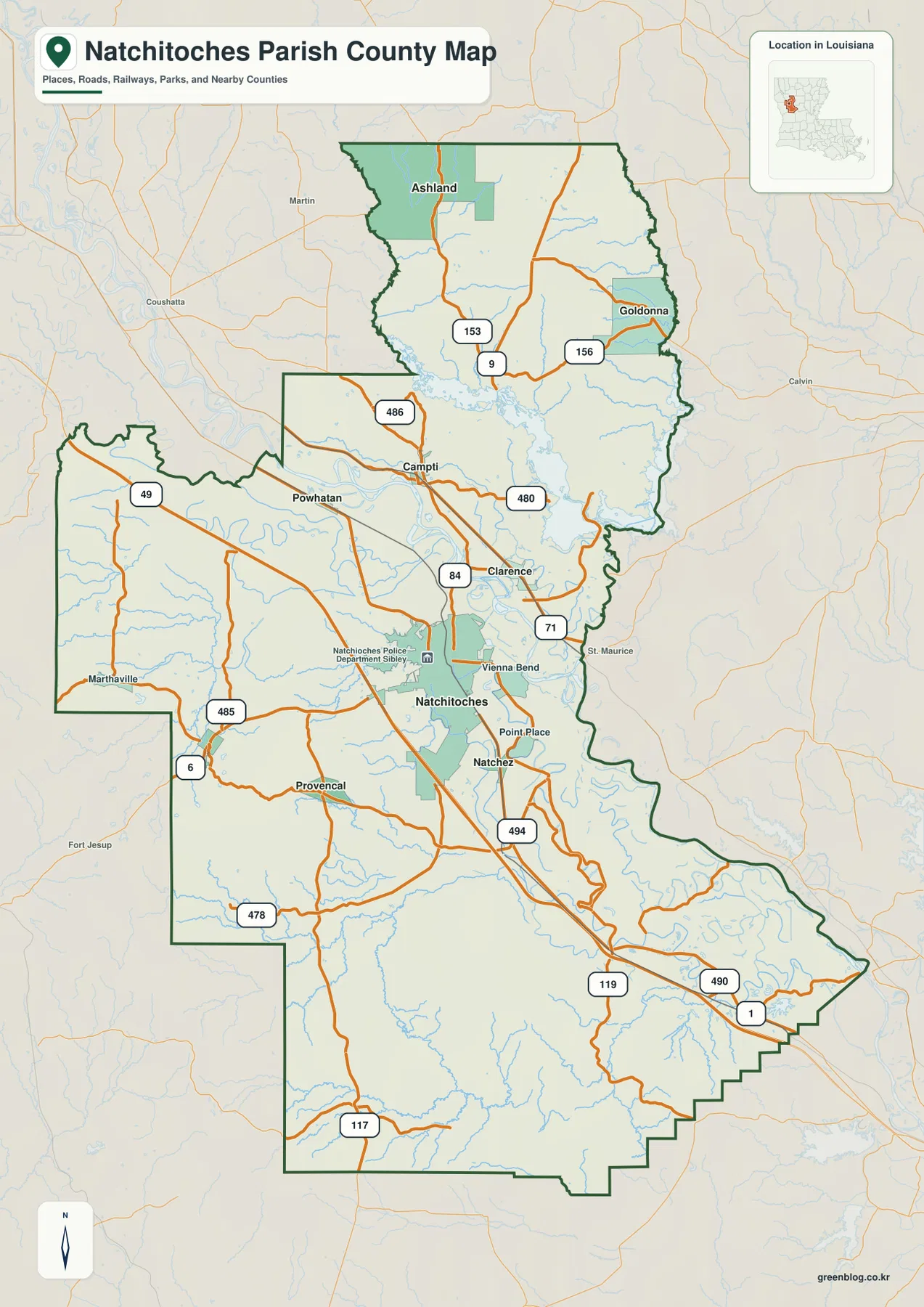
Natchitoches Parish stretches a long distance from the Black Lake country in the north to the Cane River and Kisatchie Bayou drainage in the south. The city of Natchitoches provides the central reference point, while Campti, Goldonna, Provencal, Natchez, and smaller communities occupy very different parts of the parish. Roads such as I-49, U.S. 84, and U.S. 71 help organize the land map, but the water map is equally important because lakes, old river channels, bayous, and tributaries cross nearly every section. High-resolution JPG originals matching the map previews can be downloaded together in a ZIP. High-resolution map files are available for download in the section below.
Natchitoches is the parish seat and the only city listed on Louisiana’s official parish profile. Campti is identified as a town, while Ashland, Clarence, Goldonna, Natchez, Powhatan, Provencal, and Robeline are listed as villages. On the supplied map, the developed Natchitoches area is the largest settlement footprint and works as the simplest starting point. From there, the parish spreads far north toward Ashland and Goldonna, west toward Marthaville and Provencal, and south along the Cane River corridor.
Table of Contents
Natchitoches sits where the major road references become easiest to follow
The general parish map places Natchitoches a little south of center. I-49 runs north-south on the western side of the city, while U.S. 84 and U.S. 71 form important references north of town around Clarence and Campti. LA 494 and LA 119 are labeled south of Natchitoches, and LA 490 and LA 1 appear farther southeast. Because the parish is so large, starting with the city and these larger numbered routes is more useful than trying to read every local road at once.
The western side adds another set of connections. LA 6 enters from the west toward Natchitoches, with LA 485 and LA 478 serving the Marthaville–Provencal side of the parish. In the north, LA 9, LA 153, and LA 156 appear around Ashland and Goldonna, while LA 486 and LA 480 are labeled around Campti. These routes create several distinct branches instead of one single corridor. For live construction, closures, or travel time, a current transportation source is still necessary.
Ashland, Goldonna, and Campti give the northern parish three clear place references
The northern half is much less urban than the area around Natchitoches. Ashland sits toward the northwest, Goldonna toward the northeast, and Campti lies farther south between those upper communities and the parish seat. Powhatan is shown west of Campti, providing another reference for the broad western side. The spacing between these settlements is important because it shows how much of the northern parish consists of roads, small waterways, and open land rather than continuous development.
The western projection of the parish has its own landmarks. Marthaville appears near the far west, while Provencal is farther south and closer to the central road system. On the eastern side, Clarence lies north of Natchitoches and the boundary bends repeatedly around the Goldonna and lower eastern sections. The outline is therefore far from rectangular. Reading the community positions together with the parish edge gives a more accurate sense of scale than using road direction alone.
The ranked city map highlights six settlements without turning them into a distance chart
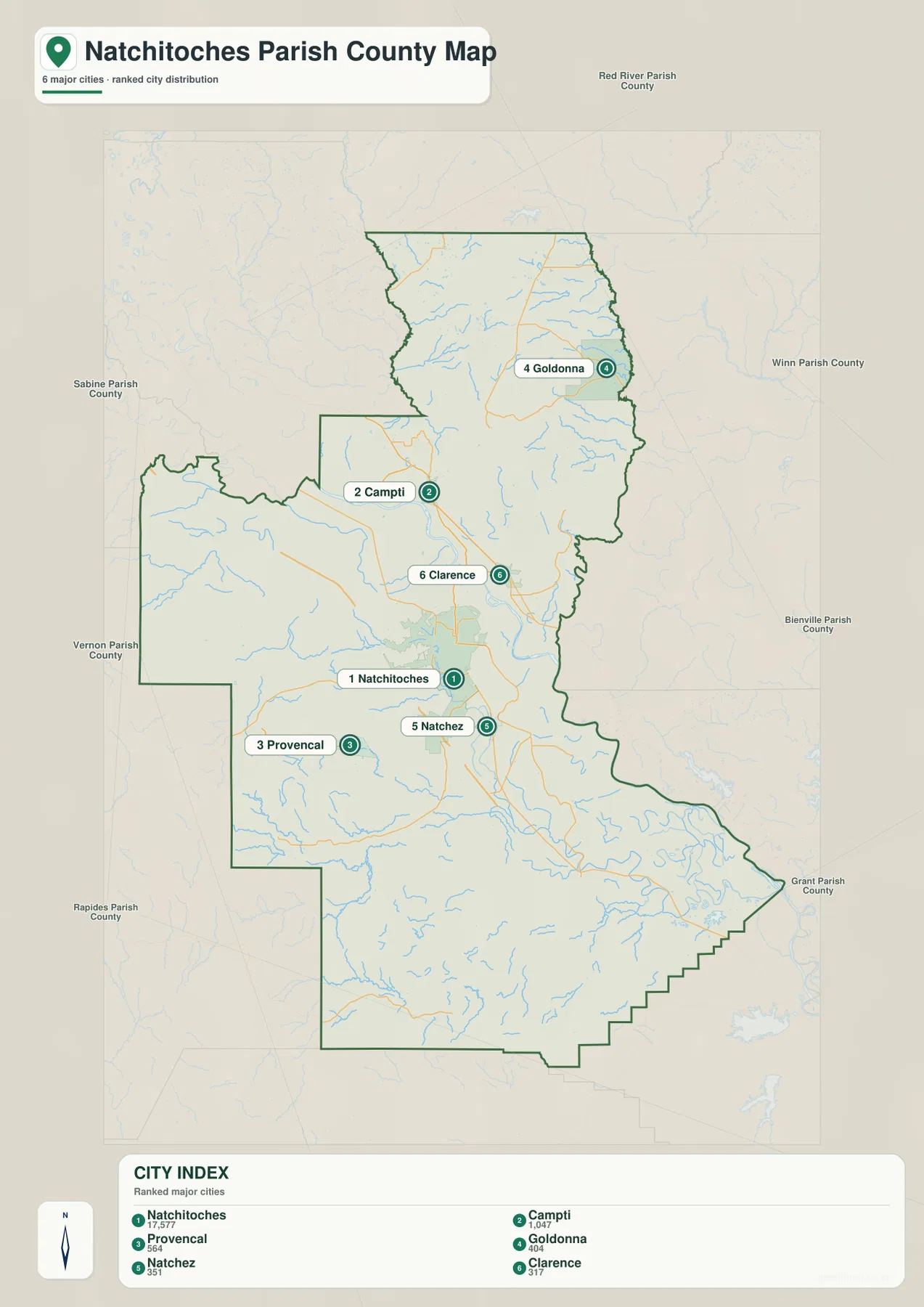
The city graphic ranks six selected places: Natchitoches is number 1, Campti 2, Provencal 3, Goldonna 4, Natchez 5, and Clarence 6. Their locations cover several different directions. Campti and Clarence are north of Natchitoches, Goldonna is much farther northeast, Provencal lies to the southwest, and Natchez is south of the city. The pattern makes the parish’s spread easy to see even with most road detail removed.
The index is intentionally selective. Ashland, Marthaville, Powhatan, and other communities visible on the general map are not among the six ranked entries. The numbers also do not represent straight-line or driving distance. Use this view when you need a quick comparison of the selected settlements, and return to the general map when the broader road network or additional community labels matter.
Black Lake and Clear Lake organize the water-rich northern half
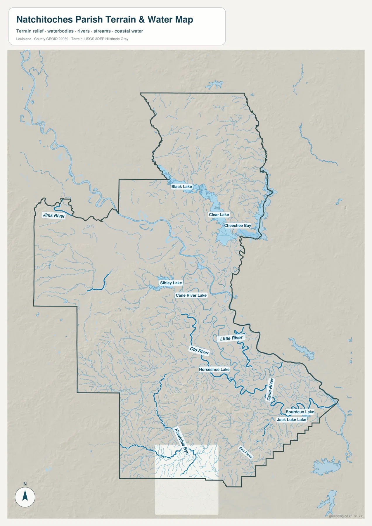
The terrain-and-water map shifts attention away from roads and toward a dense network of lakes and channels. Black Lake is one of the largest labeled features in the northern interior, with Clear Lake and Cheechee Bay to the east and southeast. Numerous thin tributaries surround these larger waters. The result is a much more detailed picture of the northern parish than the road map alone provides, especially around the broad area between Campti, Goldonna, and the eastern boundary.
Jims River is labeled near the western boundary, while Sibley Lake appears farther toward the center. These names provide useful orientation in sections where town labels are sparse. The water map should be read as a location reference rather than a hydrologic or navigation product. It does not show stream discharge, water depth, flood-zone classification, navigability, or legal property boundaries.
Cane River Lake ties the city of Natchitoches to the southern water network
Cane River Lake is the defining water feature around the city. The National Park Service explains that Cane River was once the main channel of the Red River and that dams later created a lake about 34 miles long. On the supplied water map, Cane River Lake extends through the Natchitoches area and gives the central parish a strong north-south water reference that is visible even when many smaller tributaries are ignored.
South of the city, Old River and Little River appear before the map opens into a more complicated set of channels. Horseshoe Lake lies in the same broad section. Farther southeast, Cane River bends through the lower parish near Boudreaux Lake and Jack Luke Lake, while Kisatchie Bayou becomes a major reference in the southwest. Big Bayou Pierre is also labeled near the bottom. This southern mix of long channels and lakes differs noticeably from the Black Lake system in the north.
Breaking the parish into north, center, west, and south makes the long shape easier to read
A practical way to orient yourself is to divide the parish into several reference zones. Ashland, Goldonna, Campti, and Black Lake work well for the north. Natchitoches, Clarence, and Cane River Lake organize the center. Marthaville and Provencal anchor the western projection, while Natchez, Cane River, Old River, and Kisatchie Bayou help with the south. This approach is much easier than scanning the entire elongated outline for one small label.
The best landmark also depends on the question. For roads and settlements, I-49, U.S. 84, and U.S. 71 give the clearest first references. For natural geography, Black Lake, Cane River Lake, and the southern river-and-bayou network are more useful. Small route numbers and tributary names can be difficult to read in a browser preview, so enlarging the original JPG is especially helpful when studying the northern lake system or the dense southern drainage.
High-resolution JPG files preserve the smaller route and water labels
The downloadable ZIP contains the original JPG files corresponding to the three previews on this page: the general parish map, the ranked city map, and the terrain-and-water map. Each original image is 2572 by 3638 pixels, providing more room to inspect road numbers, settlement labels, lake names, and the irregular parish boundary than the web version. The files are useful for printing, classroom material, presentations, and personal geographic reference.
Choose the general map when roads, communities, and the parish outline need to appear together. The city index is cleaner for comparing Natchitoches, Campti, Provencal, Goldonna, Natchez, and Clarence. Use the water map when Black Lake, Cane River Lake, Old River, Cane River, Kisatchie Bayou, or the smaller lakes and tributaries are the main subject. These are general reference maps rather than legal boundary, survey, flood-risk, or real-time navigation products.
Frequently Asked Questions
What is the parish seat of Natchitoches Parish?
Natchitoches is the parish seat and the largest developed place shown on the supplied map. It also provides the simplest reference for I-49, U.S. 84, U.S. 71, Cane River Lake, and the surrounding communities. Campti and Goldonna lie to the north, Provencal is southwest, and Natchez is south of the city.
Do the numbers 1 through 6 on the city map represent distance?
No. They are rankings for the six selected settlements: Natchitoches, Campti, Provencal, Goldonna, Natchez, and Clarence. The graphic does not show driving or straight-line mileage, so use the general road map and current navigation information when distance or travel time matters.
How is Cane River Lake related to the Cane River?
The National Park Service explains that Cane River was formerly the main channel of the Red River and that later dams created Cane River Lake, which is about 34 miles long. The supplied water map shows Cane River Lake around Natchitoches and the Cane River farther south within the same broad regional water network.
Map File Information
The ZIP contains the original high-resolution JPG files corresponding to the general parish map, ranked city map, and terrain-and-water map shown on this page.
- Included Files: parish map JPG, ranked city map JPG, terrain-and-water map JPG
Related Maps
Sources and references
For parish-seat and municipality information, see the Louisiana.gov Natchitoches Parish Profile and Natchitoches Parish Government. The history and formation of Cane River Lake are described by the National Park Service. General boundary data are documented by the U.S. Census Bureau TIGER/Line Shapefiles, and national water-feature data are documented through USGS National Hydrography.
Green Map creates custom-edited map images using open geographic data sources such as geoBoundaries, Natural Earth, OpenStreetMap, and government open data. These maps are edited visual materials, not raw data files, and are provided for education, documents, presentations, and graphic reference.