Marion County sits in central Kansas where Hillsboro, Marion, Peabody, Florence, and a network of smaller communities are spread across rolling uplands and broad stream valleys. The county boundary steps inward on the northeast and extends farther south around Peabody, Florence, and Burns, giving it a shape that is easier to understand from a map than from a simple rectangular outline. US 56 crosses the middle of the county, US 77 runs north–south through the eastern side, and US 50 provides an important southern reference. High-resolution map files are available for download in the section below.
This page combines road and settlement orientation with water and elevation detail. The web images are convenient previews, while the original high-resolution JPG versions of all four maps are available in one ZIP for printing, classroom use, or offline reference. The set is especially useful for distinguishing Marion Reservoir from Marion County Lake, tracing the North and South Cottonwood river systems, and comparing the higher western uplands with the lower central and eastern valleys.
Table of Contents
US 56 links Hillsboro and Marion across the county’s central corridor
The clearest organizing line on the general map is US 56. Hillsboro lies along the highway in the west-central part of Marion County, while Marion is farther east near several local route connections. A large reservoir occupies much of the area just north of this corridor between the two cities, so roads and water are closely connected in the county’s central geography. K-256 appears near Marion and helps distinguish the city from the nearby county lake area.
South of the central corridor, US 50 runs through Peabody toward Florence. US 77 comes north from the Florence area and continues past Marion toward Lincolnville and Lost Springs, making it the strongest north–south route on the eastern half of the map. K-15 provides a western north–south reference near Goessel and Durham, while K-150 reaches the eastern side of the county. Because these routes are distributed across a broad area, the most useful highway depends on whether the destination is in the central, southern, eastern, or western part of the county.
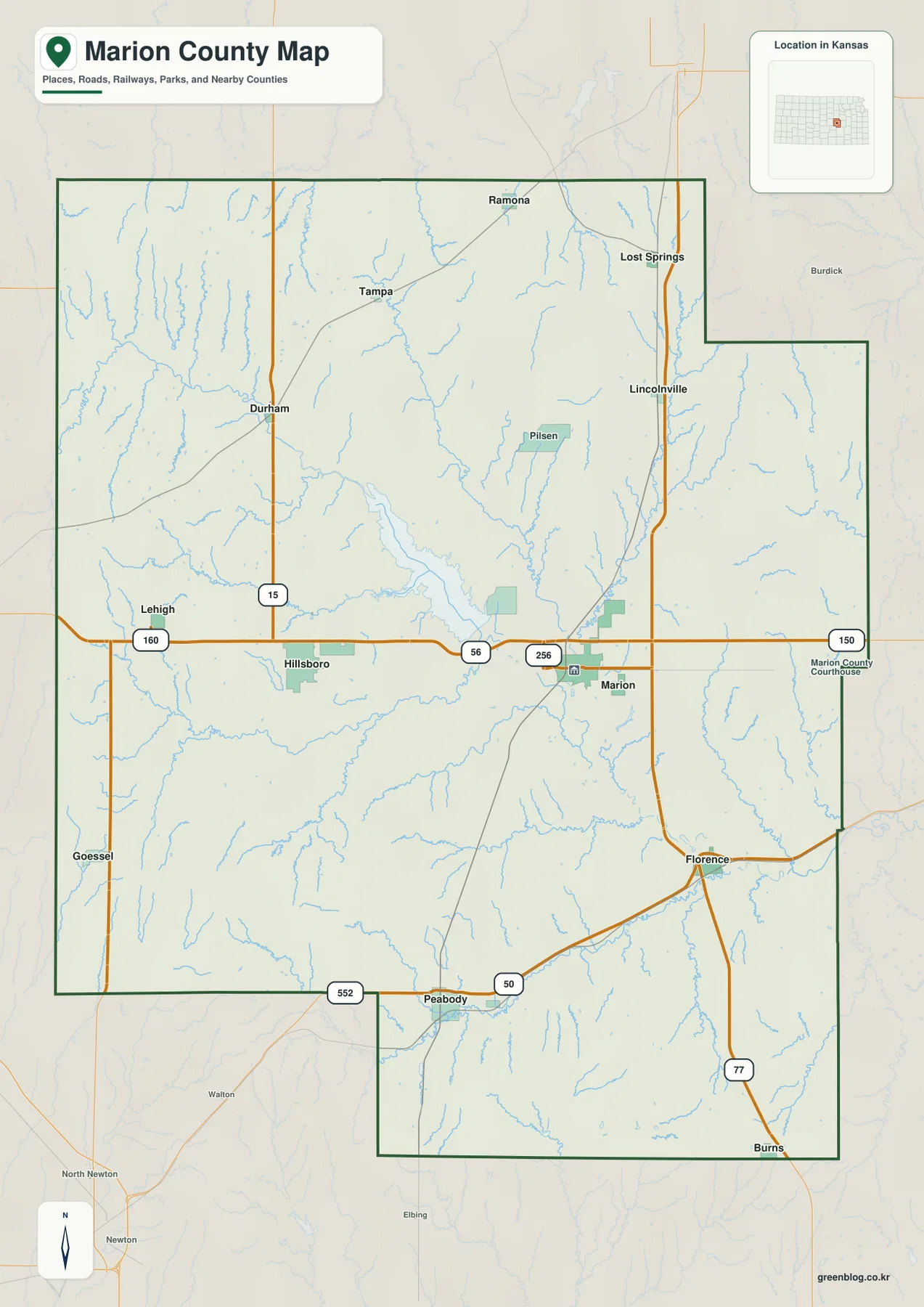
The smaller communities fill in the gaps between the main highways. Lehigh and Goessel are on the western side, Durham is northwest of Hillsboro, and Tampa and Ramona lie farther north. Lincolnville and Lost Springs are toward the northeast, while Peabody, Florence, and Burns anchor the long southern section. Seeing these places together explains why Marion County does not function as a single compact urban area; its communities are dispersed across several road corridors and drainage basins.
Six-city index emphasizes Hillsboro, Marion, and the long southward spread
The city map removes much of the road detail and highlights six major communities. In the city index printed on this map, Hillsboro ranks first at 2,700, Marion second at 1,746, Peabody third at 1,196, followed by Goessel at 610, Florence at 522, and Burns at 297. Those values should be understood as the city index used for this map rather than a substitute for the latest official population estimate, but they provide useful context for why Hillsboro and Marion receive the strongest emphasis.
The geographic pattern matters as much as the ranking. Hillsboro and Marion form a central pair, while Goessel sits well to the southwest and Peabody lies farther south. Florence is southeast of the central cities, and Burns is near the southern end of the county extension. Northern Marion County contains additional smaller places that are not part of this six-city index, so this view works best as a quick comparison of major centers rather than a complete settlement inventory.
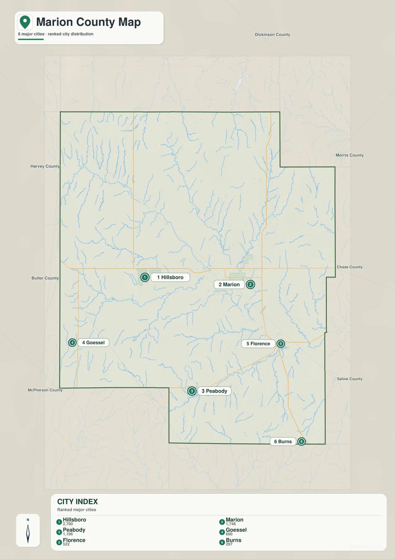
County labels around the frame provide additional orientation. Dickinson County is to the north, Morris and Chase counties are toward the northeast and east, and Harvey, Butler, and McPherson counties appear on the western and southwestern sides. Actual driving routes do not follow straight geographic relationships, but the simplified city view is useful when deciding which part of Marion County a town occupies before switching to a detailed road map or navigation service.
Marion Reservoir and Marion County Lake are two separate water bodies
The most important distinction on the water map is between the large Marion Reservoir and the smaller Marion County Lake. Marion Reservoir stretches across the central-northern area between Hillsboro and Marion and is tied to the North Cottonwood River system. Marion County Lake, by contrast, is a separate smaller water body southeast of the city of Marion. The county’s own park and lake information also distinguishes the two, which is helpful because similar names can easily cause confusion when reading a local map.
The North Cottonwood River enters from the northwest and feeds the central reservoir system, while the South Cottonwood River approaches from the west and southwest. Downstream, the Cottonwood River continues eastward through a broad low corridor. Smaller tributaries add a dense branching pattern: French Creek, Mud Creek, Clear Creek, Marion Creek, Spring Branch, Catlin Creek, Doyle Creek, and Spring Creek are all labeled. Together they show how runoff from the surrounding uplands is funneled toward larger valleys.
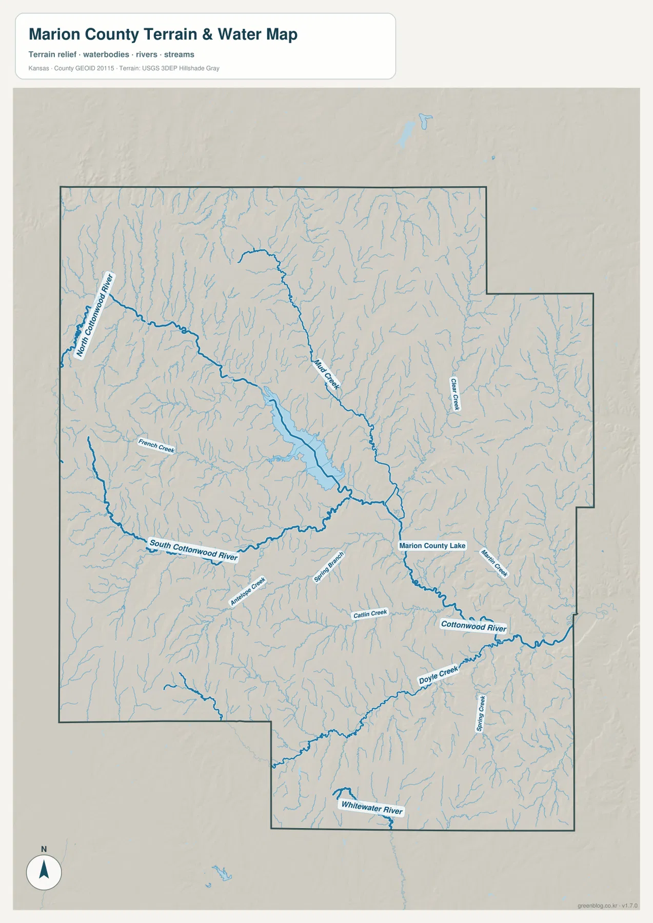
Farther south, Doyle Creek and Spring Creek join the drainage network, and the Whitewater River crosses the lower extension of the county. The shaded terrain makes it clear that these waterways occupy lower cuts between ridges rather than crossing a uniformly flat surface. Many small tributaries begin in higher ground, converge toward broader central valleys, and then leave the county through larger channels to the east or south.
This is a geographic water-reference map, not a floodplain, navigation, water-quality, or property-boundary product. A blue line identifies a mapped stream but does not indicate current depth, flow, public access, or safe boating conditions. Marion Reservoir is managed by the U.S. Army Corps of Engineers, while Marion County Lake is a separate county-managed facility, so current recreation rules and access information should be checked with the appropriate agency before a visit.
Elevation from about 377 to 488 meters reveals a higher west and lower central valleys
The elevation map gives an actual county range of roughly 377 to 488 meters, with a mean near 435 meters. Browns and warm tan colors dominate much of the west and northwest, where higher rolling ground is strongly dissected by small valleys. The central part of the county shifts into greener lower terrain, especially around Marion Reservoir and the Cottonwood drainage. The contrast makes the water network easier to understand because many stream corridors correspond directly with low, elongated bands on the elevation surface.
The western uplands are not a single flat plateau. Numerous narrow draws cut into the higher surface, creating repeated ridges and short valleys. Moving toward the reservoir and central river corridor, those smaller channels combine into broader low areas. Eastern and southeastern Marion County still contain ridges and rolling ground, but the Cottonwood River and its tributaries form obvious low routes through them.
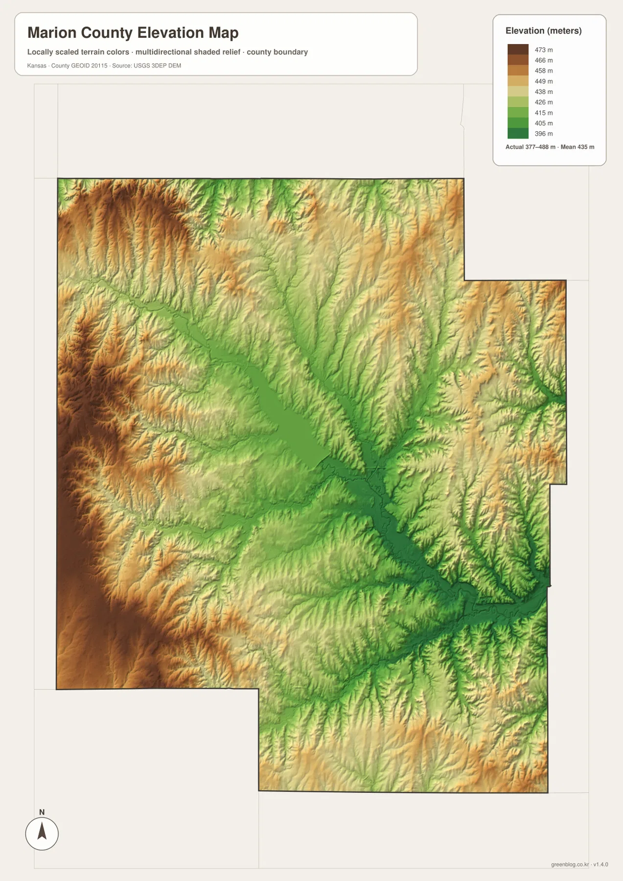
Roads and communities can be interpreted more clearly against that relief. US 56 crosses a central corridor close to the reservoir and lower drainage, while terrain rises more noticeably toward parts of the west. Around Peabody and Florence, the surface is also broken by creek valleys rather than remaining level from one town to the next. Comparing this image with the water map helps explain why many small creeks descend from the uplands and join larger channels in the center and southeast.
The elevation colors are intended for county-scale comparison, not parcel surveying or engineering design. They can show that one broad area is higher or lower than another, but they do not replace detailed site data, precise contours, or professional field measurements. For education, regional planning, or general landscape interpretation, the image is most useful for separating the western uplands from lower reservoir and river corridors.
The central reservoir ties roads, towns, and drainage into one geographic picture
Marion Reservoir is more than a large blue shape on the map; it is a practical reference point for understanding central Marion County. On the road map, US 56 passes just south of the reservoir as it connects Hillsboro and Marion. On the water map, the North Cottonwood River and other drainage lines feed toward the reservoir system. On the elevation map, the same area appears as a broad low green corridor surrounded by higher rolling terrain, linking transportation, settlement, water, and relief in a single location.
The separate Marion County Lake adds a second local landmark closer to the city of Marion. The county’s official Park & Lake page identifies this smaller lake as a county-operated recreation area and explicitly distinguishes it from the larger Marion Reservoir. That distinction matters when planning a visit or reading directions because a search for “Marion Lake” can refer to different places depending on context. Checking both the name and the position relative to Marion and US 56 avoids most confusion.
U.S. Army Corps of Engineers recreation information describes Marion Reservoir as a managed destination for camping, boating, fishing, and wildlife activities. The county maps here are not facility maps and do not show individual campground entrances or current closures, but they provide a clear regional frame before using more detailed visitor information. They also explain why the reservoir is a prominent feature in both the physical landscape and the road network between Hillsboro and Marion.
Peabody, Florence, and Burns occupy a distinct southern extension
Southern Marion County stands out because the boundary extends well below the main east–west body of the county. Peabody sits near the western side of this extension, Florence is farther east where US 50 and US 77 come close together, and Burns lies near the southern end. Their spacing is substantial compared with the central Hillsboro–Marion pair, so a map focused only on the county seat would miss an important part of the county’s settlement pattern.
The southern water network has its own character as well. Doyle Creek and Spring Creek occupy the southeast, while the Whitewater River crosses the lower portion. On the elevation map, green stream valleys are separated by warmer-colored ridges and rolling uplands rather than forming one continuous flat plain. Looking at roads, water, and relief together gives a better sense of how Peabody, Florence, and Burns relate to the rest of Marion County.
Choosing the right Marion County file for roads, towns, water, terrain, or print
Choose the general county map when the priority is roads, communities, county boundaries, and surrounding counties in one view. The city index is better for quickly comparing Hillsboro, Marion, Peabody, Goessel, Florence, and Burns without route clutter. Use the terrain-and-water map when the question involves Marion Reservoir, Marion County Lake, the Cottonwood river system, or named creeks. The elevation map is the strongest choice for explaining the higher western terrain and lower central river corridors.
The four files also work well in sequence. A reader can locate Hillsboro and Marion on the city map, switch to the general map to identify US 56, then use the water map to place Marion Reservoir between them. For Peabody or Florence, the road map provides the US 50 context and the elevation map shows the surrounding valley-and-ridge pattern. Moving between layers in this way keeps each individual map readable while still connecting multiple types of information.
For large prints, posters, or presentation slides, use the original JPG files in the ZIP rather than enlarging the web previews. The high-resolution files preserve small route numbers, city labels, stream names, and the elevation legend more effectively. If a map is cropped for a handout, keep the legend or key labels visible whenever they are necessary to understand elevation or water features.
Frequently Asked Questions
Are Marion Reservoir and Marion County Lake the same place?
No. Marion Reservoir is the much larger water body between Hillsboro and Marion and is connected with the North Cottonwood River system. Marion County Lake is a separate, smaller county-managed lake southeast of the city of Marion. The water map makes the difference easiest to see because both water bodies can be compared in the same county context.
Which map is best for comparing Hillsboro and Marion along US 56?
Use the city map for the simplest town-to-town comparison, then use the general county map when you need the highway and reservoir context. The general map shows US 56 crossing the central county between Hillsboro and Marion, with the large reservoir just north of the corridor.
Can the 377–488 meter elevation range be used for property surveying?
No. The elevation map is a generalized county-scale terrain surface intended to compare uplands and valleys. It is not survey-grade information for an individual parcel, building site, drainage design, or boundary decision. Precise work requires appropriate detailed elevation data and, when necessary, professional field surveying.
Map File Information
The archive contains the Marion County, Kansas general county map, city map, terrain-and-water map, and elevation map as original high-resolution JPG files for printing and offline use.
- Included Files: Use only the versions confirmed in the article and supplied images
- File Type: Use the confirmed download contents
- Intended Use: Printing, education, presentations, and map-based projects
Related Maps
Sources and references
- Marion County, Kansas official website — county administration and local information
- Marion County Park & Lake — official distinction between Marion County Lake and Marion Reservoir
- U.S. Army Corps of Engineers / Recreation.gov: Marion Reservoir — reservoir location, management, and recreation context
- U.S. Census Bureau TIGER/Line Shapefiles — county boundary and geographic reference data
- USGS National Hydrography — river and stream reference data
- USGS 3D Elevation Program — elevation and terrain reference data
Green Map creates custom-edited map images using open geographic data sources such as geoBoundaries, Natural Earth, OpenStreetMap, and government open data.
These maps are edited visual materials, not raw data files, and are provided for education, documents, presentations, and graphic reference.