An Ireland Map can describe either a state or an entire island, so the boundary treatment matters as much as the coastline. The three supplied graphics show all of the island, but their detailed county divisions cover the 26 counties of the Republic of Ireland. Northern Ireland appears as a separate area labeled “U.K.” without its six counties being divided internally.
This distinction makes the collection useful for readers who need to explain the island’s geography without confusing it with the political extent of the Republic. The labeled color and monochrome editions also place the Atlantic Ocean, North Channel, Irish Sea, and Celtic Sea around the coast. Dublin is marked by name within its county, while the other labels identify county areas rather than precise city locations.
The Ireland Map set contains three coordinated versions: a pastel county map, a black-and-white labeled map, and an unlabeled outline. They share the same 1,200 × 849 published-preview canvas and boundary geometry. Teachers, students, writers, and designers can therefore move between recognition, monochrome printing, and custom annotation without changing the underlying spatial reference.
Table of Contents
Ireland Map Overview
Reading the Island and the State
The island of Ireland lies west of Great Britain in the North Atlantic. The Republic of Ireland occupies most of the island, and Northern Ireland is part of the United Kingdom. On this Ireland Map, a heavier dashed boundary separates the two jurisdictions, color fills stop at that line, and the northern area is shown in gray with a U.K. label.
The 26 labeled counties are Donegal, Sligo, Leitrim, Cavan, Monaghan, Louth, Mayo, Roscommon, Longford, Westmeath, Meath, Dublin, Galway, Offaly, Kildare, Wicklow, Clare, Laois, Tipperary, Kilkenny, Carlow, Wexford, Limerick, Kerry, Cork, and Waterford. Their names are presented in English only. The maps do not show Irish-language forms, county towns, roads, transport lines, or local-government subdivisions within the counties.
County shapes become especially compact in the east and Midlands, where Dublin, Meath, Kildare, Wicklow, Offaly, Westmeath, Longford, Laois, Carlow, and Kilkenny meet within a relatively small part of the page. Western counties such as Mayo, Galway, Clare, Kerry, and Cork have more irregular Atlantic-facing coastlines. Donegal extends around the northwestern edge, visually separated from the rest of the Republic by Northern Ireland’s position.
Visible Scope and File Limits
All three published body images measure 1,200 × 849 pixels in a landscape ratio. The protected FAQ confirms that the downloadable maps were designed for A3 dimensions, but the previews should not be mistaken for vector source files. The images can receive annotations in ordinary graphics software; their county boundaries are not supplied here as independently editable GIS or vector objects.
The coast includes many bays, peninsulas, headlands, and offshore islands, particularly along the west and southwest. Those forms are simplified enough to remain legible at page scale while still preserving the island’s recognizable outline. No map in the set displays terrain, elevation, rivers, roads, population data, tourist attractions, or the six historic counties of Northern Ireland as separate units.
Regional Color Map
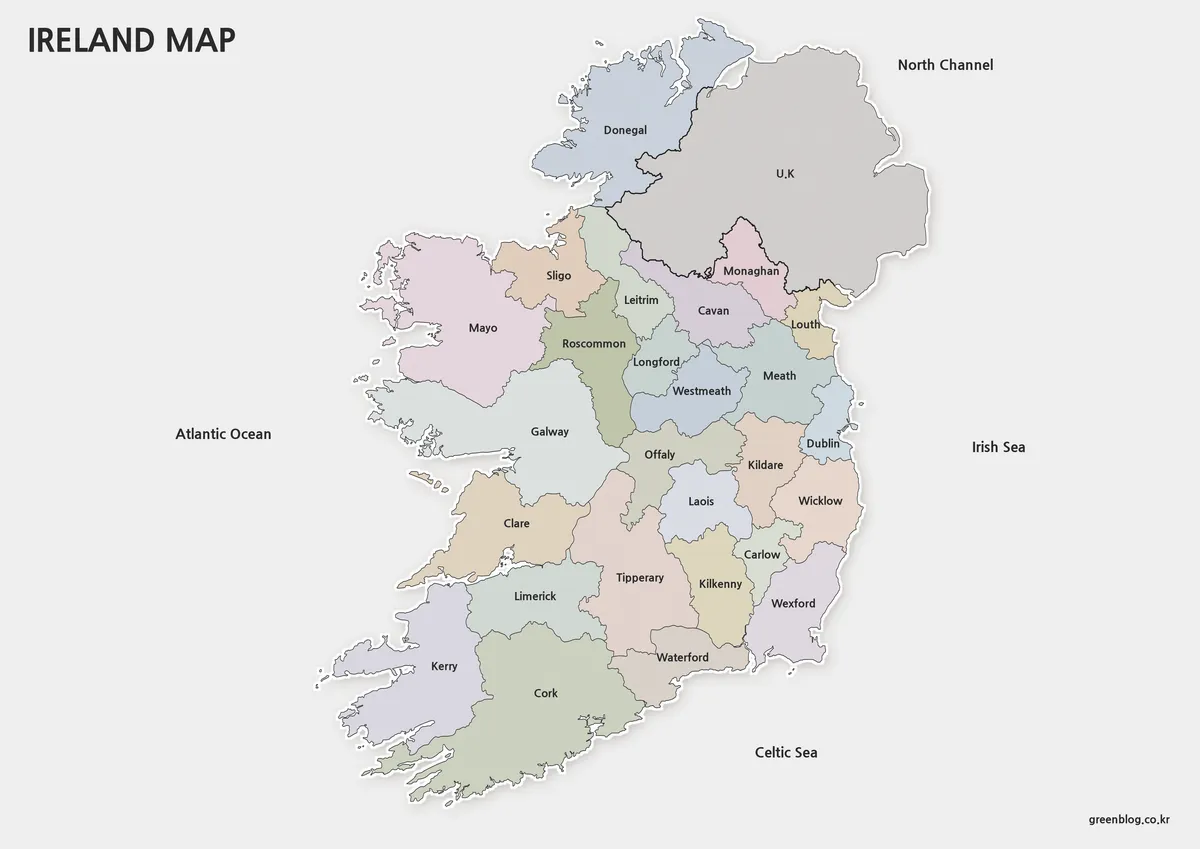
The color Ireland Map assigns a different muted fill to each of the Republic’s 26 counties. Northern Ireland remains gray, making the jurisdictional distinction visible before the reader studies individual labels. Pale gray surrounding water keeps the coastline clear, while the four water labels establish orientation on every side of the island.
Color is most helpful in the central and eastern clusters, where short boundaries and small county shapes would otherwise compete for attention. It also makes the long Atlantic-facing progression from Donegal through Mayo and Galway to Clare, Kerry, and Cork easier to follow. The palette is categorical only and does not represent population, province, political control, land use, or another measured variable.
This edition suits an introductory lesson, a presentation about county locations, or a report that needs an immediate visual distinction between adjacent areas. When adding statistics, create a separate legend and cite the data source and date. Do not reuse the original pastel colors as if they already encode numerical categories.
Basic Printable Map
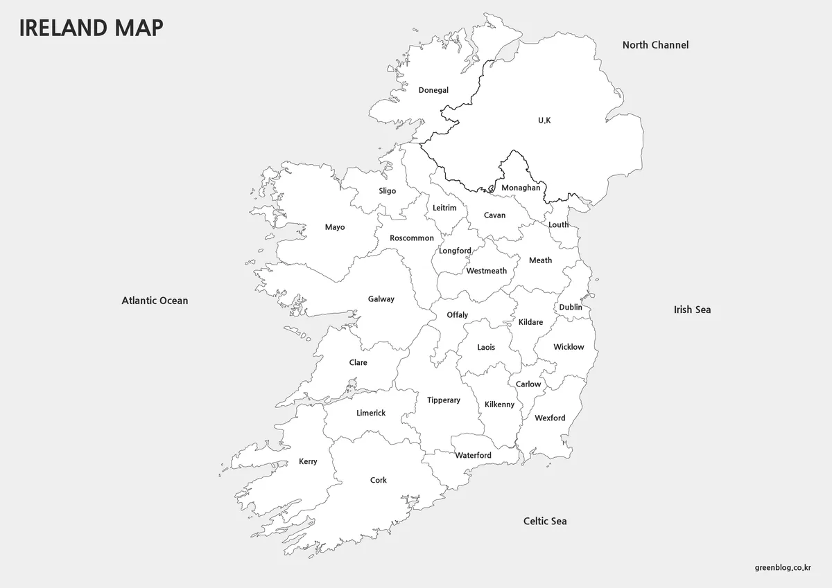
The basic Ireland Map retains county names, the Dublin label, coastal outlines, the border treatment, the U.K. label, and all four surrounding water names. Removing the pastel fills reduces visual competition and leaves open interiors for handwritten notes or a small number of user-added highlights.
Use this version for photocopied worksheets, restrained reports, or exercises that ask learners to locate named counties without relying on a color key. A teacher might highlight the counties along the Irish Sea, trace the border counties, or compare the broken western coast with the smoother eastern side. Because every label is already present, it is a reference sheet rather than a blank recall test.
Before printing a large batch, inspect the smaller labels in the Midlands and east at the chosen scale. Longford, Westmeath, Offaly, Laois, Carlow, and nearby counties occupy narrow spaces. Preserving the original aspect ratio and using fit-to-page scaling will prevent the island from being stretched or clipped.
Outline Map for Editing
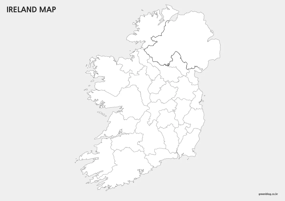
The outline Ireland Map removes county names, water labels, the U.K. text, and all area fills. It preserves the island’s outer coast, the 26 county boundaries in the Republic, and the heavier separation around Northern Ireland. The printed page title and small site mark remain part of the image, so this is an unlabeled geographic field rather than a fully blank transparent asset.
For classroom work, learners can label all 26 counties, identify only the border counties, or color counties by the four traditional provinces using a separately explained key. Province groupings are not drawn in the source map, and Northern Ireland’s counties are absent, so an exercise should not imply that the image contains every one of the island’s 32 traditional counties.
For graphic projects, keep an untouched master and add text, fills, arrows, or point markers on separate layers. The outline can support a sourced thematic comparison, a simplified travel path, or a custom county-selection graphic. It should not be used as a precise surveying boundary, navigation map, or substitute for current official geospatial data.
Practical Uses
Selecting the right Ireland Map depends on what the reader must do. The color edition is quickest for recognizing adjacent counties and the separate Northern Ireland area. The monochrome edition works better when labels must remain visible in a low-color document. The outline provides the most open space for quizzes, custom shading, location points, or annotations.
- County reference: use the labeled color or monochrome edition.
- Classroom recall: use the outline and supply an accurate county list.
- Thematic graphics: add sourced values, a date, units, and a clear legend.
- Jurisdictional explanation: clarify that Northern Ireland is shown as one U.K. area.
None of the versions should be used for road navigation, terrain analysis, or a complete 32-county historical-island exercise without additional information. The key strength of the collection is narrower: it presents the Republic’s 26 county shapes within the geographic context of the whole island and surrounding waters, with consistent geometry across three visual treatments.
Frequently Asked Questions
The following answers explain the simplification, A3 preparation, and annotation options in the Ireland Map files.
What was simplified in the map design?
Roads, facilities, and highly detailed geographic elements were removed so regional boundaries and overall structure remain easy to understand.
Can I print the map at A3 size?
Yes. The maps were designed at A3 dimensions and reviewed for readability when printed.
Can I edit the colors or labels?
Yes. The basic and outline versions were prepared with editing in mind and work well for custom projects.
Map File Information
The ZIP archive contains three coordinated island maps showing the Republic’s county framework and Northern Ireland context.
- Included Versions: Labeled color, labeled black and white, and unlabeled outline maps
- Printable Size: Prepared for A3 output
- File Type: Image files supplied in a ZIP archive
- Intended Use: County reference, lessons, presentations, printing, and annotations
Related Maps
Additional Resources
- Ireland.ie — Official International Website — Explore government information about Ireland, its international presence, culture, study, travel, and public services.
Green Map creates custom-edited map images using open geographic data sources such as geoBoundaries, Natural Earth, OpenStreetMap, and government open data.
These maps are edited visual materials, not raw data files, and are provided for education, documents, presentations, and graphic reference.