Andrew County lies in northwest Missouri, with Savannah providing the clearest starting point for roads and settlement. On the supplied general map, U.S. 59 runs through the county toward Savannah, U.S. 71 connects the south side, and I-29 lies close to the southern approach from St. Joseph. Fillmore and Amazonia sit near the western river boundary, Bolckow and Rea are farther north, and Cosby is on the eastern side. The four maps on this page—general, city, water, and elevation—are also available as high-resolution JPG originals in the downloadable ZIP below.
The terrain explains why the county feels more divided than the road map first suggests. The Nodaway River and its old channel follow the western side, the One Hundred and Two River cuts a long valley through the interior, and the Platte River system appears in the southeast. Smaller creeks carve additional low corridors between narrow ridges. The elevation legend reports an actual range of about 244 to 357 meters and a mean near 299 meters, creating repeated ridge-and-valley relief across the county.
Table of Contents
Savannah connects U.S. 59 with the southern I-29 approach
Savannah sits a little south of the center of Andrew County and is the easiest settlement to locate on the general map. U.S. 59 approaches from the north and passes the Savannah area, while U.S. 71 and the southern road network lead toward I-29 and St. Joseph. Andrew County’s official directions also describe reaching Savannah from St. Joseph or Kansas City by taking I-29 to the Savannah exit and then continuing on U.S. 71. That makes the southern highway connection an especially useful orientation point.
North of Savannah, Missouri Route 48 crosses the north-central part of the county, with Rea and Bolckow serving as useful nearby place references. Along the east side, U.S. 169 runs north–south near the county line, with Union Star and King City labeled beyond the border. Fillmore occupies a very different setting near the Nodaway River on the west, where the road network bends around drainage features rather than following the straighter pattern visible in some eastern sections.
Southwest of Savannah, Amazonia lies close to the broad river-side lowland. Country Club is farther south and closer to the St. Joseph side of the county. The map also shows Route 229 and I-29 near the southern edge, with U.S. 71 linking the area northward toward Savannah. Together, these routes reveal a county whose largest settlement is inland but only a short distance from a major interstate corridor.
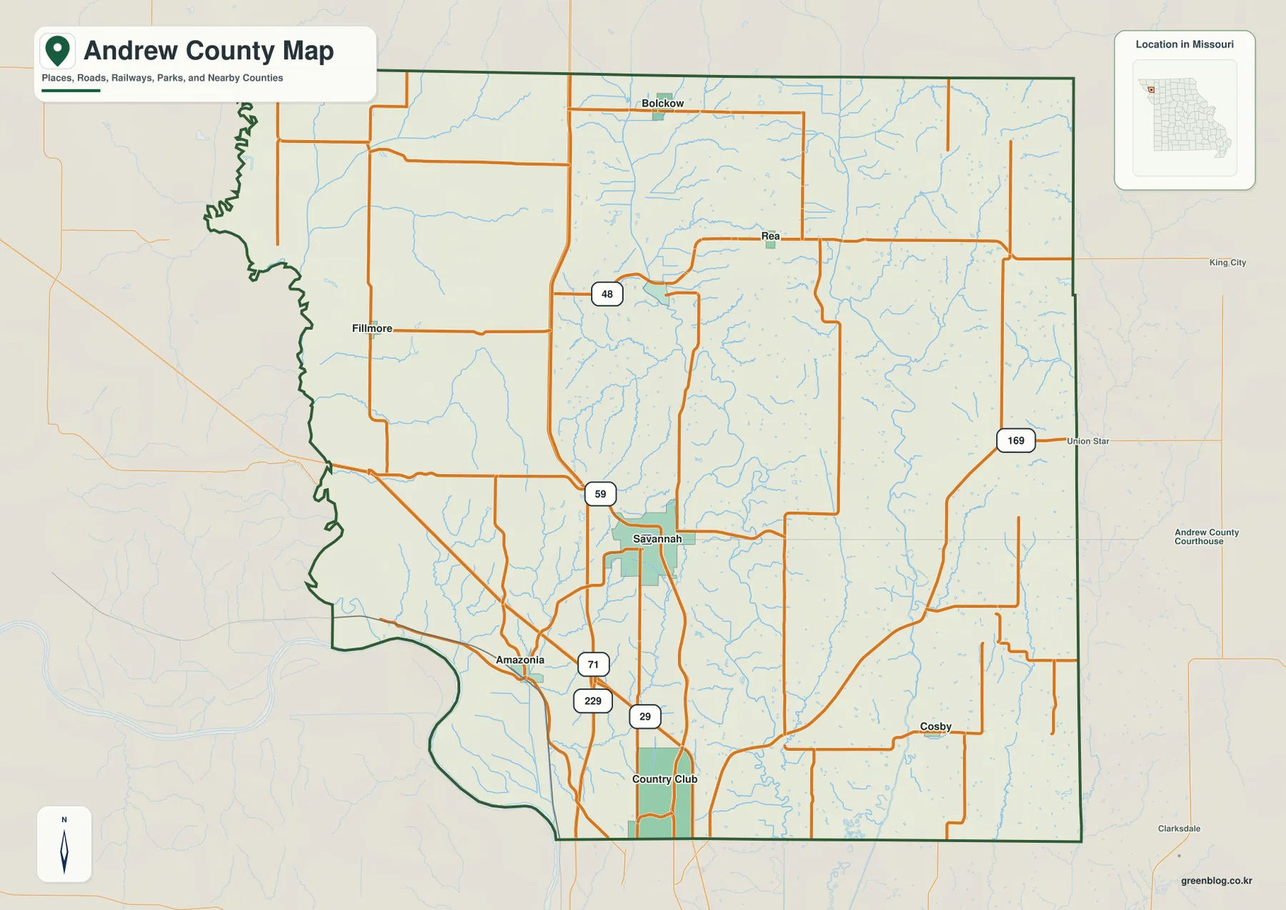
The western county line is irregular because it follows river channels rather than a straight survey line. The eastern boundary is much straighter, and U.S. 169 parallels part of that side. Reading Andrew County as three broad settings—western river country, the Savannah-centered interior, and the eastern rural side—makes the general map easier to understand than trying to memorize every road at once.
Andrew County’s official website identifies Savannah as the county seat and lists communities including Amazonia, Bolckow, Fillmore, Rosendale, and Savannah. The supplied map places those settlements across different road and drainage settings, which helps explain the long distances between some of the smaller places. For live closures or road construction, the static county image should be supplemented with current transportation information.
Savannah and Country Club dominate the six-place city view
The city map ranks six highlighted communities. Its CITY INDEX lists Savannah at 5,053, Country Club at 2,935, Fillmore at 299, Amazonia at 286, Bolckow at 197, and Rosendale at 130. These figures are the reference values printed on the supplied map and are best used to compare the relative scale of the highlighted places. The latest official population figures should be checked in current Census data when needed.
Savannah is the largest highlighted center and sits in the south-central part of the county. Country Club, the second-largest entry, lies farther south toward the St. Joseph side. The two places form the most substantial southern settlement pair on the map, but they remain separate communities rather than one continuous city area. Their position also helps explain why the county’s strongest highway connections are concentrated toward the south.
Fillmore and Amazonia both occupy the western half but in different river settings. Fillmore is farther north along the Nodaway side, while Amazonia lies near the large southwest bend in the boundary. Bolckow appears near the northern middle, and Rosendale is south of it in the north-central interior. The six-place distribution therefore shows a distinct southern concentration around Savannah and Country Club, with smaller towns spread across the west and north.
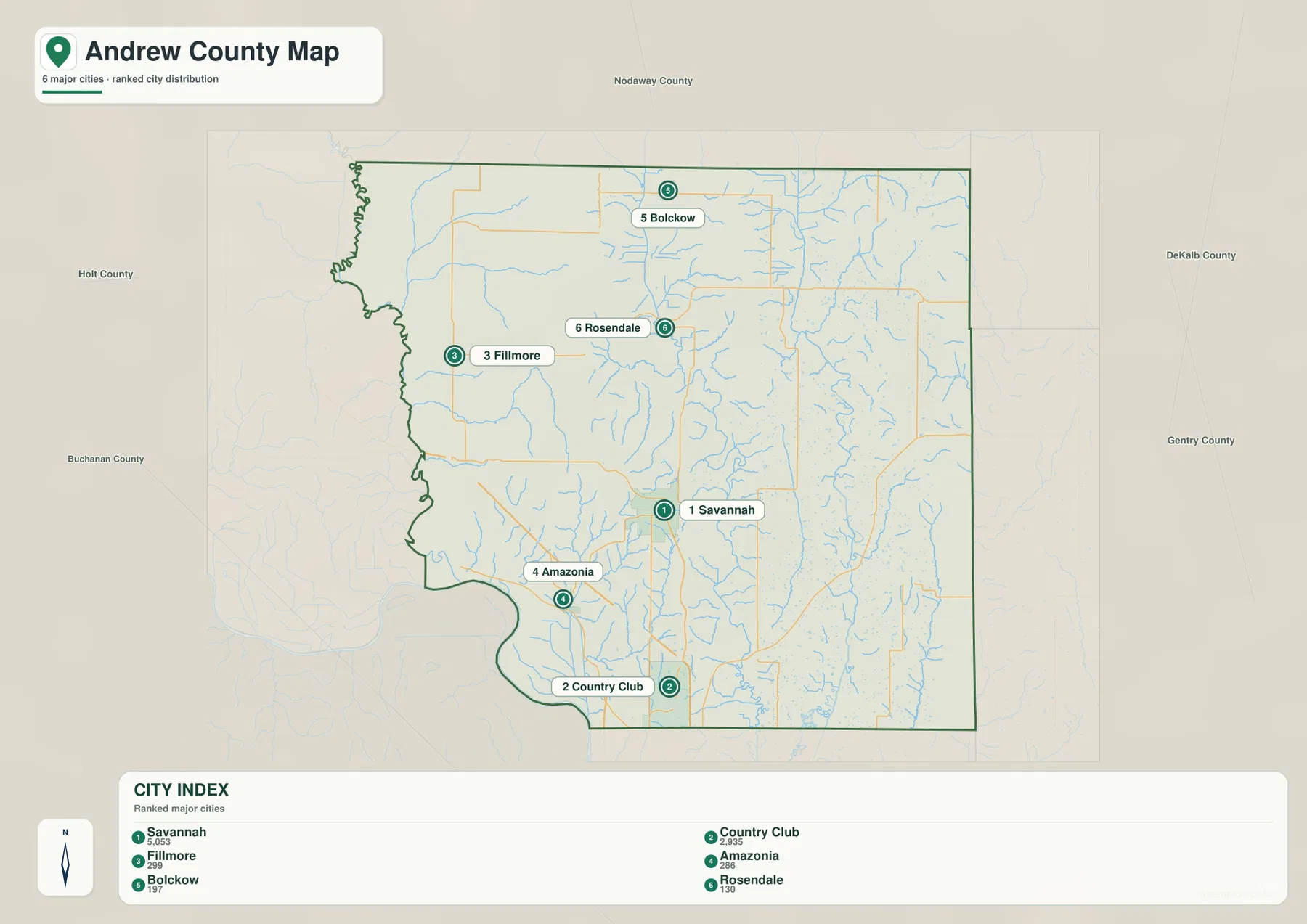
The city map is not a driving-distance diagram. It simplifies the county by removing many smaller roads and places, making it useful for comparing the location and relative scale of the six highlighted communities. For an actual route from Savannah to Fillmore, Amazonia, or Bolckow, the general road map or a current navigation service is the better source.
Comparing the city and general maps also shows what each view leaves out. Rea and Cosby, for example, are visible on the general map but are not part of the six-place city index. The city view is therefore best for a quick settlement comparison, while the general map is the better choice when smaller communities and highway connections matter.
The Nodaway and One Hundred and Two rivers define separate valleys
The strongest western water feature is the Nodaway River. The Old Channel Nodaway River is labeled in the northwest, while the present river follows the irregular western boundary farther south. Broad low terrain accompanies the river, making it an important reference for Fillmore, Amazonia, and the county’s western outline.
The One Hundred and Two River is the dominant interior waterway. It runs from the northern part of the county toward the south through a long, clearly defined valley. Numerous short tributaries enter from both sides, and the same corridor appears as a broad green lowland on the elevation map. Its central position makes it one of the most useful features for dividing the western Nodaway country from the eastern drainage network.
On the eastern side, Crooked Creek and Hickory Creek are among the named tributaries, while the Platte River is labeled near the southeast. Muddy Creek runs through the southern east side, and Lincoln Creek drains toward the west. Unlike a lake-dominated county, Andrew County is characterized by many narrow streams and branching valleys spread across nearly the entire map.
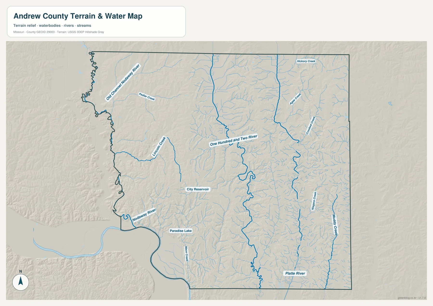
Two small water bodies provide useful additional landmarks. City Reservoir lies west of Savannah, and Paradise Lake appears farther southwest between the Savannah and Amazonia/Country Club side. Neither is as geographically dominant as the major rivers, but they help connect the water view back to familiar settlements on the general map.
Missouri Department of Conservation describes Hadorn Bridge Access as a public area on the One Hundred and Two River northeast of Savannah. The agency notes that the property protects river-associated habitat and provides public access for compatible outdoor activities. That site-specific information complements this county-scale view, which shows the broader river corridor and its many tributaries.
The water map is intended for geographic orientation rather than flood-risk, water-depth, water-quality, legal-boundary, or boating decisions. Those questions require current specialized sources. For general use, trace the Nodaway River first, then the One Hundred and Two River, and finally the Platte-side streams to understand how drainage divides Andrew County into several narrow valley systems.
Elevation of 244–357 meters repeats in narrow ridges and low stream corridors
The elevation legend gives an actual county range of about 244 to 357 meters and a mean near 299 meters. Dark green follows the major lowlands, especially the Nodaway River along the west and the One Hundred and Two River through the interior. Yellow, tan, and brown ridges rise between those valleys. The total relief is a little over 100 meters, but it repeats over short distances and gives the shaded map a strongly textured appearance.
In the western part of Andrew County, the low river boundary is immediately followed by higher ground inland. Between Fillmore and Amazonia, many small tributaries cut back into the uplands, producing a series of narrow spurs and valleys. This helps explain why some roads curve rather than following long straight lines across the map.
The interior One Hundred and Two River corridor forms another conspicuous green band, with elevated terrain on both sides. Savannah itself is not located in one broad flat basin; smaller valleys and ridges surround the city. Farther east, Crooked Creek and the Platte system create additional low strips separated by higher brown uplands.
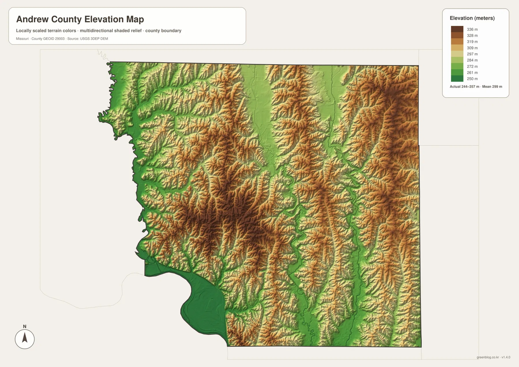
The northern and eastern parts continue the same ridge-and-valley pattern rather than forming a single smooth slope. Small streams repeatedly cut the higher ground, so the county looks almost leaf-veined on the shaded relief image. A better description is therefore a network of low drainage corridors separated by narrow uplands, not simply a west-to-east rise or a uniformly rolling plain.
This elevation image is generalized for county-scale comparison. It should not be used to determine the exact height of a parcel, road grade, drainage structure, or construction site. Those tasks require source elevation data, field checks, and surveying where appropriate. For ordinary map reading, the image is most useful for connecting Andrew County’s roads and settlements with the valleys created by its rivers and creeks.
A useful sequence for combining the four Andrew County maps
Start with Savannah on the general map and identify U.S. 59, U.S. 71, and the nearby southern I-29 approach. Then place Country Club to the south, Fillmore and Amazonia to the west, and Bolckow and Rosendale farther north. Adding U.S. 169 along the eastern side gives the county a simple road framework before the smaller routes are considered.
Next, use the water map to trace the Nodaway River on the west and the One Hundred and Two River through the middle. City Reservoir west of Savannah provides an easy local landmark, while the Platte River and eastern creeks complete the drainage picture. On the elevation map, the same rivers become green lowlands bordered by tan and brown ridges, revealing how closely the water network and terrain fit together.
Choose the general map for highways, local places, and the county boundary. Use the city view when the relative location and size of six highlighted communities matter most. The water map is the clearest source for rivers, creeks, and reservoirs, while the elevation map emphasizes the 244–357 meter ridge-and-valley relief. Keeping those roles separate makes the maps easier to use for printing, classwork, presentations, or personal reference.
Frequently Asked Questions
Where is Savannah within Andrew County?
Savannah sits slightly south of the county center and is the main road reference on the supplied map. U.S. 59 and U.S. 71 connect through the area, and I-29 is close to the southern approach from St. Joseph. Andrew County’s official website identifies Savannah as the county seat.
Which rivers are the easiest landmarks in Andrew County?
The Nodaway River follows the western side, while the One Hundred and Two River runs through the interior. The Platte River and several creeks occupy the eastern and southeastern side. Together, these waterways create the low valleys that are most visible on the elevation map.
What elevation range is shown on the Andrew County map?
The legend reports an actual range of about 244 to 357 meters and a mean near 299 meters. Major river valleys appear as lower green corridors, while the ridges between them rise into yellow and brown. The image is for broad comparison rather than survey-grade measurements.
Map File Information
The ZIP contains the high-resolution JPG originals of the Andrew County general map, city map, water map, and elevation map shown on this page.
- Included Files: 4 high-resolution JPG maps
Related Maps
Sources and references
- Andrew County, Missouri official website — county government, communities, and Savannah county-seat information
- Andrew County About Us — county history and regional river information
- Missouri Department of Conservation — Hadorn Bridge Access — official public access information for the One Hundred and Two River
- U.S. Census Bureau TIGER/Line Shapefiles — county boundaries and geographic reference data
- USGS National Hydrography — rivers, streams, and water features
- USGS 3D Elevation Program — elevation and terrain reference data
Green Map creates custom-edited map images using open geographic data sources such as geoBoundaries, Natural Earth, OpenStreetMap, and government open data. These maps are edited visual materials, not raw data files, and are provided for education, documents, presentations, and graphic reference.