Virginia’s population geography is dominated by several large urban systems separated by broad rural and mountain regions. Northern Virginia contains the strongest current concentration along the Washington, D.C. edge, with Fairfax, Arlington, Alexandria, Loudoun, and Prince William forming a large connected settlement pattern. Hampton Roads creates another major concentration around Virginia Beach, Norfolk, Chesapeake, Newport News, Hampton, and Portsmouth. Richmond and its surrounding Henrico and Chesterfield counties anchor central Virginia, while Roanoke, Lynchburg, Harrisonburg, and Charlottesville stand out as smaller western and interior hubs.
The supplied 2024 ACS 5-year estimates put Virginia’s population at 8,705,170. The county-density map reports about 39,481 square miles of land and a statewide average near 220 people per square mile. Virginia has an important administrative wrinkle: independent cities are county-equivalent units, so Alexandria, Richmond, Norfolk, Virginia Beach, and other independent cities are compared alongside counties in the county-level maps. The largest population, highest density, and fastest 2010–2020 growth belong to different county-equivalent areas.
Table of Contents
Northern Virginia forms the broadest tract-level high-density cluster
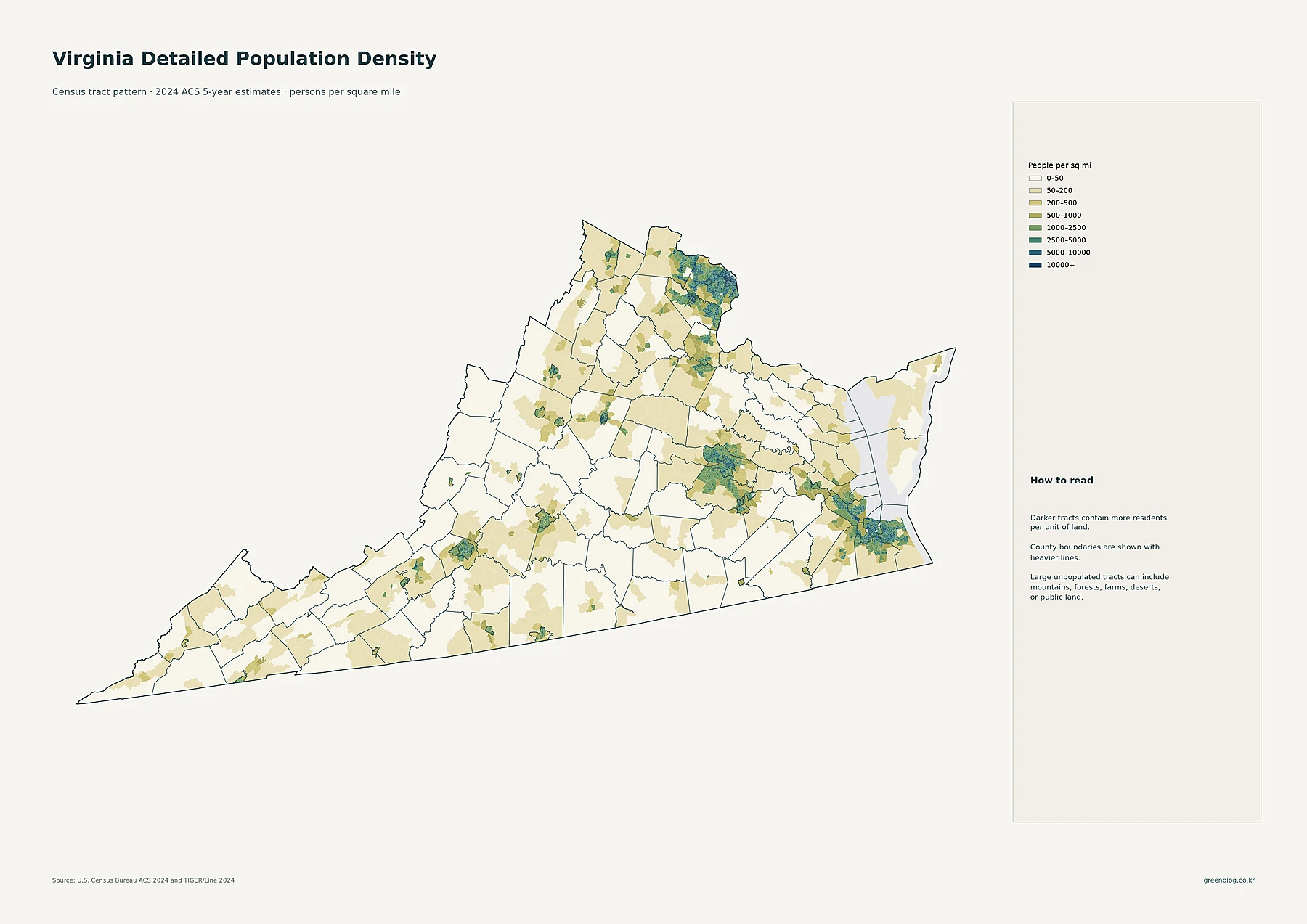
The darkest tracts are concentrated around Arlington and Alexandria and spread west and southwest through Fairfax County. Medium- and high-density settlement extends into communities such as Centreville, Reston, McLean, and Dale City. Eastern Loudoun County also contains a strong suburban concentration around Leesburg and the Washington-area edge. The pattern crosses multiple county and city boundaries, making Northern Virginia look like one broad metropolitan settlement system rather than a collection of isolated jurisdictions.
Hampton Roads forms the second major concentration. Norfolk and Portsmouth contain compact dark tracts, while higher-density settlement continues through Chesapeake, Virginia Beach, Hampton, and Newport News. The region is broken visually by waterways, but the overall pattern remains one large southeastern population system. Central Virginia has another cluster around Richmond, Henrico, and Chesterfield, with additional growth and settlement extending north through Fredericksburg, Stafford, and Spotsylvania.
Western Virginia is much more dispersed. Roanoke, Lynchburg, Harrisonburg, and Charlottesville appear as localized islands of density, surrounded by broad tracts in the 0–50 or 50–200 people-per-square-mile classes. The southwestern Appalachian counties are especially sparse. The tract map therefore reveals local urban centers that would be obscured by countywide averages.
Virginia Beach is the largest census place, while Hampton Roads contains several major cities
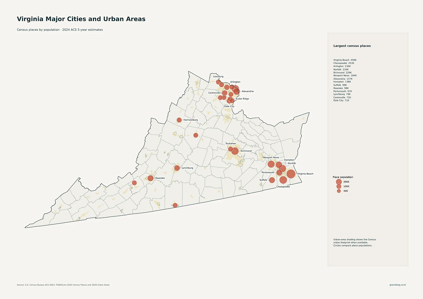
Virginia Beach has 456,349 residents in the supplied census-place data, making it the largest place in Virginia. Chesapeake follows with 252,583, Arlington with 236,254, Norfolk with 233,596, and Richmond with 229,359. Newport News has 184,216 residents, Alexandria 156,976, and Hampton 137,557. Suffolk has 98,796, Roanoke 98,355, Portsmouth 97,190, and Lynchburg 79,497.
The map makes the Hampton Roads concentration especially clear because several of the state’s largest circles sit close together. Northern Virginia has a different pattern: Arlington and Alexandria are large census places, while several unincorporated or census-designated communities also appear with substantial populations, including Centreville at 71,706, Dale City at 71,016, Reston at 64,414, McLean at 49,627, and Leesburg at 49,171.
The proportional circles represent total place population, not density. Virginia Beach has the largest place population, but it is not the densest county-equivalent area. Alexandria and Arlington have much higher population per square mile. The city map and density map therefore answer different questions.
Fairfax County has more than 1.1 million residents, the largest county-equivalent total in Virginia
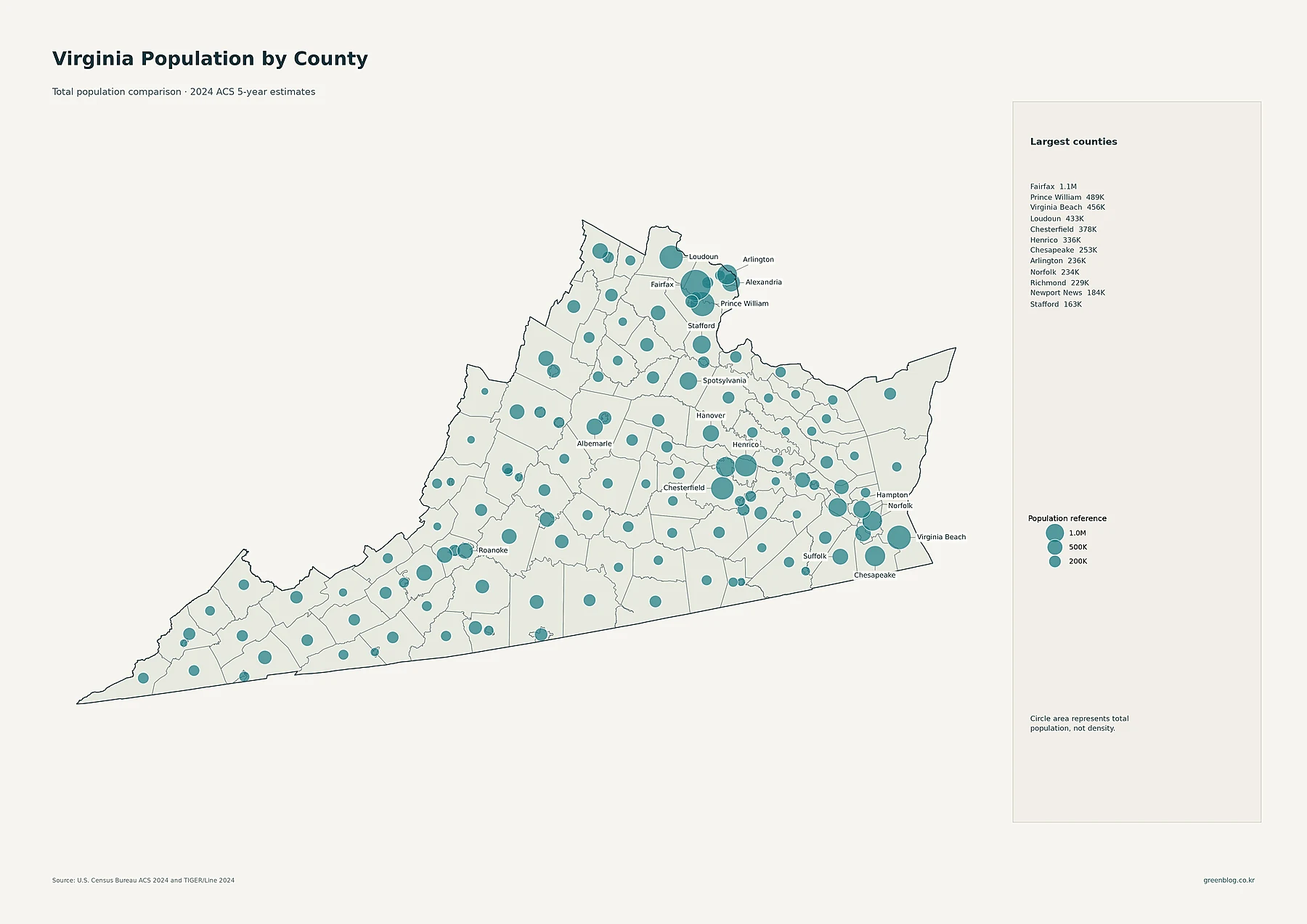
Fairfax County has 1,147,837 residents, by far the largest county-equivalent population in the supplied data. Prince William County has 488,880, Virginia Beach 456,349, and Loudoun County 432,998. Chesterfield County has 377,869 residents, Henrico 335,744, Chesapeake 252,583, Arlington County 236,254, Norfolk 233,596, and Richmond 229,359.
Newport News has 184,216 residents, Stafford County 163,466, Alexandria 156,976, Spotsylvania County 146,603, and Hampton 137,557. The map therefore shows three especially strong population regions: Northern Virginia, the Richmond area, and Hampton Roads. Large portions of western and southwestern Virginia have much smaller county totals.
Virginia’s independent-city system requires careful reading. Fairfax County and the independent city of Fairfax, for example, are separate county-equivalent units. Fairfax County has more than 1.1 million residents, while Fairfax city has about 25,000. The map groups both types of jurisdictions at the same administrative level, so naming the correct unit matters when comparing totals or density.
Alexandria and Arlington lead county-equivalent density by a wide margin
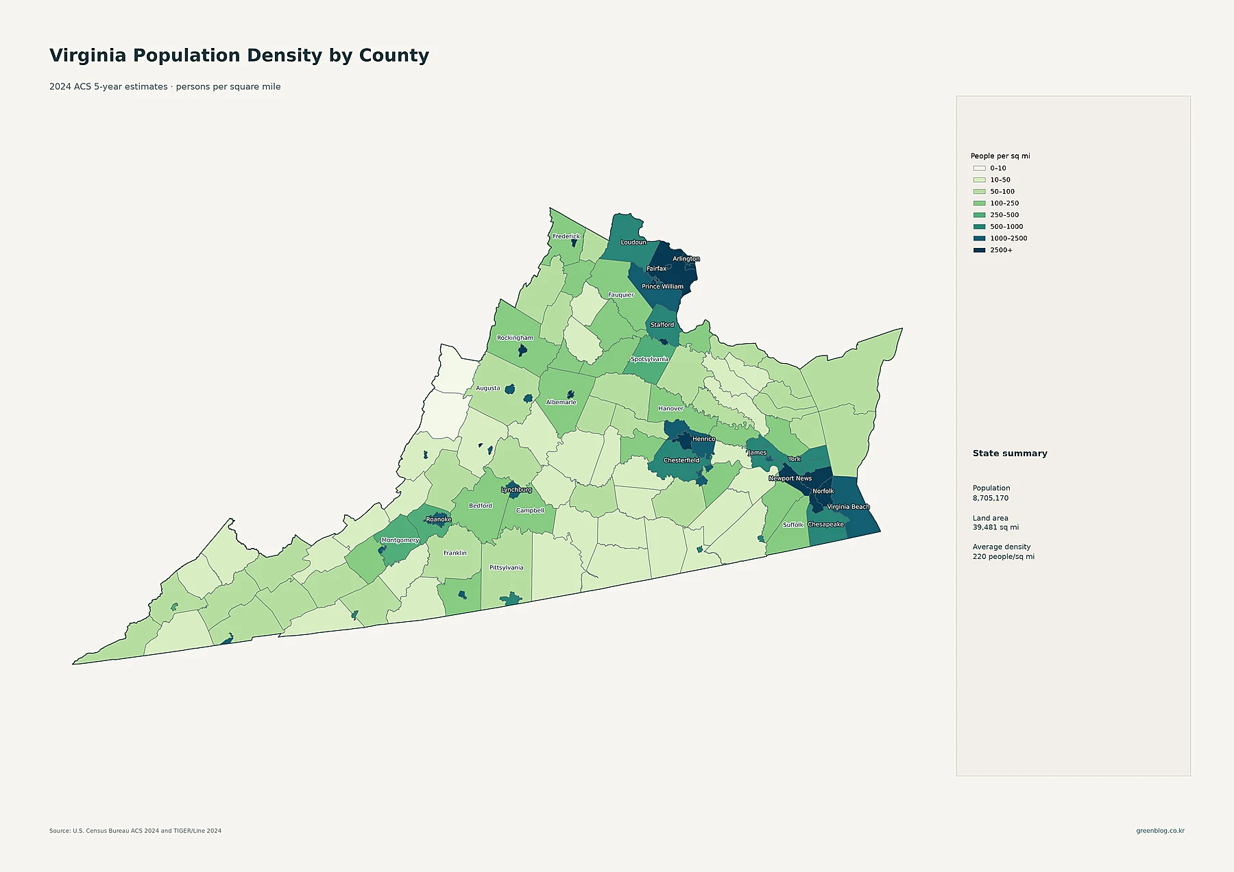
Alexandria has the highest county-equivalent density at about 10,510.4 people per square mile. Arlington County follows at about 9,087.6. Falls Church is about 7,188.1, Manassas Park 5,536.9, Charlottesville 4,434.9, Norfolk 4,384.7, and Manassas 4,366.1. The independent city of Fairfax averages about 4,010.0, while Richmond is about 3,827.4 people per square mile.
Fairfax County itself remains very dense at about 2,935.5 people per square mile. Portsmouth averages about 2,918.6, Fredericksburg 2,762.9, Hampton 2,673.0, Newport News 2,670.0, and Roanoke 2,313.1. Virginia Beach averages about 1,864.8, Prince William County 1,458.2, and Henrico County 1,436.7. The darkest areas on the county-density map therefore cluster around Washington, Hampton Roads, and Richmond.
Much of western and southwestern Virginia is far less dense. The statewide average of about 220 people per square mile combines compact independent cities and dense suburban counties with large mountain and rural counties. Because independent cities often cover small land areas, their density values can be much higher than neighboring counties even when their total populations are smaller.
| Measure | Leading area | Value in supplied data |
|---|---|---|
| State population | Virginia | 8,705,170 |
| Largest place population | Virginia Beach | 456,349 |
| Largest county-equivalent population | Fairfax County | 1,147,837 |
| Highest county-equivalent density | Alexandria | about 10,510.4/sq mi |
| Fastest 2010–2020 growth | Loudoun County | +34.8% |
| Largest 2010–2020 decline | Buchanan County | -15.5% |
Loudoun led 2010–2020 growth, while the strongest declines clustered in southwest Virginia
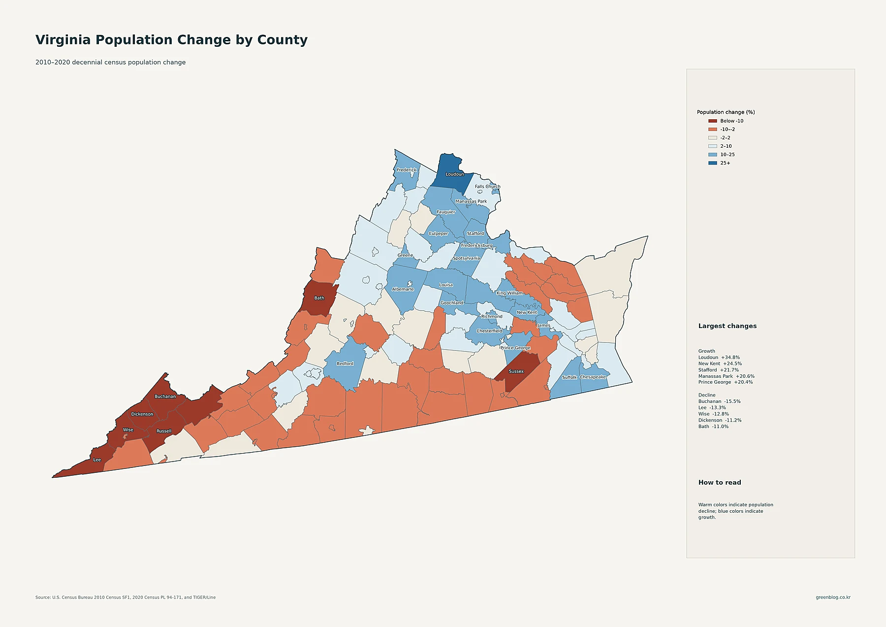
Loudoun County recorded the fastest percentage increase in the supplied decade data. Its population rose from 312,311 in 2010 to 420,959 in 2020, a gain of about 34.8%. New Kent County grew 24.5%, Stafford County 21.7%, Manassas Park 20.6%, and Prince George County 20.4%. Prince William County increased 20.0%, Falls Church 18.9%, James City County 16.8%, Frederick County 16.7%, and Bedford County 15.7%.
Northern Virginia contains the strongest concentration of growth. Loudoun, Prince William, Stafford, Arlington, Alexandria, and several independent cities all added population. The Fredericksburg–Stafford area also grew substantially. Around Richmond, Chesterfield County increased about 15.3%, while several neighboring jurisdictions also expanded. In Hampton Roads, growth was more mixed, with some jurisdictions adding population while others changed more slowly.
The strongest declines appear in southwestern Virginia. Buchanan County fell from 24,098 residents in 2010 to 20,355 in 2020, a decrease of about 15.5%. Lee County declined 13.3%, Wise County 12.8%, Dickenson County 11.2%, Bath County 11.0%, Russell County 10.8%, and Tazewell County 10.3%. Sussex County in the southeast interior also declined about 10.4%.
These percentages belong specifically to the 2010–2020 decennial-census period. They should not be described as changes in the 2024 ACS estimate. Fairfax County is the largest county today, while Loudoun was the fastest-growing county during the previous census decade. Current size and historical growth are different measurements.
Virginia combines a dense, fast-growing north with several major regional hubs and a shrinking southwest
The five maps make Northern Virginia the clearest current population core. Fairfax County has the largest county-equivalent population, Alexandria and Arlington lead density, and Loudoun County leads 2010–2020 growth. The tract map shows that these jurisdictions form one broad high-density settlement belt along the Washington metropolitan edge rather than a set of isolated places.
Hampton Roads forms another major system, with Virginia Beach as the largest census place and several large independent cities packed around the waterways of southeastern Virginia. Richmond, Henrico, and Chesterfield anchor central Virginia. Roanoke, Lynchburg, Harrisonburg, and Charlottesville serve as more isolated western and interior hubs. Southwestern counties, meanwhile, combine lower density with some of the state’s largest percentage declines.
Virginia’s independent-city structure makes careful map reading especially important. Place population, county-equivalent population, county-equivalent density, tract-level density, and historical population change should be kept separate. Used together, they show where Virginians live now, how tightly those settlements are packed, and how differently Northern Virginia and the southwest moved during the 2010s.
Download the Virginia population map collection
The ZIP includes detailed census-tract density, major cities and urban areas, county and independent-city population totals, 2010–2020 population change, and county-equivalent population density.
FAQ
Which Virginia county has the largest population?
Fairfax County is the largest in the supplied 2024 ACS 5-year estimates, with 1,147,837 residents. Prince William County has 488,880 and Loudoun County 432,998. Fairfax County also remains the largest when Virginia’s independent cities are included as county-equivalent units.
Which Virginia county-equivalent has the highest population density?
The independent city of Alexandria has the highest density at about 10,510.4 people per square mile. Arlington County is about 9,087.6 and Falls Church is about 7,188.1 people per square mile.
Which Virginia county grew fastest from 2010 to 2020?
Loudoun County grew about 34.8%, followed by New Kent County at 24.5% and Stafford County at 21.7%. Manassas Park, an independent city, grew about 20.6%. These percentages compare the 2010 and 2020 decennial censuses.
Related Maps
Sources
- U.S. Census Bureau — American Community Survey (ACS): 2024 5-year population and density estimates
- U.S. Census Bureau — TIGER/Line Shapefiles: 2024 state, county-equivalent, census tract, and census place boundaries
- U.S. Census Bureau — Decennial Census: 2010 and 2020 county-equivalent population comparison
Green Map creates custom-edited map images using open geographic data sources such as geoBoundaries, Natural Earth, OpenStreetMap, and government open data.
These maps are edited visual materials, not raw data files, and are provided for education, documents, presentations, and graphic reference.