Tioga County has a strongly rural land-cover pattern in 2025: forest occupies 57.02% of the county, agriculture 29.67%, developed land 9.60%, wetlands 2.16%, and water 0.78%. The broadest wooded areas are interrupted by farmed valleys and smaller settlement corridors, while the most conspicuous developed cluster appears around Owego and the Susquehanna River in the south. This page brings together four views of that landscape so the countywide percentages can be read alongside their actual locations.
The web page uses lightweight WebP previews, and the four original JPG maps are available together in one download. They cover current land cover, forest and farmland, impervious surface, and mapped class differences between 1985 and 2025. Land cover describes what physically covers the ground in the source classification; it does not establish ownership, zoning, parcel boundaries, or development rights.
Table of Contents
Tioga County’s 2025 land-cover pattern
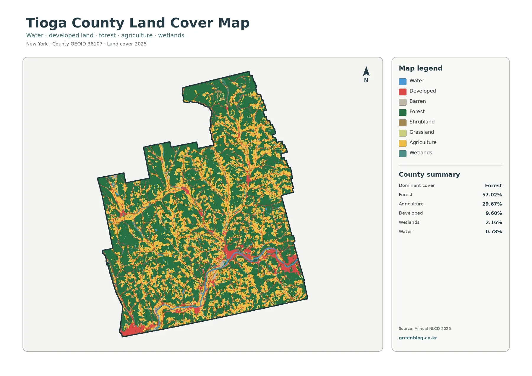
Dark green forest dominates the first impression, but the county is not one continuous block of woodland. Yellow agricultural cover repeatedly divides the green across the north, center, west, and south. Some farm areas form broad patches, while others follow narrow openings through wooded terrain. The 57.02% forest figure therefore works best as a county summary, not as a description of every local area.
Agriculture accounts for 29.67%, making it the second-largest mapped class. Its distribution is widespread enough that farm cover remains visible in nearly every large part of the county. The pattern is especially useful for understanding why a single countywide label such as “forested” would be incomplete: Tioga is also a substantial agricultural landscape, with many places where woods and farm cover meet at short distances.
Tioga County’s official Agricultural Development program provides useful local context. The county maintains three New York State agricultural districts that include towns such as Spencer, Candor, Barton, Tioga, Owego, Nichols, Newark Valley, Berkshire, and Richford. Those administrative districts are not the same thing as the yellow land-cover class. Still, they confirm that agriculture is an important countywide land context rather than an isolated feature.
Developed land is only 9.60% of the county, yet it stands out because it is concentrated. The largest red grouping sits in the southern part of the map around Owego and the Susquehanna River. Another developed concentration is visible toward the southwestern edge, and smaller clusters appear among the farm and forest areas farther north. Thin linear traces connect some of these places, giving the developed class a corridor-like appearance without filling the surrounding rural landscape.
Wetlands and water occupy much smaller shares, 2.16% and 0.78% respectively. Their value on the map is partly positional. Blue water and teal wetland cells provide recognizable reference features when moving from one map to another, and they reveal that the forest–farm pattern contains many smaller wet or open interruptions. These classes should not be mistaken for legal wetland boundaries, flood zones, or detailed hydrography.
The legend also includes barren, shrubland, and grassland categories. In the forest-and-farmland summary, grassland is 0.32% and shrubland 0.20%. Those small classes are difficult to evaluate at county scale unless the image is enlarged. A practical reading order is to establish the forest–agriculture balance first, then locate developed centers, wetlands and water, and only afterward examine the minor categories.
Where forest and farmland interlock
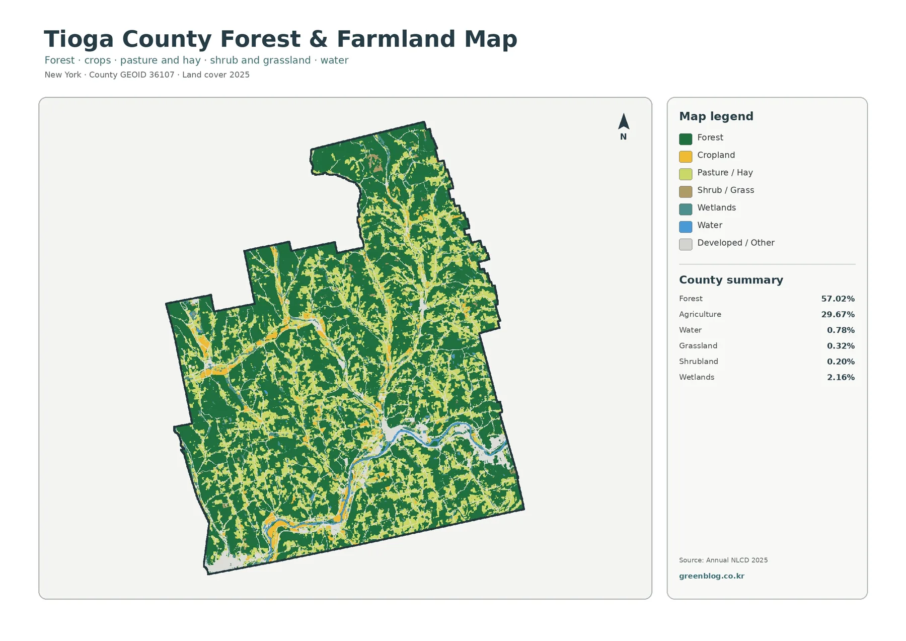
The forest-and-farmland map removes much of the visual competition from developed classes, so the rural structure becomes easier to follow. Wooded cover stays extensive in every direction, while cropland and pasture create a finer network of openings. The agricultural areas are not arranged as one broad plain. Instead, they appear in bands, pockets, and connected fields that repeatedly touch forest edges.
This view is particularly useful in the central and northern portions of the county, where agricultural colors occupy many narrow and medium-sized areas inside a larger wooded setting. In the south, farm cover remains important but is interrupted by the larger developed corridor and the river. Comparing these areas side by side helps explain why the county average can be mostly forest while many local views still feel strongly agricultural.
An agricultural cover cell is not a legal farm parcel. Raster classification divides the landscape into grid cells, and a working farm may contain several classes: cropland, pasture, woodland, buildings, water, or wetlands. Conversely, a continuous yellow patch can cross multiple properties. For farm planning, tax status, agricultural-district membership, or ownership, the appropriate parcel and county program records are needed in addition to this map.
The same caution applies to forest. Green indicates land classified as forest cover, but it does not identify tree species, stand age, timber history, public ownership, or conservation status. A large green area should not automatically be called a preserve or public forest. The map is strongest at showing the extent and arrangement of wooded surface, while management questions require forestry or property-specific sources.
One useful comparison exercise is to choose a farm-rich area and trace its edges. Note where forest becomes continuous, where wetlands or small water patches appear, and where the light “developed/other” class cuts through the rural pattern. Then locate the same place on the impervious and change maps. That sequence reveals whether a visually busy rural area actually contains much hard surface and whether the 1985–2025 endpoint comparison marks a class difference there.
Owego, the Susquehanna, and the southern developed cluster
The southern part of Tioga County provides the clearest anchor for reading the maps. County recovery documents describe the Village of Owego as being divided by the Susquehanna River, which flows east to west through the community. On the land-cover map, this same area contains the county’s most prominent developed concentration, set against nearby farm and forest cover.
That spatial coincidence should not be turned into a simple cause-and-effect statement. The map can establish that development, transportation-like linear features, and the river occur near one another, but it cannot prove why growth took place there. Historical settlement, roads, topography, floodplain conditions, economics, and planning decisions all require separate evidence. The land-cover image is a location reference, not a history of development.
Smaller developed nodes occur away from Owego as well. Northward through the county, red patches appear within agricultural openings and along thin lines that cross wooded areas. A southwestern cluster is also easy to recognize. Taken together, these places explain why 9.60% developed cover can have a visible presence on the map even though more than four-fifths of the county is mapped as forest or agriculture.
Water provides a second orientation clue. The broad southern river feature is easy to locate on all four maps, while smaller water bodies and wetland patches are more scattered. Blue cells indicate surface water in the classification; they do not report depth, water quality, flood probability, or public access. A hydrography or flood map is the better source when the river itself is the main subject.
Wetland colors deserve similar restraint. Annual NLCD wetland classes are remote-sensing categories at raster scale, not regulatory wetland delineations. They are useful for a county overview and for comparing wet areas with forest, agriculture, and development. A permit, property decision, drainage project, or legal determination requires the latest agency information and, when appropriate, field review.
What the 2025 impervious map adds
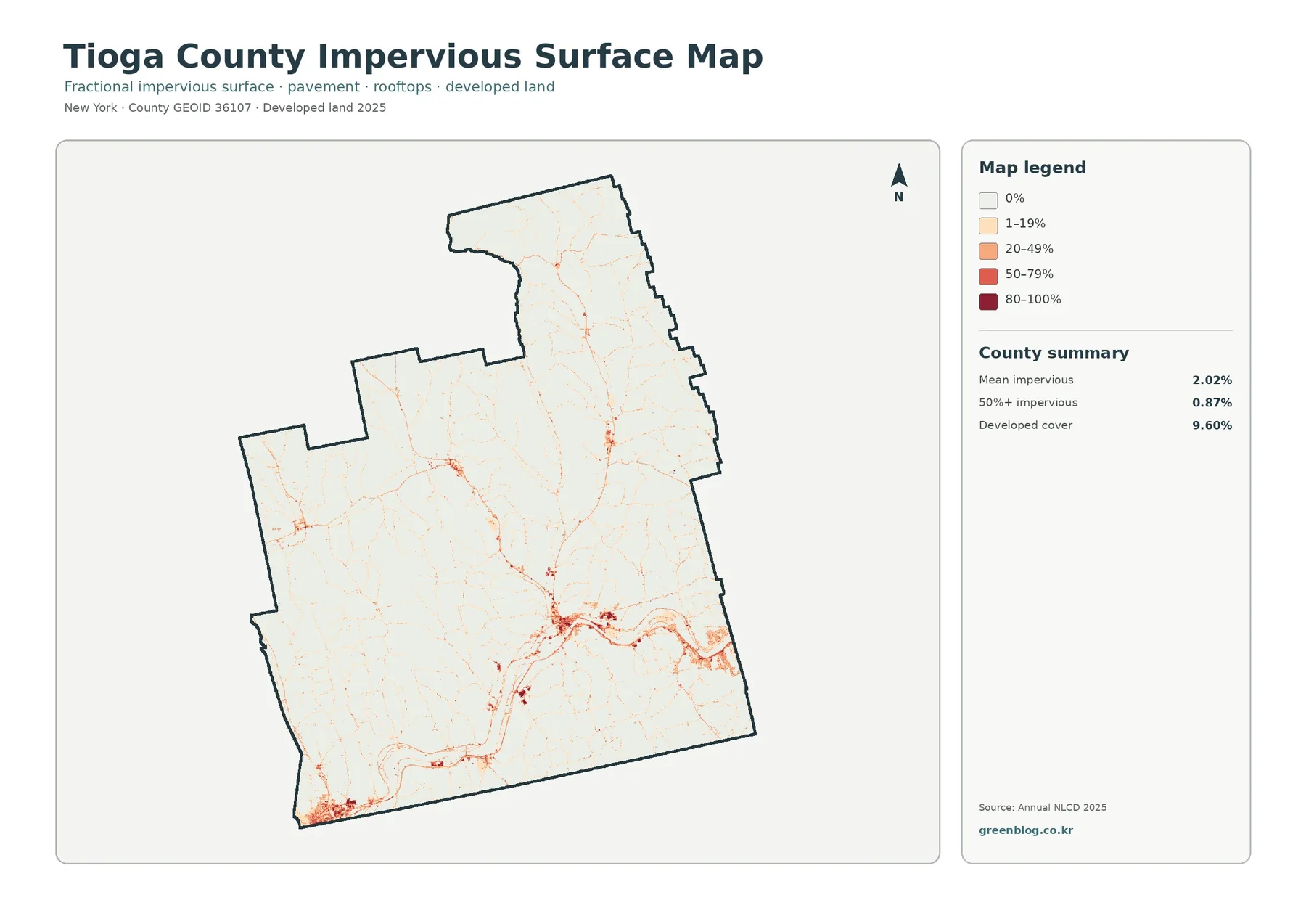
Impervious surface means ground such as pavement, parking areas, and rooftops where water does not readily soak into soil. Tioga County’s mean impervious value is 2.02%, and cells with at least 50% impervious cover account for 0.87% of the county. These figures are deliberately different from the 9.60% developed-cover share because a developed land-cover class can still contain lawns, trees, bare soil, and other permeable surfaces.
Most of the impervious map is pale, reflecting the large area occupied by forest and agriculture. The strongest oranges and reds cluster around Owego and the southern river corridor. Higher values also appear in the southwestern developed area and in several smaller settlement nodes. Thin lines extend between some clusters, but the map does not provide road names, traffic volume, lane count, or pavement condition.
A county mean of 2.02% can hide these local peaks. Averaging the developed centers together with extensive low-impervious forest and farmland produces a small overall number. Looking at the map alongside the mean prevents two opposite errors: assuming that Tioga is broadly paved because the red clusters are visually strong, or assuming that dense hard-surface areas are unimportant because the county average is low.
The 0.87% figure for cells at or above 50% impervious cover should also be read carefully. It is not saying that 0.87% of the county is a single solid slab of pavement. Rather, it identifies the share of mapped cells in which hard surfaces occupy at least half of the cell. That measure is useful for comparing development intensity within the broader developed land-cover class.
Impervious cover is often relevant to stormwater studies, but this map alone cannot calculate runoff, flooding, or water quality. Slope, soils, drainage infrastructure, rainfall, vegetation, and distance to streams all influence what happens after rain falls. For planning or environmental education, the map is a good first layer for locating concentrations of hard surface; detailed risk work needs additional hydrologic information.
Reading the 1985–2025 class-difference map
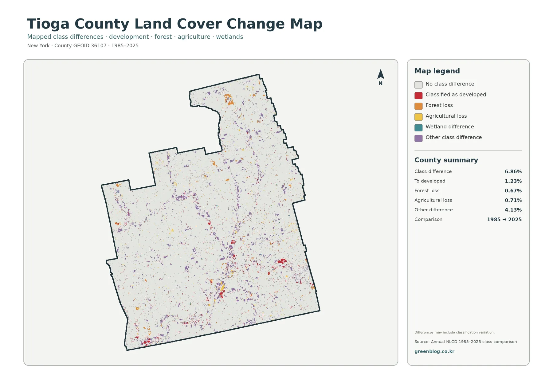
The endpoint comparison marks 6.86% of Tioga County as having a different land-cover class in 2025 than in 1985. The summary panel separates part of that total into 1.23% classified to developed, 0.67% forest loss, 0.71% agricultural loss, and 4.13% other class difference. Wetland difference has its own legend category, but the supplied summary does not assign it a separate percentage.
Other class difference is the largest named component at 4.13%. Purple marks are scattered across the county, including many places where agriculture and forest are interwoven. That distribution is a reminder that the 6.86% total is not a development statistic. It combines several kinds of endpoint differences, and the source map itself notes that classification variation may contribute to the result.
Red cells classified to developed are more noticeable around some settlement and corridor areas, including parts of the south. Even so, the 1.23% value cannot be treated as a complete history of all development since 1985. The current land-cover map asks what is present in 2025; the change map asks whether the endpoint classifications differ. Those are related but not interchangeable questions.
Forest-loss and agricultural-loss colors occur as smaller pieces rather than one sweeping band. A colored cell does not reveal the reason for the difference. Timber harvest, construction, field conversion, natural disturbance, succession, or classification behavior could require separate evidence. Intermediate Annual NLCD years, aerial imagery, local records, and site observations are more appropriate when the goal is to reconstruct a specific sequence of events.
Endpoint maps also miss temporary changes that return to the original class. If a cell changed in the 1990s and later returned to its 1985 class by 2025, the start and end may look unchanged. Conversely, small shifts along boundaries can produce a mapped difference even where the real-world transition is subtle. For trend analysis, a time series is more informative than a two-date comparison alone.
A simple four-map comparison workflow
Begin with one recognizable location rather than scanning all four images at once. Owego works well because the developed cluster and the Susquehanna River make it easy to relocate. Identify the current cover on the general map, check the surrounding forest–farm balance, compare hard-surface intensity on the impervious map, and then see whether the endpoint comparison marks a class difference in the same area.
A rural example gives a different lesson. Choose a farm-rich patch in the central or northern county and note how much woodland surrounds it. Look for small wetlands, water, and light developed/other surfaces nearby. On the impervious map, many such places remain pale even though the land-cover image is visually complex. The comparison separates landscape diversity from hard-surface intensity.
Wooded areas are also worth tracing at their edges. A continuous green interior may transition quickly into fields, a small settlement, or wet cover. On the change map, inspect the legend before interpreting any colored patch: orange forest loss means something different from purple other difference. This discipline keeps a broad “change” label from swallowing several distinct categories.
County-to-county comparisons require matching measures. Tioga’s 57.02% forest can reasonably be compared with another county’s forest share from the same land-cover year. It should not be compared directly with that county’s impervious mean or a different-year estimate. Change comparisons also need the same endpoints and compatible classification methods.
For classroom use, turn the map set into four questions: What covers the ground now? How are woods and agriculture arranged? Where are hard surfaces concentrated? Which cells differ between the two endpoint years? Students can answer those questions from the images without being asked to infer ownership, zoning, crop productivity, or causes that the maps do not contain.
Download the four original JPG maps
The download package contains four separate JPG files: 2025 land cover, forest and farmland, impervious/developed surfaces, and the 1985–2025 land-cover class-difference map. Each image includes its own title, legend, and county summary. The files are convenient for printing, classroom handouts, reports, presentation slides, and visual comparisons with other county maps.
Choose the general land-cover map for a broad county overview. The forest/farmland version is clearer when the main subject is the rural balance between woods and agriculture. Use the impervious map to discuss concentrations of pavement and rooftops, and use the class-difference map only when the question explicitly involves the 1985 and 2025 endpoints. Matching the map to the question keeps captions and explanations straightforward.
Keep the map title, legend, and year visible when an image is cropped for a slide. Red has a different meaning in three of the maps: developed land, higher impervious percentage, and classification to developed. Without the legend, those categories can easily be confused after the graphic has been separated from the page. A short caption naming both the theme and year is usually enough to preserve context.
The package preserves the supplied original JPG dimensions rather than claiming a print standard that the source does not guarantee. Before making a large print, open the downloaded image at the intended size and check whether the legend remains readable. The WebP previews are meant for quick browsing; decisions about print clarity should be made from the JPG files themselves.
Limits to keep in mind
Annual NLCD is raster data, so the landscape is represented by a grid of cells rather than surveyed parcel polygons. Along a forest edge, narrow road, field boundary, small wetland, or stream, one cell can contain more than one real surface. The classification generalizes those mixed conditions, which is why a colored edge should not be treated as an exact property or regulatory boundary.
Countywide percentages are summaries rather than local guarantees. A 57.02% forest share does not mean every town is about 57% forest, and 29.67% agriculture does not mean farms are evenly spread. The maps clearly show internal contrasts: large wooded areas, farm-rich openings, the southern developed center, and smaller settlement nodes. Use the percentages for overall scale and the colors for location.
The current maps represent the 2025 classification. Conditions after that observation year may differ because of crop rotation, timber activity, construction, road work, vegetation change, or shifts along wetland and stream edges. A current parcel question should be checked against recent aerial imagery, county GIS, field observations, and the appropriate local or state records.
None of the four maps establishes zoning, agricultural-district status, ownership, conservation restrictions, tax parcels, or legal development potential. County agricultural and natural-resource pages are helpful companion sources, but they answer different questions. Land cover is best used for county-scale orientation, education, comparison, and deciding where more detailed research should begin.
The 1985–2025 comparison needs extra caution because the 6.86% total includes several class-difference categories and the largest named portion is “other difference.” It would be inaccurate to describe the entire value as urban growth, deforestation, or farmland loss. A defensible explanation keeps the categories separate and uses additional evidence before assigning a cause.
Frequently Asked Questions
What is the largest land-cover class in Tioga County in 2025?
Forest is the largest at 57.02%, followed by agriculture at 29.67%. Developed land is 9.60%, wetlands 2.16%, and water 0.78%. The distribution is not uniform, so the county totals should be read with the map: wooded areas are extensive, agriculture is widespread, and the strongest developed cluster is in the south around Owego.
Why is developed cover 9.60% while mean impervious cover is only 2.02%?
They measure different things. Developed land is a broad landscape classification, while impervious percentage measures hard surfaces such as pavement and rooftops within each cell. A developed area may also contain lawns, trees, soil, and other permeable cover. In Tioga County, cells at or above 50% impervious cover account for 0.87% of the county.
Does the 6.86% class difference mean 6.86% of Tioga County was developed?
No. The total includes 1.23% classified to developed, 0.67% forest loss, 0.71% agricultural loss, 4.13% other class difference, and the separately mapped wetland-difference category. The comparison also can include classification variation. Determining why a particular place changed requires intermediate-year data, imagery, or local records.
Map File Information
The ZIP contains four original Tioga County JPG maps covering 2025 land cover, forest and farmland, impervious/developed surfaces, and mapped class differences from 1985 to 2025.
- Included Files: Tioga County land cover, rural cover, impervious surface, and 1985–2025 class-difference maps
- File Type: One ZIP with four separate original Tioga County JPGs
- Intended Use: Print reference, lessons, slide decks, environmental comparisons, and map review
Related Maps
- Albany County Land Cover Map
- Allegany County New York Land Cover Map
- Bronx County New York Land Cover Map
Sources and reference materials
The percentages on this page come from the supplied Annual NLCD-based county map summaries. Official Tioga County pages were used for agricultural-district, natural-resource, and Owego-area context.
- MRLC Annual NLCD Data – data access and product information
- USGS Annual NLCD Land Cover Classification – explanation of land-cover classes
- U.S. Census Bureau TIGER/Line Shapefiles – county boundary reference data
- Tioga County Agricultural Development – official agricultural-district and farmland information
- Tioga County Soil and Water Conservation District – county soil, water, and natural-resource programs
- Village of Owego Long Term Community Recovery Strategy – official geographic context for Owego and the Susquehanna River
Land cover, agricultural districts, planning data, and water-resource records serve different purposes. Use the map set to understand broad surface patterns, then move to the appropriate official GIS, parcel, environmental, or planning source when a decision depends on a precise boundary or current site condition.
Green Map creates custom-edited map images using open geographic data sources such as geoBoundaries, Natural Earth, OpenStreetMap, and government open data.
These maps are edited visual materials, not raw data files, and are provided for education, documents, presentations, and graphic reference.