The Romania Map collection is built around a useful contrast: the country has a continuous, easily recognized outer shape, but its interior is divided into a dense network of counties. That combination makes a county map valuable for more than memorizing names. It helps readers compare the central, western, southern, and eastern parts of Romania through the administrative pattern visible on the page.
Romania lies in southeastern Europe, bordered by Hungary and Serbia to the west, Bulgaria to the south, Ukraine to the north and east, and Moldova to the east. The country reaches the Black Sea in the southeast, while the Danube follows much of the Bulgarian border before entering the Danube Delta. Neither the surrounding countries nor the Black Sea, Danube, mountains, or delta is drawn or labeled in the supplied files; they are geographic context rather than visible map layers.
Three map versions are included: an unlabeled outline, a labeled black-and-white map, and a color-coded county map. The published WEBP previews measure 1200 × 849 pixels. The original download information supplied with the page identifies 4960 × 3510-pixel JPG files prepared in CMYK for A3 output. The Romania Map files serve classroom handouts, country profiles, presentation slides, labeling exercises, document graphics, and reader-created regional data displays.
Table of Contents
How to Read a Romania Map beyond the National Outline
The Carpathians form a broad arc through central and northern Romania. Inside that arc lies much of Transylvania, while Wallachia extends across the south and Moldavia occupies the east. Banat and Crișana provide additional historical and geographic orientation in the west. The mountains and historical regions are not drawn on the supplied maps, so their positions or boundaries should not be inferred from the county colors.
County placement nevertheless reflects the country’s varied regional form. Cluj, Alba, Mureș, Sibiu, Brașov, Harghita, and Covasna help define the central part of the page. Dolj, Olt, Teleorman, Giurgiu, Călărași, and Constanța create a long southern sequence. Tulcea occupies the eastern projection, while Timiș and Arad anchor the western side. The image stops at Romania’s national outline and provides no surrounding geographic background.
Bucharest is located in the southeast, within the wider area associated with Ilfov County and north of the Danube border. Because the capital sits among several compact counties, it normally needs careful treatment on a national administrative map. The supplied previews label Ilfov but do not provide a separate Bucharest label or clearly isolated capital polygon, a limitation explained in more detail below.
Country and File Information
| Item | Confirmed Information |
|---|---|
| Official name | Romania |
| Capital | Bucharest |
| Geographic area | 238,398 square kilometers |
| Population | 19,036,031, using 2025 EU figures |
| Administrative system | 41 counties plus the Municipality of Bucharest |
| Currency | Romanian leu, RON |
| Supplied versions | Outline, labeled black-and-white, and color |
| Published previews | 1200 × 849-pixel WEBP images |
| Original file information | 4960 × 3510-pixel CMYK JPG files, prepared for A3 output |
The 2025 area and population figures come from the European Union’s Romania country profile. Population values are date-sensitive, so the reference year should remain attached when the number is reused. The same source confirms the 41-county structure and the separate Municipality of Bucharest.
Counties, Ilfov, and the Bucharest Distinction
Romania’s first-level system consists of 41 counties, called județe in Romanian, plus Bucharest municipality, which has county-equivalent status. A complete administrative reference therefore describes 42 top-level units. County names such as Bistrița-Năsăud, Caraș-Severin, Dâmbovița, Maramureș, and Vâlcea retain Romanian diacritical marks in the labeled files, which helps readers match them with current Romanian-language references.
The supplied Romania Map images visibly divide and, in the labeled versions, name the 41 counties. They do not separately label Bucharest or show it as an unmistakable independent unit inside Ilfov. The collection is therefore best described as a 41-county map set, with Bucharest’s county-equivalent status explained separately, rather than as a visible 42-unit map.
Ilfov is the small county shown between Dâmbovița, Prahova, Ialomița, Călărași, and Giurgiu. In Romania’s actual administrative structure, it surrounds Bucharest. Readers preparing a capital-location exercise can add a Bucharest marker to the outline, but a project requiring the exact municipal boundary should use a dedicated Bucharest–Ilfov reference rather than infer it from this national preview.
Romania Outline Map for Labeling and Custom Data
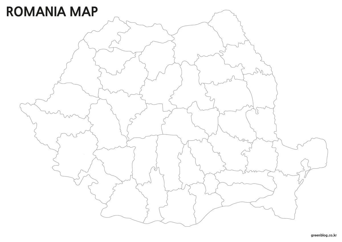
The first Romania Map removes all county names and fills while preserving the national edge and internal lines. Romania has no detached island territories in this layout, so every county remains part of one connected mainland figure. The southeastern boundary around Constanța and Tulcea remains recognizable, but no sea area, delta, river, or neighboring territory is shown.
This edition provides the most room for reader-added information. Students can label counties, identify Bucharest separately, or group counties into broader historical regions. Designers can apply verified population, tourism, agriculture, election, or transport categories without having to cover existing labels. The file is a raster image rather than a confirmed vector source.
Labeled Black-and-White Romania County Map
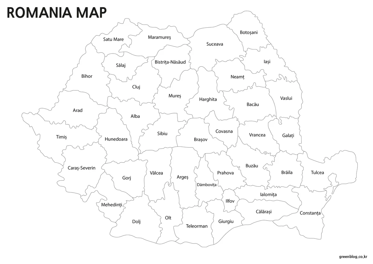
The labeled black-and-white Romania Map gives priority to county spelling and position. Central counties such as Sibiu, Brașov, Mureș, and Covasna can be compared with the wider eastern and southern units, while long names such as Bistrița-Năsăud and Caraș-Severin remain contained within their regions. Removing colored fills reduces visual competition in worksheets and document inserts.
This version is the natural reference or answer key for an outline-based activity. It can also support a lesson that follows counties from Timiș in the west to Constanța and Tulcea in the east. Since surrounding countries, seas, mountain symbols, rivers, roads, and city points are absent, it should be paired with another reference when those features are part of the task.
Color-Coded Romania County Map
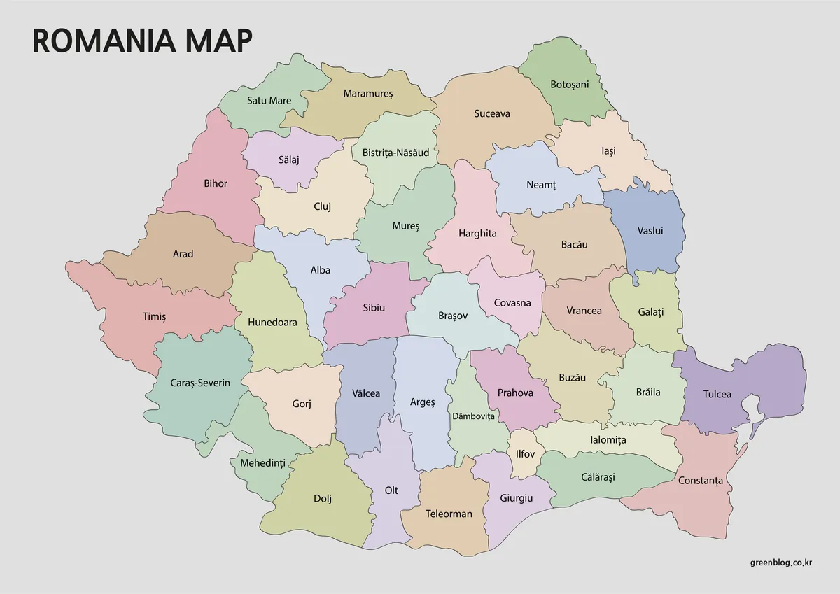
The color Romania Map uses muted contrasting fills to separate adjacent counties. Color is especially effective in the center, where Alba, Sibiu, Mureș, Harghita, Covasna, and Brașov meet within a relatively compact area. It also makes the southern progression from Dolj through Olt, Teleorman, Giurgiu, Călărași, and Constanța easier to follow.
Labels remain more prominent than the fills, allowing the image to function as a reference rather than a decorative patchwork. This edition is suited to presentation screens, country-comparison pages, and introductory slides where the internal structure must be understood quickly. Its colors identify counties only; they do not represent elevation, historical regions, climate, population, or political categories.
Choosing the Right File for Print or Screen
Choose the labeled Romania Map when the names must be available immediately and the image will appear in a report, study guide, or answer sheet. Select the color version when adjacency and the density of the county network matter more than writing space. Use the outline when the reader will provide labels, routes, regional groups, or statistical colors.
The original 4960 × 3510-pixel layout has the proportions of an A3 landscape page. It can be reduced for A4 output, but the longest county names and the small Ilfov area should be checked in print preview before producing multiple copies. The 1200 × 849 WEBP images displayed on the page are convenient for quick viewing, while the original JPG files are the appropriate choice for full-size printing.
CMYK preparation supports a print-oriented workflow, although final color can still vary with the printer, paper, and software settings. The black-and-white file avoids reliance on county fill colors, making it the safer selection when a monochrome result is required.
Practical Uses Tied to Romania’s Geography
A European geography lesson can use the Romania Map to compare counties along Romania’s western, southern, northern, and eastern sides. A separate European locator map is needed to identify the neighboring countries and the Black Sea because they are not shown here. Students can add the Carpathian arc or the course of the Danube to the blank version, clearly treating those additions as outside geographic information rather than existing map content.
For a country presentation, the color map can introduce the 41-county pattern before separate slides examine Transylvania, Wallachia, Moldavia, the Danube Delta, or the Bucharest metropolitan area. A travel-planning graphic might mark a route from Bucharest toward Brașov and central Transylvania or east toward Constanța, but the map itself should not be treated as a road-navigation resource.
The files also provide a base for verified county-level statistics. Values can be added to the outline for population comparisons, regional tourism, agriculture, or other themes. Because Bucharest has county-equivalent status but is not separately drawn in the preview, datasets containing a Bucharest value require a distinct capital marker, inset, or corrected boundary source.
Frequently Asked Questions
How many administrative units does Romania have?
Romania has 41 counties and the Municipality of Bucharest, which holds county-equivalent status. That creates 42 top-level administrative units. The supplied maps label the 41 counties, while Bucharest is not separately labeled or clearly isolated as its own polygon in these previews.
Does the Romania Map show the Black Sea, Carpathians, or Danube?
No. The files show only Romania’s national outline and county boundaries. The Black Sea area, surrounding countries, Carpathian relief, Danube River, roads, cities, and tourist sites are not drawn or labeled. Those subjects require a separate location, physical, hydrographic, or transport map.
Which version is best for a county-labeling exercise?
Use the outline as the student worksheet and the black-and-white labeled file as the reference. The color map is better for introducing county adjacency before the exercise begins. Add a separate Bucharest point or inset if the assignment needs all county-level units represented.
Can the files be printed on A4 paper?
Yes. The originals were prepared for A3 landscape output and can be scaled down to A4. Before printing, check Bistrița-Năsăud, Caraș-Severin, Dâmbovița, and the compact Ilfov area at the selected size, because long names and small shapes lose clarity first.
Are these editable vector maps?
No vector source is confirmed. The download information identifies high-resolution CMYK JPG images, while the page previews are WEBP files. Raster images can be annotated in compatible image, presentation, or document software, but they should not be advertised as SVG, AI, or other vector files.
Map File Information
This collection provides three Romania county map images for full-size printing, county reference, classroom activities, presentations, and custom data graphics.
- Included Versions: Outline map, labeled black-and-white map, and color county map
- Original Image Size: 4960 × 3510 pixels
- Printable Size: A3 landscape
- File Type: JPG images
- Color Mode: CMYK
- Visible Administrative Scope: 41 labeled counties; Bucharest is not separately labeled in the preview
- Intended Use: Printed references, study sheets, presentation graphics, document images, and county-level data projects
Related Maps
- Moldova Map with Administrative Divisions
- Bulgaria Map with Labeled and Outline Versions
- Ukraine Map for Eastern European Reference
- Serbia Map with Administrative Regions
Additional Resources
- European Union: Romania Country Profile: Review Romania’s 2025 area and population figures, capital, currency, political system, and official administrative structure.
Green Map creates custom-edited map images using open geographic data sources such as geoBoundaries, Natural Earth, OpenStreetMap, and government open data.
These maps are edited visual materials, not raw data files, and are provided for education, documents, presentations, and graphic reference.