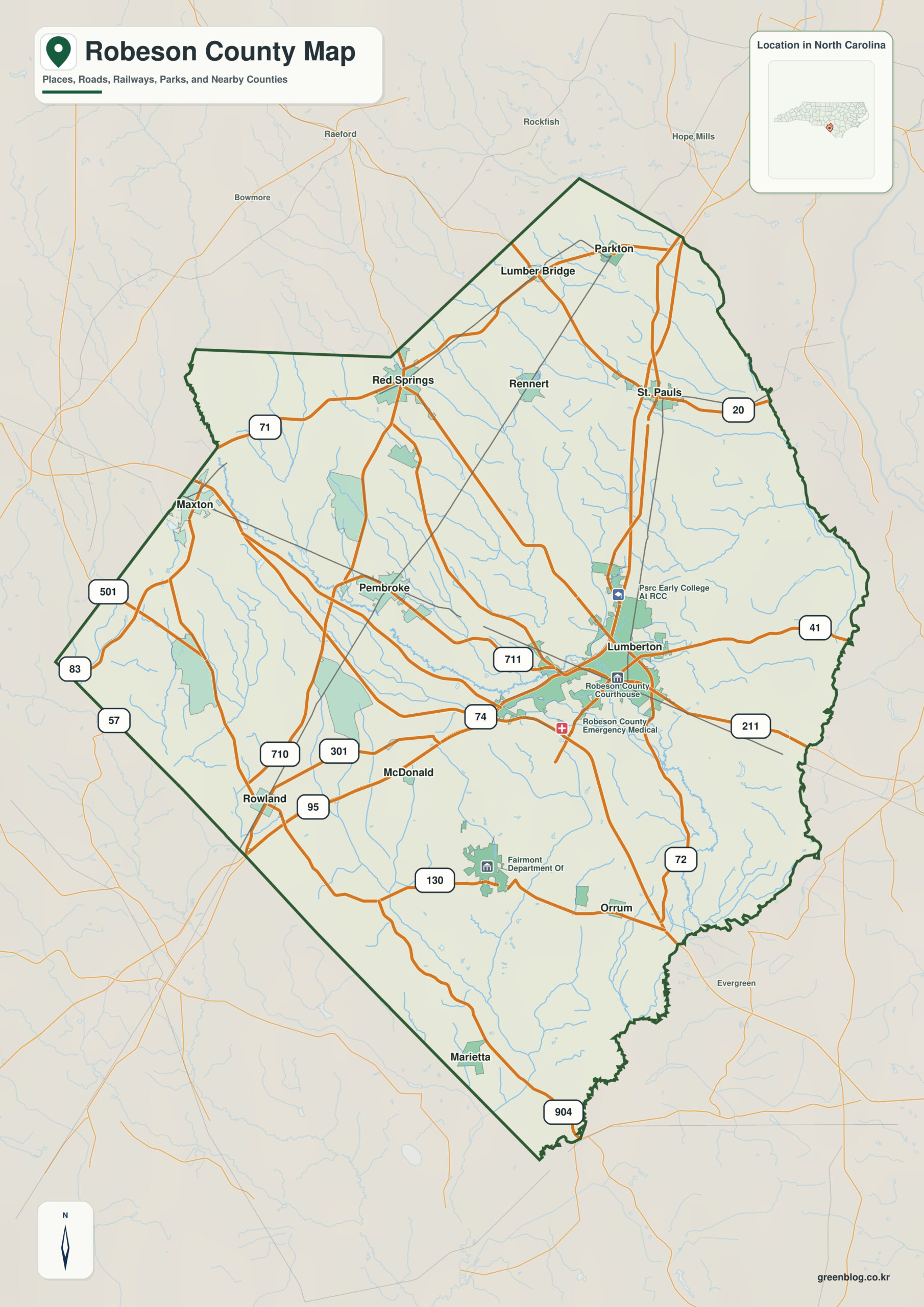
Robeson County North Carolina map is too large and culturally varied for a Lumberton-only reading. Pembroke’s university and Lumbee role, Red Springs in the northwest, and the Lumber River lowlands each deserve independent geographic weight.
Lumberton is a starting point, not a complete description of the county. Pembroke, Red Springs, Lumber River, and Coastal Plain / Sandhills transition reveal additional settlement and landscape zones that would otherwise disappear.
Robeson County quick facts
- County seat: Lumberton
- North Carolina setting: southern Coastal Plain / Sandhills edge
- Place references: Lumberton, Pembroke, Red Springs
- Physical references: Lumber River, Coastal Plain / Sandhills transition, Lumbee cultural landscape
- Neighboring counties: Bladen, Columbus, Cumberland, Hoke, Scotland
Lumberton and Pembroke serve different centers
Lumberton is the county seat, Pembroke is a western university and Lumbee cultural center, and Red Springs anchors a separate northwestern small-town area.
Lumber River and the Sandhills transition
The Lumber River passes through Lumberton and continues southeast through broad lowlands and swampy floodplain. The northwest toward Hoke and Scotland shows more Sandhills transition.
Lumbee cultural geography across a large county
Robeson is one of North Carolina’s larger counties and contains the cultural and educational center of the Lumbee community. Lumberton, Pembroke, and the Lumber River are all necessary to understand its geography.
This county is clearer when settlement references (Lumberton, Pembroke, Red Springs) and physical references (Lumber River, Coastal Plain / Sandhills transition) remain separate. The distinction improves both geographic interpretation and later use of demographic, transport, or recreation layers.
Using several anchors in a very large county
Do not merge Lumberton’s countywide administrative role with Pembroke’s university and Lumbee cultural role. Use the Lumber River as a natural axis and Red Springs as a northwestern reference so regional differences remain visible across this very large county.
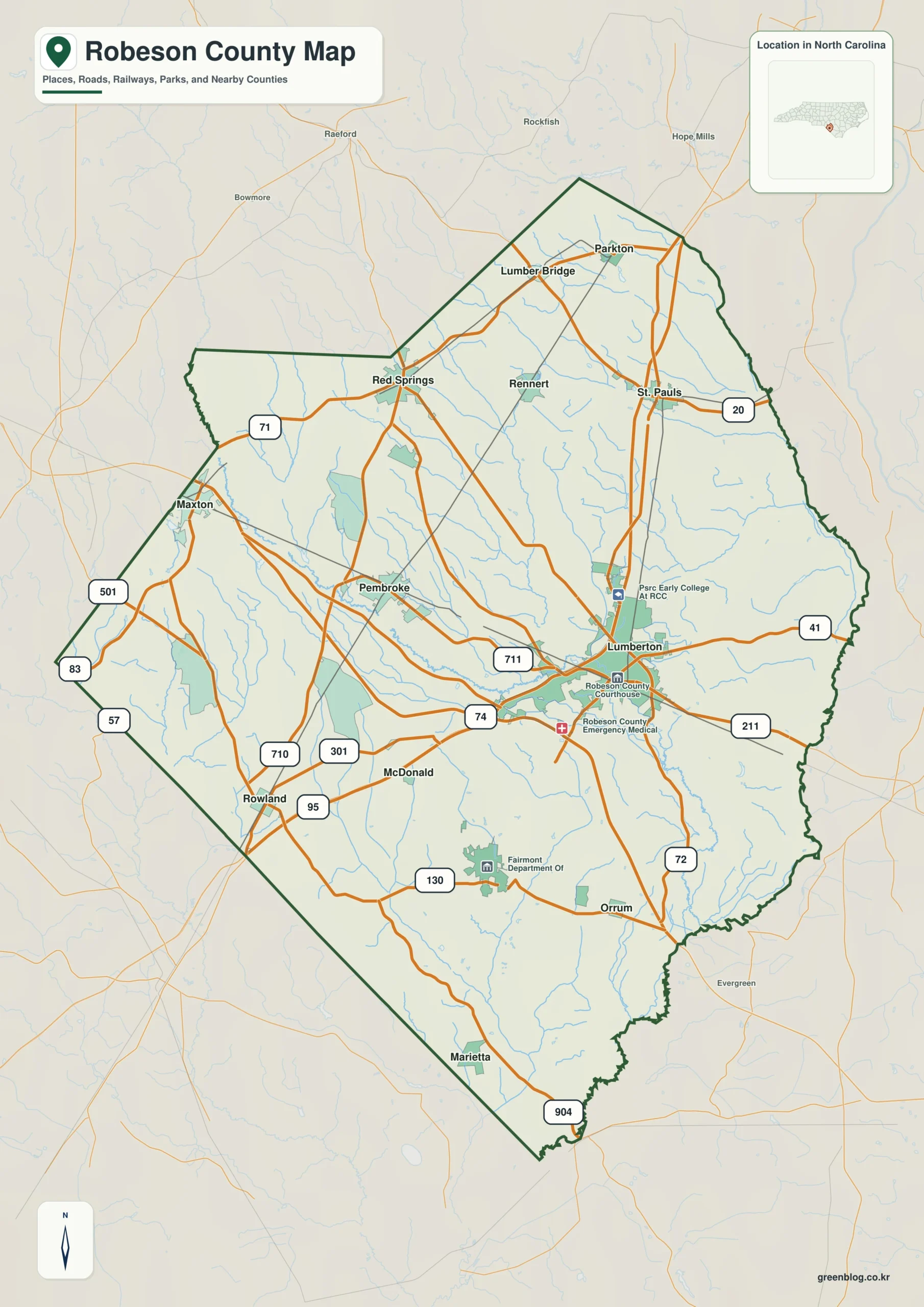
Robeson County single map file
The image above is a web preview; the button is reserved for the separate original map asset.
Download the Robeson County map fileFrequently Asked Questions
How does Lumber River help divide the county into meaningful geographic zones?
The value of Lumber River is that it explains physical orientation while the named communities explain settlement. Using both layers together produces a more accurate county-scale reading.
Why does Pembroke deserve its own map reference?
Lumberton and Pembroke do not need to have the same administrative status to be equally useful for orientation. One marks the seat; the other helps represent a different part of the county.
Sources
Related County Maps
Green Map creates custom-edited map images using open geographic data sources such as geoBoundaries, Natural Earth, OpenStreetMap, and government open data.
These maps are edited visual materials, not raw data files, and are provided for education, documents, presentations, and graphic reference.