Hall County sits in the southeastern Texas Panhandle, where Memphis, Turkey, Estelline, and Lakeview are separated by long stretches of open country rather than packed into one urban area. The maps on this page show how those communities relate to the road network, the Prairie Dog Town Fork Red River and its tributaries, and a noticeable drop in elevation from the higher western ground toward the central river valley. You can also download a ZIP containing high-resolution JPG versions of the county, city-connections, terrain-and-water, and elevation maps for printing or offline reference.
Table of Contents
Start with Memphis, then trace the county outward
Memphis is the clearest starting point because it is the county seat and appears near the northeastern part of Hall County on the city-connections map. Turkey lies far to the southwest, Estelline is east of the center and close to the eastern side, and Lakeview sits west-southwest of Memphis. That spread matters: the four labeled communities do not form a tight cluster, so a reader can quickly see why roads serving Memphis and Estelline do not describe every trip within the county.
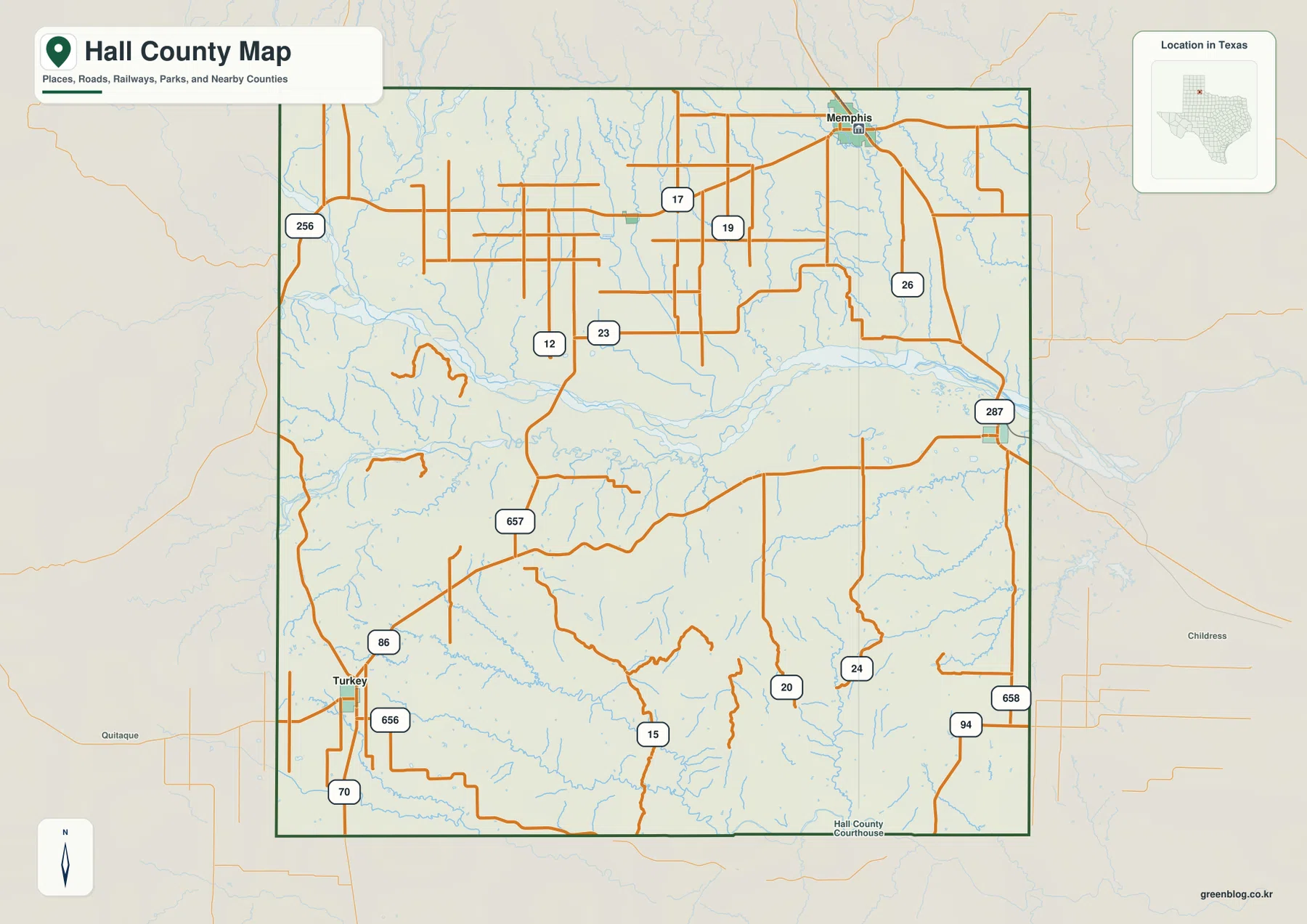
The county map also makes the road pattern easy to compare. The source material identifies U.S. 287 as the route serving Memphis and Estelline, while State Highway 86 reaches Turkey. Around Memphis and the northern half of the county, many numbered roads form a relatively dense grid. Farther south, the gaps between roads become larger and several routes bend around creek valleys instead of following the same rectangular pattern. Looking at roads this way is more useful than treating every route shield as an isolated label.
The edges of the map provide useful orientation beyond Hall County itself. Donley and Collingsworth counties appear to the north, Childress County is to the east, and Cottle, Motley, and Briscoe counties frame the southern and western sides. These surrounding names help when a route leaves the Hall County boundary, especially near Estelline on the east and Turkey in the southwest.
The distances between communities are part of the map story
The city-connections map ranks Memphis first and shows Turkey roughly 30 miles away, Estelline about 14 miles away, and Lakeview about 10 miles away. Those figures give a practical sense of scale. Memphis and Lakeview belong to the same northern portion of the county, yet they are still separated by open land and smaller roads. Estelline is much closer to the eastern edge, while Turkey occupies a distinct southwestern corner. A trip that starts in Memphis therefore changes character depending on whether it heads east toward Estelline or southwest toward Turkey.
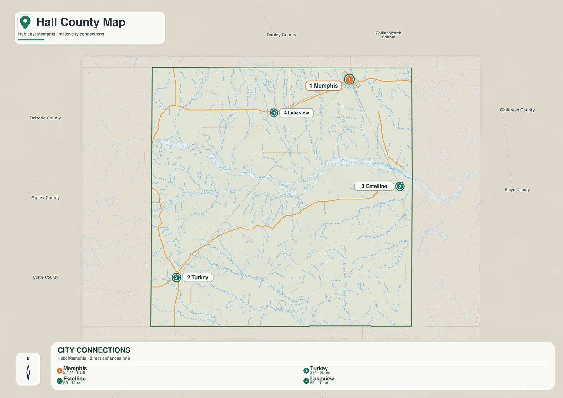
The map background changes across those directions as well. North of the main Red River fork, fine drainage lines run through broad uplands. Around Turkey and the southwest, the relief becomes visibly more cut by small valleys. Estelline sits on the eastern side of the county near the continuation of the main east-west drainage. The settlement map is therefore not just a city locator; it helps tie each community to a different part of the terrain.
Prairie Dog Town Fork Red River defines the middle of Hall County
The strongest water feature on the terrain-and-water map is the Prairie Dog Town Fork Red River, which crosses Hall County from west to east a little north of the geographic middle. Its broad valley creates a clear visual break between the northern uplands and the more dissected southern ground. On the west side, the Little Red River approaches the same central corridor. Farther north, Indian Creek and Johnson Creek descend toward the larger system, while Mountain Creek curves through the eastern half of the county.
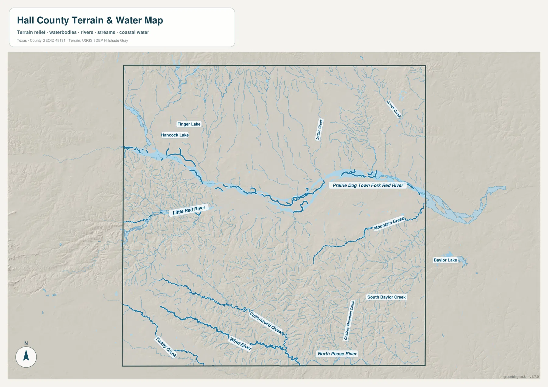
Several smaller named features make the southern half different from the north. North Pease River appears along the lower eastern edge, and Cottonwood Creek and Wind River run through the southern drainage network. Turkey Creek is labeled near the southwest, close to the town of Turkey. South Baylor Creek and Canyon Mountain Creek mark additional valleys toward the southeast. These names are useful when a reader needs a precise natural reference instead of relying only on road numbers.
The northwest also includes small water bodies labeled Finger Lake and Hancock Lake. They are minor compared with the Red River fork, but their presence shows that Hall County’s water map is not dominated by a single channel. Fine tributaries spread across much of the county, and their density helps explain the textured relief visible on the shaded background.
Elevation falls from high western ground into the river corridor
The elevation map gives an actual range of about 531 to 774 meters, with a mean near 632 meters. Higher terrain appears in brown and orange across the west and northwest, while the central Prairie Dog Town Fork valley forms a long lower band in green. The eastern side is also generally lower than the western rim, although many small ridges and creek cuts remain visible.
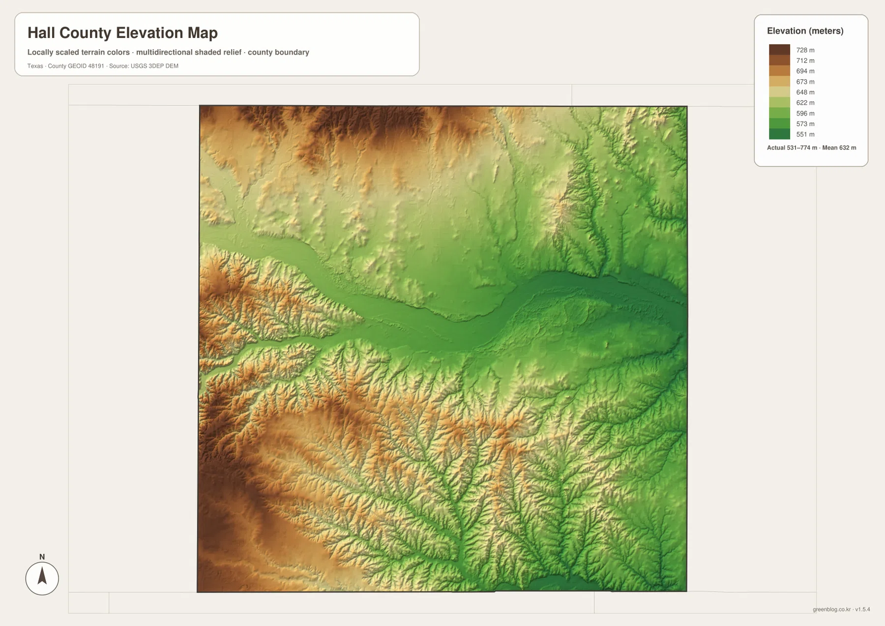
The southwest near Turkey is especially useful for comparison because the shaded relief is more sharply cut than the terrain around Memphis and Estelline. Moving from the western high ground toward the central river corridor produces a visible drop, then the landscape stays comparatively low toward the eastern boundary. That contrast is one of the most county-specific features in this map set and helps distinguish Hall County from a simple image of a uniformly flat Panhandle plain.
Why the Memphis–Estelline route looks different from the Turkey direction
On the county map, the Memphis-to-Estelline side of Hall County reads as a relatively direct eastward connection. The Turkey direction is different: it crosses the county diagonally toward terrain that is more deeply cut by tributaries and local relief. When the road map is compared with the water and elevation versions, the difference becomes obvious without requiring technical terrain analysis. The northern grid is broad and regular; the southwest contains more curving drainage lines and stronger changes in height.
This comparison is also useful when following roads beyond the county line. From Estelline, Childress County is the nearest named outside reference. From Turkey, the map naturally leads toward Motley and Briscoe counties. Memphis is better positioned for routes toward Donley and Collingsworth counties. Using the nearest community first, then adding the road and the nearest drainage, makes it easier to keep direction when studying a printed copy.
Choose the map that matches the question
The general county map is the fastest choice for boundaries, towns, and road numbers. The city-connections version is better when the main question is how Memphis relates to Turkey, Estelline, and Lakeview. The terrain-and-water map adds named rivers, creeks, lakes, and shaded relief, which is helpful for following the Prairie Dog Town Fork valley or finding smaller southern drainage features. The elevation map strips away most road detail and makes the west-to-central height change easy to compare.
For classroom work, the four images can be used as separate layers of the same county: start with towns and boundaries, add water, then compare elevation. For travel planning or local research, the road map may be the main page while the water and elevation maps explain what lies between the labeled communities. For printing, the downloadable JPG files provide more detail than the web previews and can be kept together as one Hall County reference set.
Frequently Asked Questions
Where are Memphis and Turkey on the Hall County map?
Memphis is near the northeastern part of Hall County, while Turkey is close to the southwestern corner. The city-connections map lists the direct distance from Memphis to Turkey at about 30 miles, making them useful opposite-side reference points.
Which waterway is most prominent in Hall County?
The Prairie Dog Town Fork Red River is the most prominent mapped waterway. It runs west to east through the central-northern part of the county and is joined or approached by features such as the Little Red River, Indian Creek, and Mountain Creek.
What does the elevation map show about Hall County?
The map shows elevations from about 531 to 774 meters, with an average near 632 meters. The western and northwestern uplands are higher, while the Prairie Dog Town Fork corridor forms a lower east-west valley through the county.
Sources and reference links
- U.S. Census Bureau TIGER/Line Shapefiles — official boundary and transportation geography resources.
- USGS National Hydrography — official information on rivers, streams, lakes, and hydrographic data.
- USGS 3D Elevation Program — official elevation-data program information.
- USGS The National Map Viewer — a map viewer for checking multiple official geographic layers.
Map File Information
The ZIP contains high-resolution A3 JPG versions of the Hall County, city-connections, terrain-and-water, and elevation maps. Use these files when you need larger images for printing, teaching, offline study, or personal reference.
- File Type: ZIP containing 4 JPG files
Related Maps
- Motley County Texas map
- Armstrong County Texas map
- Swisher County Texas map
- Wheeler County Texas map
- Wilbarger County Texas map
Green Map creates custom-edited map images using open geographic data sources such as geoBoundaries, Natural Earth, OpenStreetMap, and government open data. These maps are edited visual materials, not raw data files, and are provided for education, documents, presentations, and graphic reference.