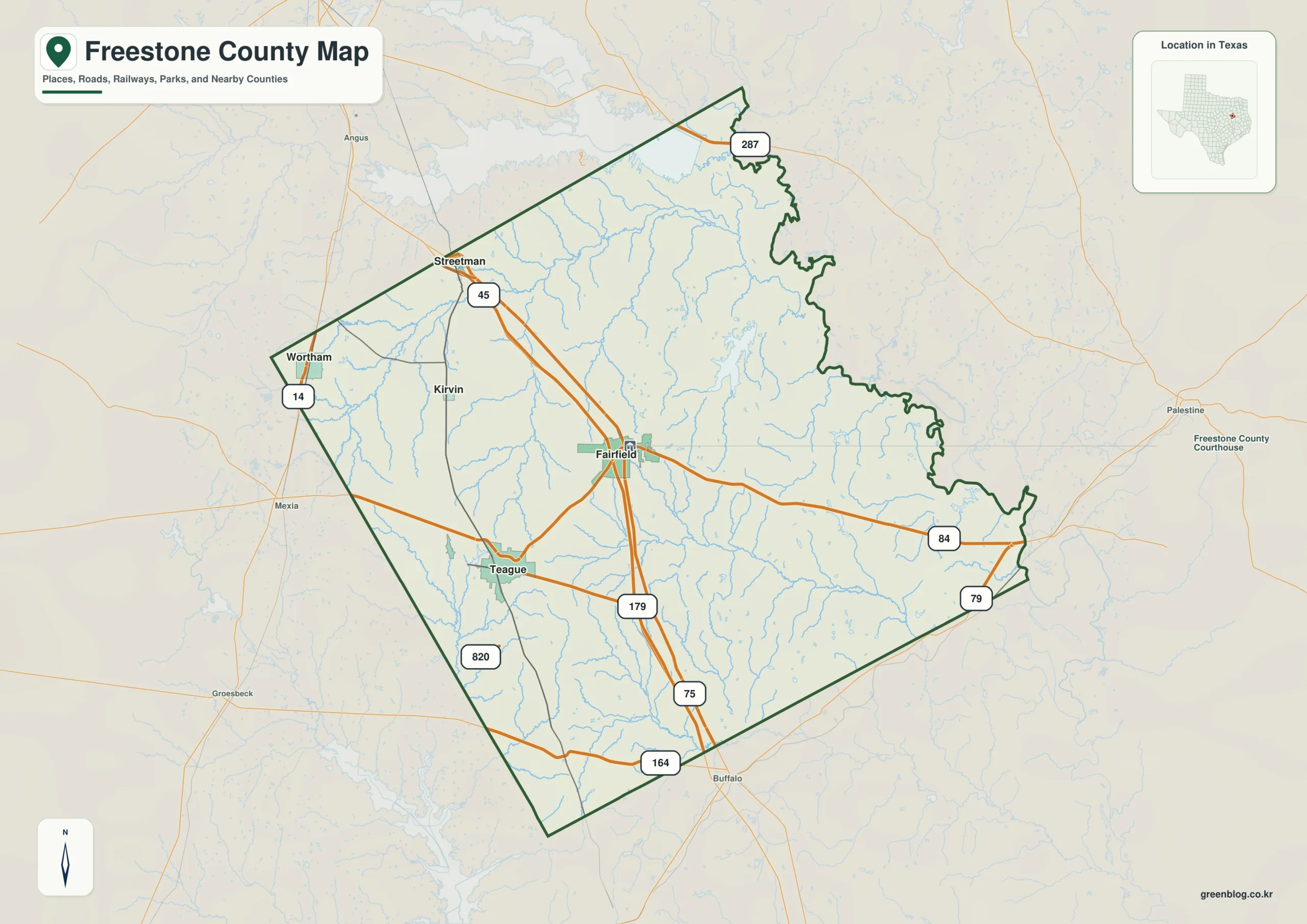
To understand Freestone County, begin with Fairfield and work outward toward Teague, Wortham, and Streetman. On a Freestone County Texas map, these places become more meaningful when they are read together with Richland-Chambers Reservoir vicinity and Trinity River basin. The goal is not simply to name locations, but to explain how settlement, transportation, physical geography, economic activity, and connections to nearby counties fit together.
Download the Freestone County map
- File format: JPG
- Image: One county map
Table of Contents
Quick Facts
- County seat: Fairfield
- Location in Texas: East-central Texas south of Corsicana
- Selected communities: Fairfield, Teague, Wortham, Streetman
- Key geographic features: Richland-Chambers Reservoir vicinity, Trinity River basin, Post Oak Savanna
- Adjacent areas: Navarro County, Henderson County, Anderson County, Leon County, Limestone County
How to Read the County as a Whole
The relationship among Fairfield, Teague, Wortham, and Streetman shows that the county should not automatically be treated as a single-centered urban system. Secondary communities can define different travel directions and service districts even when they are much smaller than the county seat.
For this county specifically, the mapped settlement pattern can be summarized this way: Fairfield lies near the center, Teague west, Wortham northwest, and Streetman north. The northern side approaches Richland-Chambers Reservoir, while the southeast becomes more wooded.
Service Centers and Smaller Communities
Although Fairfield provides the legal and administrative anchor, everyday shopping, employment, education, or medical travel may also pull residents toward Teague or Wortham. Adding Streetman to the picture helps distinguish the core from the outer service areas.
Transport Corridors and Regional Access
The road system is best interpreted as a set of functional corridors. One route may connect Fairfield with Teague, another may carry traffic toward Navarro County, and smaller roads may serve dispersed production areas. Looking at destinations rather than road classes gives the lines on the map a practical meaning.
The county-specific road and location relationship is more concrete in the following description: Interstate 45 passes through Fairfield and provides the county’s strongest north-south connection. U.S. 84 links Fairfield and Teague across the central area.
How Physical Geography Shapes the Road Network
Richland-Chambers Reservoir vicinity, Trinity River basin, and Post Oak Savanna form the physical framework of Freestone County. Water can restrict crossing points, uneven terrain can redirect roads, and broad level land can support straighter routes and larger parcels. Comparing these features with the towns helps explain why development is uneven.
Developed Areas and Open Land
Ranching, farming, lignite and energy history, highway commerce, and lake-related activity contribute to the economy The economy is not printed as a separate map layer, but its effects appear in settlement size, road access, and land subdivision. Comparing Fairfield with Teague and Wortham provides clues to where daily services, employment, and freight movement are concentrated.
The local economic and service context is more specific than a general regional description: Ranching, farming, lignite and energy history, highway commerce, and lake-related activity contribute to the economy. Fairfield’s I-45 location gives it a larger travel-service role than many similar rural county seats.
The County’s Role in the Wider Region
Looking toward Navarro County, Henderson County, and Anderson County places Freestone County in a wider regional context. Compare outbound roads from Fairfield, the continuity of Richland-Chambers Reservoir vicinity, and the direction of service travel to judge whether the county acts as an independent center or is strongly tied to a larger nearby market.
Reading Place Names Together with Terrain
Find the major centers first and the detailed features second. On a Freestone County map, that means orienting from Fairfield to Teague and Wortham, then checking how Richland-Chambers Reservoir vicinity or Trinity River basin affects the space between them, and finally extending the view across the county line.
Practical Map-Use Scenarios
For regional comparison, place Freestone County and Navarro County at the same scale and compare terrain, road density, and settlement spacing. In a report or classroom activity, highlighting Richland-Chambers Reservoir vicinity and Trinity River basin can connect physical geography with human activity, while field planning can focus on access from each local center.
Frequently Asked Questions
What should I locate first on a Freestone County map?
Start with Fairfield, then find Teague and Wortham. After that, compare their positions with Richland-Chambers Reservoir vicinity and the major road corridors to understand the settlement and travel pattern.
Why is Richland-Chambers Reservoir vicinity important when reading the county?
Richland-Chambers Reservoir vicinity is a useful physical reference because it can influence road alignment, settlement spacing, and land use. Reading it together with Trinity River basin makes internal geographic differences easier to see.
Why compare Freestone County with neighboring counties?
Routes toward Navarro County and Henderson County continue beyond the administrative boundary, and regional travel, employment, and physical geography often operate across several counties.
Related Maps
- Anderson County Texas map
- Navarro County Texas map
- Smith County Texas map
- Van Zandt County Texas map
- Robertson County Texas map
Reference
USGS The National Map Viewer — Use the official U.S. Geological Survey map service to check boundaries, hydrography, roads, terrain, and other geographic layers.
Green Map creates custom-edited map images using open geographic data sources such as geoBoundaries, Natural Earth, OpenStreetMap, and government open data.
These maps are edited visual materials, not raw data files, and are provided for education, documents, presentations, and graphic reference.