Gilmer County lies in the mountains of northern Georgia, where Ellijay and East Ellijay occupy a relatively small central valley while streams and ridges cover most of the county. The map set on this page is useful because it separates those features instead of placing every label on one image. The general county map shows roads and places, the city view emphasizes Ellijay and East Ellijay, the water map traces the Ellijay, Cartecay, and Coosawattee rivers with Carters Lake and mountain creeks, and the elevation map shows an actual range of about 212 to 1,242 meters. After reviewing the maps, you can download four high-resolution A3 JPG originals in one ZIP for printing, classroom work, presentations, or local research.
Ellijay is the easiest point from which to organize the county. Routes 5 and 515 approach the Ellijay–East Ellijay area from the south, while Routes 52, 76, and 282 spread into different mountain valleys. On the city map the two major cities sit very close together, but the water and elevation views reveal how much larger the surrounding natural landscape is. The northern and eastern sides rise into high ridges, numerous tributaries descend through narrow valleys, and the southwest leads toward Carters Lake. Gilmer County therefore makes more sense as a mountain watershed centered on Ellijay than as a simple collection of towns.
Table of Contents
Roads Converging on Ellijay Between Mountain Valleys
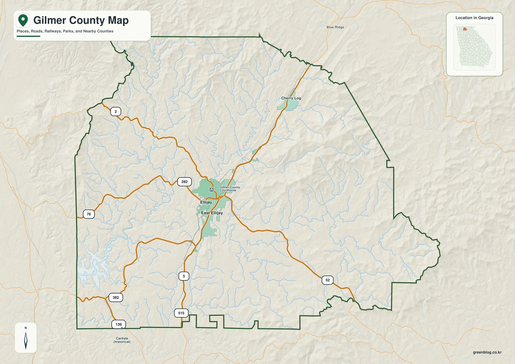
The general map places Ellijay and East Ellijay slightly west of the county’s center. The Gilmer County Courthouse is marked near Ellijay, and Cherry Log appears farther north along the main north-south corridor. Routes 5 and 515 enter from the south and converge on the urban area. Route 52 continues east through the mountains, Route 76 heads west, and Route 282 provides another important western and northwestern connection. Routes 382 and 136 appear closer to the southwestern and southern boundary.
The road pattern is shaped by terrain rather than by a simple grid. Major routes bend through valleys and converge around Ellijay before turning toward higher country. Large sections of the north and east have fewer prominent road labels but many streams and shaded ridges. The map is therefore most useful for county-scale orientation—seeing which routes connect the central cities with Cherry Log, the western valleys, the Carters Lake side of the county, and the eastern mountain districts. Current street navigation is still better for local turns and real-time driving conditions.
Even on the general map, water is almost everywhere. Thin blue tributaries cross the county from ridge to valley, and the southwest edge includes part of the Carters Lake shoreline. The eastern and northeastern boundary is irregular as it follows steep mountain terrain, while the southern edge contains a series of small notches and projections. These details make Gilmer County visually different from a lowland county with a simple rectangular outline.
Ellijay and East Ellijay in a Two-City View
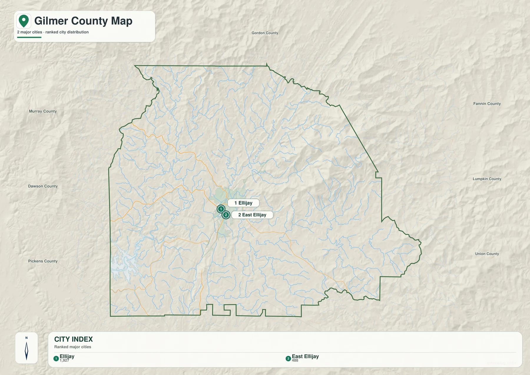
The city map removes most road and water labels and highlights only two major cities. Its CITY INDEX shows Ellijay at 1,927 and East Ellijay at 488. Those numbers are the values printed on the supplied map and are reproduced here to describe its ranking. They should not be treated as newly verified population estimates for this article; current official figures can be checked through the Census QuickFacts source below.
The geographic point is the closeness of the two labels. Ellijay lies just northwest of East Ellijay, and both occupy the same central valley area. Unlike a county where major towns are separated by long connector lines, Gilmer County’s principal city labels form one compact cluster. That does not mean the rest of the county is empty. Cherry Log appears on the general map to the north, and broad mountain areas extend in every direction. The city map simply isolates the two major incorporated-city references so their position can be understood without competing road and stream labels.
Neighboring county names around the city view add regional context. Murray County lies to the west, Gordon County is labeled north of the map frame, Fannin County appears toward the northeast, Lumpkin and Union counties are to the east, and Dawson and Pickens provide western and southwestern references. These labels are for orientation rather than legal survey work. Their main value is showing that Ellijay sits inside a broad mountain county surrounded by other northern Georgia counties rather than close to one outer edge.
Ellijay, Cartecay, and Coosawattee Rivers with Carters Lake
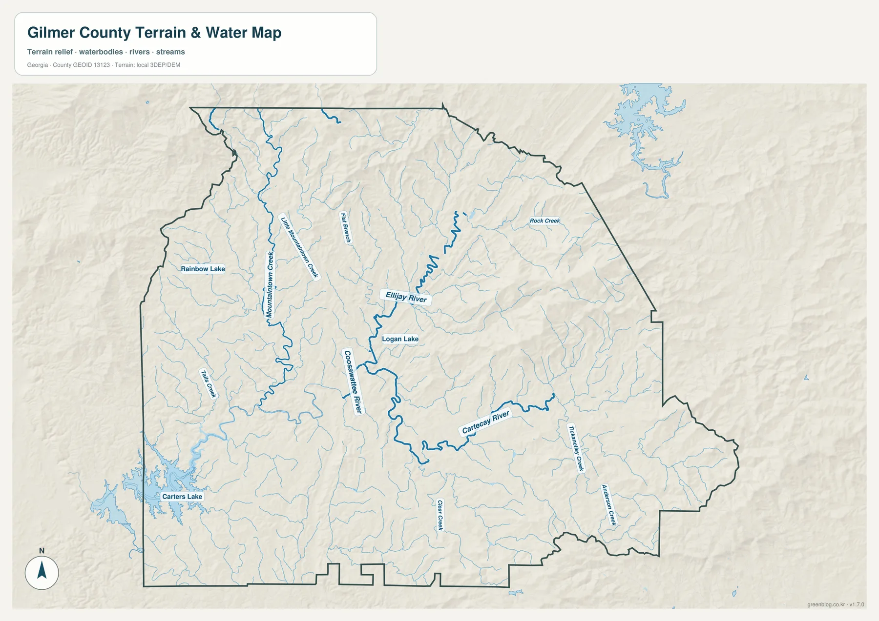
The central river relationship is the most important feature on the water map. The Ellijay River approaches the middle of the county from the northeast, while the Cartecay River comes in from the east. Their channels meet in the Ellijay area, and the Coosawattee River continues downstream from the same central valley. This explains why the city and road cluster occupies a location that looks comparatively open on the elevation map: it sits where major mountain valleys converge rather than on one of the highest ridges.
Mountaintown Creek provides a strong western reference. It runs through the northwestern and central-western part of the county, with Little Mountaintown Creek labeled nearby. Flat Branch, Tails Creek, Rock Creek, Anderson Creek, and other tributaries add detail in different parts of the map. Many more blue lines are unnamed at this scale. Their density shows how extensively the mountain slopes are divided by small drainage valleys.
Carters Lake is the largest named body of water shown near the southwestern boundary. Logan Lake appears close to the central river system, while Rainbow Lake is labeled farther west. These named waters differ greatly in size and function; they are used here as map reference points, not as equivalent recreational or reservoir features. Carters Lake is especially helpful for orienting the southwestern side because its branching shoreline is easy to recognize on both the water and general maps.
This water view is intended for county-scale geographic reference. It does not determine parcel boundaries, flood-insurance status, channel depth, legal shoreline, or boating conditions. Specialized current sources are necessary for those questions. Its strength is showing how the Ellijay, Cartecay, and Coosawattee rivers relate to Mountaintown Creek, Carters Lake, and the dense network of smaller mountain tributaries.
A 212–1,242 Meter Range Across Steep Ridges and Valleys
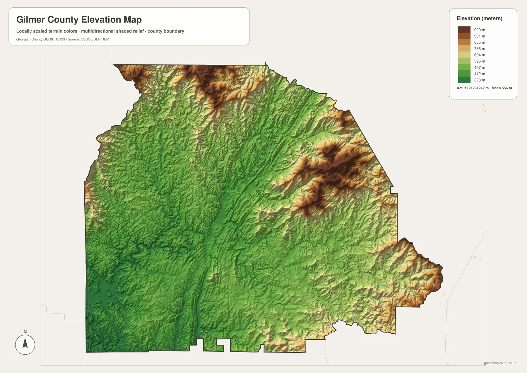
The elevation map reports an actual range of approximately 212 to 1,242 meters, with a mean of 556 meters. That spread is large enough to make Gilmer County unmistakably mountainous. Dark brown and tan colors dominate several ridges along the north and northeast, and another strong belt of high terrain rises along the eastern side. The central and southwestern valleys are much greener and lower, producing a sharp visual contrast that is not apparent on the simplified city map.
The northern edge contains some of the highest terrain. Long ridges descend from that high country toward the county interior, separated by narrow green valleys. The eastern side has another concentration of steep relief, with multiple ridges packed closely together. When these features are compared with the water map, the network of small streams makes sense: tributaries occupy the lower channels between ridges and flow toward the larger rivers in the center.
Ellijay sits within a broader low corridor. The Ellijay and Cartecay rivers enter that central valley, and the Coosawattee continues away from it. The southwest toward Carters Lake also remains comparatively low. Even these green areas are not truly flat; shorter ridges and hills repeat throughout the lower parts of the county. They simply stand well below the highest northern and eastern mountain slopes.
The elevation colors and hillshade are meant to compare broad terrain across the county. They should not be used as survey-grade elevation for a building site, road design, grading plan, or drainage project. Exact site work requires more detailed elevation data and, when appropriate, field measurement. For general geography, however, the 212–1,242 meter range clearly shows why roads and settlements concentrate in valleys while much of the county remains strongly ridged.
Why the Mountains Matter More Than the City Count
Gilmer County looks very simple if only the city map is considered: two labels sit close together near the center. The general map adds roads and Cherry Log, but the water and elevation maps reveal the county’s larger structure. Rivers converge near Ellijay, Mountaintown Creek occupies a western valley, Carters Lake anchors the southwest, and high ridges dominate the north and east. The contrast between the compact city cluster and the broad mountain landscape is one of the most useful ideas in the map set.
For a basic county-location slide, the general map is usually the best first choice because it includes roads, towns, streams, and the boundary. The city map is cleaner when the goal is simply to show where Ellijay and East Ellijay sit. The water map is better for explaining the river system and Carters Lake, while the elevation view provides the strongest picture of the high ridges and low valleys. Using the maps side by side allows a reader to connect settlement, transportation, water, and relief without overcrowding one image.
The existing source article identifies Gilmer County as established in 1832 and describes apple orchards, mountain tourism, waterways, lodging, and Carters Lake as parts of the county’s local setting. The revised map page keeps that context secondary to what can actually be seen in the supplied maps. Ellijay’s central valley, the three major river names, Carters Lake, and the elevation difference exceeding 1,000 meters provide a more concrete geographic explanation of why Gilmer County has such a strong mountain identity.
The downloadable A3 files are useful when the webpage previews are too small for the intended project. Each JPG retains a different focus—county reference, city distribution, water, or elevation—while using the same county boundary. That makes the set suitable for printing, classroom comparison, reports, or presentation slides without forcing every road, stream, city, and contour cue onto a single crowded map.
Frequently Asked Questions
Which cities are emphasized on the city map?
The supplied city map emphasizes Ellijay and East Ellijay. Its CITY INDEX shows Ellijay at 1,927 and East Ellijay at 488, while the more detailed county map also labels Cherry Log farther north.
Which rivers and lakes are easiest to identify?
The water map clearly labels the Ellijay River, Cartecay River, and Coosawattee River around the central valley. Mountaintown Creek is prominent to the west, and Carters Lake is the largest named water body shown near the southwestern boundary.
What elevation range does the map show?
The elevation legend states an actual range of about 212 to 1,242 meters and a mean of 556 meters. The highest terrain is concentrated in the northern and eastern ridges, while the central river valleys and southwest are generally lower.
What is included in the downloadable ZIP?
The archive contains four high-resolution A3 JPG files: a general Gilmer County map, a city map, a water map, and an elevation map. Each file emphasizes a different aspect of the same county.
Map File Information
Gilmer County A3 Map Files
- Included Files: General county, city, water, and elevation maps
- File Type: Four high-resolution A3 JPG files bundled in one ZIP archive
- Intended Use: Printing, education, presentations, and map-based projects
Related Maps
Sources and Reference Material
- Gilmer County government – county administration and local information
- U.S. Census Bureau QuickFacts: Gilmer County – current official statistics
- New Georgia Encyclopedia: Gilmer County – county history and regional background
- U.S. Census Bureau TIGER/Line Shapefiles – county boundary and geographic reference data
- USGS National Hydrography – river, stream, and water-feature data
- USGS 3D Elevation Program – elevation data
Green Map creates custom-edited map images using open geographic data sources such as geoBoundaries, Natural Earth, OpenStreetMap, and government open data. These maps are edited visual materials, not raw data files, and are provided for education, documents, presentations, and graphic reference.