Houston County occupies Minnesota’s far southeastern corner, where the Mississippi River forms the long eastern edge and a deeply cut interior rises toward Caledonia, Spring Grove, and the Iowa line. La Crescent and Brownsville sit close to the big river, Houston lies in the Root River valley, and Caledonia stands on higher inland ground. The supplied maps make those contrasts much easier to see than a simple outline alone.
This article uses the actual labels, waterways, roads, and elevation colors shown in the package rather than treating the county as a generic Minnesota example. High-resolution JPG versions of all four map views are included in one ZIP download for printing, teaching, presentations, or image editing after you review the web versions below.
Table of Contents
A county edge shaped by the Mississippi River
The eastern boundary is the first feature that separates Houston County from many inland counties. Instead of following one long straight line, it bends with the Mississippi River and its broad floodplain. La Crescent occupies the northeastern river side, Hokah lies just inland near the lower Root River, and Brownsville appears farther south against the same river corridor. Route 26 follows the southeastern side near the river, providing a useful reference for the long north-south edge.
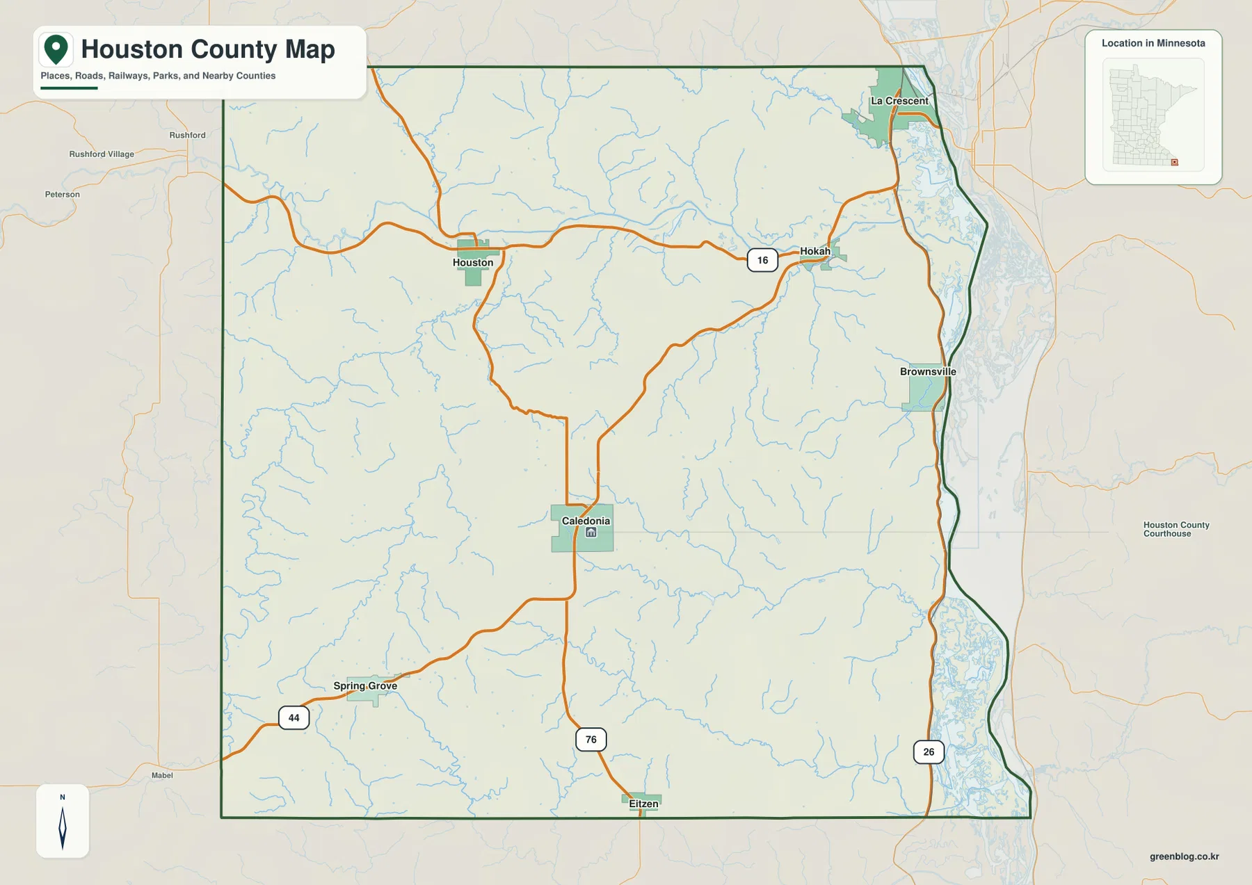
Travel west from the river and the road pattern follows the valleys and uplands rather than a simple urban grid. Route 16 runs across the northern interior through the Houston-Hokah area, while Route 76 links Houston with Caledonia and continues toward Eitzen near the Iowa border. Route 44 reaches Spring Grove in the southwest. These roads help explain why the principal communities are spread across very different parts of the county instead of forming one continuous corridor.
The river side is also visibly more irregular than the western county line. Backwaters and low floodplain areas appear beside the Mississippi, especially north of Brownsville and around the La Crescent side. The general map is useful for county orientation and road context, but it is not a live traffic map; current construction, winter conditions, closures, and driving times should be checked with transportation services before travel.
Six cities spread between river valleys and uplands
The simplified city view highlights La Crescent, Caledonia, Spring Grove, Houston, Hokah, and Brownsville. They form a wide geographic spread: La Crescent is in the northeast, Brownsville is down the Mississippi side, Caledonia is near the south-central interior, and Spring Grove sits well to the southwest. Houston and Hokah occupy the northern Root River corridor, which gives them a different setting from the higher inland communities.
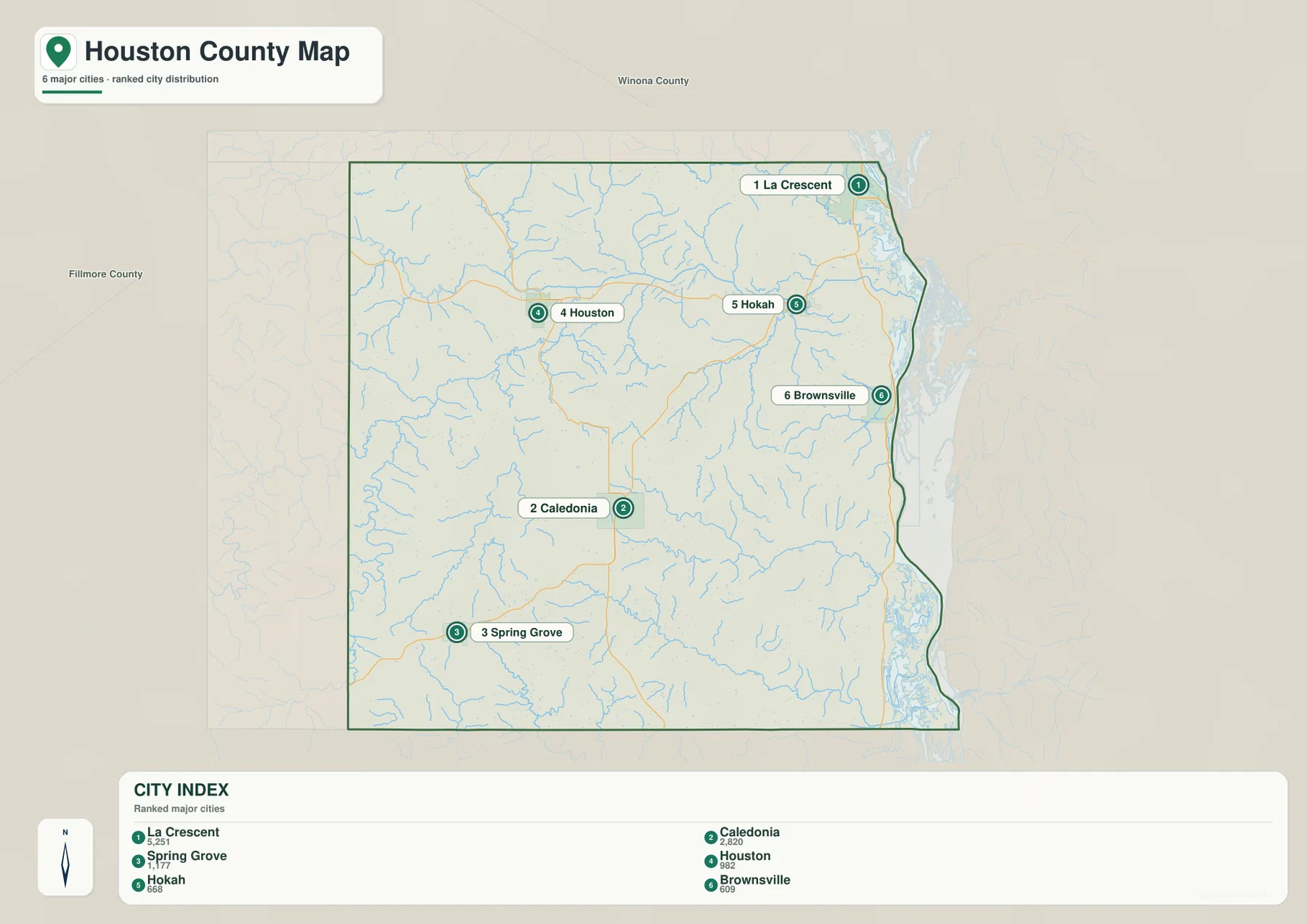
The CITY INDEX printed on the map lists La Crescent at 5,251, Caledonia at 2,820, Spring Grove at 1,177, Houston at 982, Hokah at 668, and Brownsville at 609. Those values are best treated as the index figures embedded in this map rather than as claims about the latest official population estimate. They show the relative order of the selected communities and reinforce how much larger La Crescent appears than the small towns farther south and inland.
Location tells a more interesting story than rank alone. La Crescent and Brownsville are tied closely to the Mississippi lowlands, Caledonia and Spring Grove occupy higher interior country, and Houston lies in a long river valley cut through the uplands. Hokah sits near the point where that northern valley opens toward the Mississippi. A city-only map makes the spacing obvious, while the water and elevation maps explain why the places occupy such different settings.
This view should not be interpreted as a driving-distance chart. The straight visual gap between two labels ignores winding valleys, steep slopes, river crossings, and the actual route network. For travel, use the city map to understand direction and then return to the county map or a current navigation service for roads and driving conditions.
The Root River opens across the northern interior
The Root River is the dominant inland waterway on the supplied terrain-and-water map. It enters the county from the west, crosses the northern interior near Houston, and continues east toward Hokah and the Mississippi. The South Fork Root River approaches from the southwest and joins the larger valley, while many short tributaries descend from the surrounding ridges. Together they create a broad green corridor that stands out clearly on the elevation map.
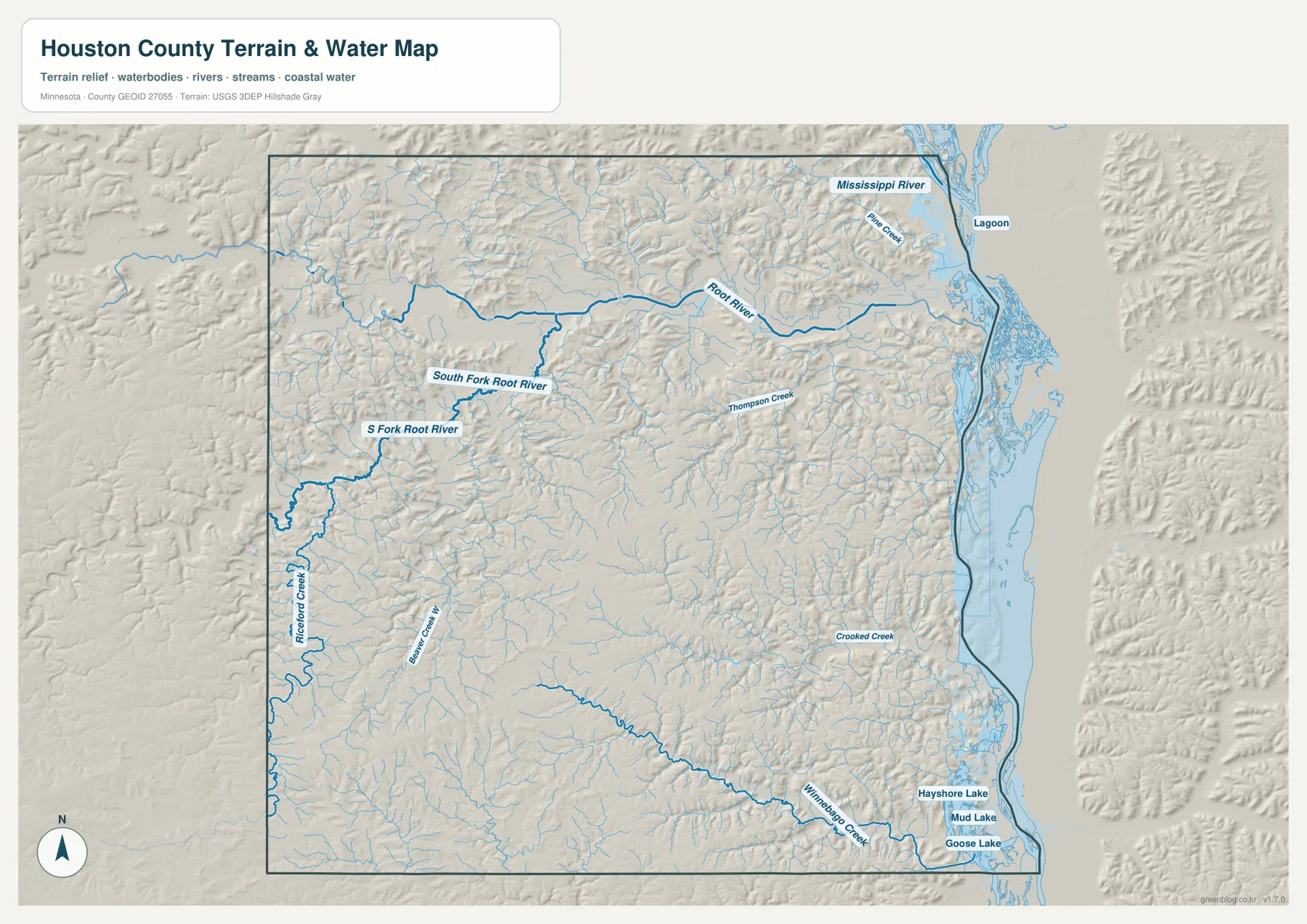
Several smaller names help show how finely cut the landscape is. Thompson Creek crosses the east-central interior, Pine Creek is labeled near the upper Mississippi side, and Riceford Creek and Beaver Creek occupy narrow valleys farther west. None of these waterways is as visually dominant as the Root River, but together they explain the repeated ravines and branching low ground that cover much of the county.
Minnesota DNR treats the Rushford-to-Mississippi reach as one of the Root River water-trail segments and identifies Houston as a notable point along that stretch. That official context matches the supplied maps: Houston sits close to the river, and the valley broadens as it approaches Hokah and the Mississippi floodplain. The city, water, and elevation views therefore tell the same geographic story from different levels of detail.
Winnebago Creek and the lower Mississippi backwaters
South of Caledonia, the drainage shifts away from the Root River system. Winnebago Creek crosses the southern part of the county toward the Mississippi, while Crooked Creek drains the east-central and southeastern uplands. Near the river, Hayshore Lake, Mud Lake, and Goose Lake appear as distinct water bodies within the broad lowland beside the main channel. The contrast between narrow interior creeks and wide river backwaters is especially clear in this part of the map.
The southern interior is not a smooth plateau. Small tributaries descend from high ground around the Spring Grove-Caledonia-Eitzen area and form a dense set of narrow valleys before joining larger creeks. When the water map is compared with the elevation surface, those channels line up with green cuts through otherwise tan and brown uplands. This gives the southern half a rugged appearance even away from the Mississippi bluffs.
The water layer is intended for geographic reference, not as a flood-hazard, navigation, parcel, or fishing-regulation map. Water depth, access rules, ownership, and current river conditions require dedicated county, state, or federal information. Its value here is showing how streams and backwaters fit between the towns and the steeply divided terrain.
From 190-meter river bottoms to 407-meter uplands
The supplied elevation map reports an actual county range of about 190 to 407 meters, with a mean near 303 meters. The lowest greens trace the Mississippi River edge and the Root River valley, while broad tan and brown areas cover much of the central, western, and southwestern interior. A difference of roughly 217 meters across a relatively compact county produces a much stronger valley-and-ridge pattern than a statewide overview would suggest.
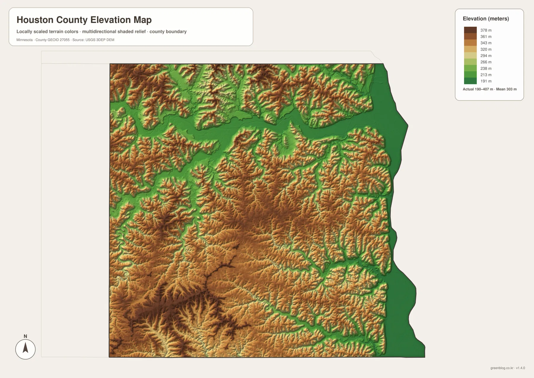
The Root River appears as a long, low green corridor across the north. Ridges rise sharply on both sides, then break into many smaller ravines that feed the main valley. Around Houston, the town sits within this lower passage; farther east near Hokah, the valley opens toward the much wider Mississippi lowland. La Crescent occupies another narrow transition between high bluff country and the river floodplain.
The central and southwestern uplands around Caledonia and Spring Grove are higher overall, but they are deeply dissected rather than flat. Repeated creek valleys cut into the brown and orange surface, especially toward the south and southeast. Those ridges and valleys continue toward Eitzen and the Iowa border, then drop through Winnebago Creek and other channels toward the Mississippi side.
This map is appropriate for county-scale comparison, not site engineering or survey work. It cannot substitute for a measured building elevation, road grade, drainage design, or parcel-level contour survey. Detailed USGS 3D Elevation Program products or professional survey data should be used when exact elevations matter.
Caledonia and the river towns occupy very different ground
Putting the city and elevation views together makes the county’s settlement pattern easier to understand. La Crescent is closely tied to the Mississippi lowland, Hokah sits where the Root River valley approaches the big river, and Houston lies farther upstream inside the northern valley. Those towns share access to low corridors, but the surrounding slopes rise quickly and make the landscape feel enclosed in places.
Caledonia has a different setting. The official Houston County website places the Historic County Courthouse in Caledonia, and the maps show the community on higher interior ground rather than within the main Mississippi or Root River bottom. Spring Grove is even farther southwest among rolling uplands, while Eitzen sits close to the Iowa line. These positions help explain why the county’s administrative center is not one of the larger riverfront towns.
Brownsville is small on the city index but valuable as a geographic reference because it anchors the southern Mississippi corridor. North of it lie the river communities and backwaters; west of it, the land rises quickly into narrow creek valleys and uplands. Reading Brownsville together with La Crescent, Houston, and Caledonia gives a better picture of the county than focusing only on the largest population center.
Choosing a map for roads, towns, water, or relief
The general county map is the best starting point when roads, municipal locations, and the irregular Mississippi boundary need to appear together. It shows how Route 16 links the northern interior, how Route 76 reaches Caledonia and Eitzen, and how Route 44 serves the Spring Grove side. The city map is cleaner when only the six ranked communities need to be compared.
Use the water map when the Root River, South Fork Root River, Mississippi River, Winnebago Creek, or southeastern lakes are central to the task. The elevation map adds the missing vertical context by showing why those waterways occupy long low corridors between ridges. In a county with such strong relief, combining the water and elevation views is often more informative than treating either one in isolation.
For printing or editing, the original JPG files in the ZIP provide more resolution than the WebP previews embedded in the article. Each JPG measures 3638 by 2572 pixels, and the archive contains the county, city, water, and elevation maps. A school handout might use the city and elevation views together, while a river-focused presentation could pair the county and water maps without crowding the page with unrelated detail.
When official county and state sources should take over
These maps are designed for orientation, explanation, and downloadable reference. Parcel boundaries, taxes, permits, surveys, official road records, and other administrative decisions should rely on current Houston County sources instead. The county’s official website provides department information and identifies the Historic County Courthouse in Caledonia, along with links to property and GIS services.
For recreation or river access, Minnesota DNR’s Root River material is more appropriate than a general-purpose map. U.S. Census Bureau TIGER/Line files can support boundary and road work, USGS National Hydrography provides water data, and the USGS 3D Elevation Program is the better source for detailed elevation products. The maps on this page are meant to make the major county relationships easy to understand and reuse.
Frequently Asked Questions
Why do La Crescent and Caledonia look so different on the elevation map?
La Crescent is close to the low Mississippi River corridor and adjacent bluff slopes, while Caledonia is on higher interior ground. The supplied elevation surface makes that contrast clear even though the two communities are in the same county.
Where does the Root River cross Houston County?
The Root River crosses the northern part of the county from west to east, passing near Houston before continuing toward Hokah and the Mississippi River. The South Fork Root River joins the system from the southwest, and the elevation map shows the main river corridor as a long low valley.
What elevation range is shown for Houston County?
The supplied elevation map reports an actual range of about 190–407 meters and a mean near 303 meters. The Mississippi and Root River valleys are among the lowest areas, while higher ridges dominate much of the central, western, and southwestern interior. Site-specific elevations require detailed USGS or survey data.
Map File Information
Download the original high-resolution JPG versions of the Houston County maps shown on this page in one ZIP file.
- Included Files: county map, city map, water map, elevation map
- Printable Size: each JPG is 3638 × 2572 px
- File Type: ZIP containing 4 JPG files
Related Maps
Sources and references
- Houston County, Minnesota official website – county government, community, and contact information
- Minnesota DNR Root River segments and maps – Root River water-trail segments and reference material
- U.S. Census Bureau TIGER/Line Shapefiles – boundary, road, and place data
- USGS National Hydrography – river, stream, and water data
- USGS 3D Elevation Program – elevation data and products
Green Map creates custom-edited map images using open geographic data sources such as geoBoundaries, Natural Earth, OpenStreetMap, and government open data. These maps are edited visual materials, not raw data files, and are provided for education, documents, presentations, and graphic reference.