Hennepin County brings together the dense Minneapolis side of the county, large suburban cities to the north and south, a lake-rich western half, and the Mississippi River along the east. Rogers and Dayton occupy the far northwestern extension, Maple Grove and Plymouth sit across the north-central interior, and Bloomington and Eden Prairie anchor the south. That range of places makes the county easier to understand when roads, water, and elevation are viewed together.
This page uses the supplied maps to explain those visible relationships without turning the article into a technical GIS report. The original high-resolution JPG map files are also available in one ZIP download, so they can be used for printing, classroom work, presentations, or local reference after reviewing the smaller web versions here.
Table of Contents
Minneapolis and the road pattern across Hennepin County
Minneapolis is the clearest eastern reference point on the general county map. Plymouth and Minnetonka lie to its west, Maple Grove and Brooklyn Park occupy a large part of the north-central area, and Eden Prairie and Bloomington fill much of the south. Farther west, Orono, Medina, Independence, and Minnetrista spread across a landscape with larger municipal areas and many lakes, while Rogers and Dayton sit in the county’s irregular northern extension.
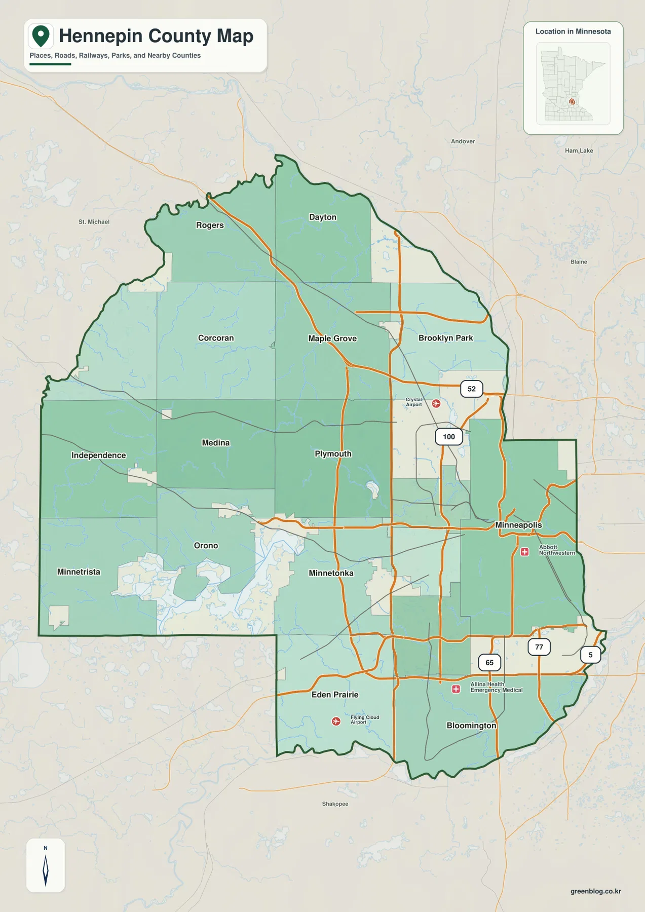
Several numbered routes are visible, including 52, 100, 77, 65, and 5. The eastern and southern parts of the county show a denser road pattern around Minneapolis, Bloomington, and nearby communities, while the western side has wider spacing between major routes. That difference is useful for orientation: the map is not simply showing one continuous urban grid, but a county that changes noticeably from the Minneapolis side toward the lake country in the west.
Maple Grove is particularly useful as a middle reference because it falls between Rogers and Dayton to the north, Plymouth to the south, and Brooklyn Park to the east. Eden Prairie plays a similar role in the south, where routes converge between the western lakes and Bloomington. The map is a geographic overview rather than a live traffic source, so current congestion, closures, construction, and driving times should be checked through up-to-date transportation services.
Six major cities and a county that is not centered on Minneapolis
The city map highlights Minneapolis, Bloomington, Brooklyn Park, Plymouth, Maple Grove, and Eden Prairie. Minneapolis appears close to the eastern side of the county instead of at its geographic center. Bloomington is near the southern edge, Eden Prairie sits southwest of it, and the three northern suburban cities form a broad cluster across the central and northeastern part of Hennepin County.
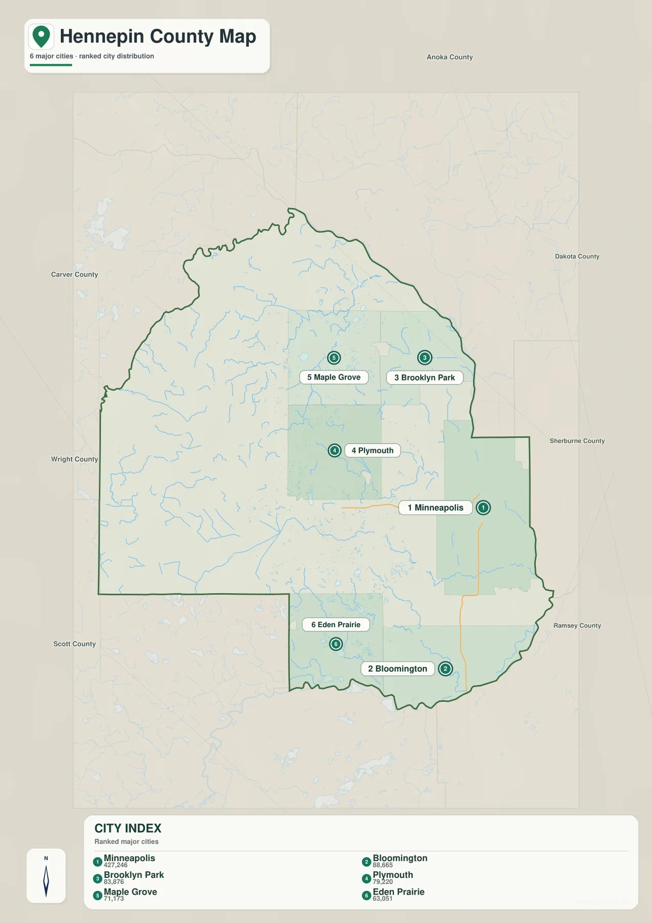
The CITY INDEX printed on the supplied map lists Minneapolis at 427,246, Bloomington at 88,665, Brooklyn Park at 83,876, Plymouth at 79,220, Maple Grove at 71,173, and Eden Prairie at 63,051. These figures should be treated as values embedded in the map rather than as a statement of the latest official population estimates. For this page, their main use is to show the relative ordering of the six selected cities.
The distribution matters as much as the ranking. Brooklyn Park and Maple Grove sit fairly close to one another in the north, with Plymouth immediately to the south. Bloomington and Eden Prairie form a separate southern pair, while Minneapolis remains farther east. A reader who only knows Minneapolis may therefore underestimate how far Hennepin County extends into the western lake region and the northwestern communities.
This simplified city view is useful for teaching, presentations, and quick location checks, but it does not measure road distance or travel time between markers. Lakes, streams, roadway geometry, and interchange locations can make the actual trip quite different from the straight visual separation on the page. Use the city map for direction, then move back to the general map or a current navigation service for travel details.
Bays, lakes, and streams across the western half
The water map changes the visual emphasis completely. In the western and southwestern part of Hennepin County, Maxwell Bay, Jennings Bay, Harrison Bay, Crystal Bay, Lafayette Bay, Halsted Bay, and Phelps Bay are labeled close together. Numerous additional blue water bodies surround them, making this side of the county much more lake-dense than the Minneapolis riverfront area.
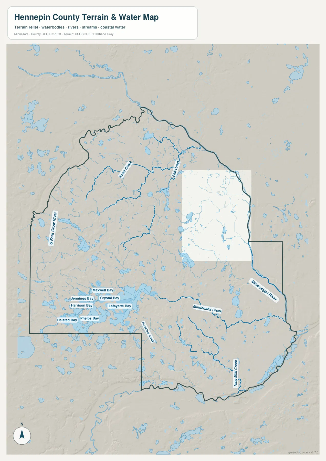
North of the western bay group, Rush Creek and Elm Creek cross the interior, while the South Fork Crow River is labeled along the northwestern side. Smaller branches feed into these larger channels, giving the north and west a web of narrow waterways in addition to the larger lakes. When compared with the general map, that network helps explain why places such as Independence, Orono, Minnetrista, and Medina contain so much visible water within and around their municipal boundaries.
The water map is a location reference, not a flood map or navigation chart. It does not provide water depth, shoreline ownership, boating restrictions, flood-hazard zones, or parcel boundaries. Those questions require current county, state, or federal sources. Here, the main value is showing how strongly lakes and streams shape the western half of Hennepin County and how different that landscape is from the dense urban east.
The Mississippi River, Minnehaha Creek, and southern drainage
The Mississippi River is the dominant water feature on the eastern side. It enters the county from the northeast, passes the Minneapolis area, and continues along the southeastern edge. Because it is drawn much more prominently than the smaller creeks, it provides a simple reference for understanding the low eastern side of the county and the position of Minneapolis relative to the river.
Minnehaha Creek runs eastward through the central-southern urban area toward Minneapolis. Farther south, Nine Mile Creek follows a separate path through the southern part of the county, while Plymouth Creek is labeled in the west-central area. These waterways cross areas that are otherwise heavily developed, so the county’s water geography is not confined to the rural western edge or to the Mississippi itself.
Matching the creek locations to the city map adds useful context. Plymouth sits among smaller lakes and drainage lines, Minneapolis is close to the Mississippi and the downstream end of Minnehaha Creek, and Bloomington occupies the lower southeastern side near the major river corridor. This is why the water map is useful even for readers whose main interest is city geography rather than natural features.
A 212–342 meter range from western uplands to eastern lowlands
The supplied elevation map reports an actual county range of about 212 to 342 meters, with a mean near 279 meters. Browns and tans cover much of the west and northwest, indicating higher ground, while greens become more common toward Minneapolis, the Mississippi River, and the southeastern side. The roughly 130-meter difference is enough to create a clear county-wide contrast even though Hennepin County is not mountainous.
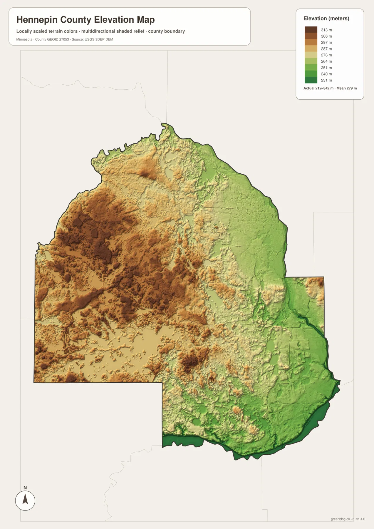
The high western surface is not uniform. Ridges, shallow valleys, and many lake depressions interrupt the broad tan and brown areas around the Independence, Medina, and Corcoran side of the county. Farther north, elevated terrain continues toward Rogers and the northwestern boundary. These shapes line up with the complicated stream and lake network shown on the water map rather than forming one simple plateau.
Lower green terrain dominates the east, especially along the Mississippi River. The south and southeast also contain broad low areas associated with major river corridors, while the central interior alternates between modest uplands and narrow drainage lows. Looking at the elevation and water maps together makes it easier to see why several creeks occupy distinct lower strips through otherwise developed suburbs.
This elevation surface is suitable for broad geographic comparison, not engineering or surveying. It should not be used to determine a building pad, exact road grade, drainage design, or parcel-level elevation. Precise work should use detailed USGS 3D Elevation Program data or a professional survey. The map on this page is best for seeing how the higher western half transitions toward lower river country in the east.
How city geography changes from east to west
Hennepin County is unusual on these maps because large urban areas and extensive natural water features appear within a short county-wide span. Minneapolis is tied visually to the Mississippi corridor, while Brooklyn Park and Maple Grove occupy large northern suburban areas. Moving west from Plymouth and Minnetonka brings more lakes, bays, and open municipal territory into view, and the elevation surface generally rises at the same time.
Plymouth provides a useful midpoint for comparing those changes. It is one of the six highlighted cities, it lies among several water features including Plymouth Creek, and it sits within a transition zone between lower eastern terrain and higher western ground. A single city therefore touches several of the geographic themes shown across the four supplied maps without needing to be described as either purely urban or purely lake-country.
The southern pair of Eden Prairie and Bloomington shows another contrast. Eden Prairie lies closer to the western lake region and mixed upland terrain, whereas Bloomington extends toward lower ground along the major southeastern river corridor. On a simple city map the two places may look like neighboring southern suburbs, but the water and elevation views reveal different surrounding landscapes.
Which Hennepin County map fits the task?
Use the general map when boundaries, major roads, and a wider set of community names need to appear together. It is the most useful view for placing Rogers, Dayton, Maple Grove, Plymouth, Minneapolis, Eden Prairie, Bloomington, and the western communities in one frame. The simplified city map works better when the six highlighted cities are the only locations that need to stand out.
For rivers, creeks, bays, and lake geography, the water map provides far more detail. It is the best choice for locating the Mississippi River, Minnehaha Creek, Nine Mile Creek, Elm Creek, Rush Creek, the South Fork Crow River, and the western bay cluster. Pairing it with the elevation map is useful when the goal is to understand why some waterways follow long low corridors and why the west appears more elevated than the east.
The downloadable JPG originals are better suited to print and image editing than the smaller WebP previews used in the article. Each JPG measures 2572 by 3638 pixels, and the ZIP contains the county, city, water, and elevation maps. Selecting only the map needed for a worksheet or presentation keeps the final layout clear instead of forcing every type of information onto one image.
Using official Hennepin County and federal map sources
The maps on this page are designed for county-wide orientation, explanation, and download. They are not replacements for official parcel, survey, tax, permitting, or legal boundary records. Hennepin County maintains a Maps and data page through its Surveyor’s Office for users who need official county map resources and more detailed local information.
Federal sources are useful when a task requires the underlying data rather than an overview graphic. U.S. Census Bureau TIGER/Line files provide boundary, road, and place information; USGS National Hydrography covers rivers and streams; and the USGS 3D Elevation Program provides elevation products. Those sources should take priority for technical work, while the maps here are intended to make the major geographic relationships easy to see and reuse.
Frequently Asked Questions
Which map is best for comparing Minneapolis with the major suburbs?
The city map is the quickest option for comparing Minneapolis, Bloomington, Brooklyn Park, Plymouth, Maple Grove, and Eden Prairie. Use the general county map as well when you need the surrounding communities and numbered roads for additional context.
Where are the higher and lower parts of Hennepin County?
The supplied elevation map shows a range of about 212–342 meters with a mean near 279 meters. Higher terrain is more common in the west and northwest, while lower ground follows the Mississippi River and much of the eastern and southeastern side. Exact site elevations should be checked with detailed USGS data or survey information.
What waterways are labeled besides the Mississippi River?
The water map labels Minnehaha Creek, Nine Mile Creek, Plymouth Creek, Elm Creek, Rush Creek, and the South Fork Crow River. It also identifies western bays including Maxwell, Jennings, Harrison, Crystal, Lafayette, Halsted, and Phelps bays.
Map File Information
Download the original high-resolution JPG versions of the Hennepin County maps shown on this page in one ZIP file.
- Included Files: county map, city map, water map, elevation map
- Printable Size: each JPG is 2572 × 3638 px
- File Type: ZIP containing 4 JPG files
Related Maps
Sources and references
- Hennepin County Maps and data – official county map and survey resources
- U.S. Census Bureau TIGER/Line Shapefiles – boundary, road, and place data
- USGS National Hydrography – river, stream, and water data
- USGS 3D Elevation Program – elevation data and products
Green Map creates custom-edited map images using open geographic data sources such as geoBoundaries, Natural Earth, OpenStreetMap, and government open data. These maps are edited visual materials, not raw data files, and are provided for education, documents, presentations, and graphic reference.