Hubbard County stretches north from the busy Park Rapids lake country into a quieter interior of rivers, forests, and scattered lakes. Park Rapids is the strongest southern center, Nevis and Akeley continue east and northeast from it, and Laporte sits much farther north. Between those communities, the map shows a striking combination of water and rolling high ground rather than one uniform landscape.
This article uses the actual roads, city connections, waterways, and elevation information shown in the supplied map package. Original high-resolution JPG versions of the county, city-connection, water, and elevation maps are also available together in one ZIP download for printing, classroom projects, presentations, and image editing.
Table of Contents
Park Rapids makes the road map easy to orient
Park Rapids is the easiest place to begin on the general county map. Highway 34 crosses the city and continues east toward Nevis and Akeley, while Highway 71 runs north and south through the Park Rapids side of the county. The road pattern is noticeably denser here than in the far north, which reinforces the city’s role as the main reference point for the southern half of Hubbard County.
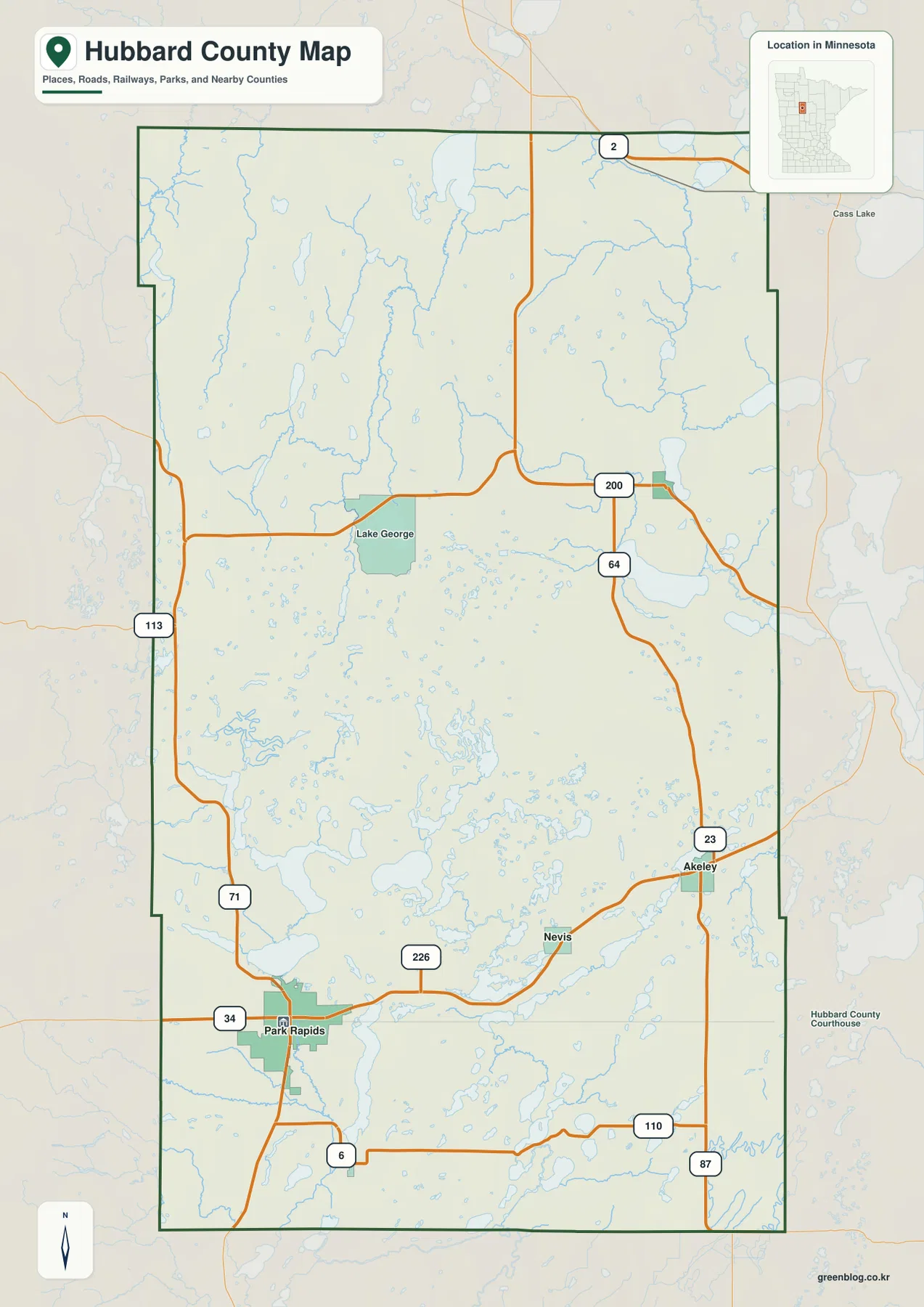
Past Nevis, Highway 34 continues toward Akeley, where Highway 23 provides a north-south connection. Farther north, Highway 64 meets Highway 200, and Highway 200 crosses the interior near Lake George before continuing east. A short segment of Highway 2 appears along the northern edge, creating a separate east-west route well away from the Park Rapids corridor.
Other roads help fill in the edges of the county. Highway 113 enters along the west side, while Routes 110 and 87 appear near the southeast. Highway 6 is visible south of Park Rapids. These routes curve around lakes, wetlands, and river valleys rather than forming a regular grid, so a short straight-line separation on the map does not necessarily mean a short drive.
Direct distances from Park Rapids to Nevis, Akeley, and Laporte
The city-connection map removes most road detail and concentrates on four places. Park Rapids is the hub in the southwest, Nevis lies east of it, Akeley sits farther northeast, and Laporte is substantially farther north. That simplified view makes the long south-to-northeast distribution of the selected communities much easier to see.
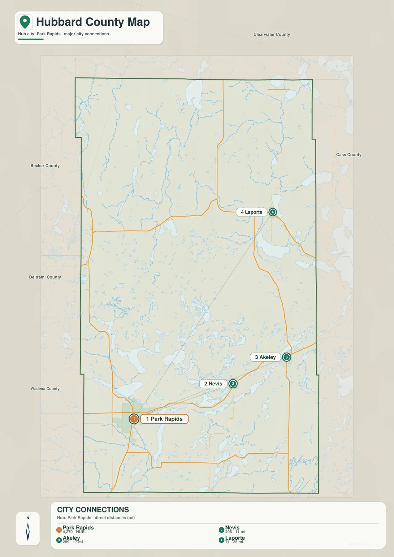
The CITY CONNECTIONS panel lists Park Rapids at 4,270, Nevis at 496, Akeley at 289, and Laporte at 71. It also gives Park Rapids-to-Nevis as 11 miles, Park Rapids-to-Akeley as 17 miles, and Park Rapids-to-Laporte as 25 miles. These are straight-line distances between mapped points, not driving distances. Actual road mileage can be longer because highways bend around water and terrain.
The city numbers should likewise be treated as index values printed on the supplied map rather than as a claim about the latest official population estimates. Their main value is comparative: Park Rapids is shown as the dominant center among the four, while Nevis and Akeley form a smaller eastward sequence and Laporte stands apart in the north.
Minnesota DNR’s Heartland State Trail provides a useful real-world reference for this southern sequence. The trail begins in Park Rapids and continues through the Nevis and Akeley area on its way toward Walker and Cass Lake. That official trail route matches the map’s basic picture of Park Rapids, Nevis, and Akeley as closely connected places across southern Hubbard County.
Schoolcraft, Kabekona, and Necktie rivers in the north
The northern half looks very different on the water map. Schoolcraft River winds through the northwest, Lake Plantagenet occupies the north-central area, and Necktie River is one of the clearer named waterways in the northeast. Across the central-northeastern interior, Kabekona River bends toward Kabekona Lake, giving this part of the county a network of larger named rivers and lakes.
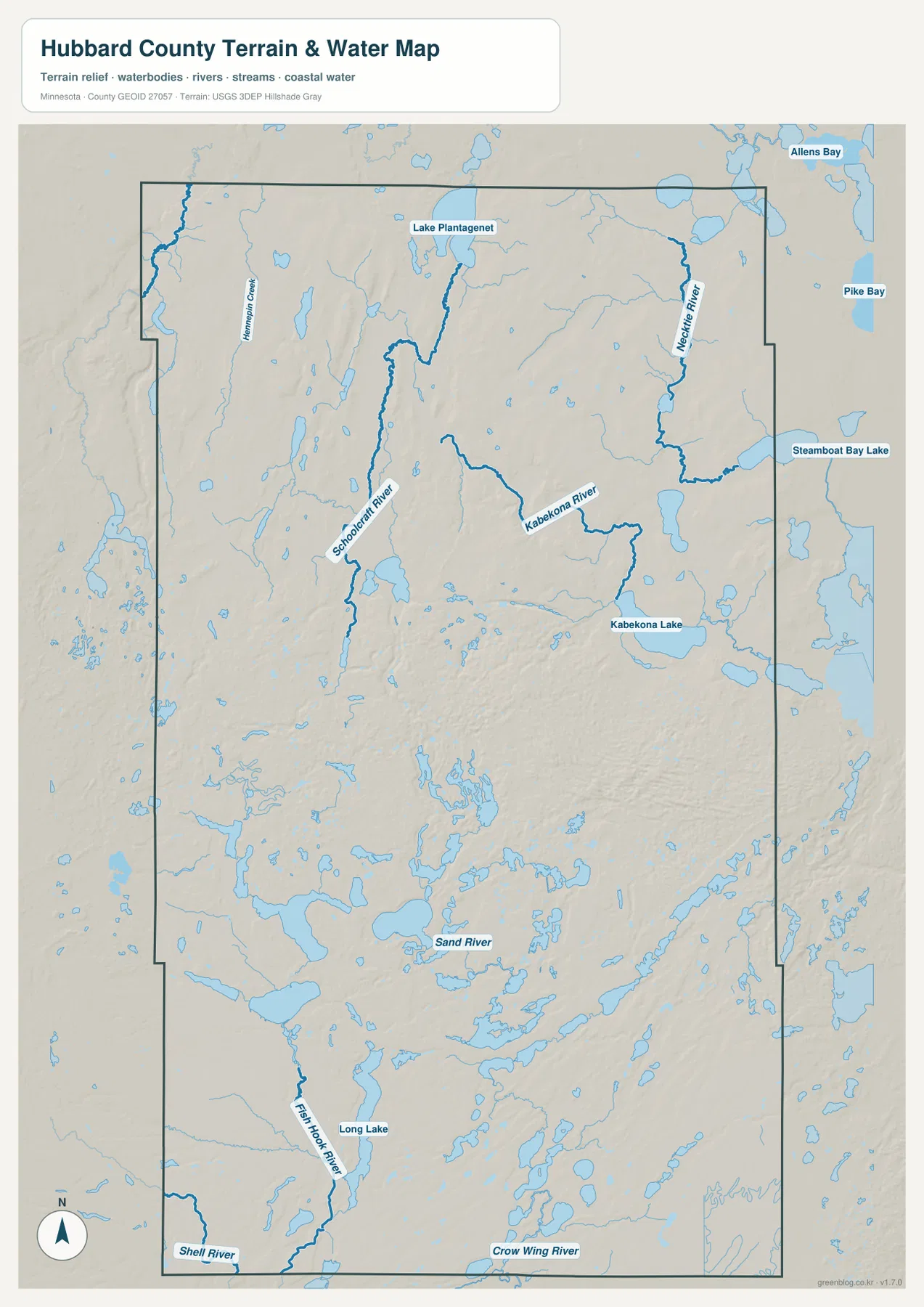
Kabekona Lake is one of the larger labeled water bodies near the east-central side. Steamboat Bay Lake is shown farther north near the eastern boundary, while Allens Bay and Pike Bay appear beyond the county line to the northeast. Those outside labels provide regional context, but they should not be mistaken for lakes entirely inside Hubbard County.
Many smaller lakes and short streams fill the space between the major named waterways. The north is therefore not organized around one single river valley. Instead, water occupies a branching collection of low areas between wooded uplands. Comparing the water view with the road map also helps explain why Highways 200 and 64 bend through the interior rather than crossing it in perfectly straight lines.
Long Lake, Fish Hook River, and the southern lake country
South of the county’s middle, the map becomes much more lake-dense. Long Lake is an important landmark in the southwestern interior, surrounded by many narrower lakes and irregular blue water bodies. Fish Hook River continues through the same general region, while Shell River is labeled separately near the southwestern corner. The two names identify distinct waterways rather than different parts of one river.
Sand River crosses the south-central interior, and Crow Wing River appears along the southern boundary farther east. Around Sand River, small lakes are packed so closely that the general county map’s blue patches become much easier to understand on the water view. The Park Rapids-Nevis-Akeley road corridor runs through genuinely lake-rich terrain, not simply beside one major lake.
This water map is intended for geographic orientation. It does not provide water depth, legal access, private shoreline ownership, flood zones, boating rules, or current fishing regulations. Minnesota DNR, Hubbard County, and federal sources should be used when a decision requires current technical or legal information.
A 395–559 meter range with higher ground across the middle
The supplied elevation map reports an actual range of about 395 to 559 meters, with a mean near 442 meters. The highest brown terrain occupies a broad band through the middle of Hubbard County, including large high areas in the central west and central east. Green terrain becomes more common toward several northern river corridors and parts of the south and southeast.
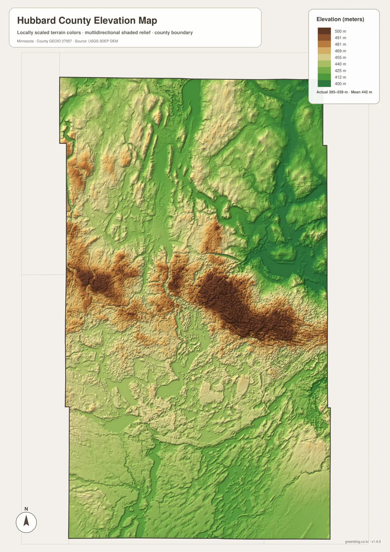
The central high ground is not a single smooth ridge. It breaks into broad hills, lower saddles, narrow drainage channels, and small lake basins. High terrain entering from the west separates into several large areas through the middle, and another broad elevated area occupies the central east. The water map shows many streams and small lakes using the lower gaps between those hills.
Northern Hubbard County is lower overall than the high middle, but it still has substantial local relief. Schoolcraft River, Kabekona River, and Necktie River occupy elongated low areas between rolling higher ground. Around Kabekona Lake, green colors spread more widely, placing the lake basin below much of the terrain immediately to the west and south.
The Park Rapids-Nevis-Akeley area also lies mostly south of the highest central ground. Fish Hook River and the Crow Wing River side follow lower terrain, while hills rise again north of the main southern road corridor. Hubbard County therefore does not simply rise from south to north; the more useful county-wide pattern is a higher middle with lower water-rich areas on both sides.
The elevation surface is designed for broad county comparison, not surveying or engineering. It should not be used for a building elevation, road grade, drainage design, or parcel-level contour decision. Detailed USGS 3D Elevation Program data or a professional survey is the better choice when exact elevations matter.
What the four views reveal about the towns
Park Rapids, Nevis, and Akeley sit largely south of the county’s highest terrain. Their road corridor passes through lower lake country filled with small water bodies and river channels. The principal southern communities are therefore closer to accessible low ground than to the highest central hills, a relationship that becomes obvious only after comparing the road and elevation views.
Laporte has a different setting. It is the farthest selected community from Park Rapids and lies near the Highway 200 and Highway 64 area. On the water map, it is closer to the Kabekona River and Kabekona Lake system; on the elevation map, it sits near the transition from the high central interior toward the lower northeastern lake basin.
Lake George, although not part of the four-city connection diagram, is another useful reference point in the north-central interior. The general map places it near Highway 200 in a more sparsely settled landscape of forest and water. Using Lake George together with Park Rapids and Laporte makes the difference between the developed southern corridor and the quieter northern interior easier to visualize.
Which Hubbard County view fits your task?
Use the general county map when you need roads, boundaries, and a wider set of place names together. The city-connection map is better for a quick comparison of Park Rapids, Nevis, Akeley, and Laporte and for showing the labeled straight-line distances from Park Rapids. Driving routes should still be checked separately.
The water map is the stronger choice for studying Schoolcraft River, Kabekona River, Necktie River, Long Lake, Fish Hook River, Sand River, and the dense field of smaller lakes. Pair it with the elevation map when the goal is to explain how the higher middle of the county separates northern river basins from the southern lake country.
For printing or image editing, the original JPG files in the ZIP provide more resolution than the WebP previews embedded in this article. Each JPG measures 2572 by 3638 pixels, and the archive contains the county, city, water, and elevation maps.
Official sources for more detailed work
Hubbard County’s official government page identifies the county Government Center in Park Rapids, matching the city’s central administrative role and its prominence on the maps. Parcel records, permits, taxes, official road records, and other administrative questions should rely on current county information rather than the overview graphics on this page.
Minnesota DNR’s Heartland State Trail page is useful for the Park Rapids-Nevis-Akeley recreation corridor. U.S. Census Bureau TIGER/Line files support boundary and road work, USGS National Hydrography provides water data, and the USGS 3D Elevation Program is the appropriate source for detailed elevation products. The maps here are intended to make the county’s major geographic relationships easy to understand and reuse.
Frequently Asked Questions
Are the Park Rapids-to-Nevis, Akeley, and Laporte distances road miles?
No. The city-connection map labels 11 miles to Nevis, 17 miles to Akeley, and 25 miles to Laporte from Park Rapids, but those are straight-line distances between mapped points. Actual driving distances can be longer because roads bend around lakes and other terrain.
Where is the highest terrain in Hubbard County?
The supplied elevation map shows an overall range of about 395–559 meters with a mean near 442 meters. The strongest high ground is concentrated through the middle of the county, while several northern river corridors and parts of the southern lake country are lower. Exact site elevations require detailed USGS data or survey information.
How does the northern water system differ from the south?
The north is marked by larger named waterways such as Schoolcraft River, Kabekona River, Necktie River, Lake Plantagenet, and Kabekona Lake. The south contains a denser field of small lakes around Long Lake, Fish Hook River, Sand River, and the Crow Wing River side.
Map File Information
Download the original high-resolution JPG versions of the Hubbard County maps shown on this page in one ZIP file.
- Included Files: county map, city map, water map, elevation map
- Printable Size: each JPG is 2572 × 3638 px
- File Type: ZIP containing 4 JPG files
Related Maps
Sources and references
- Hubbard County Government – county government and Park Rapids Government Center information
- Minnesota DNR Heartland State Trail – trail information for the Park Rapids, Nevis, and Akeley corridor
- U.S. Census Bureau TIGER/Line Shapefiles – boundary, road, and place data
- USGS National Hydrography – river, stream, and water data
- USGS 3D Elevation Program – elevation data and products
Green Map creates custom-edited map images using open geographic data sources such as geoBoundaries, Natural Earth, OpenStreetMap, and government open data. These maps are edited visual materials, not raw data files, and are provided for education, documents, presentations, and graphic reference.