A Guinea Map reveals a country whose shape begins on the North Atlantic coast and reaches far inland across West Africa. Conakry occupies a narrow coastal position in the west, while Kankan and Nzérékoré extend the mapped area toward Guinea’s eastern and southeastern borders. That long west-to-east arrangement makes a visual reference particularly helpful: the capital, regional boundaries, ocean access, and surrounding countries can be understood together instead of as separate facts.
The download set contains three JPG versions arranged for high-resolution A3 use. The color map separates the administrative regions, the black-and-white map retains labels without colored fills, and the outline map removes place names for annotation. Each file presents the same regional framework, allowing a teacher, student, editor, or designer to move between a finished reference image and a clean activity base without changing scale or orientation.
Guinea shares land borders with Guinea-Bissau, Senegal, Mali, Côte d’Ivoire, Liberia, and Sierra Leone. Five of those neighbors are named in the supplied maps; Senegal’s short northwestern boundary is present in the geographic context but its name is not printed. The images also label the North Atlantic Ocean and mark Conakry with a star, which helps distinguish this country from Guinea-Bissau and from Equatorial Guinea farther southeast in Central Africa.
Table of Contents
Guinea Map Overview
The maps show Guinea’s first-level administrative pattern rather than its prefectures. Seven named regions—Boké, Kindia, Labé, Mamou, Faranah, Kankan, and Nzérékoré—occupy the broad areas of the country. Conakry is administered separately as the capital zone and is represented by a coastal star and label because its footprint is too compact to read like the larger inland regions at this national scale.
The western side is visually complex. Boké meets the coast and the Guinea-Bissau border, Kindia surrounds the approach to the capital area, and the shoreline includes small inlets and offshore shapes. Farther inland, Labé and Mamou create a central transition before the wider Faranah and Kankan regions. Nzérékoré forms the southeastern extension between Liberia and Côte d’Ivoire, giving the national silhouette its pronounced lower arm.
This arrangement also connects with Guinea’s four commonly described natural regions: Maritime Guinea, Middle Guinea, Upper Guinea, and Forested Guinea. Those natural zones are not separate boundary layers in the supplied files, so they should not be confused with the seven administrative regions. They can, however, provide a meaningful subject for annotation on the blank version when a lesson compares physical and administrative geography.
Printable Map Styles Included
The three map styles differ in information density rather than geographic coverage. The color version combines regional names, contrasting fills, capital placement, neighboring-country labels, and ocean context. The monochrome version keeps the same reference text with open white regions, while the outline strips the design back to the national silhouette and regional divisions.
These are raster image files, not layered vectors. They can be inserted into documents, presentations, and image-editing projects, and users can draw or type over them in suitable software. However, an individual regional boundary will not behave like a separately selectable SVG path unless the image is traced or rebuilt in a vector application.
Regional Color Map
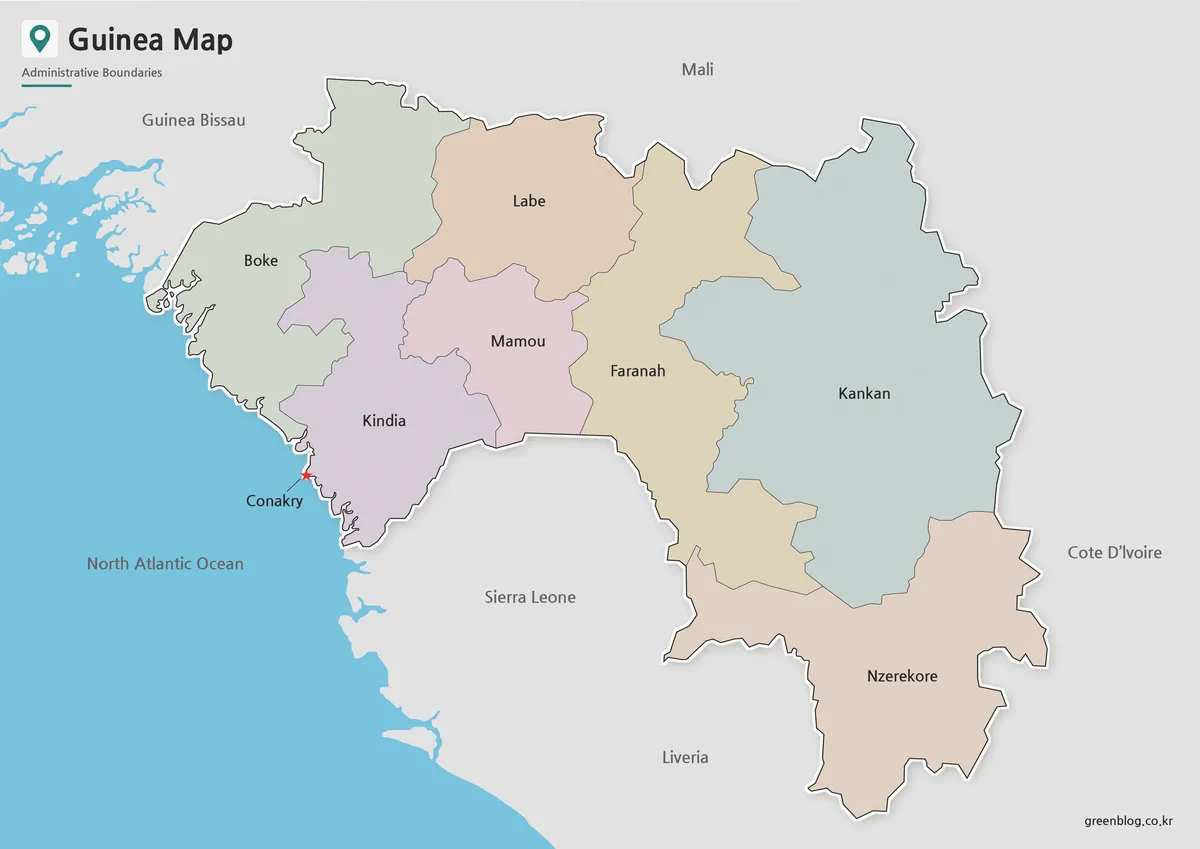
The color Guinea Map makes the irregular meeting points between regions easier to follow. Soft fills separate the coastal Boké and Kindia regions from Labé and Mamou in the center, then continue through Faranah and Kankan to Nzérékoré in the southeast. Because Kankan is broad and angular while Conakry is extremely small at country scale, color and the capital star solve two different reading problems within one image.
The blue Atlantic area immediately identifies the coastal side, and the surrounding land remains gray so Guinea receives the visual emphasis. Labels for Guinea-Bissau, Mali, Sierra Leone, Liberia, and Côte d’Ivoire establish border context without adding the neighbors’ internal divisions. The map spells Côte d’Ivoire without the circumflex in its printed label, a minor typography detail to consider when reusing the image in a formal publication.
This version is the clearest starting point for a slide introducing the country or for a handout that compares Guinea’s western coast with its inland regions. It can also support a sequence explaining how Conakry relates to Kindia and Boké or why Kankan occupies so much of the eastern interior. The restrained palette leaves the dark region names readable on screen.
Black and White Printable Map
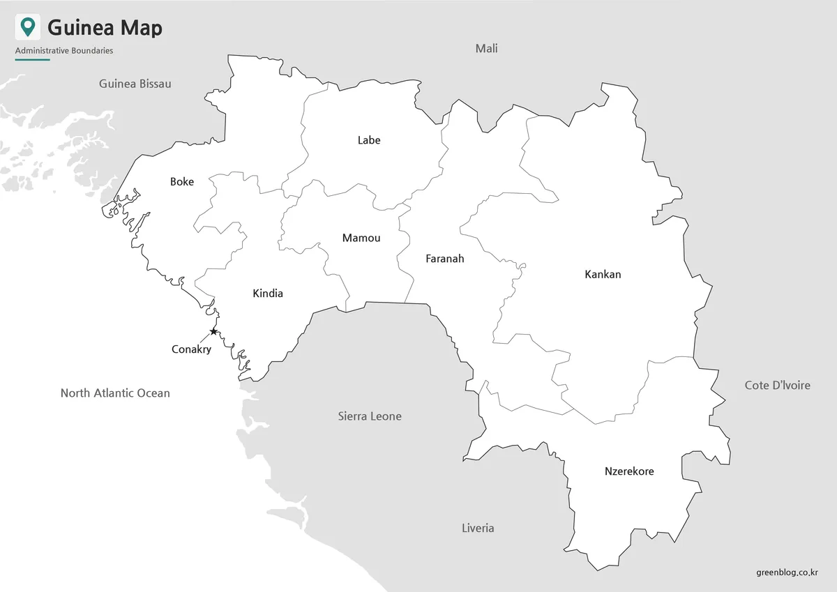
In the monochrome Guinea Map, thin gray lines carry the work previously done by color. Each regional name stays inside its area, while Conakry remains marked on the coast and the neighboring labels remain outside the country. The white interiors provide room for a reader to underline a name, add a number, or apply a simple pencil or marker code after printing.
The coastal details deserve attention when the image is reduced. Boké’s islands and inlets, the star near Conakry, and the Sierra Leone coastline are more delicate than the broad eastern border around Kankan. For an A4 handout or a document column, print a test page or inspect the preview at the final size so these small elements are not lost through aggressive scaling.
Monochrome is a practical choice when the regional names must remain available but the page already contains charts, colored headings, or student annotations. It is also suitable for a comparison packet in which Guinea, Guinea-Bissau, Sierra Leone, and Liberia need a consistent visual treatment. The map is a labeled regional reference, not a road, terrain, or prefecture-level map.
Blank Outline Map for Editing
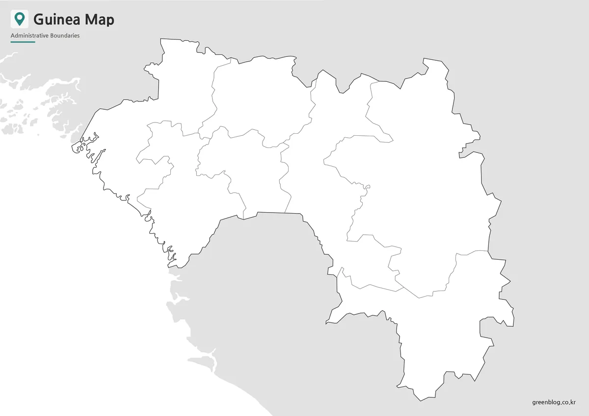
The blank Guinea Map file removes region names, the Conakry marker, neighboring-country names, and ocean text. What remains is Guinea’s outer boundary and the seven large regional divisions, surrounded by simplified coastal context. This reduction turns the image into a worksheet or design base rather than a ready-made reference map.
A student can label Boké and Kindia on the western side, place Labé and Mamou in the center, then identify Faranah, Kankan, and Nzérékoré toward the interior. Another exercise can ask learners to add Conakry on the coast and draw arrows toward all six neighboring countries. These tasks use the unusual shape of Guinea rather than relying on generic coloring instructions.
For infographic work, the open regions can carry category colors, short values, symbols, or a custom legend. A project about the four natural regions can overlay its own grouped colors, provided the designer explains that the supplied internal lines represent administrative areas. Since the source is a JPG image, detailed recoloring may require selection tools and should not be described as direct vector editing.
Why This Map Is Useful
The Guinea Map is especially valuable for resolving name and location confusion. Guinea-Bissau is a separate neighboring country immediately northwest of Guinea, while Equatorial Guinea lies much farther southeast on the Gulf of Guinea and does not share a border. Placing Conakry, the Atlantic coast, and Guinea-Bissau in one frame provides a visual distinction that country names alone cannot supply.
It also shows how a coastal capital can sit at one end of a country with substantial inland extent. A reader can trace the route of the national shape from Conakry and Kindia through Mamou and Faranah toward Kankan, then down to forested Nzérékoré. That directional structure is relevant to lessons about regional position, border relationships, and the contrast between coastal and interior areas.
The layout was organized to enlarge Guinea while retaining just enough of the surrounding coast and neighboring land for orientation. This choice makes the regional labels easier to read than they would be on a small West Africa overview. It also means the map should be paired with a continent map when a reader needs to see Guinea’s position relative to all of Africa.
Practical Uses for the Guinea Map
Choose the color version when an audience must recognize the seven regions quickly, especially on a classroom screen or introductory slide. Use the labeled monochrome version for reports, revision sheets, and assignments where names are needed but color would compete with other information. Select the outline when the reader will supply the labels, classify regions, or build a custom thematic graphic.
For A3 printing, keep the original aspect ratio and use the printer’s fit-to-page control rather than stretching the image. A borderless setting may enlarge the map, but a normal margin helps protect the title, coastal details, and text near the right edge. When reducing the file to A4, inspect the Conakry star and the small western coastline before producing a full class set.
The files can also be used together as a short learning sequence. Present the color reference first, ask students to review the same names on the monochrome sheet, and then use the outline for recall. A design workflow can reverse that order by starting with the blank base, adding a specific theme, and checking the labeled map to confirm regional placement.
Frequently Asked Questions
What is included in this Guinea Map collection?
The collection includes a color regional map, a black and white printable map, and a blank outline map.
Can I print the Guinea Map in A3 size?
Yes. The layout was prepared with A3-size printing in mind.
Which version is best for classroom handouts?
The black and white map is usually the best choice for worksheets, reports, and printed study materials.
Is the outline map editable?
Yes. The blank outline version is suitable for coloring, labeling, annotations, and infographic editing.
Download Information
Map File Information
The archive provides three Guinea regional map images for reference, monochrome printing, and custom annotation.
- Included Versions: Color regional, labeled black and white, blank outline
- Printable Size: A3 High Resolution
- File Type: JPG
- Intended Use: Lessons, worksheets, presentations, reports, and image-based editing
Related Maps
Additional Resources
- Presentation of Guinea — Read an official French-language overview of the country’s four natural regions, climate, and major geographic characteristics.
Green Map creates custom-edited map images using open geographic data sources such as geoBoundaries, Natural Earth, OpenStreetMap, and government open data.
These maps are edited visual materials, not raw data files, and are provided for education, documents, presentations, and graphic reference.