A Humboldt County Nevada Map is useful for understanding a large piece of northern Nevada that stretches from Winnemucca to the Oregon line. I-80 and U.S. 95 meet near the county’s main city, while Orovada, Paradise Valley, and Fort McDermitt mark the long northern corridor. Separate water and elevation views show the Humboldt and Quinn river systems, scattered lakes and reservoirs, and the repeating mountain-and-basin terrain. The WebP previews are designed for quick reading, and the same four maps can be downloaded below as high-resolution JPG files in one ZIP archive. High-resolution map files are available for download in the section below.
Humboldt County is easier to understand as a set of valleys divided by mountain ranges than as one continuous plain. Winnemucca occupies the busy southeastern transportation corridor, but much of the county is rural and lightly settled. The Humboldt River crosses lower country near Winnemucca, while the Quinn River system and numerous reservoirs occupy northern and western basins. The road, city, water, and elevation maps each reveal a different part of that geography.
Table of Contents
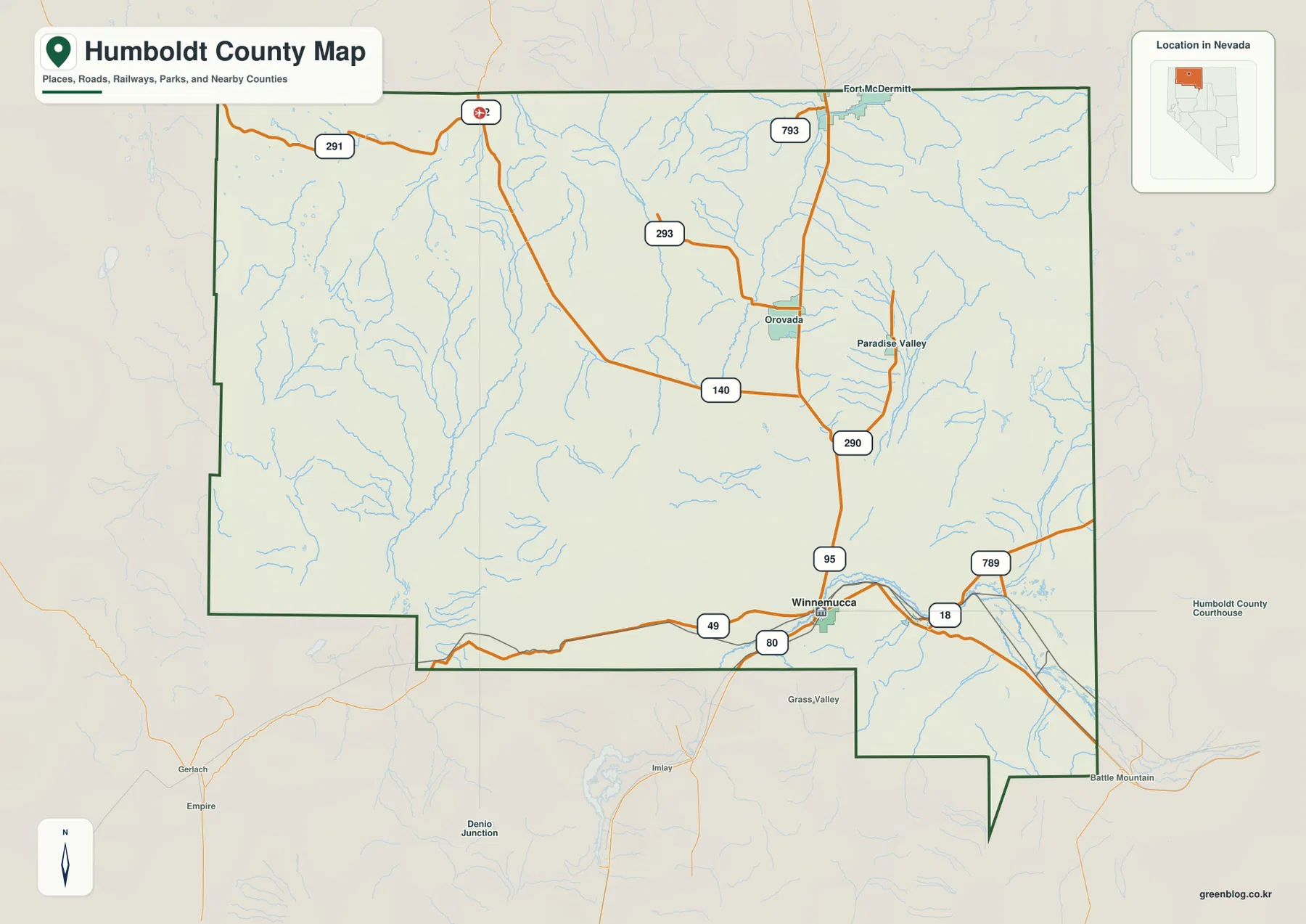
Winnemucca links I-80 with U.S. 95 and the northern valleys
Winnemucca is the clearest anchor on the general county map. I-80 provides the main east-west route, and U.S. 95 turns north through Orovada toward Fort McDermitt at the Oregon line. Their intersection gives Winnemucca a transportation role that is much larger than the city’s footprint, especially for travelers and freight moving between northern Nevada and southeastern Oregon.
Nevada 140 leaves the U.S. 95 corridor toward broad western basins, while 290 serves Paradise Valley. Routes 293 and 291 continue into northern mountain-and-ranch country, and 793 appears near the Fort McDermitt side. Around the southeast, routes 789 and 18 branch near Winnemucca, with 49 extending west along the southern edge. The pattern shows major highways feeding long local corridors rather than a dense countywide grid.
Nevada law records Humboldt County as an original 1861 county and identifies Winnemucca as the county seat after the seat was moved there in 1873. Travel Nevada describes Winnemucca as a community shaped by the Humboldt River, the transcontinental railroad era, ranching, and later mining. The modern highway layout still reflects that same strategic location along a major east-west corridor.
This map is intended for regional orientation rather than live navigation. Winter weather, unpaved roads, wildfire restrictions, and remote access can change quickly. Its strength is showing how Winnemucca connects to the Oregon line and how the numbered state routes enter separate valleys around Orovada, Paradise Valley, and the western interior.
One ranked city in a county of long rural distances
The city-distribution panel contains only one ranked major city: Winnemucca. Orovada, Paradise Valley, Fort McDermitt, and other named places are important geographic references, but they do not appear as additional ranked city points. That simple panel makes the county’s settlement pattern obvious—services and urban development are concentrated around Winnemucca while most of the jurisdiction remains rural.
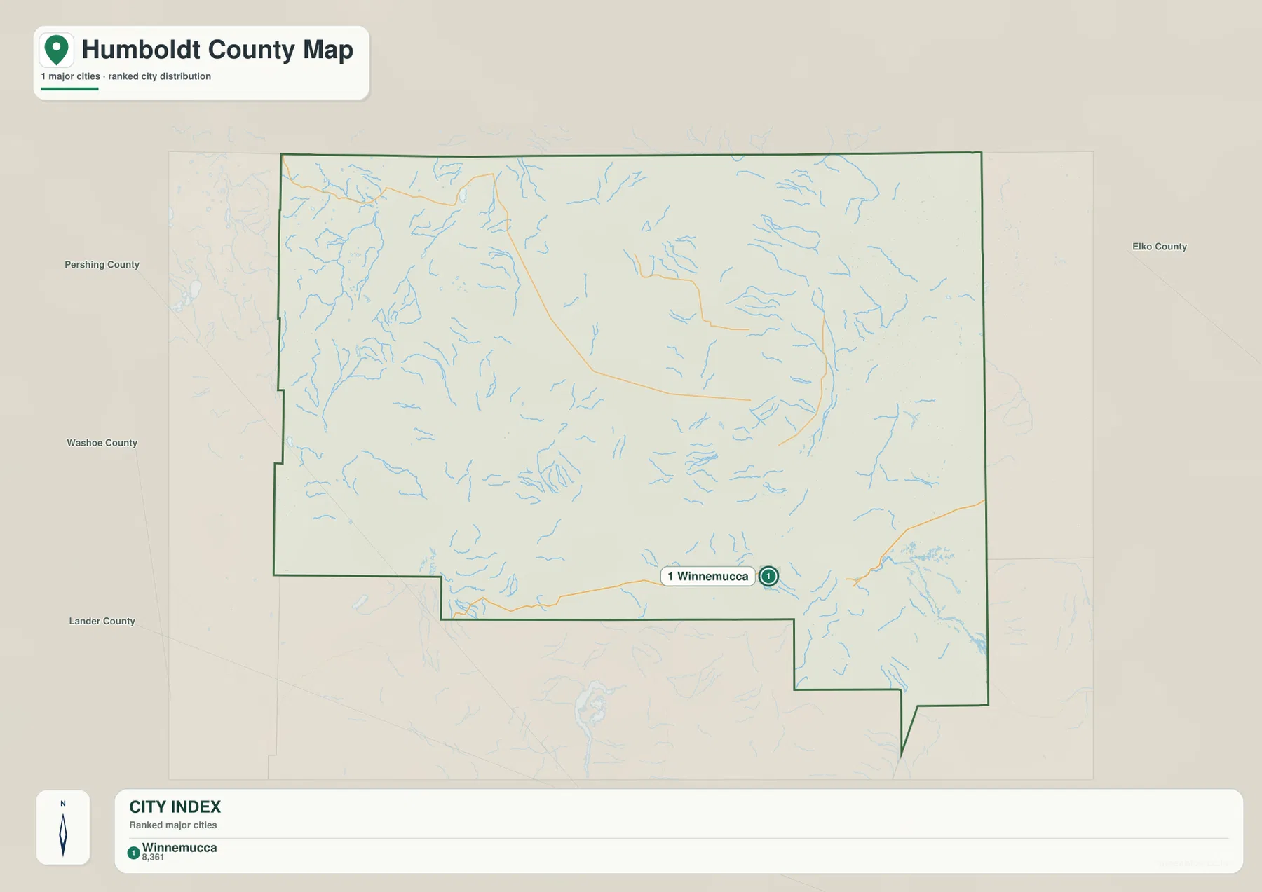
Because the city graphic contains no distance connectors, it should not be used to invent mileage from Winnemucca to Orovada, Paradise Valley, or Fort McDermitt. Actual driving distance follows U.S. 95 and local valley roads and should come from current route information. The useful message here is concentration rather than mileage.
Winnemucca sits in comparatively low country along the Humboldt River and has far more road access than the northern and western interior. As the general map spreads away from the city, community labels become sparse while mountain ranges and drainage lines become more important. The city map therefore works best when read together with the terrain and water views.
Humboldt and Quinn river systems occupy separate basin networks
The southeastern water map is anchored by the Humboldt River near Winnemucca. Little Humboldt River occupies lower country farther east, while East Fork Quinn River appears in the northeastern mountains. These streams do not form one simple countywide drainage pattern because parallel mountain ranges divide neighboring valleys into different watersheds.
Quinn River crosses the northwestern-central interior, and Wash Creek is labeled farther west. Summit Lake sits near the western mountain country, while Big Spring Reservoir, Continental Lake, Gridley Lake, and Knott Creek Reservoir are scattered across the northwest. Bilk Creek Reservoir occupies the north-central side, and Chimney Reservoir provides a water reference in the east.
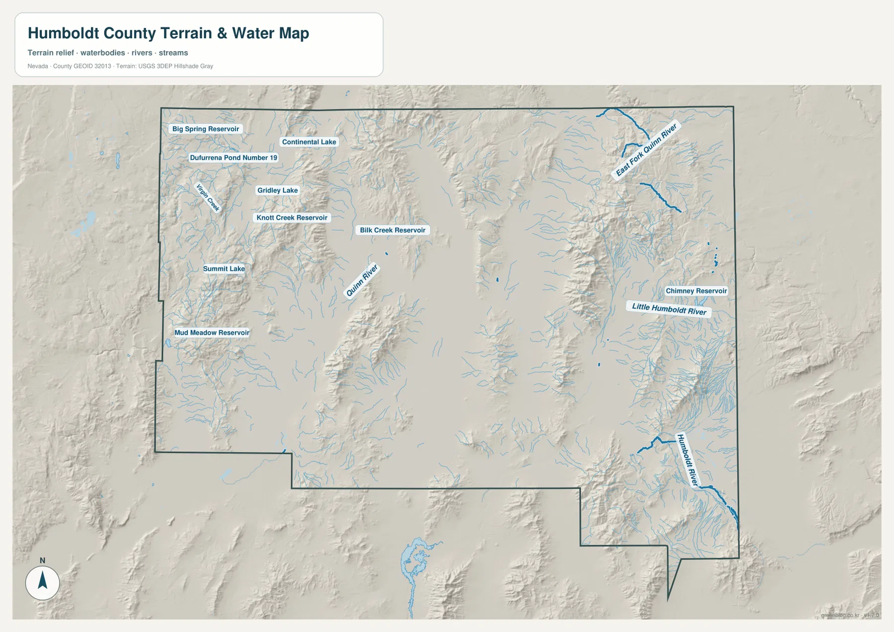
Mud Meadow Reservoir appears in the west-central low country, and Dufurrena Pond Number 19 is another named water feature in the northwest. Across the map, short creeks descend from mountain fronts into separate valleys rather than joining a single dominant river. That pattern is characteristic of the dry basin-and-range landscape of northern Nevada.
Blue stream lines and water colors are symbolic rather than measurements of discharge, depth, flood risk, or reservoir level. Conditions can vary with season and management. Use current USGS and managing-agency information for fishing, boating, flood, water-quality, and access decisions.
Valleys near 1,151 meters lie below ranges reaching 2,918 meters
The elevation map makes the county’s basin-and-range structure unmistakable. The displayed surface runs from about 1,151 to 2,918 meters, with a mean near 1,549 meters. Broad valley floors appear in dark green, while narrow brown mountain ranges rise repeatedly across the west, north, center, and east.
Several western and northwestern ranges stand sharply above neighboring basins, and a long north-central ridge separates major valley systems. In the east, lower corridors around Little Humboldt River and East Fork Quinn River are enclosed by higher mountain blocks. Winnemucca sits in lower southeastern terrain, but higher relief begins quickly outside the main valley.
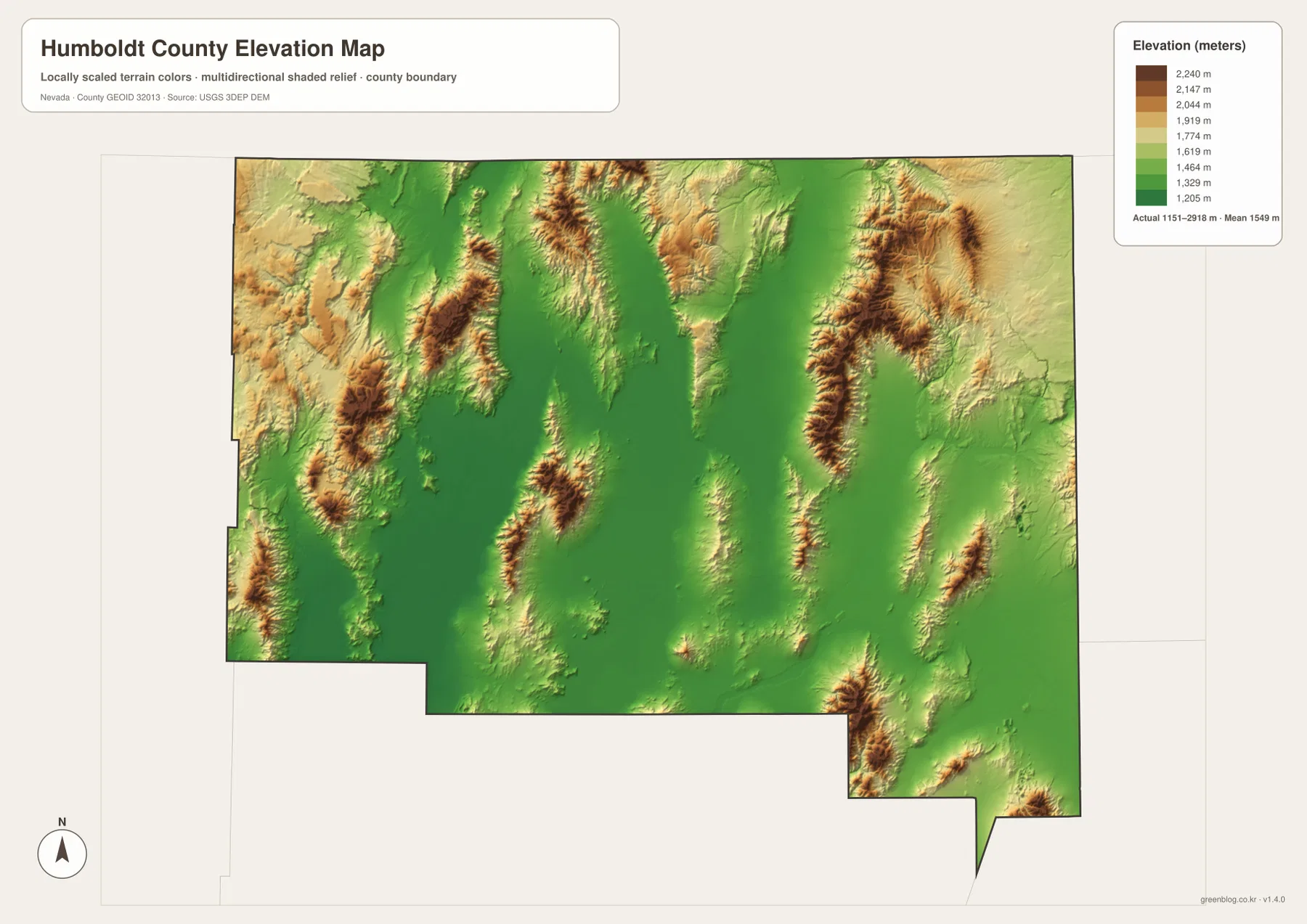
Paradise Valley and the Orovada side occupy lower corridors between surrounding mountains rather than flat open country without relief. Around Summit Lake and the western reservoirs, the terrain is similarly divided into individual basins. The elevation view explains why roads and streams often follow long narrow valleys instead of taking direct routes across the county.
This generalized elevation surface is intended for county-scale comparison, not surveying, mine planning, or engineering. Exact parcel elevation, mountain-road grade, construction benchmarks, and safety decisions require appropriate USGS source data, current field information, or professional surveying.
Water Canyon and the Winnemucca Sand Dunes show two sides of the local landscape
Two BLM sites near Winnemucca illustrate how quickly the landscape changes around the county seat. Water Canyon Recreation Area rises almost 2,000 feet above the town and combines rugged upper slopes with a greener riparian corridor of cottonwood and aspen along the canyon bottom. That steep transition matches the elevation map, where low valley terrain gives way quickly to nearby mountain relief.
North of Winnemucca along U.S. 95, the Winnemucca Sand Dunes represent a very different environment. The Bureau of Land Management describes them as Nevada’s largest dune field. Individual dunes are relatively low, but the dune complex extends roughly 20 miles east to west across a mix of public and private land.
Anyone planning to visit either area should check current BLM access, wildfire, and road information first. The county maps on this page are designed for regional context rather than campsite, trail, OHV, or private-property navigation. They are most useful for seeing how these recreation landscapes relate to Winnemucca, U.S. 95, nearby mountain fronts, and the broader county.
A practical order for comparing roads, rivers, and relief
Start with the general map by locating Winnemucca and the I-80–U.S. 95 junction, then trace the northern route through Orovada toward Fort McDermitt and the Paradise Valley side roads. The city panel provides a simpler second view because it contains only Winnemucca as a ranked major city.
For physical geography, compare the Humboldt River in the southeast with Little Humboldt River and the Quinn River system farther north and west. The elevation map then shows why these waterways separate: long mountain ranges divide the county into individual valleys, while reservoirs and lakes occupy selected low basins.
The high-resolution JPG files are more convenient for printing and for zooming into smaller road, stream, lake, and reservoir labels than the on-page WebP previews. They remain reference maps rather than legal boundary, parcel, flood, navigation, mine-planning, or engineering products. For technical use, compare them with current Census, USGS, BLM, and relevant local or state data.
Frequently Asked Questions
Does the city map show a distance from Winnemucca to Orovada or Paradise Valley?
No. Winnemucca is the only ranked major city on the supplied city panel, and there are no connector lines or mileage values. Actual travel distance to Orovada, Paradise Valley, or Fort McDermitt should be checked with current road routing.
Do the Humboldt and Quinn rivers belong to one simple drainage system?
No. Humboldt County contains several mountain-divided basins. The Humboldt River occupies the southeastern side near Winnemucca, while Quinn River and related streams drain different northern and western valleys.
Can the 1,151–2,918 meter elevation range be used for surveying?
No. Those values describe a generalized county-scale elevation surface. Exact site elevations, road grades, mine or construction benchmarks, and engineering work require appropriate USGS source data or professional surveying.
Map File Information
Download the four high-resolution JPG maps shown on this page for Humboldt County in one ZIP archive.
- Included Files: Use only the versions confirmed in the article and supplied images
- File Type: Use the confirmed download contents
- Intended Use: Printing, education, presentations, and map-based projects
Related Maps
Sources and references
County creation and the Winnemucca county seat are supported by Nevada Legislature records. Winnemucca history comes from Travel Nevada, while Water Canyon and Winnemucca Sand Dunes information comes from the Bureau of Land Management. The federal sources below provide authoritative boundary, hydrography, and elevation references.
- Nevada Legislature – Humboldt County Creation and County Seat
- Travel Nevada – Winnemucca
- Bureau of Land Management – Water Canyon Recreation Area
- Bureau of Land Management – Winnemucca Sand Dunes
- U.S. Census Bureau – TIGER/Line Shapefiles
- USGS – National Hydrography
- USGS – 3D Elevation Program
Green Map creates custom-edited map images using open geographic data sources such as geoBoundaries, Natural Earth, OpenStreetMap, and government open data. These maps are edited visual materials, not raw data files, and are provided for education, documents, presentations, and graphic reference.