A Clark County Nevada Map has to capture more than the Las Vegas metropolitan area. Clark County also includes Lake Mead and the Colorado River, the high Spring Mountains west of the city, the Virgin and Muddy river country in the northeast, and a long desert corridor toward the southern tip of Nevada. These maps show major cities and roads, water and terrain, and a dramatic elevation range in separate views. The WebP previews are optimized for quick reading, while the same four maps can be downloaded below as high-resolution JPG files in one ZIP archive. High-resolution map files are available for download in the section below.
Las Vegas Valley contains the county’s densest urban and road network, but it occupies only part of the jurisdiction. Henderson and North Las Vegas form major neighboring cities, Boulder City sits near Lake Mead, and Mesquite is far to the northeast near the Virgin River. Beyond those centers, broad desert basins, washes, isolated ranges, and federal recreation lands dominate the map. Seeing the city, water, and elevation views together prevents Clark County from being reduced to a single urban image.
Table of Contents
I-15 and U.S. 95/93 converge on the Las Vegas Valley
The general county map is most detailed around Las Vegas, North Las Vegas, Paradise, Spring Valley, Enterprise, and Henderson. I-15 runs north-south through the valley, continuing toward Mesquite and Utah in one direction and California in the other. U.S. 95 and U.S. 93 provide major routes toward Indian Springs, the northern desert, and the Moapa Valley side of the county.
State routes 156 and 157 climb into the Mount Charleston and Spring Mountains area, while 159 and 160 serve the western and southwestern side of the metropolitan basin. In the northeast, routes 168 and 169 connect Moapa Town, Moapa Valley, and approaches toward Lake Mead and Mesquite. Route 165 continues south of Boulder City, and 163 crosses the far southern county toward Laughlin and the Colorado River.
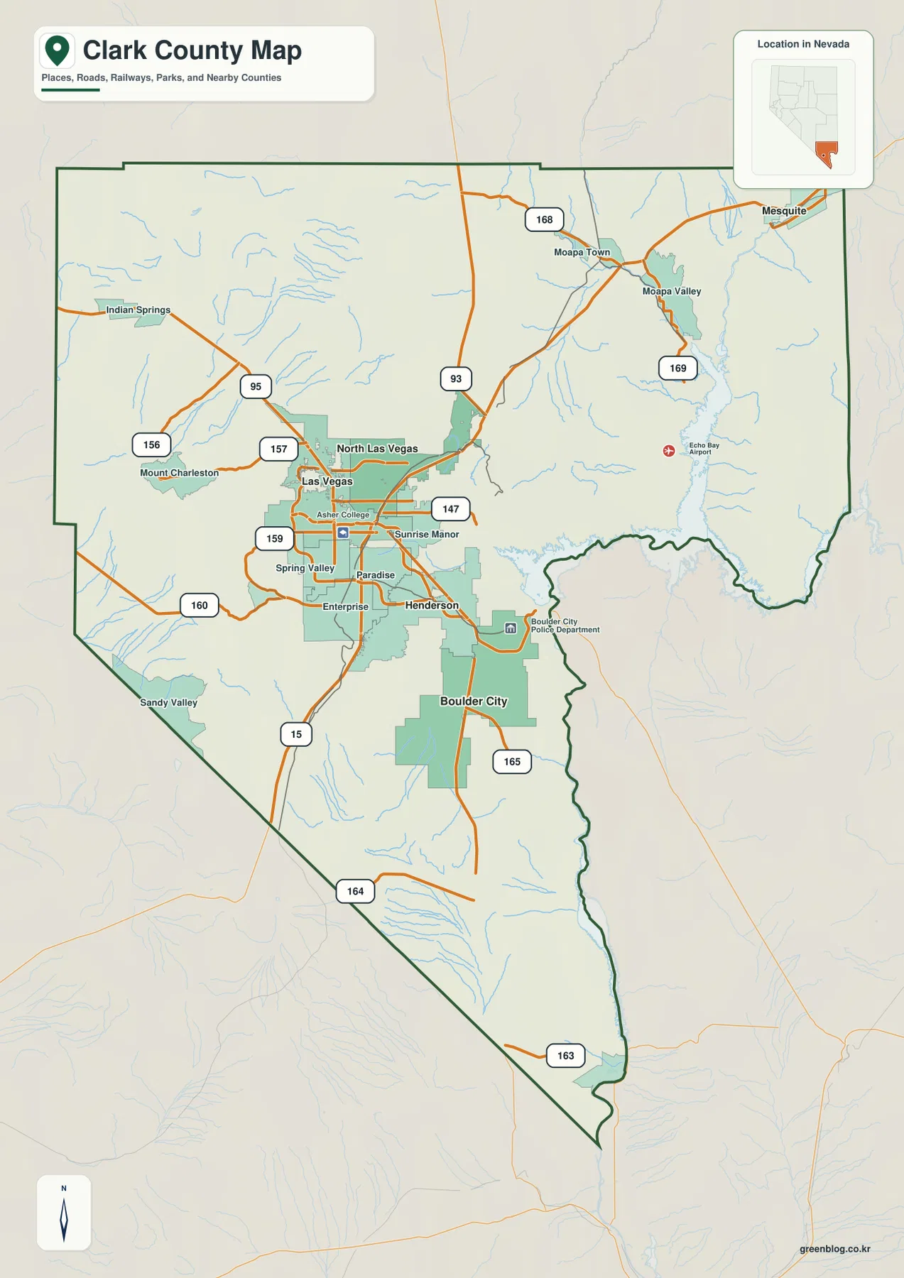
Clark County was created from Lincoln County in 1909, with Las Vegas selected as the county seat. The county’s official history also points out an administrative detail that is easy to miss on tourist maps: much of the Las Vegas Strip lies in unincorporated Clark County rather than within the City of Las Vegas. Labels such as Paradise and Spring Valley therefore matter when reading the metropolitan portion of the county map.
This static map is useful for orientation rather than turn-by-turn navigation. Interchanges, construction, and desert-road conditions can change. Its strength is showing where the metropolitan road grid gives way to long desert corridors and how routes toward Mount Charleston, Mesquite, Boulder City, and the southern Colorado River area relate to the central valley.
Five major cities, with three concentrated in one metropolitan basin
The ranked city panel lists Las Vegas first, followed by Henderson, North Las Vegas, Mesquite, and Boulder City. The first three occupy the Las Vegas Valley and form a tight metropolitan cluster. Mesquite is separated far to the northeast, while Boulder City lies southeast of the main urban core beside the Lake Mead corridor.
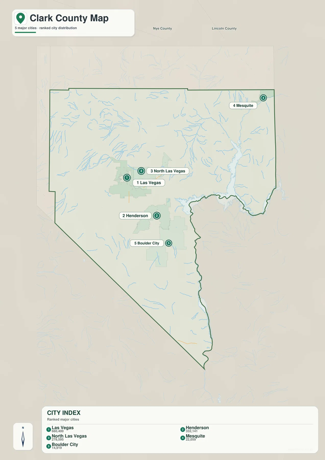
The city panel contains no connector lines or mileage table, so it should not be used to invent straight-line or driving distances. Current routing is the right source for travel time between Las Vegas, Mesquite, Boulder City, or other destinations. The useful message from this graphic is concentration: the county’s largest urban centers occupy a relatively small part of a much larger desert jurisdiction.
That difference becomes clearer when the city and general maps are compared. Clark County contains incorporated cities, large unincorporated communities, mountain recreation areas, lake shore, and broad open desert. The administrative map therefore covers far more than what visitors usually mean by “Las Vegas,” even though the valley remains the dominant population and service center.
Virgin and Muddy rivers feed Lake Mead and the Colorado River corridor
Lake Mead and the Colorado River dominate the terrain-and-water map. Lake Mead spreads across the eastern side of Clark County, while the Colorado River continues south through a narrower valley that helps define the Nevada-Arizona boundary. In the northeast, the Virgin River approaches from the Mesquite side and the Muddy River descends through the Moapa Valley toward the northern arms of Lake Mead.
California Wash and Valley of Fire Wash join the Muddy River side, while numerous shorter desert washes descend from nearby ranges. Closer to Las Vegas, the map labels Duck Creek, W Sahara Lake, and Lake Las Vegas. Cold Creek and Deer Creek appear in the northwest near the Spring Mountains, and Searles Reservoir provides another local water reference in the interior.
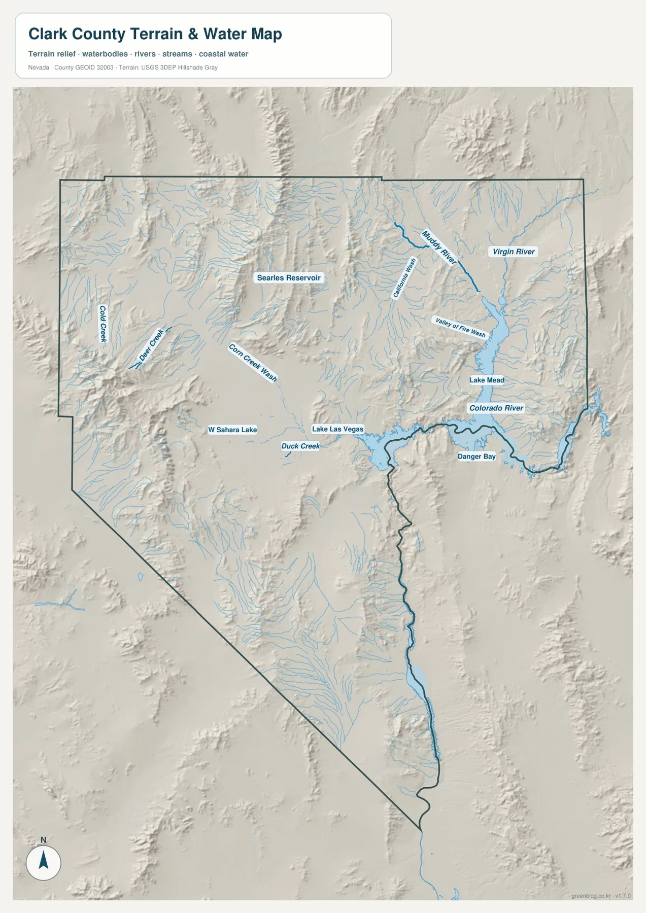
The National Park Service describes Lake Mead National Recreation Area as a 1.5-million-acre landscape of mountains, canyons, valleys, and the large Lake Mead and Lake Mohave reservoirs. On the county map, the Nevada side of Lake Mead occupies a major portion of the eastern landscape and provides an immediate contrast with the heavily urbanized Las Vegas Valley to the west.
Blue stream lines and water colors are symbolic rather than measurements of flow, depth, or flood hazard. Lake levels and launch conditions can also change. Use current National Park Service, USGS, and local information for boating, fishing, flood, water-quality, or access decisions.
A 146-to-3,595-meter rise from the Colorado River to the Spring Mountains
The elevation map reveals an extraordinary range within one county. The displayed surface runs from about 146 to 3,595 meters, with a mean near 1,007 meters. The Lake Mead and Colorado River side appears in deep green at low elevation, while the Spring Mountains and Mount Charleston area west of Las Vegas rise into brown and dark-brown high country.
Las Vegas Valley occupies intermediate terrain between the western mountain wall and lower eastern basins. Routes 156 and 157 climb into the Spring Mountains along valleys that are easy to match between the road and elevation maps. In the opposite direction, Henderson and Boulder City descend toward Lake Mead, and the far southern county continues along low Colorado River country between surrounding ranges.
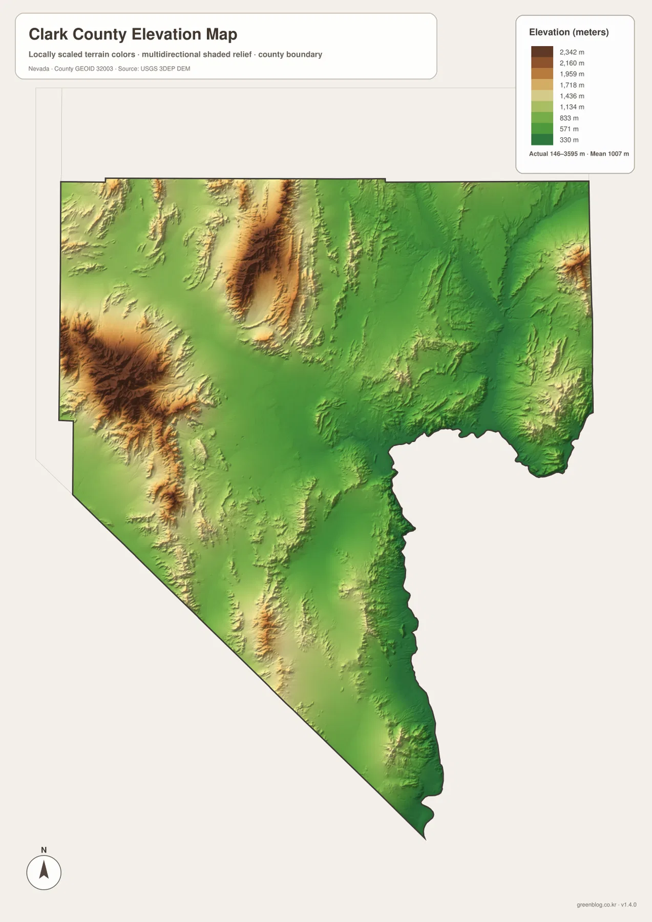
The north and northeast are also strongly broken by ranges and valleys. Moapa Valley and the Mesquite side occupy lower corridors between higher ridges, while washes descend toward Lake Mead. The long southern extension repeats the same pattern on a narrower scale. Clark County may be best known for an urban basin, but its physical geography is a repeated sequence of mountains, desert valleys, canyons, and water corridors.
This generalized elevation surface is intended for county-scale comparison, not surveying or engineering. Exact parcel elevation, mountain-road grade, construction benchmarks, and safety decisions require appropriate USGS source data, current route information, or professional surveying.
Red Rock Canyon and Mount Charleston rise beside the metropolitan area
The western edge of Las Vegas Valley changes rapidly from urban streets to protected desert cliffs and high mountains. The Bureau of Land Management places Red Rock Canyon National Conservation Area about 17 miles west of the Las Vegas Strip on State Route 159. Its red and cream sandstone escarpments, hiking routes, climbing areas, and scenic drive occupy the same western transition that appears as stronger relief on the county maps.
Farther northwest, Mount Charleston and the Spring Mountains contain the highest terrain in Clark County. The elevation view makes the rise unmistakable, and the general road map shows state routes 156 and 157 entering the mountain valleys. The short geographic distance between the Las Vegas Valley floor and this much higher country is one of the county’s most distinctive physical contrasts.
The eastern side offers a very different landscape. Boulder City and Lake Mead sit in lower desert terrain, while the Moapa Valley and Mesquite side connects to the Virgin and Muddy rivers. In one county, readers can compare a dense metropolitan basin, sandstone escarpments, alpine-height mountains, major reservoirs, and the Colorado River corridor.
A practical sequence for comparing the urban valley with the outer county
Start with the general county map by finding Las Vegas, Henderson, and North Las Vegas and then tracing I-15 and U.S. 95/93 away from the valley. Mesquite, Moapa Valley, Boulder City, and Mount Charleston provide useful outer reference points. The ranked city panel then simplifies the settlement picture by showing how strongly the five major cities are concentrated in only a few parts of the county.
For physical geography, locate Lake Mead and the Colorado River first, then follow the Virgin and Muddy rivers into the northeast. The elevation map completes the comparison by showing how the low river-and-reservoir country contrasts with the Spring Mountains and Mount Charleston in the west. Together, the water and elevation views make the county’s large relief differences much easier to understand.
The high-resolution JPG files are more convenient for printing and for zooming into smaller road and water labels than the on-page WebP previews. They remain reference maps rather than legal boundary, parcel, flood, navigation, or engineering products. For technical use, compare them with current U.S. Census Bureau, USGS, National Park Service, and relevant local data.
Frequently Asked Questions
Is the entire Las Vegas Strip inside the City of Las Vegas?
No. Clark County’s official information explains that much of the Strip lies in unincorporated Clark County rather than inside the City of Las Vegas. That is why places such as Paradise and Spring Valley appear as separate labels around the metropolitan core.
Where are Lake Mead and the Colorado River on the county map?
Lake Mead occupies a large part of eastern Clark County, and the Colorado River continues south from the reservoir through the southeastern and southern county. Boulder City is the main city reference west of Lake Mead, while the Virgin and Muddy rivers approach from the northeast.
Can the 146–3,595 meter elevation range be used for surveying?
No. Those values describe a generalized county-scale elevation surface. Exact parcel elevations, construction benchmarks, road grades, and engineering work require appropriate USGS source data or professional surveying.
Map File Information
Download the four high-resolution JPG maps shown on this page for Clark County in one ZIP archive.
- Included Files: Use only the versions confirmed in the article and supplied images
- File Type: Use the confirmed download contents
- Intended Use: Printing, education, presentations, and map-based projects
Related Maps
Sources and references
County formation, the Las Vegas county seat, and unincorporated Clark County background come from official Clark County information. Lake Mead context comes from the National Park Service and Red Rock Canyon from the Bureau of Land Management. The federal sources below provide authoritative boundary, hydrography, and elevation references.
- Clark County – About Clark County
- National Park Service – Lake Mead National Recreation Area
- Bureau of Land Management – Red Rock Canyon National Conservation Area
- U.S. Census Bureau – TIGER/Line Shapefiles
- USGS – National Hydrography
- USGS – 3D Elevation Program
Green Map creates custom-edited map images using open geographic data sources such as geoBoundaries, Natural Earth, OpenStreetMap, and government open data. These maps are edited visual materials, not raw data files, and are provided for education, documents, presentations, and graphic reference.