A Lincoln County Nevada Map is useful for a county where towns, highways, wetlands, and mountain valleys are spread over a large area of southeastern Nevada. U.S. 93 links Alamo, Hiko, Caliente, and the Panaca-Pioche area, while state routes branch toward western basins, Utah, and narrow canyon country. Separate water and elevation views show Pahranagat Lakes, Meadow Valley Wash, Echo Canyon Reservoir, and a relief range from low southern valleys to high northern mountains. The WebP previews are designed for quick viewing, and the same four maps can be downloaded below as high-resolution JPG files in one ZIP archive. High-resolution map files are available for download in the section below.
Lincoln County is not organized around one continuous urban corridor. Caliente forms the only ranked major city on the supplied city panel, while Panaca and Pioche sit to the north and Alamo and Hiko occupy the Pahranagat Valley farther south. Between those communities are long stretches of mountain-and-basin terrain, so the road, water, and elevation maps are essential for understanding how the county fits together.
Table of Contents
U.S. 93 links the Pahranagat Valley with Caliente and Panaca
U.S. 93 is the clearest north-south reference on the general county map. It enters from the Clark County side, passes Alamo and Hiko, and continues toward Caliente, Panaca, and the White Pine County direction. In a county divided by long ranges, the highway generally follows lower corridors rather than cutting directly across the highest terrain.
Near Hiko, Nevada 375 branches west toward Nye County, while Nevada 318 runs north through another long valley. From the Panaca side, Route 319 heads east toward Utah, and Route 317 follows the Meadow Valley corridor south of Caliente. Shorter roads around Pioche include routes 320 and 322, adding local access to the county-seat area and nearby mountain basins.
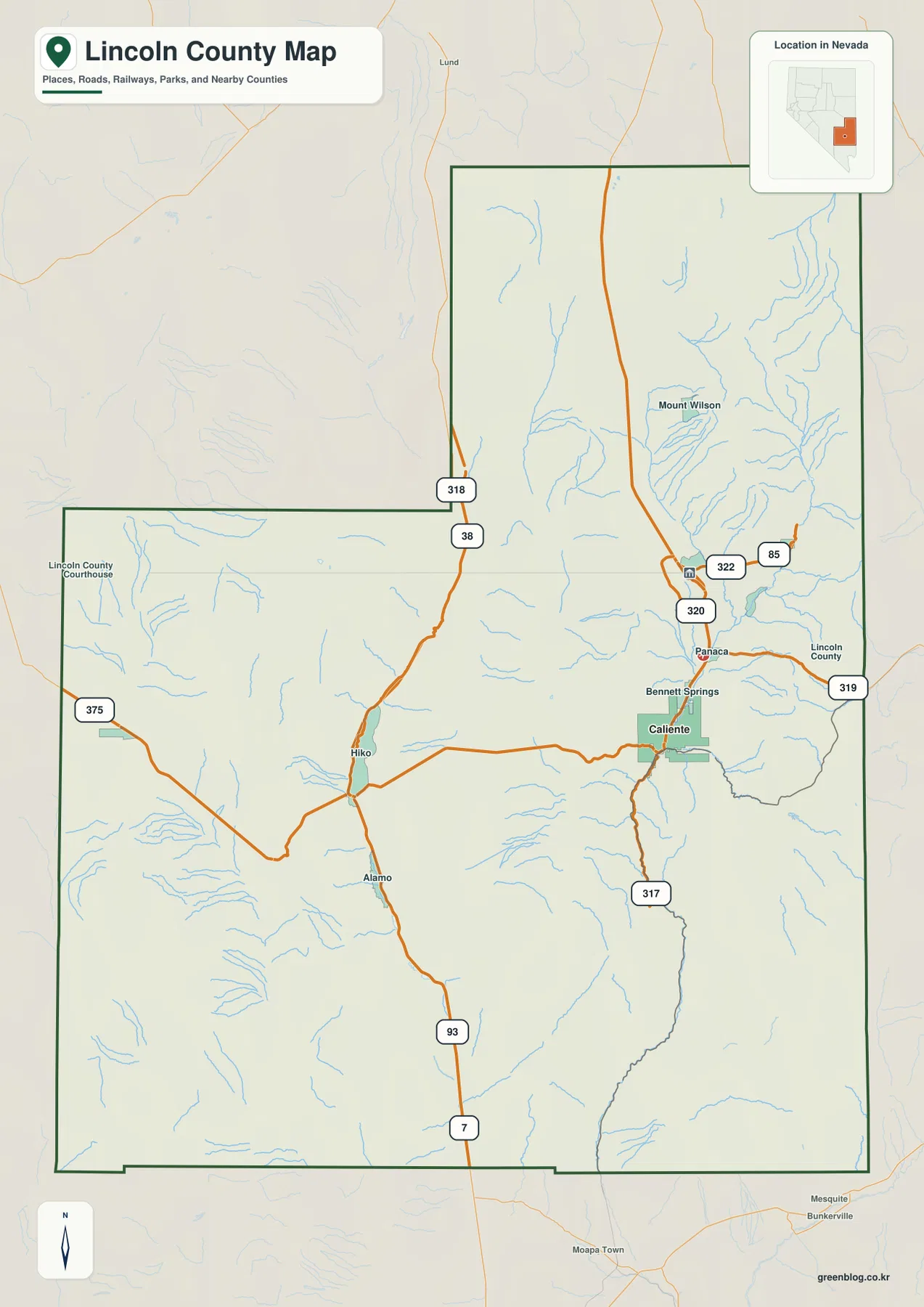
Nevada law records that Lincoln County was created in 1866 and identifies Pioche as the county seat. The county was once larger; in 1909 its southern portion was detached to form Clark County. On the supplied map, the Lincoln County Courthouse label provides a useful reference for the Pioche area even though the largest ranked city on the separate city panel is Caliente.
This map is intended for regional orientation rather than live navigation. Winter weather, road work, and unpaved access can change, especially away from the main highways. Its value is showing how Caliente, Panaca, Pioche, Hiko, and Alamo relate to U.S. 93 and how the numbered state routes enter separate valleys.
Caliente is the sole ranked major city on the city panel
The city-distribution graphic contains one ranked major city: Caliente. Panaca, Pioche, Alamo, Hiko, and other named places appear on the broader county map but are not additional ranked city points on this panel. That simple display reflects a county where population and services are divided among small communities rather than concentrated in several large municipalities.
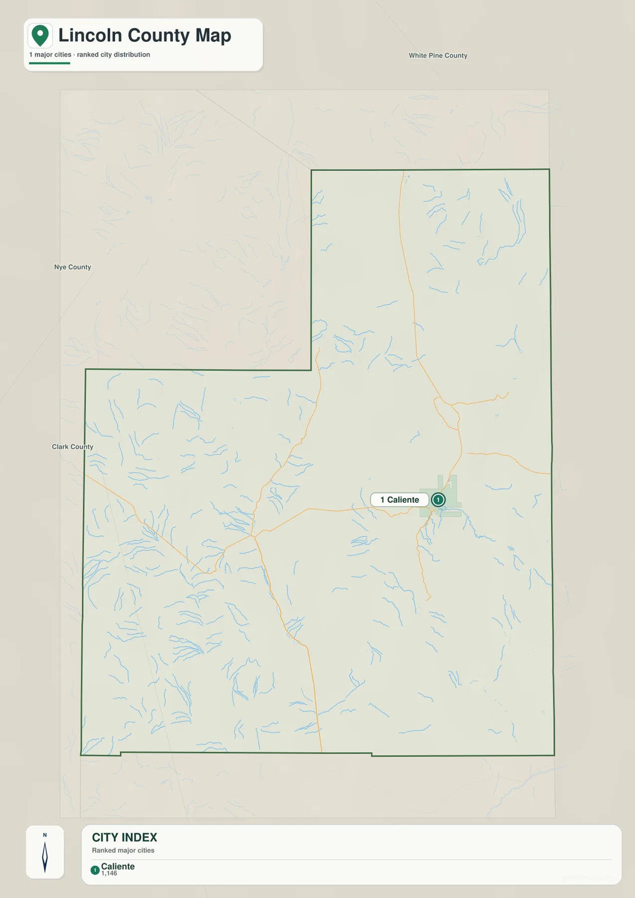
Because the city panel has no distance connectors, it should not be used to invent mileage from Caliente to Pioche, Panaca, Alamo, or Hiko. Actual road distance depends on U.S. 93 and the local state-route network. The graphic is better used to show where the county’s largest city is located and how much of the surrounding jurisdiction remains rural.
Caliente occupies the Meadow Valley corridor, while Panaca and Pioche form a nearby northern group of communities. Alamo and Hiko are separated farther south in the Pahranagat Valley. Comparing the city panel with the general map makes the county’s settlement pattern clearer: small communities sit in individual valleys with long mountain-and-desert stretches between them.
Pahranagat Lakes, Meadow Valley Wash, and Echo Canyon Reservoir
Upper Pahranagat Lake and Lower Pahranagat Lake are the most recognizable water features in the southern county. They occupy low terrain around Alamo and Hiko in the Pahranagat Valley. The U.S. Fish and Wildlife Service explains that large thermal springs north of Alamo feed the refuge’s lakes and wetlands, creating unusually valuable aquatic habitat in the dry landscape of southern Nevada.
Farther north and east, Meadow Valley Wash follows the Caliente corridor, while Clover Creek and Sam Camp Wash descend through separate mountain valleys. Kane Springs Wash is another prominent drainage in the south-central interior. These channels help explain why roads and settlements tend to follow the same lower corridors instead of crossing the ranges directly.
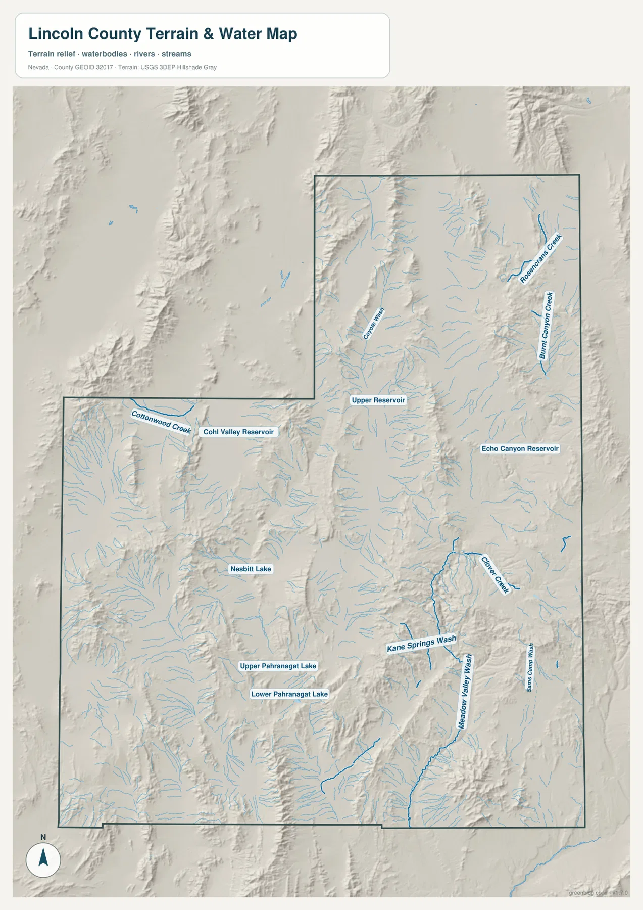
Echo Canyon Reservoir appears east of the Panaca-Pioche area, and Upper Reservoir is labeled farther north. Cottonwood Creek and additional reservoir water occur on the western side, while many short mountain streams descend through the north and northeast. The county therefore has no single river dominating the entire map; individual basins contain their own creeks, washes, lakes, and reservoirs.
Blue line width and water color are symbolic rather than measurements of flow, depth, flood hazard, or reservoir level. Conditions at Pahranagat Lakes and Echo Canyon Reservoir can vary with season and management. Use current USGS and managing-agency information for boating, fishing, flood, water-quality, and access decisions.
Relief rises from about 535 meters to more than 3,200 meters
The elevation map makes it clear that Lincoln County is not a flat desert. The displayed surface ranges from about 535 to 3,228 meters, with a mean near 1,600 meters. The southern valleys and Pahranagat side appear in green at relatively low elevation, while higher yellow-brown and dark-brown mountain country becomes more common toward the north and northeast.
Long ridges also cut through the central county and divide one basin from the next. U.S. 93 and Nevada 318 often occupy lower corridors between those ranges, and the Meadow Valley Wash corridor south of Caliente appears as a lower green band surrounded by rougher relief. The Pioche side and the Mount Wilson area in the northeast sit amid much higher terrain.
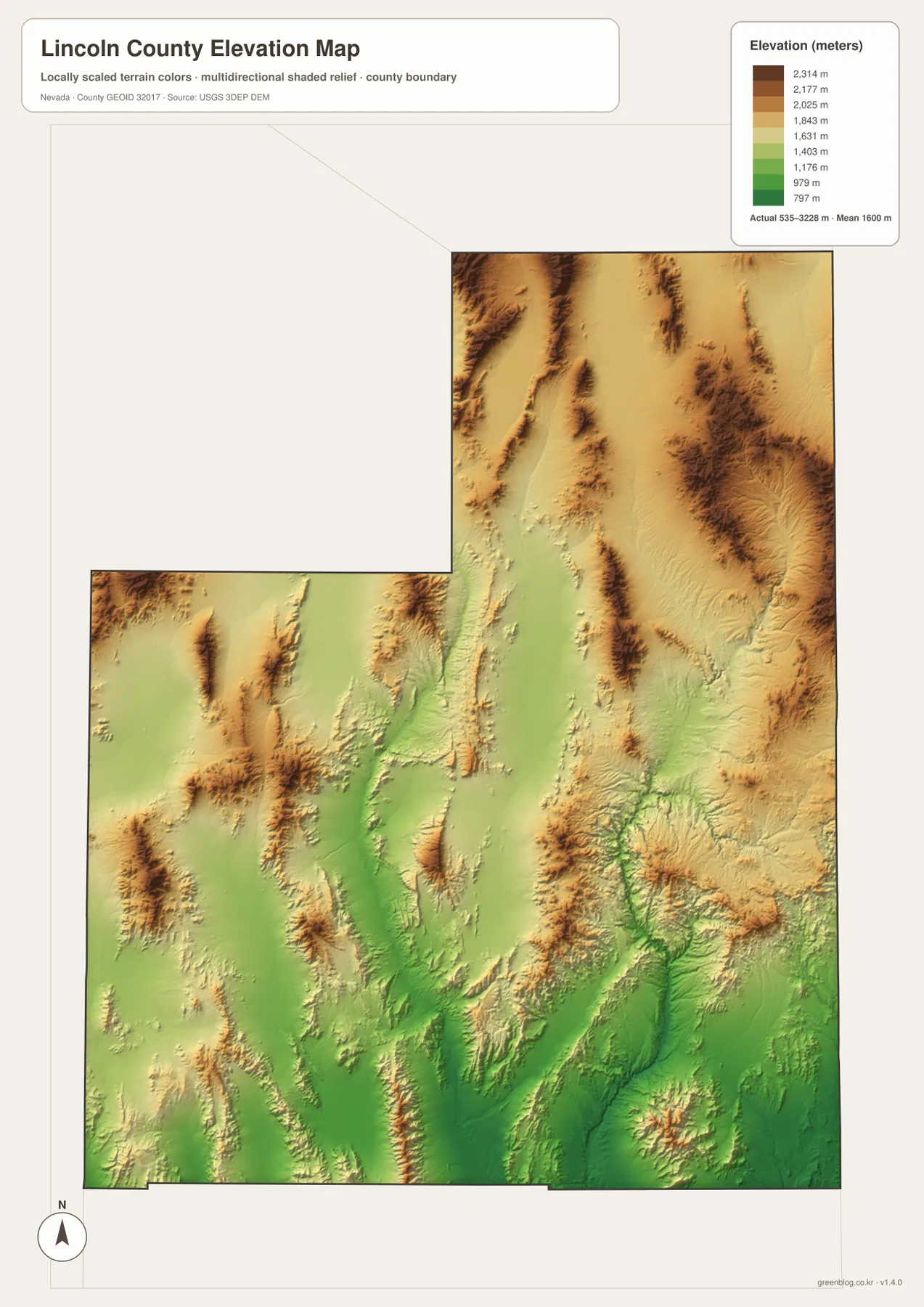
The west is also broken by parallel ranges rather than one open plain. Nevada 375 crosses broad basins separated by narrow mountain blocks, and relief increases in several areas toward the north. This repeating mountain-valley geometry is a classic part of Nevada’s Basin and Range landscape and helps explain the long, indirect routes followed by roads and streams.
This generalized elevation surface is for county-scale comparison, not surveying or engineering. Exact parcel elevation, mountain-road grade, construction benchmarks, and safety decisions require appropriate USGS source data, current field information, or professional surveying.
Cathedral Gorge and Pahranagat wetlands show very different sides of the county
Near Panaca, Cathedral Gorge State Park offers one of Lincoln County’s most distinctive landscapes. Nevada State Parks explains that erosion cut narrow canyons, spires, and cave-like formations into soft clay, silt, and volcanic-ash deposits. The park lies along the U.S. 93 corridor, making it easy to place relative to Panaca, Pioche, and Caliente on the general map.
The Pahranagat Valley farther south looks very different. Upper and Lower Pahranagat Lakes, springs, marshes, and surrounding wetland habitat form a concentrated water landscape in an otherwise dry region. The U.S. Fish and Wildlife Service manages this refuge for a wide range of birds and other wildlife, and the water map makes the unusual concentration of lakes and wetlands immediately visible.
Taken together, these two areas show why Lincoln County cannot be summarized as empty desert. Clay canyons, high ranges, wetland lakes, reservoirs, and long mountain basins all occur within the same jurisdiction. Visitors should check current park and refuge information for access, hours, and conditions; the maps here are intended for regional context rather than trail or facility navigation.
A practical order for comparing roads, water, and mountain basins
Begin with the general map by finding U.S. 93 and the Caliente-Panaca-Pioche cluster, then trace the highway south through Hiko and Alamo. Nevada 318, 375, 319, and 317 provide useful references for the western, northern, eastern, and Meadow Valley sides of the county. The city panel then reduces the settlement picture to a single ranked major city, Caliente.
For physical geography, locate Upper and Lower Pahranagat Lakes first, then follow Meadow Valley Wash toward Caliente and compare Echo Canyon Reservoir farther east. The elevation view completes the picture by showing how each of those water and road corridors occupies lower terrain between long mountain ranges.
The high-resolution JPG files are more convenient for printing and for zooming into smaller road, stream, lake, and reservoir labels than the on-page WebP previews. They remain reference maps rather than legal boundary, parcel, flood, navigation, or engineering products. For technical use, compare them with current Census, USGS, Nevada State Parks, and U.S. Fish and Wildlife Service data.
Frequently Asked Questions
Does the city map show a distance from Caliente to Pioche or Panaca?
No. Caliente is the only ranked major city on the supplied city panel, and there are no connector lines or mileage values. Actual driving distance to Pioche, Panaca, Alamo, or Hiko should be checked with current road routing.
Where are Upper and Lower Pahranagat Lakes?
Both lakes are in the southern Pahranagat Valley around Alamo and Hiko. They are part of the Pahranagat National Wildlife Refuge system, where springs and managed water support lakes, marshes, and wetland habitat.
Can the 535–3,228 meter elevation range be used for surveying?
No. Those values describe a generalized county-scale elevation surface. Exact site elevations, road grades, construction benchmarks, and engineering work require appropriate USGS source data or professional surveying.
Map File Information
Download the four high-resolution JPG maps shown on this page for Lincoln County in one ZIP archive.
- Included Files: Use only the versions confirmed in the article and supplied images
- File Type: Use the confirmed download contents
- Intended Use: Printing, education, presentations, and map-based projects
Related Maps
Sources and references
County creation and the Pioche county seat are supported by Nevada Legislature records. Cathedral Gorge information comes from Nevada State Parks, and Pahranagat Lakes and wetlands from the U.S. Fish and Wildlife Service. The federal sources below provide authoritative boundary, hydrography, and elevation references.
- Nevada Legislature – Lincoln County Creation and County Seat
- Nevada State Parks – Cathedral Gorge State Park
- U.S. Fish and Wildlife Service – Pahranagat National Wildlife Refuge
- U.S. Census Bureau – TIGER/Line Shapefiles
- USGS – National Hydrography
- USGS – 3D Elevation Program
Green Map creates custom-edited map images using open geographic data sources such as geoBoundaries, Natural Earth, OpenStreetMap, and government open data. These maps are edited visual materials, not raw data files, and are provided for education, documents, presentations, and graphic reference.