Loup County occupies a sparsely settled part of north-central Nebraska where Taylor is the clear community and government center inside a broad Sandhills landscape. U.S. 183 meets Nebraska Highway 91 at Taylor, the North Loup River crosses the southern part of the county, and the Calamus River cuts southeast through the northern Sandhills toward Calamus Reservoir. In a county with few town labels, rivers, valleys, and rolling dune-like ridges are often more useful orientation features than settlements. This page connects Taylor and the roads with the two river systems, reservoir country, and an elevation range of about 667 to 830 meters. The four original high-resolution JPG maps can also be downloaded together in one ZIP file for printing or detailed viewing. High-resolution map files are available for download in the section below.
Loup County’s official website identifies Taylor as the county seat and lists it as the county’s only town in its 2020 community summary, with Almeria noted as unincorporated. Taylor’s local tourism site places the community at the junction of U.S. 183 and Highway 91 and highlights both the North Loup and Calamus rivers as major parts of the local landscape. The maps reflect that pattern: settlement is concentrated in the south, while most of the county is defined by Sandhills relief, streams, and widely spaced rural roads.
Table of Contents
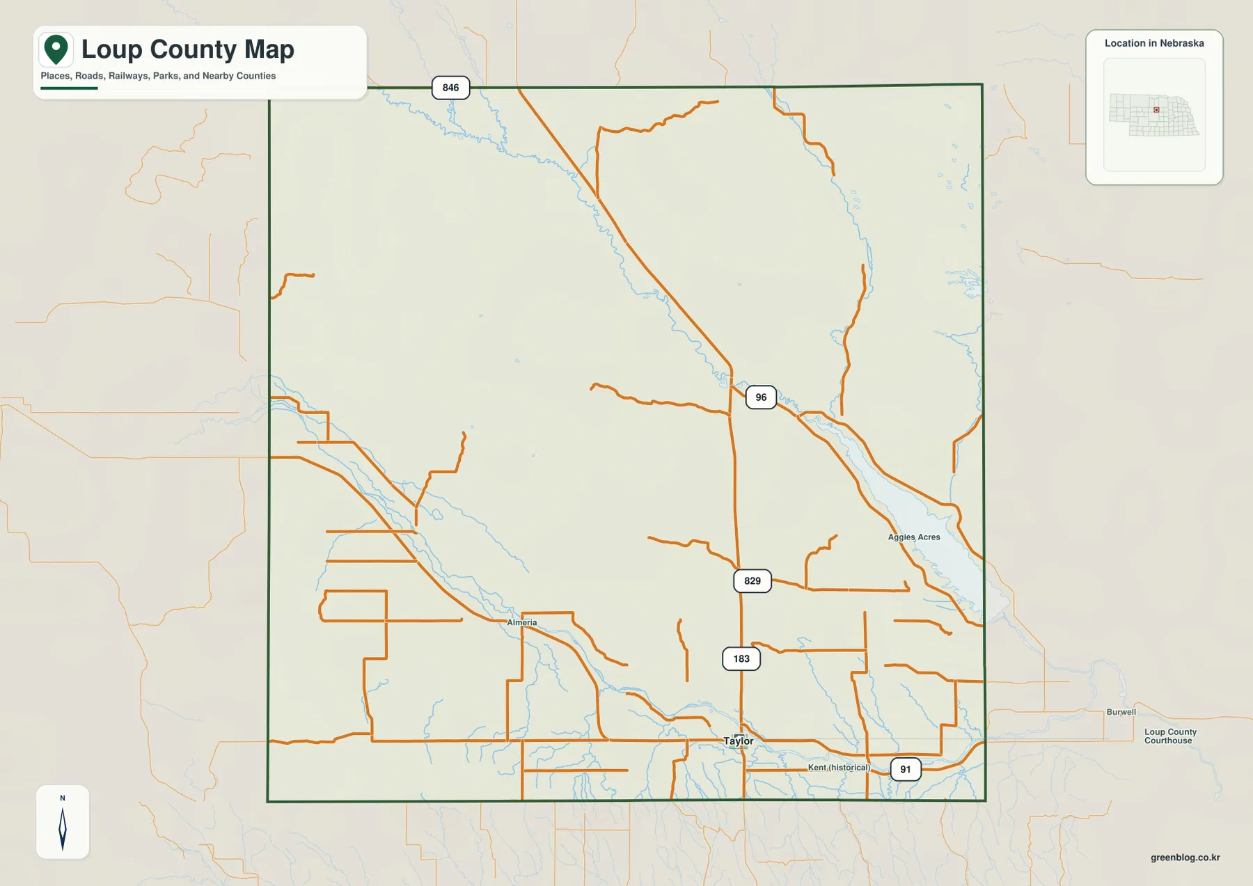
Taylor’s U.S. 183 and Highway 91 junction is the simplest road reference
Taylor is the first place to locate on the general county map. U.S. 183 runs south through the community, while Highway 91 approaches from the Almeria side in the west and continues east toward Burwell. Taylor’s visitor information center is located at the junction of the two highways, reinforcing how useful that intersection is for understanding the county’s southern road network.
Almeria appears west of Taylor, and the historical Kent location is labeled to the east. Neither functions as a second major town today. North of the Taylor corridor, settlement labels become scarce and numbered rural roads, creeks, and river valleys take over as geographic references. Burwell appears outside the county to the east and provides a useful landmark for the Calamus Reservoir and Garfield County direction.
The surrounding counties help place Loup County within central Nebraska. Blaine and Custer counties are to the west and southwest, Rock and Brown counties lie to the north, Garfield and Valley are on the eastern side, and Holt appears toward the southwest edge of the broader map. Because Loup County has so few large settlements, those neighboring names are particularly useful for regional orientation. Current closures and driving conditions still require a live transportation source rather than this static map.
A one-city distribution map captures how lightly settled the county is
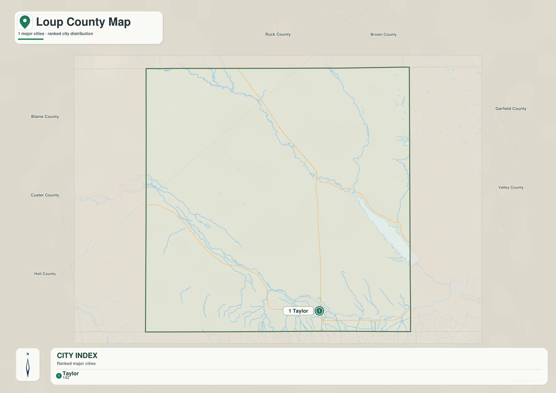
The city-distribution map is unusually simple because Taylor is the only ranked major city shown. Instead of comparing several communities, the graphic emphasizes a single settlement near the southern side of a large rural county. That is an important geographic fact in its own right: most of Loup County is not organized around a chain of towns.
The supplied graphic prints an index value of 142 beside Taylor, but that number should not be treated as a current official population count. Loup County’s official 2020 summary lists Taylor at 228 people, indicating that the map index uses a different reference point or date. The city sheet is therefore best used to understand settlement concentration rather than as a current demographic table.
Taylor also lies close to the North Loup River valley and the county’s main highway junction. The northern half of Loup County is much larger in area but has no comparable city marker on the ranked map. Ranch country, Sandhills, and river valleys dominate there, while government services and community activity remain concentrated around Taylor.
The North Loup River creates the main southern valley near Taylor
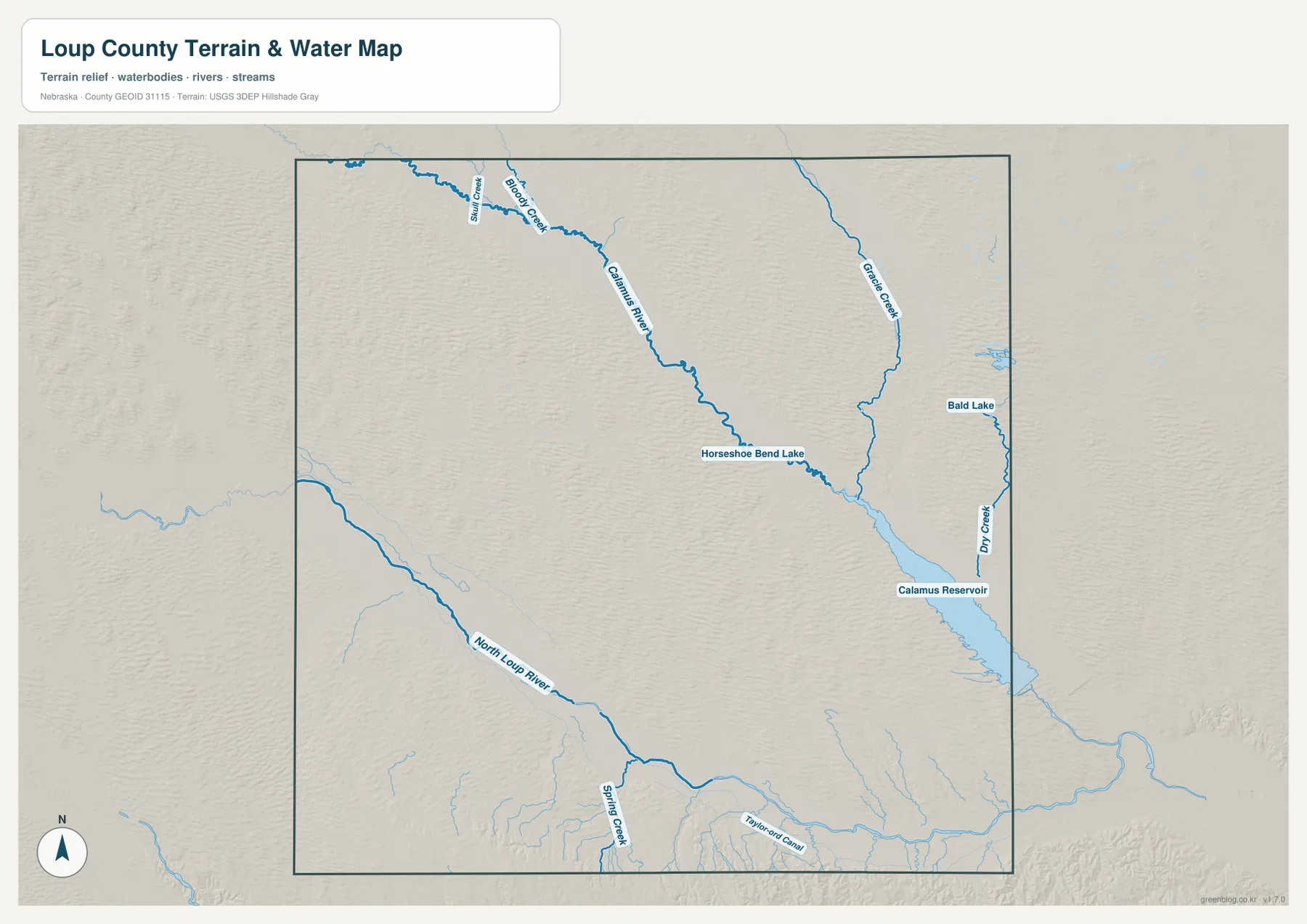
The North Loup River is the dominant water feature across the southern portion of the county. It enters from the southwest, follows a broad valley toward the southeast, and passes near the Taylor side of the county before continuing toward Valley County. Taylor’s location near this river corridor and the junction of U.S. 183 and Highway 91 makes the southern valley the most concentrated part of Loup County in both settlement and transportation.
Smaller tributaries descend from the surrounding Sandhills into the river. Spring Creek is labeled in the southern interior, and Taylorwood Canal appears farther east near Taylor. Numerous unnamed short channels cut the hills along the North Loup valley. On the elevation surface, the river forms a long green lowland that is easy to distinguish from the higher rolling ground around it.
The North Loup and Calamus rivers do not share the same immediate valley, but together they provide the best natural framework for the county. Taylor’s recreation site highlights both rivers as major local features. In a place where towns are widely spaced, following the river corridors often gives a clearer mental map than relying on roads alone.
The Calamus River cuts across northern Sandhills toward reservoir country
The Calamus River is the defining water feature in northern Loup County. It runs southeast through the Sandhills, receiving tributaries such as Skull Creek and Bloody Creek along the way. Horseshoe Bend Lake lies close to the river in the central-northern portion of the map. The long green valley contrasts strongly with the tightly rippled Sandhills ridges surrounding it.
Gracie Creek descends through the northeast, while Dry Creek and Bald Lake appear near the eastern edge. The Calamus River then reaches the Calamus Reservoir area along the Loup–Garfield side of the map. Nebraska Game and Parks describes Calamus State Recreation Area as a major Sandhills reservoir destination with a lake of roughly 5,123 acres and a section of the Calamus River included in the recreation area.
The water sheet is a general geographic reference rather than a flood, property, access, or real-time lake-status map. Calamus Reservoir is an irrigation reservoir and water levels can fluctuate, so shorelines, ramps, and boating access may differ from the static image. Current conditions should be checked with Nebraska Game and Parks before a visit.
A 667–830 meter range separates higher southwest Sandhills from the river valleys
The supplied elevation map gives an actual Loup County range of about 667 to 830 meters, with a mean near 736 meters. The highest brown and orange terrain is concentrated in the southwest and parts of the west, while the North Loup and Calamus river valleys appear as long green lowlands. The roughly 163-meter difference between the mapped high and low points is enough to reveal the county’s rolling Sandhills relief very clearly.
The Calamus valley forms a diagonal low corridor from the northwest toward the east. On both sides, dense parallel Sandhills ridges create a rippled surface, and tributaries form short green branches that feed into the main river. Elevations become lower and greener toward the reservoir side of the eastern county.
The southwest stands higher overall, but the North Loup River cuts a broad low valley through that high country. Taylor’s southern setting is also lower than much of the surrounding Sandhills because of the river and tributary network. Loup County is therefore not simply a flat grassland; it contains two major low river corridors separated by extensive rolling uplands.
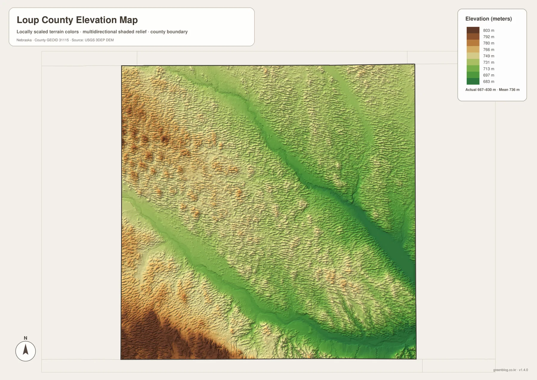
The elevation surface is generalized for county-scale comparison. It is not survey-grade information for a ranch parcel, building site, drainage plan, road grade, or engineering project. Those tasks require current detailed elevation data such as the USGS 3D Elevation Program and, when necessary, professional field measurements. For regional study, the map clearly shows the relationship between Sandhills uplands and river valleys.
Taylor, Almeria, and Kent preserve traces of a much smaller settlement network
Loup County was organized in 1883, and Taylor became the county seat that same year. Historical material from the Nebraska Association of County Officials notes that Taylor competed with Kent and Almeria for the seat and defeated Almeria by only two votes. Today the general county map still labels Taylor prominently while Almeria and the historical Kent location remain much smaller references.
The modern city-distribution map shows how much the settlement pattern has narrowed. Taylor is the only ranked major community, and Loup County’s official website describes Almeria as unincorporated. Taylor remains small, but the courthouse, public school, community events, and local services concentrate its importance far beyond what its population alone might suggest.
Taylor’s position near the southern edge is also worth noting. It is not centered geometrically within the county; instead, it lies close to the North Loup River valley and the crossing of Highway 91 and U.S. 183. Northern Loup County has the Calamus River but almost no comparable settlement concentration, so geography and transportation have pulled community life toward the south.
In the Sandhills, rivers and valleys are often more useful than town names
Loup County sits within the Nebraska Sandhills, and the elevation surface shows hundreds of narrow dune-like ridges repeating across the landscape. The North Loup and Calamus rivers interrupt that texture with much broader, lower valleys. Away from Taylor, the scarcity of city labels makes those river corridors the most practical way to divide the county into recognizable areas.
Following the Calamus River northward and westward reveals Horseshoe Bend Lake, Skull Creek, Bloody Creek, and other tributary valleys. Moving back to the south, the North Loup River provides a separate reference for Taylor, Almeria, and the southern county roads. These features give structure to an area that can otherwise look almost empty on a settlement map.
The four map views reinforce the same county-specific pattern without needing a generic map inventory. Roads and settlement cluster around Taylor, named water features organize the north and south into two major river corridors, and the elevation surface shows those corridors as lower green terrain between higher Sandhills ridges.
Choose the view according to whether you need Taylor, water features, or Sandhills relief
The general county sheet is the most useful starting point for Taylor, U.S. 183, Highway 91, Almeria, and neighboring county directions. The city-distribution graphic is intentionally much simpler and is best when the question is how strongly settlement is concentrated in Taylor.
The terrain-and-water sheet adds the North Loup River, Calamus River, Horseshoe Bend Lake, Gracie Creek, and the Calamus Reservoir area. The elevation map shifts attention to height, making the higher southwest and the two lower river corridors easier to compare. Using the water and elevation versions together is especially helpful in a Sandhills county where many ridges look similar on a road map.
For classroom work or regional comparison, a practical sequence is to locate Taylor and the highways first, follow the two major rivers next, and then compare their valleys with the elevation surface. The WebP images on the page are convenient previews, while the original JPG files are better for enlarging small stream labels or printing. Legal boundaries, flood decisions, current water levels, road conditions, surveying, and engineering work should rely on the latest authoritative source for the specific task.
Frequently Asked Questions
Where is the Loup County seat?
Taylor is the county seat. Loup County’s official website lists the courthouse in Taylor, and the local tourism site places the community at the junction of U.S. 183 and Highway 91. It is also the only ranked major city shown on the supplied city-distribution map.
Is Calamus Reservoir inside Loup County?
The reservoir appears along the eastern Loup County–Garfield County side of the supplied map, where the Calamus River flows toward the lake. The recreation area and much of the reservoir are associated with the Burwell side, so visitors should use Nebraska Game and Parks information for current access and facilities rather than relying on the county map alone.
Can the 667–830 meter elevation range be used for surveying or construction?
No. The range is a generalized county-scale summary intended to compare Sandhills uplands with the lower North Loup and Calamus river valleys. Parcel surveys, construction, drainage design, and road engineering require current detailed elevation data and professional measurements.
Map File Information
The county, city-distribution, terrain-and-water, and elevation maps are available together in one ZIP file. It contains four original high-resolution JPG maps suitable for detailed viewing and printing.
- Included Files: County map, city-distribution map, terrain-and-water map, elevation map
- File Type: JPG files in a ZIP archive
Related Maps
Sources and references
These official and public sources provide additional context for Loup County government, Taylor, Calamus Reservoir, administrative boundaries, waterways, and elevation.
- Loup County, Nebraska – About Us – county seat, area, Taylor, and Almeria information
- Taylor, Nebraska – Recreation – U.S. 183 / Highway 91 junction and North Loup / Calamus River context
- Nebraska Game and Parks – Calamus Reservoir – reservoir and State Recreation Area information
- U.S. Census Bureau TIGER/Line – administrative boundary data
- USGS National Hydrography – river and stream data
- USGS 3D Elevation Program – elevation data
Green Map creates custom-edited map images using open geographic data sources such as geoBoundaries, Natural Earth, OpenStreetMap, and government open data. These maps are edited visual materials, not raw data files, and are provided for education, documents, presentations, and graphic reference.