Madison County in northeastern Nebraska combines a large regional center at Norfolk with a separate county seat at Madison. U.S. 81 runs through both communities, while U.S. 275 reaches Norfolk from the west through the Battle Creek and Meadow Grove side of the county. The Elkhorn River and North Fork Elkhorn River shape the low northeastern landscape, while higher creek-cut hills spread across the west and southwest toward Tilden and Newman Grove. This page follows those settlement, road, water, and elevation patterns, and the four original high-resolution JPG maps are available together in a ZIP file for printing or close viewing. High-resolution map files are available for download in the section below.
The county’s official website identifies Norfolk as its largest community and Madison as the county seat, and it specifically notes that the Elkhorn River flows through Madison County. The maps show why those distinctions matter. Norfolk occupies broad low ground in the Elkhorn valley, while Madison lies farther south among smaller tributaries. Elevation ranges from about 455 to 599 meters, with the lowest terrain concentrated in the northeast and higher rolling country becoming more prominent toward the west and southwest.
Table of Contents
Norfolk and Madison serve different county roles
Norfolk is the dominant city on the general county map. U.S. 81 runs north–south through the city, U.S. 275 approaches from the Battle Creek and Meadow Grove direction, and Nebraska Highway 24 provides another eastern connection. The City of Norfolk describes the community as a regional economic center in the Elkhorn River Valley and confirms that U.S. Highways 81 and 275 intersect there.
Madison is much smaller but remains the county seat and the location of the Madison County Courthouse. U.S. 81 connects it directly with Norfolk to the north. County history adds an important distinction: Norfolk was initially selected as the county seat, but a later vote moved the seat to Madison. The largest city and the administrative center therefore should not be treated as the same place.
The land between the two cities is largely rural and crossed by many small drainage channels. Norfolk sits within a broad Elkhorn and North Fork lowland, while the Madison side is more closely associated with Union Creek and tributary valleys. That contrast becomes much clearer when the road map is compared with the terrain and elevation views.
Six ranked communities spread from the Elkhorn Valley to the western farm country
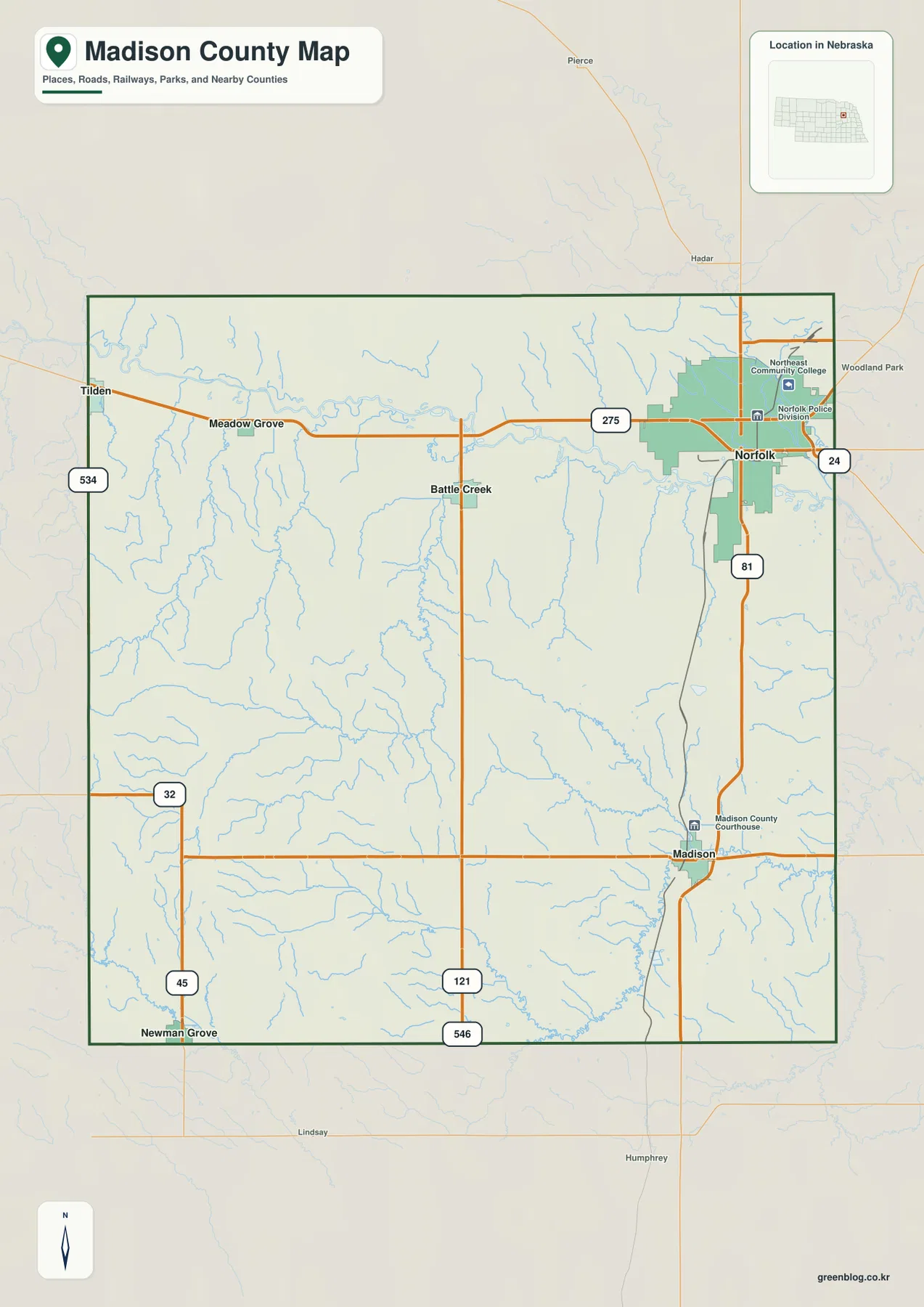
The city-distribution map ranks Norfolk first, followed by Madison, Battle Creek, Tilden, Newman Grove, and Meadow Grove. Its printed index values are 26,054 for Norfolk, 2,079 for Madison, 1,456 for Battle Creek, 936 for Tilden, 885 for Newman Grove, and 174 for Meadow Grove. These values belong to the supplied graphic and are best treated as reference figures rather than a current official population table.
The spatial pattern is more informative than the ranking alone. Norfolk occupies the northeast, Madison is in the southeastern half of the county, and Battle Creek sits nearer the center-north along the U.S. 275 corridor. Meadow Grove lies farther west, Tilden reaches the northwestern edge, and Newman Grove anchors the southwest near the Platte and Boone County directions.
This distribution prevents Madison County from being reduced to the Norfolk urban area. Battle Creek and Meadow Grove are useful references for the Elkhorn and its tributaries, while Newman Grove marks the higher southwestern terrain near Shell Creek. The city map removes most road detail, making the broad settlement pattern easier to compare.
The Elkhorn and North Fork create the broad lowland around Norfolk
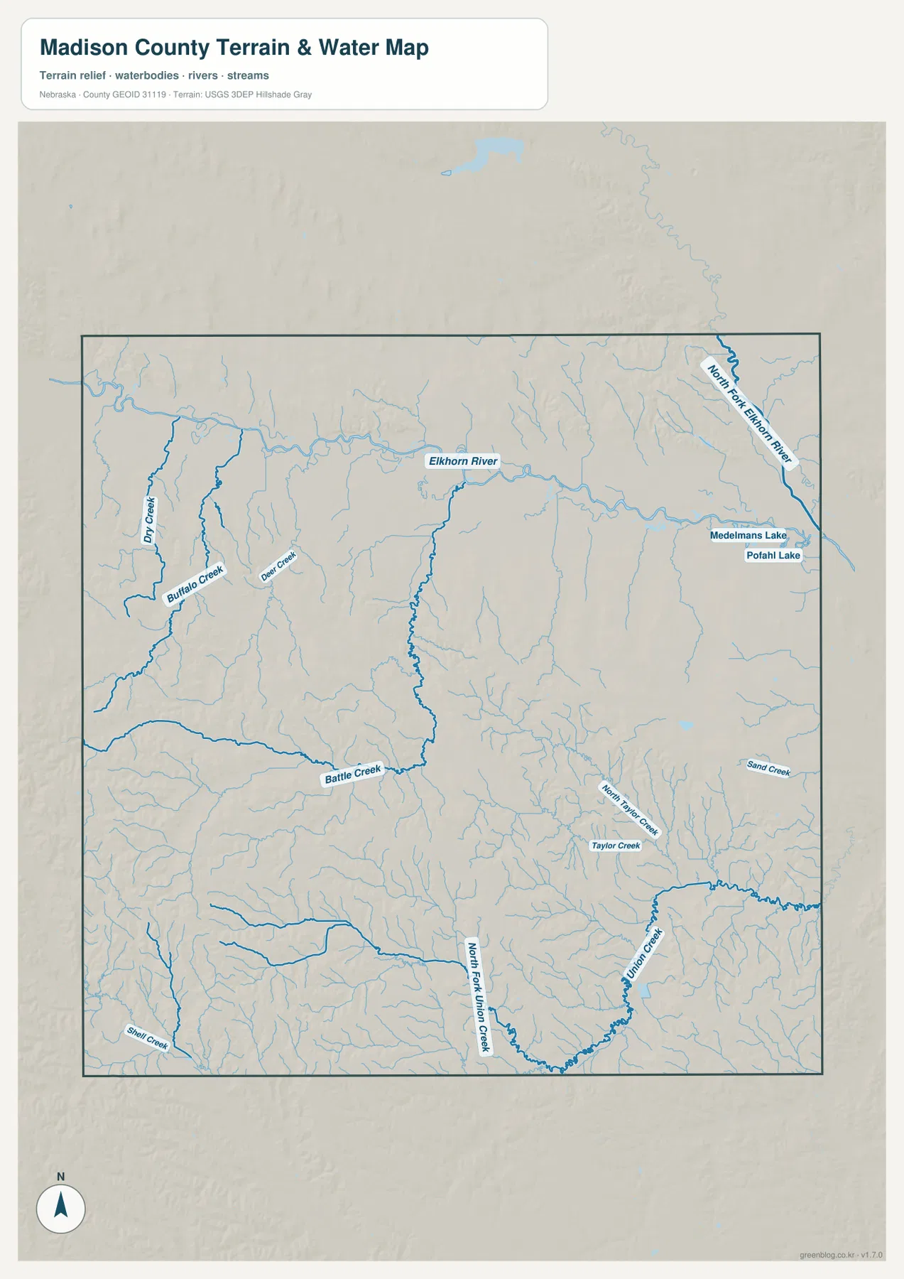
The Elkhorn River is the strongest continuous water reference across the county. It enters from the west, passes north of Meadow Grove and Battle Creek, and continues toward Norfolk. The City of Norfolk describes the community as lying in the Elkhorn River Valley, which matches the broad low terrain shown around the river on both the water and elevation maps.
The North Fork Elkhorn River approaches Norfolk from the northeast. Norfolk’s official history traces the city’s founding to settlers who arrived in 1866 at the junction of the Elkhorn and North Fork valleys. That local history makes the map especially easy to interpret: Norfolk grew where two important lowland corridors come together.
Farther west, Buffalo Creek and Dry Creek divide the rural land around Tilden and Meadow Grove, with Deer Creek providing another smaller tributary reference. Nebraska Game and Parks includes the Elkhorn River as a fishing stream crossing Madison County, confirming its broader importance beyond the county map itself.
Battle Creek and Union Creek carve a denser network through the central and southern hills
South of the main Elkhorn corridor, the drainage becomes more tightly branched. Battle Creek enters from the west and passes near the community of the same name before continuing east. Its tributaries cut through rolling agricultural terrain, making the creek a useful geographic reference for the center of the county.
Near Madison, Union Creek bends through the southeastern interior and is joined by North Fork Union Creek. Taylor Creek and North Taylor Creek add more narrow valleys nearby. In the southwest, Shell Creek appears near Newman Grove, creating another distinct low corridor through some of the county’s higher terrain.
Medelmans Lake and Pofahl Lake are labeled east of Norfolk as small water bodies. They are not comparable in scale with the Elkhorn system, but they provide useful local references around the northeastern urban area. The terrain-and-water map is intended for geographic comparison, not for flood determinations, parcel boundaries, live water levels, or navigation decisions.
Elevation falls from western uplands toward the Norfolk and Elkhorn lowlands
The supplied elevation map gives an actual county-wide range of about 455 to 599 meters, with a mean near 518 meters. The highest brown and orange terrain is concentrated in the west and southwest, while the Norfolk and Elkhorn River area in the northeast appears in lower green shades. The roughly 144-meter difference between the mapped high and low points produces a clear regional contrast without requiring mountain-scale relief.
Around Tilden in the northwest, higher ridges are cut by Dry Creek and Buffalo Creek valleys. Moving east toward Meadow Grove and Battle Creek, the broad Elkhorn lowland becomes increasingly obvious. The southwest around Newman Grove contains some of the county’s most extensive high terrain, but Shell Creek and smaller tributaries cut narrow lower channels through it.
The eastern side is generally lower. Norfolk and the North Fork Elkhorn corridor occupy some of the lowest terrain, while Madison is lower than the western uplands but still crossed by a complicated network of local valleys. The county therefore trends downward from the west toward the northeast while remaining strongly dissected by streams in the central and southern interior.
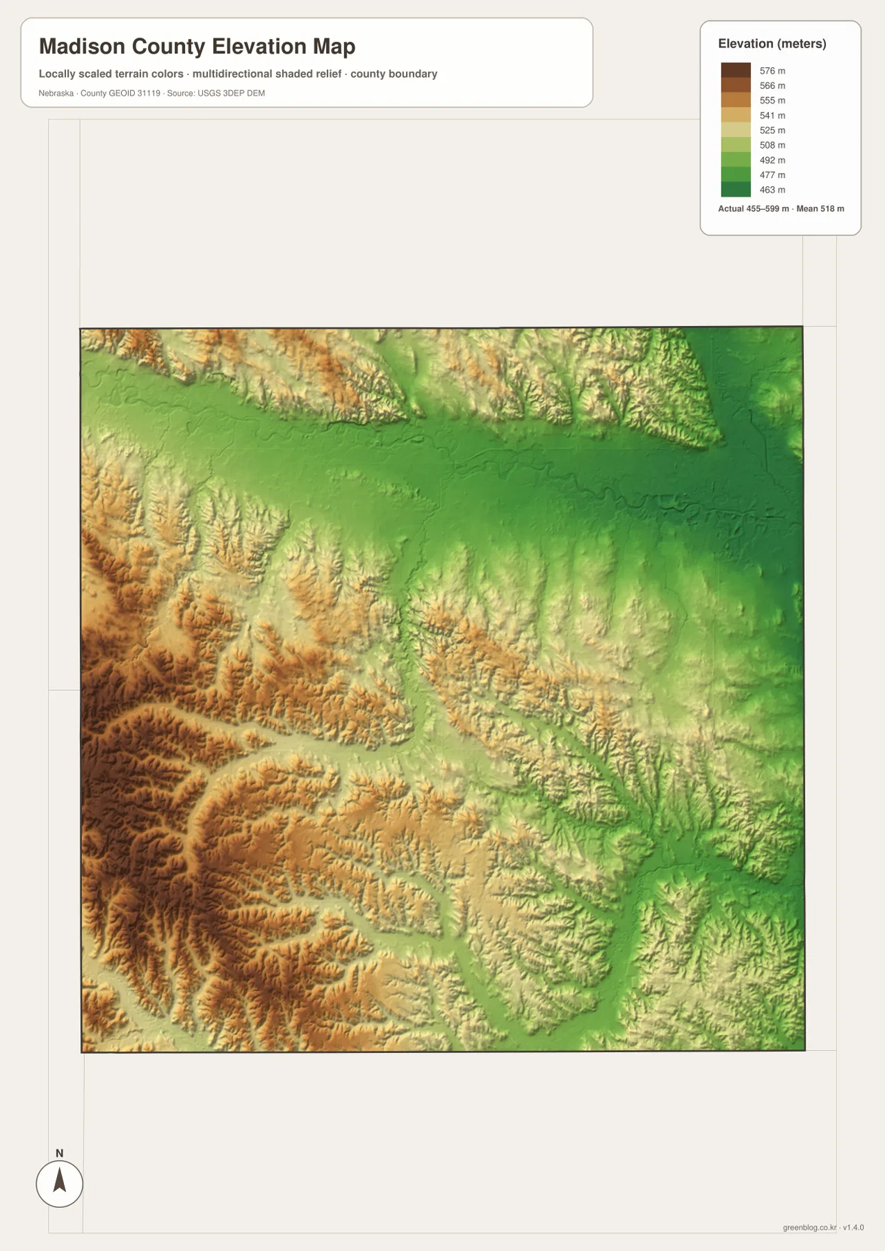
This elevation surface is generalized for county-scale comparison. It is not survey-grade information for a parcel, building site, drainage design, road grade, or engineering project. Those tasks require current detailed elevation data such as the USGS 3D Elevation Program and, where appropriate, professional field measurements.
Norfolk’s growth and Madison’s county-seat role create a two-center county
Madison County’s official history says the county was organized in 1867 and that Norfolk was first selected as the county seat. A later dispute and vote moved the seat to Madison. Today the courthouse remains in Madison, while Norfolk has become the much larger commercial, educational, and transportation center.
Norfolk’s location helps explain that growth. The city’s official history places its earliest settlement at the meeting of the Elkhorn and North Fork valleys, and modern U.S. 81 and 275 continue to reinforce its regional accessibility. The combination of valley terrain and transportation has made Norfolk the county’s dominant urban center even though it is not the seat of government.
Madison remains important for a different reason. It connects the county government with the southern rural interior along U.S. 81, while Battle Creek, Meadow Grove, Tilden, and Newman Grove provide smaller centers across the west. The county makes more sense when these roles are considered together rather than assuming that every function is concentrated in Norfolk.
Use settlement, water, and relief together to understand the county
The general county map is the best starting point for Norfolk, Madison, Battle Creek, Tilden, Newman Grove, U.S. 81, and U.S. 275. The city-distribution map removes much of that road detail and emphasizes the relative scale and location of the six ranked communities.
For physical geography, the terrain-and-water map adds the Elkhorn River, North Fork Elkhorn River, Battle Creek, Union Creek, Buffalo Creek, and other tributaries. The elevation map shifts attention to height, making the higher western hills and lower northeastern valley especially clear. Comparing the water and elevation sheets shows how the creek network follows the low corridors between ridges.
A practical study sequence is to locate Norfolk and Madison first, trace the Elkhorn system and southern tributaries next, and then compare the same areas on the elevation surface. The WebP images on the page are convenient previews, while the original JPG files are better for enlarging labels or printing. Legal boundaries, flood decisions, current road or water conditions, surveying, and engineering work should rely on the latest authoritative source for the specific task.
Frequently Asked Questions
Is Norfolk or Madison the Madison County seat?
Madison is the current county seat. Norfolk is the county’s largest city, but the courthouse and principal county government offices are in Madison. County history notes that Norfolk was selected first before the seat later moved to Madison by vote.
Why is the Norfolk area lower than much of western Madison County?
Norfolk lies within the Elkhorn River and North Fork Elkhorn valley system. The elevation map shows those river corridors in lower green shades, while the western and southwestern creek hills rise into higher tan and brown terrain.
Can the 455–599 meter elevation range be used for surveying or construction?
No. The range is a generalized county-scale summary. Parcel surveys, construction, drainage design, and road engineering require current detailed elevation data and professional measurements.
Map File Information
The county, city-distribution, terrain-and-water, and elevation maps are available together in one ZIP file. It contains four original high-resolution JPG maps suitable for detailed viewing and printing.
- Included Files: County map, city-distribution map, terrain-and-water map, elevation map
- File Type: JPG files in a ZIP archive
Related Maps
Sources and references
These official and public sources provide additional context for Madison County government, Norfolk history, the Elkhorn River, administrative boundaries, and elevation.
- Madison County, Nebraska – About Us – county seat, six communities, Elkhorn River, and county history
- City of Norfolk – About Norfolk – Norfolk’s location, highways, Elkhorn and North Fork valleys, and city history
- Nebraska Game and Parks – Fishing Guide – Elkhorn River reference for Madison County
- U.S. Census Bureau TIGER/Line – administrative boundary data
- USGS National Hydrography – river and stream data
- USGS 3D Elevation Program – elevation data
Green Map creates custom-edited map images using open geographic data sources such as geoBoundaries, Natural Earth, OpenStreetMap, and government open data. These maps are edited visual materials, not raw data files, and are provided for education, documents, presentations, and graphic reference.