Merrick County sits in central Nebraska along the Platte River Valley, with Central City serving as the county seat and the main road reference. U.S. 30 crosses the county from southwest to northeast, Nebraska Highway 14 runs through Central City from north to south, and Highway 92 provides another east–west connection. Palmer, Clarks, Silver Creek, and Chapman are spaced across a broad agricultural landscape, while the Platte River forms much of the southeastern boundary. Wood River, Prairie Creek, Silver Creek, and several sloughs run through the lower interior. This page connects those roads, communities, waterways, and the county’s 462–608 meter elevation range, and the four original high-resolution JPG maps can be downloaded together in one ZIP file. High-resolution map files are available for download in the section below.
Merrick County’s official history identifies Central City as the county seat and describes the Platte River as the county’s southeastern boundary. It also emphasizes the importance of the Union Pacific Railroad and U.S. Highway 30 in the growth of local communities. The maps preserve that same pattern: Central City and several towns line up near the Platte Valley corridor, while higher ground spreads across the western and southwestern side of the county before gradually descending toward the river plain.
Table of Contents
Central City ties together the county’s main road network
Central City is the easiest place to start on the general county map. U.S. 30 approaches from the Chapman side in the southwest, passes through the Central City area, and continues northeast toward Clarks and Silver Creek. Highway 14 crosses the city on a north–south alignment, while Highway 92 provides another major connection across the central interior. Those three routes create a practical framework for locating smaller rural roads without having to memorize the entire county grid.
Archer is labeled west of Central City, and Palmer lies farther northwest in the broad agricultural interior. Chapman follows the U.S. 30 corridor to the southwest. Clarks sits northeast of Central City, with Silver Creek farther along the same general Platte Valley direction near the eastern end of the county. Highway 22 is useful for orienting the far northwestern Palmer side.
The county’s outer shape also provides important context. Nance County is north, Hall and Howard counties are to the west, Platte and Polk counties are east, and Hamilton County lies south of the broader map area. Unlike the stepped northern boundary, the southeastern edge follows the Platte River corridor on a long diagonal. That river boundary is one of the county’s most recognizable geographic features.
Direct distances show how four communities spread around Central City
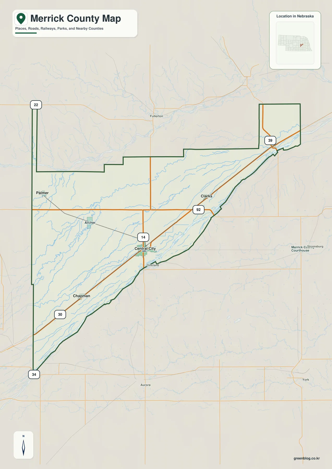
The city-connections map uses Central City as the hub and gives direct distances to four surrounding communities. Clarks and Chapman are each shown at about 11 miles, Palmer at about 16 miles, and Silver Creek at about 22 miles. These are straight-line measurements, not driving distances. Road mileage can be longer depending on U.S. 30, Highway 92, and the county-road route used.
The supplied graphic also prints reference values of 3,061 for Central City, 403 for Palmer, 341 for Silver Creek, 330 for Clarks, and 290 for Chapman. Those figures are part of the provided map and should be treated as a map index rather than a live population table. Current demographic questions are better answered with recent Census data.
The pattern makes Central City’s geographic role easy to see. Palmer represents the northwest, Chapman the southwest U.S. 30 corridor, and Clarks and Silver Creek the northeastern Platte Valley side. In a lightly urbanized county, a simple hub-and-distance view provides a useful sense of scale between communities.
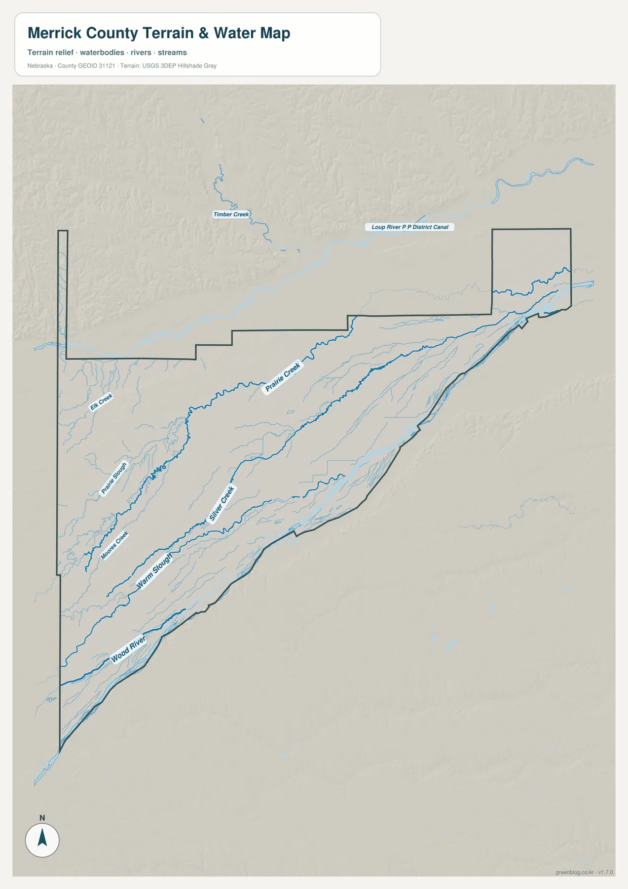
The Platte River boundary runs beside Wood River and Warm Slough
The Platte River is the county’s strongest natural boundary. Merrick County’s official profile states that the river forms the southeastern edge, and the map shows the county line following the broad Platte Valley from southwest to northeast. Central City, Chapman, Clarks, Silver Creek, and U.S. 30 all sit within or close to this same general transportation and river corridor.
Wood River and Warm Slough lie just northwest of the Platte. Wood River enters from the southwestern side and follows a long northeastern course through low agricultural terrain. Warm Slough parallels part of that route near Central City. Numerous smaller ditches and channels appear around them, reflecting the dense drainage and irrigation network of the valley.
The resulting landscape can look nearly flat, but the water map shows several separate channels rather than one single river. The Platte is the broad boundary river, while Wood River and Warm Slough occupy interior farmland. This map is intended for general geographic reference, not for flood determinations, property boundaries, current river stages, or navigation.
Prairie Creek and Silver Creek form long low corridors through the interior
Prairie Creek provides one of the clearest water references across central Merrick County. It runs from the western interior toward the northeast, with Prairie Slough following a similar direction farther south. Together they cross the open agricultural area north of Central City and west of Clarks, forming shallow lowlands rather than the deeply incised valleys found in hillier parts of Nebraska.
Silver Creek is another important named channel in the northeastern half of the county. Its name also matches the community of Silver Creek, making the area easy to remember. Nebraska’s stream-gaging listings include monitoring locations on both Silver Creek and Prairie Creek, underscoring their importance within the Central Platte drainage network.
Moon Creek and Elk Creek appear farther west, while Timber Creek and the Loup River Public Power District Canal are visible beyond the northern side of the county map. None is as large as the Platte, but together they reveal how thoroughly Merrick County’s agricultural plain is divided by parallel streams, sloughs, and managed water channels.
Elevation drops from 608-meter western ground toward the Platte Valley
The supplied elevation map gives Merrick County an actual range of about 462 to 608 meters, with a mean near 521 meters. The highest brown terrain is concentrated along the western and southwestern side, while yellow and green shades become more common toward Central City, Clarks, Silver Creek, and the eastern river plain. The roughly 146-meter difference between the mapped high and low points creates a clear west-to-east transition even without mountainous relief.
The western edge contains the strongest local rise, followed by a long, gentler descent toward the center of the county. Higher ground around the Palmer and western Chapman side gives way to lower terrain near Central City. Farther northeast, the broad Platte and creek lowlands become increasingly green on the elevation surface.
The lowest terrain is associated with the Platte and Wood River corridor, while Prairie Creek and Silver Creek occupy narrower low strips across the interior. Comparing the water and elevation maps makes the shared southwest-to-northeast drainage direction especially clear. Central City sits close to the transition between the higher western farm country and the flatter eastern valley.
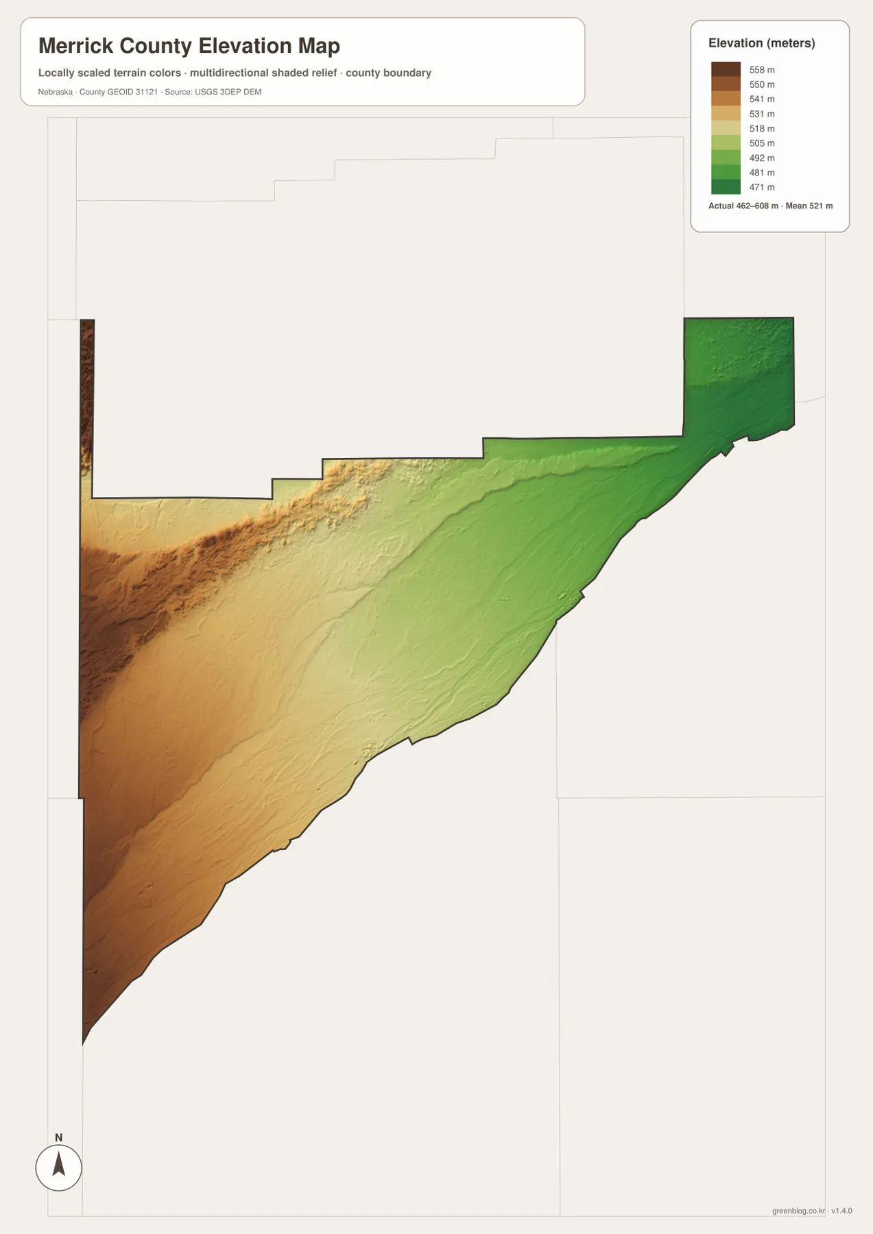
The elevation surface is generalized for county-scale comparison. It is not survey-grade information for a parcel, drainage design, building site, road grade, or engineering project. Those tasks require current detailed elevation data such as the USGS 3D Elevation Program and, where appropriate, professional field measurements.
Central City’s history follows the railroad and Platte Valley corridor
Merrick County’s official history says the county was created in 1858 and organized in 1864, with Central City becoming the county seat in 1869. The community was originally known as Lone Tree and adopted the Central City name in 1875. The county’s comprehensive plan links early growth closely to the Union Pacific Railroad and settlement along the Platte Valley.
That history is still visible in the modern map. U.S. 30 and the rail corridor do not exactly follow the Platte River, but they run through the same broad southwest-to-northeast valley. Central City, Chapman, Clarks, and Silver Creek all sit close to that corridor, producing a more continuous line of settlement than the northern and western interior.
The county’s name also has a distinctive local story. Merrick County’s official profile says it was named for Elvira Merrick, wife of territorial legislator Henry W. DePuy, and describes it as Nebraska’s only county named for a woman. That fact does not change the physical geography, but it adds useful context to a county whose growth has long been tied to Central City, the railroad, and the Platte Valley.
Choose the reference point that matches what you need to find
The general county map is the most useful starting point for Central City, Palmer, Clarks, Silver Creek, Chapman, U.S. 30, and Highways 14 and 92. The city-connections graphic simplifies that picture and is better for comparing the direction and direct distance from Central City to the four surrounding communities.
For physical geography, the terrain-and-water map adds the Platte boundary, Wood River, Warm Slough, Prairie Creek, Silver Creek, Moon Creek, and Elk Creek. The elevation map shifts attention to height, showing the higher western farm country and the lower northeastern Platte Valley. Looking at the water and elevation versions together makes the long drainage corridors much easier to recognize.
For classroom work or regional comparison, a practical sequence is to locate Central City and the highways first, trace the Platte and major interior streams next, and then compare the same areas on the elevation surface. The WebP images on the page are convenient previews, while the original JPG files are better for enlarging small labels or printing. Legal boundaries, flood decisions, current water or road conditions, surveying, and engineering work should rely on the latest authoritative source for the specific task.
Frequently Asked Questions
Where is the Merrick County seat?
Central City is the county seat. Merrick County’s official history says it became the seat in 1869, and the county courthouse and offices remain there. On the map, Central City is also the easiest transportation reference because U.S. 30 and Highways 14 and 92 meet in the area.
Are the 11-, 16-, and 22-mile labels driving distances?
No. The city-connections map uses straight-line distance from Central City. Clarks and Chapman are shown at about 11 miles, Palmer at 16 miles, and Silver Creek at 22 miles. Actual road mileage can be longer.
How does the Platte River relate to the county boundary?
The Platte River forms much of Merrick County’s southeastern boundary. Wood River and Warm Slough run through the interior just northwest of that corridor, and the elevation map shows the Platte side as lower than the western part of the county. Flood or legal-boundary decisions still require current authoritative maps.
Map File Information
The county, city-connections, terrain-and-water, and elevation maps are available together in one ZIP file. It contains four original high-resolution JPG maps suitable for detailed viewing and printing.
- Included Files: County map, city-connections map, terrain-and-water map, elevation map
- File Type: JPG files in a ZIP archive
Related Maps
Sources and references
These official and public sources provide additional context for Merrick County government and history, communities, waterways, administrative boundaries, and elevation.
- Merrick County – About Our County – county history, Central City county-seat information, the Platte River, and U.S. 30
- Merrick County – County Maps – local maps for Central City, Chapman, Clarks, Palmer, and Silver Creek
- Merrick County Comprehensive Development Plan – roads, communities, and local history
- U.S. Census Bureau TIGER/Line – administrative boundary data
- USGS National Hydrography – river and stream data
- USGS 3D Elevation Program – elevation data
Green Map creates custom-edited map images using open geographic data sources such as geoBoundaries, Natural Earth, OpenStreetMap, and government open data. These maps are edited visual materials, not raw data files, and are provided for education, documents, presentations, and graphic reference.