Prairie County spans a broad rural landscape in eastern Montana, with Terry as the main settlement reference and Yellowstone River crossing the county through its central lowlands. Fallon lies east of Terry along the same general river corridor, while Mildred marks the southeastern interior. Roads numbered 10, 94, 253, 261, and 340 help organize the county map, but the terrain-and-water view adds an even stronger framework through Yellowstone River, Powder River, O’Fallon Creek, Cedar Creek, and Badger Creek. High-resolution JPG versions of the maps are available together in the download ZIP below.
Prairie County’s official website says the county was formed in 1915 from portions of Custer, Dawson, and Fallon counties. It identifies Terry as the county seat and only incorporated town, with Fallon and Mildred among the other communities. That description matches the supplied maps well: begin with Terry and the Yellowstone River corridor, then move east toward Fallon and Mildred and northwest into the higher, more deeply dissected uplands.
Table of Contents
Terry and Fallon anchor the Yellowstone River corridor
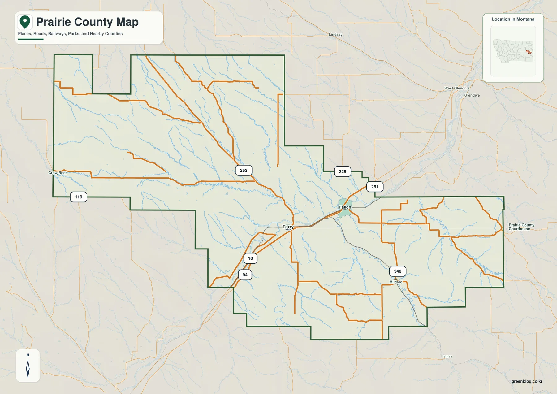
On the general county map, Terry sits slightly south of center and serves as the clearest settlement reference. Road 253 approaches the Terry area from the north and west, while roads 10 and 94 appear to the southwest and provide useful references for the lower central county.
Fallon lies east of Terry close to the same broad river valley. Roads 229 and 261 provide additional references around the narrowing central-eastern part of the county, where the large western block transitions into a long eastern extension.
Mildred appears farther southeast with Road 340 nearby. A Prairie County Courthouse label is visible near the eastern side of the map, but official county sources identify Terry as the county seat. Small labels on the static map should be treated as geographic references rather than administrative authority.
Crow Rock and northern roads help orient the western county
Crow Rock is labeled near the western boundary, with Road 119 providing a north-south reference nearby. The western section has fewer settlement names than the Terry area, and the county boundary bends repeatedly around large rural tracts.
Across the northwest and north-central interior, Road 253 and several smaller roads follow broad drainage country. The road map can look relatively empty here, but the water map reveals a dense network of tributaries that makes the terrain easier to understand.
The general map is best used for regional orientation. Current unpaved-road conditions, construction, and seasonal access should be checked through current travel information rather than inferred from the static image.
Terry is the only ranked city
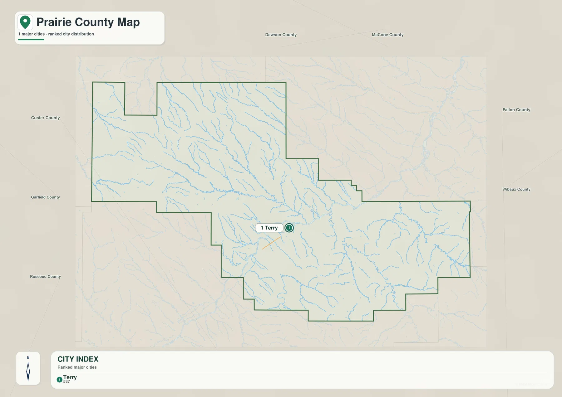
The city map contains one ranked place: Terry. Its CITY INDEX lists a value of 537. This figure is embedded in the supplied map and should not be treated as a guaranteed current population estimate. Current demographic totals should be checked through recent U.S. Census Bureau data.
Terry lies in the lower central river corridor. Surrounding labels include Dawson, McCone, Fallon, Wibaux, Custer, Garfield, and Rosebud counties, showing how Prairie County fits among the broad counties of eastern Montana.
Because Terry is the only ranked city, the map contains no connector lines or mileage labels. No straight-line or driving distance should be inferred from Terry to Fallon, Mildred, or any other place based on visual spacing alone.
Yellowstone River and Powder River define the main lowlands
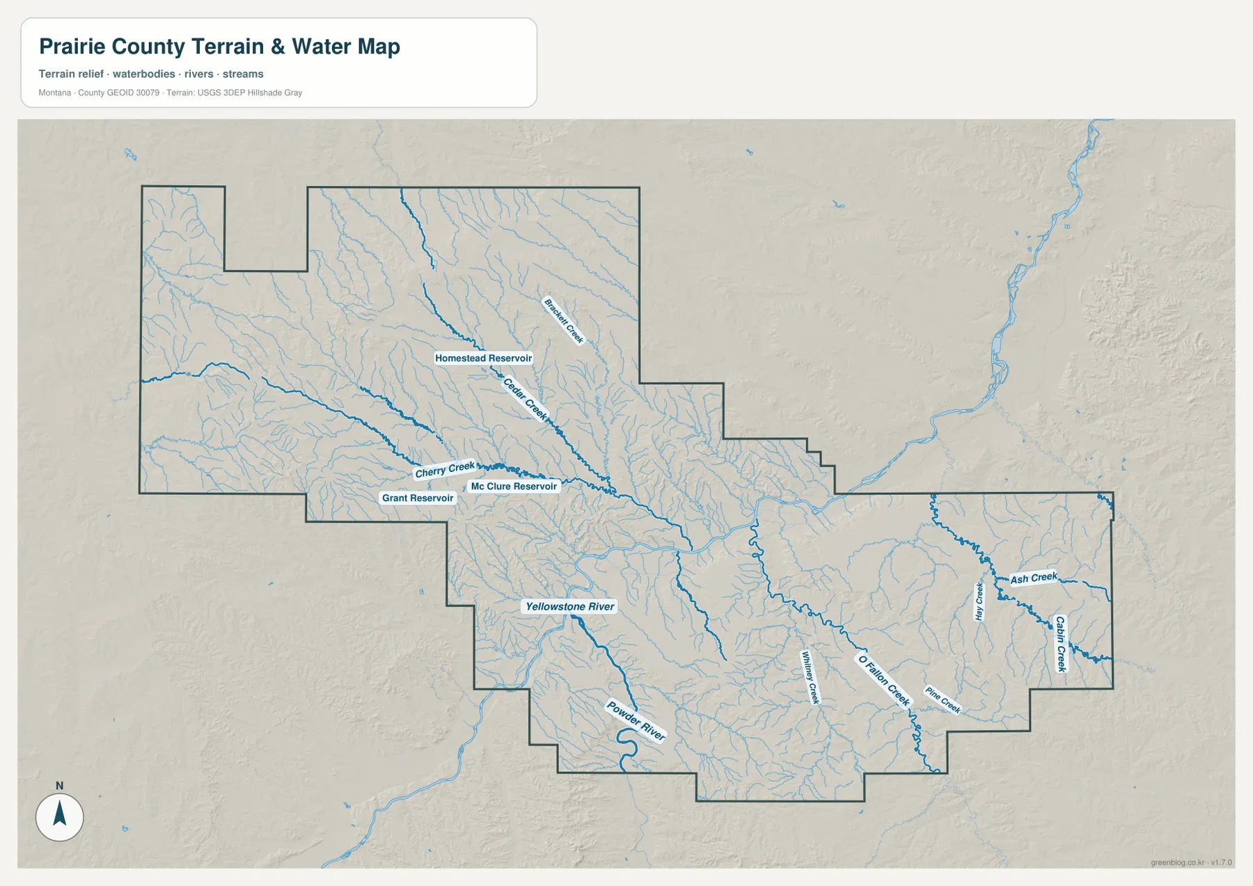
Yellowstone River is the dominant water feature across the center of Prairie County. It enters from the west, passes through the Terry-Fallon corridor, and continues east while collecting many smaller tributaries. The broad river valley is also the county’s strongest low-elevation route.
Powder River enters from the south and forms another deep low corridor before joining the larger Yellowstone system. On the elevation map, both river valleys appear in darker green than the surrounding uplands.
The terrain-and-water map is intended for geographic reference. It does not establish flood zones, water depth, parcel boundaries, water rights, navigation conditions, or safe stream crossings. Current water and access conditions should be checked through appropriate official sources.
O’Fallon Creek and eastern tributaries divide the long eastern section
O’Fallon Creek is one of the strongest labeled drainages in the eastern half. Pine Creek and Whitney Creek occupy neighboring valleys, while Hay Creek, Ash Creek, and Cabin Creek provide additional references near the far eastern side.
In the northwest, Badger Creek and Cedar Creek descend through higher terrain. Homestead Reservoir lies between these drainages, while Grant Reservoir and Mc Clure Reservoir appear farther southwest near Cherry Creek.
These water features show a clear contrast within the county. The northwest is cut by many tributaries descending from higher ground, while the center and east contain broader valleys leading toward the Yellowstone River corridor.
Elevation ranges from about 644 to 1,095 meters
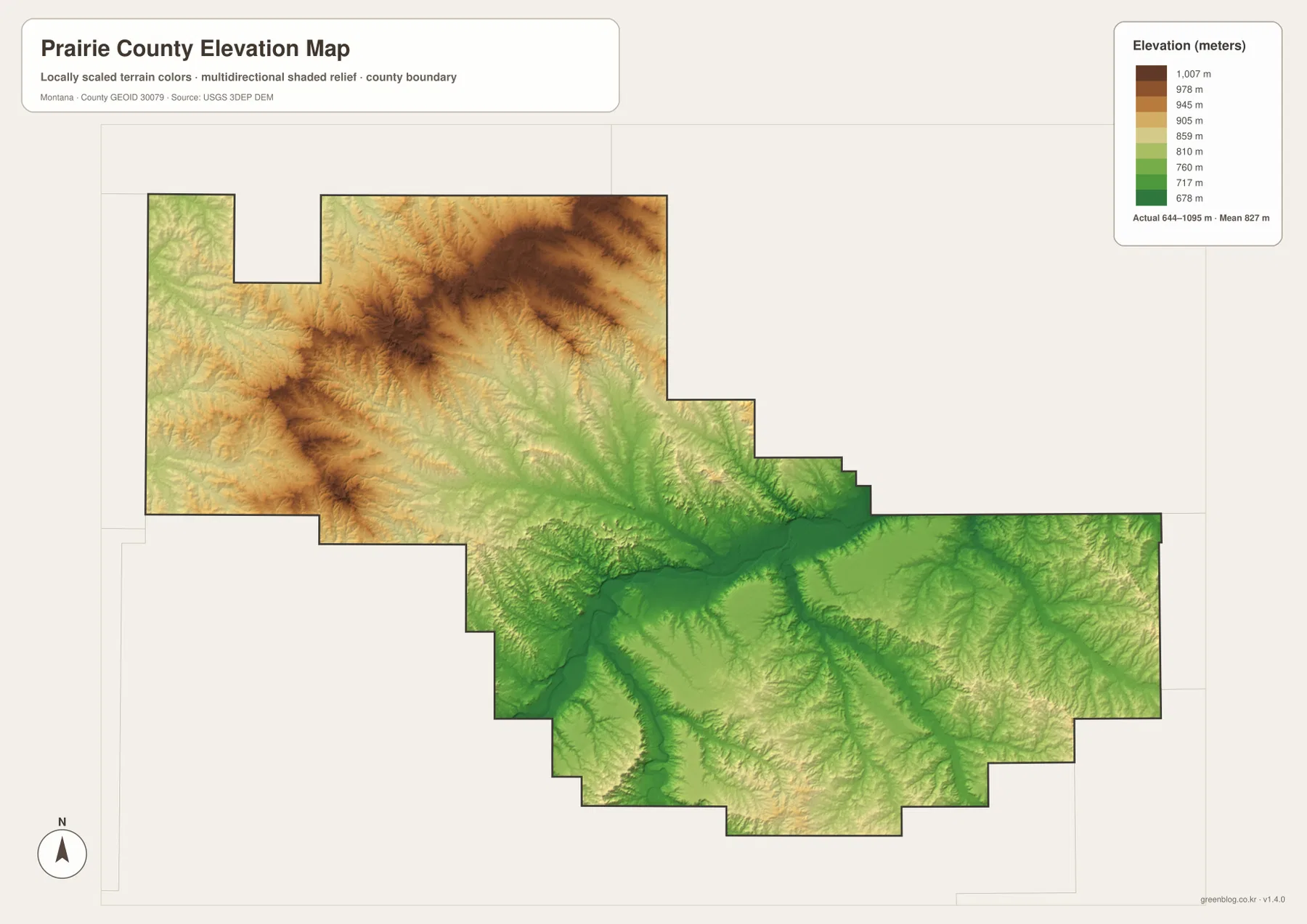
The elevation map reports an actual Prairie County range of about 644 to 1,095 meters, with a mean elevation near 827 meters. Yellowstone River and Powder River form the darkest green lowlands through the central and southern county.
The highest terrain is concentrated in the northwest and west-central uplands, where brown ridges rise above the main river valley. Badger Creek, Cedar Creek, and numerous smaller tributaries cut lower routes through this higher country toward the center.
The eastern section is generally lower than the northwest but still contains rolling divides between O’Fallon Creek and neighboring tributaries. The elevation map is intended for county-wide comparison only and should not be used as survey-grade or engineering-grade data for a specific property.
Terry and Yellowstone River provide a simple framework
A practical way to read Prairie County is to begin with Terry and Yellowstone River. Add Fallon to the east and Mildred farther southeast, then use roads 253, 261, and 340 to organize the main settled corridors. Crow Rock and Road 119 provide useful references for the western edge.
Water features provide the next layer. Yellowstone River organizes the center, Powder River the south, O’Fallon Creek the east, and Cedar and Badger creeks the northwest. Homestead, Grant, and Mc Clure reservoirs add smaller landmarks in areas with few settlement labels.
The WebP images embedded in the article are convenient for quick browsing. The high-resolution JPG files in the ZIP are better for printing or enlarging small road, creek, and reservoir labels. Because these are static reference maps, current road access and water conditions should be checked through current official information.
Frequently Asked Questions
Does the Prairie County city map show distances between cities?
No. Terry is the only ranked city on the supplied city map, so there are no connector lines, straight-line distances, or road mileages to Fallon, Mildred, or other communities.
Where is the highest terrain in Prairie County?
The elevation map shows the highest terrain mainly in the northwestern and west-central uplands. The Yellowstone River and Powder River valleys are much lower.
Can the 644–1,095 meter elevation range be used for a property or engineering project?
No. The range is a county-wide reference for comparing lower river valleys with higher uplands. Precise site elevations should come from an authoritative source such as the USGS 3D Elevation Program and, when necessary, a professional survey.
Map File Information
Download the Prairie County county, city, terrain-and-water, and elevation maps as high-resolution A3 JPG files.
- Included Files: county map, city map, terrain and water map, elevation map
- File Type: ZIP containing 4 JPG files
Related Maps
Sources and References
County government and local background are available from the official Prairie County website, which says Prairie County was formed in 1915 and identifies Terry as the county seat and only incorporated town, with Fallon and Mildred among the other communities. The Montana Association of Counties county-seat list also identifies Terry as the Prairie County seat.
Boundary and road-reference data can be checked through U.S. Census Bureau TIGER/Line Shapefiles. Hydrographic data are available from USGS National Hydrography, and elevation data through the USGS 3D Elevation Program.
Green Map creates custom-edited map images using open geographic data sources such as geoBoundaries, Natural Earth, OpenStreetMap, and government open data. These maps are edited visual materials, not raw data files, and are provided for education, documents, presentations, and graphic reference.