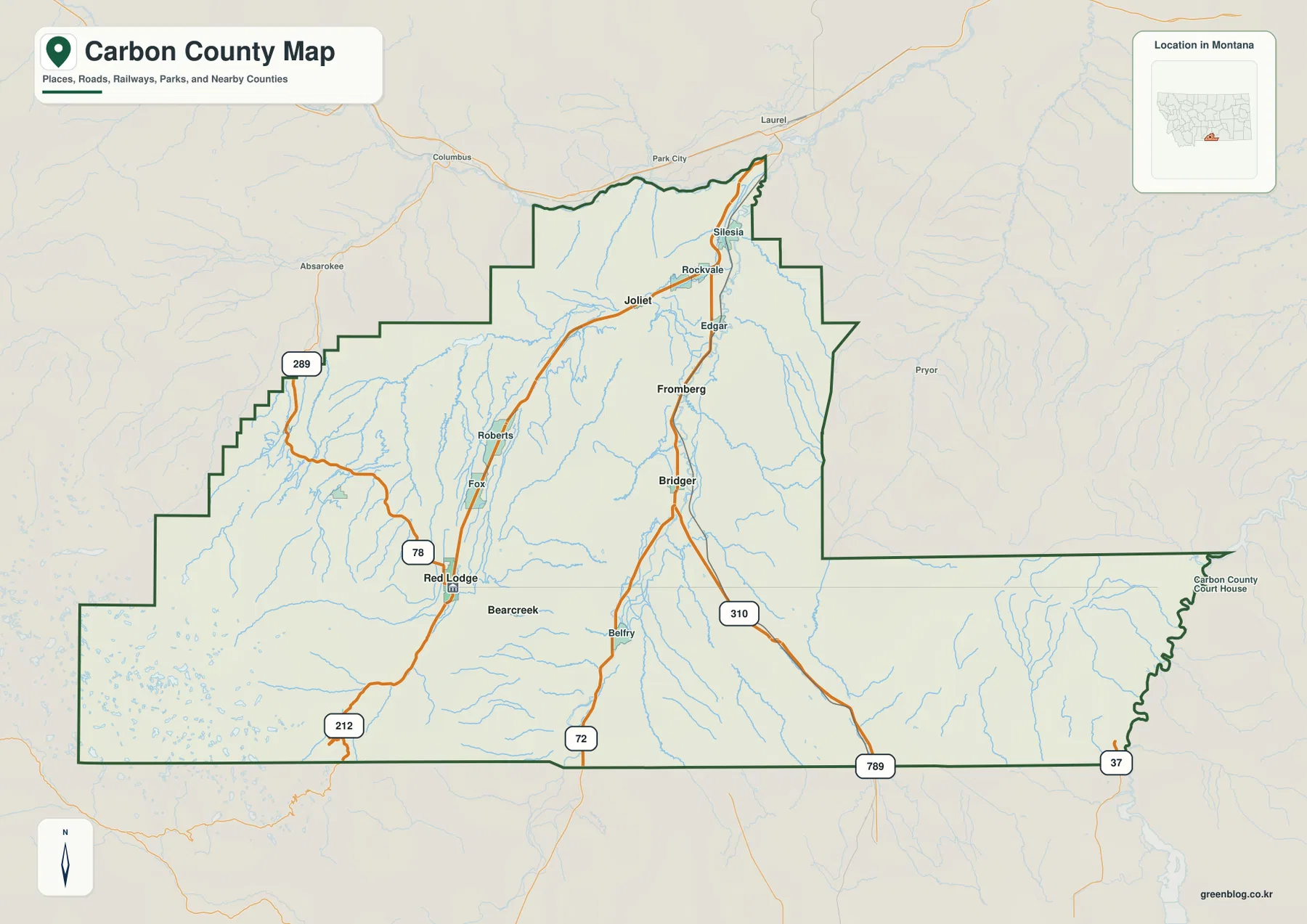
Carbon County in south-central Montana stretches from broad river valleys in the north to steep high country along the southwestern edge. Red Lodge is the easiest southwestern reference point, while Roberts and Joliet continue north through another valley and Fromberg, Bridger, and Belfry line up farther east near the Clarks Fork of the Yellowstone. The contrast becomes even sharper on the elevation map, where the southwest rises thousands of meters above the lower northern and eastern corridors. The maps shown on this page can also be downloaded together as high-resolution JPG files in the ZIP below. High-resolution map files are available for download in the section below.
The county’s official information identifies Red Lodge as the county seat and lists a string of smaller communities that match the pattern visible on the maps. Red Lodge, Roberts, and Joliet occupy the western side of the settled interior, while Fromberg and Bridger sit in the Clarks Fork valley. Bearcreek lies close to Red Lodge, and Belfry is farther south. Seeing those places together makes the county easier to understand than treating it as a single uniform block of southern Montana.
Table of Contents
Roads split into western and eastern valley routes
Red Lodge is a natural place to begin on the general county map. Montana Highway 78 runs north from the Red Lodge area toward Roberts and the road network around Joliet, while U.S. 212 continues south from Red Lodge toward the mountainous southwestern corner. The map therefore places Red Lodge close to a major transition: lower valley country extends north, but the terrain rises sharply in the opposite direction.
Joliet sits farther north near the point where local routes spread toward Silesia and Rockvale and toward the eastern side of the county. Fromberg and Bridger form another north-south sequence to the east. Route 310 continues south from Bridger, and the southern map edge also shows route numbers 72, 789, and 37. In the west, Route 289 is labeled near the county boundary. These roads help show the broad travel pattern, but current construction, closures, and seasonal conditions should be checked separately.
The county boundary is irregular, especially along the western side and the long eastern projection. Laurel, Park City, Columbus, and Absarokee appear outside the county and provide useful regional reference points. Their presence makes it easier to see how Carbon County connects with the larger Yellowstone River region even though the county’s interior roads often follow valleys rather than straight east-west lines.
Five ranked places show how settlement is divided between valleys
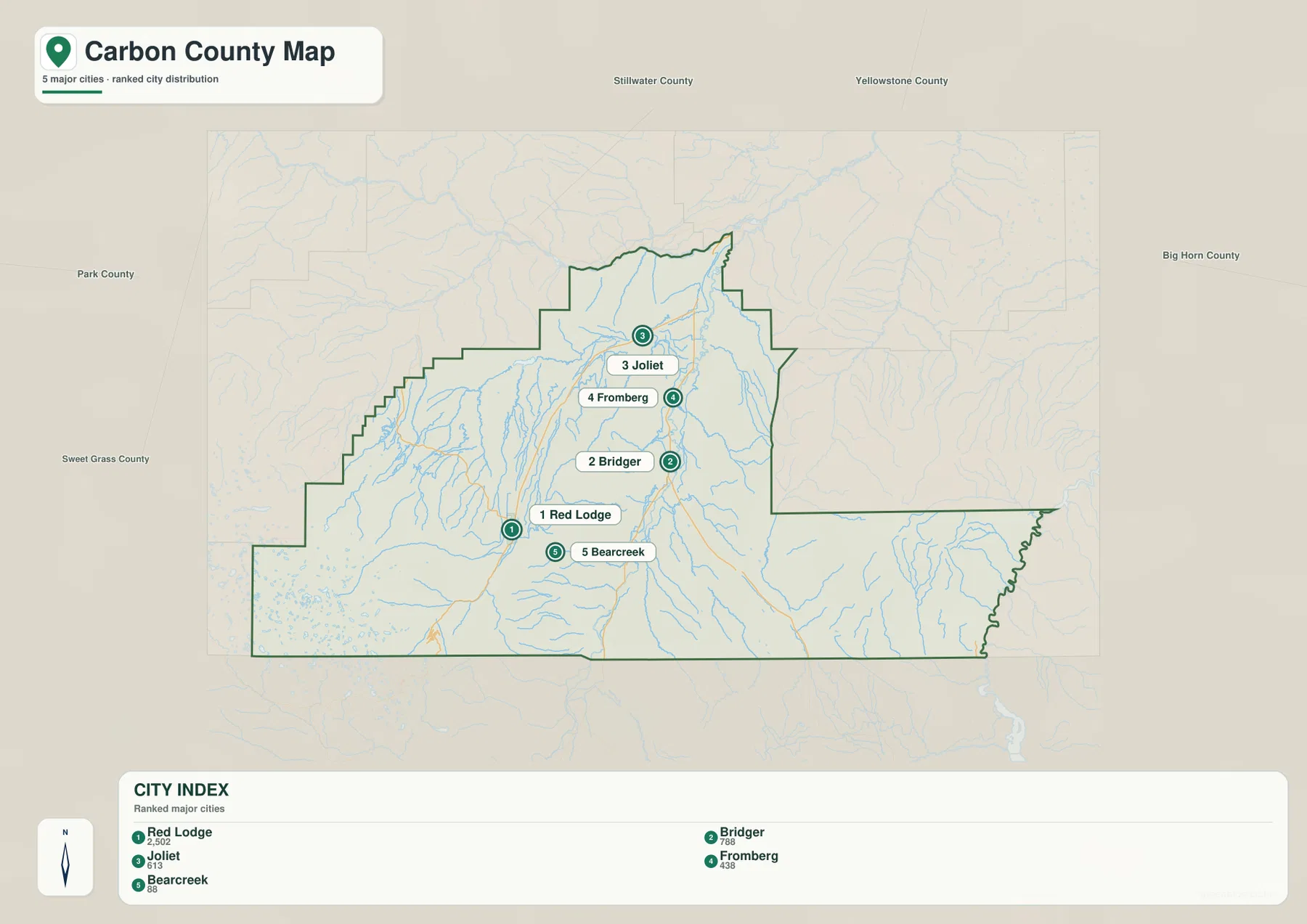
The city map highlights five ranked places: Red Lodge, Bridger, Joliet, Fromberg, and Bearcreek. Its printed city index shows values of 2,502 for Red Lodge, 788 for Bridger, 613 for Joliet, 438 for Fromberg, and 88 for Bearcreek. These are the values embedded in the supplied map and should not be treated as guaranteed current population estimates. For up-to-date demographic figures, use recent U.S. Census Bureau data.
Their locations are more useful than the ranking itself. Red Lodge and Bearcreek sit close together in the southwest, Joliet is much farther north, and Fromberg and Bridger occupy the eastern valley. That arrangement is easier to see on the simplified city view than on the road map. Once the pattern is familiar, the general county map can be used to add the smaller communities and the roads between them.
No connector lines or city-to-city distance labels are printed on this version of the city map. The spacing should therefore be read as a location reference rather than as a mileage or travel-time estimate. A trip between Red Lodge and Bridger, for example, has to follow the available valley roads rather than the straight visual gap between the two markers.
The Yellowstone, Clarks Fork, and Rock Creek define the main water corridors
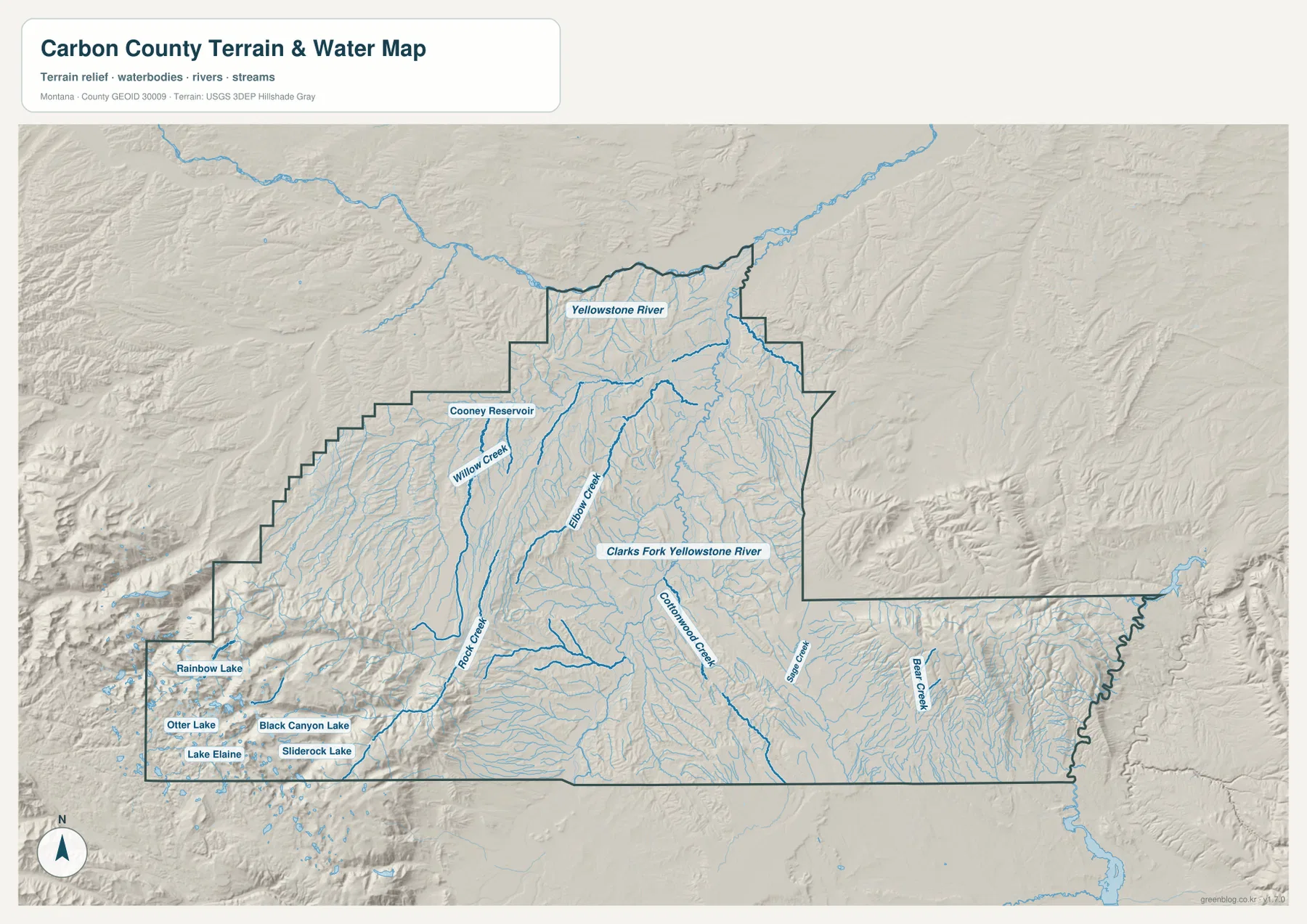
The terrain-and-water map shows the Yellowstone River along the northern side of the county. Farther south and east, the Clarks Fork Yellowstone River runs north through the broad valley associated with Bridger and Fromberg. On the western side, Rock Creek flows north from the Red Lodge area. These three waterways provide a simple framework for understanding much of the county before turning to the smaller tributaries.
Bluewater Creek and Cottonwood Creek feed the Clarks Fork side, while Sage Creek and Bear Creek appear farther southeast. Willow Creek lies west of the central interior, and numerous unnamed or smaller tributaries descend from the surrounding uplands. The map makes the drainage directions visible without requiring every creek name to be memorized: higher ground surrounds both main valleys, and streams generally descend toward the larger channels.
Cooney Reservoir is one of the easiest water bodies to identify in the northwest. In sharp contrast, the mountainous southwest contains a cluster of much smaller lakes, including Rainbow Lake, Otter Lake, Lake Elaine, Black Canyon Lake, and Sliderock Lake. Their concentration in rough relief is a strong visual cue that the southwest is a very different environment from the northern reservoir and the Clarks Fork valley. This map is not a flood-hazard, navigation, property-boundary, water-rights, or fishing-regulation product.
The southwestern corner rises above 3,000 meters
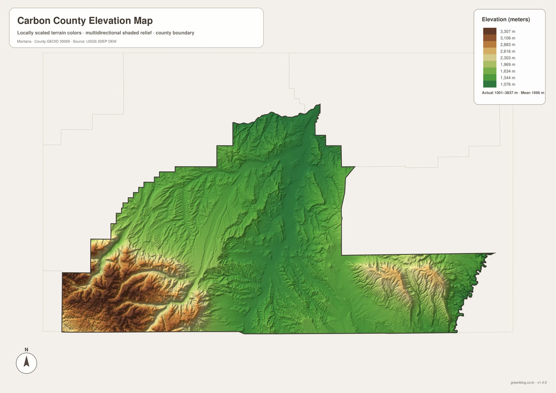
The elevation map reports an actual county range of about 1,001 to 3,837 meters, with a mean elevation near 1,696 meters. Lower green terrain dominates much of the north and the eastern river corridor, while the southwest quickly changes through yellow and brown into the highest colors on the map. The difference of more than 2,800 meters between the low and high ends explains why Carbon County can contain both open agricultural valleys and rugged alpine-looking terrain within the same boundary.
The steepest relief is concentrated southwest of Red Lodge, where ridges and deep valleys are packed closely together. The cluster of small lakes seen on the water map lies within this high country. North toward Joliet and east toward Bridger, the land is generally lower and the relief becomes less extreme, which also matches the concentration of roads and communities on the other maps.
The southeastern part of the county also contains elevated ridges, but it does not show the same broad mass of very high terrain as the southwest. The Clarks Fork valley remains visible as a lower north-south corridor through this area. The elevation map is intended for county-wide comparison, not for surveying, engineering, construction, or determining the exact elevation of a specific parcel.
Cooney Reservoir and the mountain lakes sit in very different settings
Cooney Reservoir lies in the northwestern part of Carbon County, where the surrounding terrain is far less rugged than the high country near the Wyoming line. The county’s official community guide describes Boyd as a gateway to the Cooney State Park reservoir and notes fishing, boating, and camping as local attractions. On the water map, the reservoir is easy to pick out near Willow Creek and provides a useful landmark for the northwestern interior.
The lakes in the southwest occupy the opposite kind of landscape. Rainbow Lake, Otter Lake, Lake Elaine, Black Canyon Lake, and Sliderock Lake appear among steep ridges and tightly spaced valleys. Their small size and high setting distinguish them from Cooney Reservoir even at a quick glance. Comparing these water bodies is one of the clearest ways to see how much the county changes from north to southwest.
Red Lodge links the road map with the high-country map
A practical way to connect the four views is to start at Red Lodge. On the county map, it sits near Highway 78 and U.S. 212. On the city map, it is the southwestern member of the five ranked places. Rock Creek runs nearby on the water map, and the elevation map shows the ground rising dramatically just to the southwest. The same location therefore ties roads, settlement, water, and relief together without requiring separate mental maps.
Carbon County’s official guide describes Red Lodge as the county seat and as a gateway toward Yellowstone National Park via the Beartooth Highway. That context fits the map well: U.S. 212 heads from Red Lodge toward the county’s highest terrain. A static county map is useful for regional orientation, but anyone planning to travel into mountain country should check current road openings, weather, and seasonal restrictions before departure.
The WebP images embedded in the article are convenient for quick browsing. The high-resolution JPG files in the ZIP are better for printing or enlarging smaller place names and road labels. Because these are static reference maps, changing conditions such as road closures, recreation access, or reservoir operations should be confirmed with current official information.
Frequently Asked Questions
Which map is best for comparing Red Lodge and Bridger?
Use the general county map if you want the roads and smaller communities as well as the two towns. Red Lodge is in the southwest and Bridger is in the eastern valley, with Fromberg between the northern and southern parts of that corridor. The city map is cleaner if you only need the relative positions of the five ranked places.
How do the Clarks Fork Yellowstone River and Yellowstone River differ on the map?
The Yellowstone River runs along the northern side of the county, while the Clarks Fork Yellowstone River comes north through the eastern and central part of Carbon County. Both are labeled on the terrain-and-water map, so their separate positions and directions are easy to compare.
Can the 1,001–3,837 meter elevation range be used for a specific property or engineering job?
No. The range is a county-wide reference for comparing low valleys with high mountain terrain. Precise elevation for a property, construction site, or engineering project should come from an authoritative dataset such as the USGS 3D Elevation Program and, when required, a professional survey.
Map File Information
Download the Carbon County county, city, terrain-and-water, and elevation maps as high-resolution A3 JPG files.
- Included Files: county map, city map, terrain and water map, elevation map
- File Type: ZIP containing 4 JPG files
Related Maps
Sources and References
County-seat, community, history, and local geographic background are available from the official Carbon County Discover Carbon County page. Boundary and road-reference data can be checked through U.S. Census Bureau TIGER/Line Shapefiles.
Hydrographic reference data are available from USGS National Hydrography, and elevation data can be checked through the USGS 3D Elevation Program.
Green Map creates custom-edited map images using open geographic data sources such as geoBoundaries, Natural Earth, OpenStreetMap, and government open data. These maps are edited visual materials, not raw data files, and are provided for education, documents, presentations, and graphic reference.