Blaine County stretches across north-central Montana from the Milk River corridor near Chinook and Harlem to much higher country in the south. The county map places its principal towns and roads in a long north-south landscape: U.S. 2 follows the northern river valley, Fort Belknap Agency sits southeast of Harlem, and Hays and Lodge Pole lie much farther south near the mountain country. The maps on this page show those relationships through roads, settlements, water features, and elevation, and the same map set can be downloaded below as high-resolution JPG files in a ZIP archive. High-resolution map files are available for download in the section below.
For a first orientation, start with Chinook and Harlem. Chinook is farther west, Harlem is to the east, and Zurich sits between them along the same northern corridor. Hogeland and Turner are separated from the river towns across the northern plains, while most of the county extends a long distance south toward Hays, Lodge Pole, and the higher terrain. That contrast between a relatively concentrated northern corridor and a much larger rural southern interior is one of the clearest features of Blaine County.
Table of Contents
U.S. 2 and the Milk River tie the northern towns together
The general county map shows U.S. 2 running through Chinook, Zurich, and Harlem while the Milk River follows a similar east-west course across the north-central part of the county. This makes the river corridor the easiest reference for locating the county’s main towns. Chinook sits toward the western side of the corridor, Zurich occupies the middle stretch, and Harlem is farther east near the road leading toward Fort Belknap Agency.
Several state and local route numbers branch away from this corridor. Routes 325 and 529 appear near Chinook, while 241 and 338 extend north of Harlem toward the broad plains around Hogeland and Turner. Turner Colony is labeled separately in the northeast. The road network is not an urban grid; long rural segments separate communities, and the spacing on the map should be treated as geographic orientation rather than a substitute for current driving directions or road-condition information.
Southeast of Harlem, the map labels Fort Belknap Agency and Fort Belknap Critical Care close to U.S. 2. Blaine County’s official website describes Chinook as the county seat and notes that the Milk River crosses the north-central part of the county from east to west. That official description matches the strongest visual pattern on the map: most of the prominent northern settlement and transportation features gather along the lower river corridor.
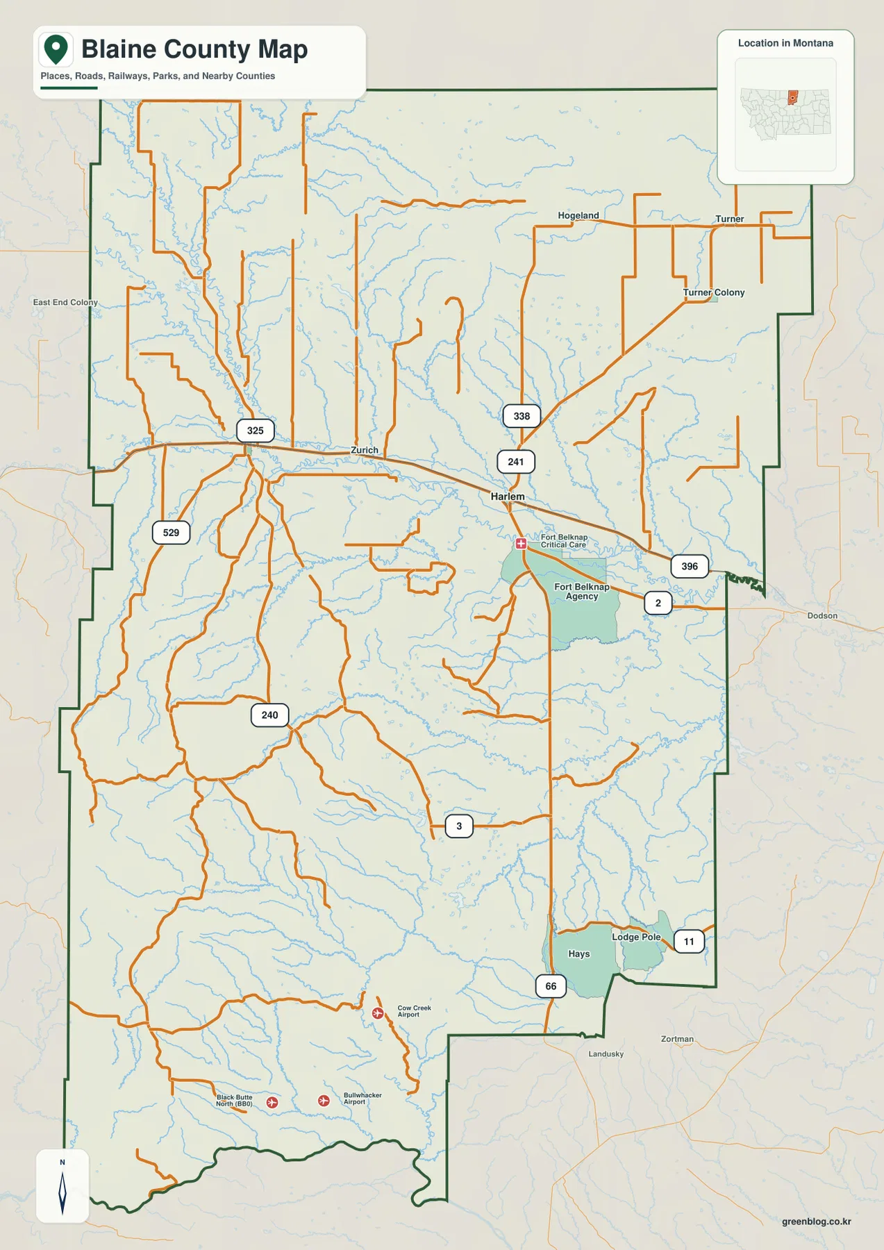
The city map emphasizes how strongly settlement is concentrated in the north
The simplified city map highlights only Chinook and Harlem. Its ranked city index lists Chinook at 1,353 and Harlem at 822. Those figures are values printed on the supplied map and should not be treated as live population estimates. Their main purpose here is to show the relative size and placement of the two incorporated towns represented in this map package.
Both markers sit in the northern part of Blaine County, but they are not adjacent. Chinook is farther west and Harlem is farther east, with a wide network of tributaries entering the Milk River around them. The southern half of the county contains no comparable ranked city marker on this map, so the difference between the populated northern corridor and the sparsely settled southern interior is visually immediate.
This city view is useful for a quick comparison, but it intentionally omits the smaller communities and most route labels. For travel toward Fort Belknap Agency, Hays, or Lodge Pole, the full county map is more informative because it shows the roads that leave the Milk River corridor and continue through the uplands. The city map should therefore be read as a location summary rather than a mileage or travel-time diagram.
Battle Creek and the southern tributaries reveal two different water landscapes
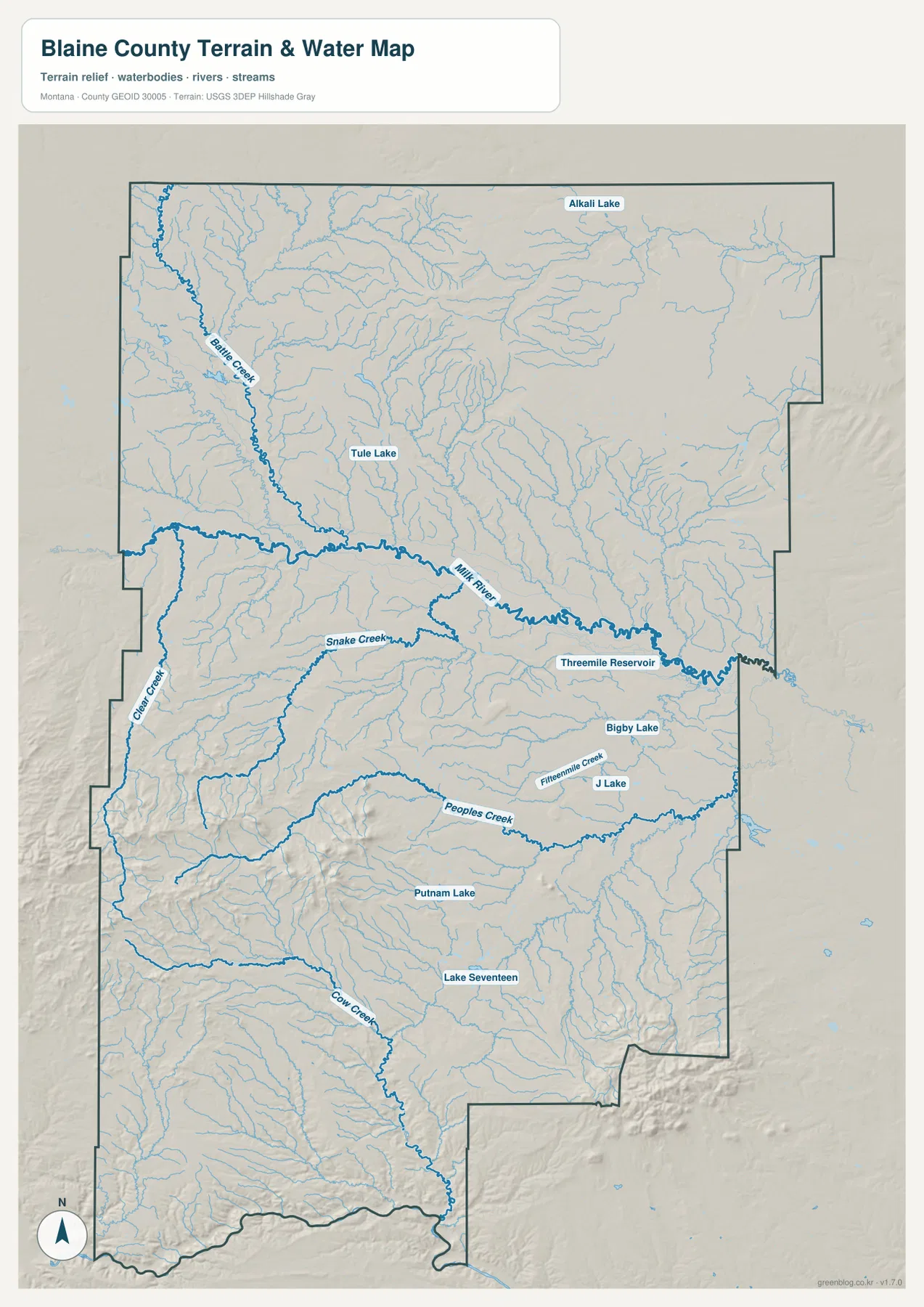
The terrain-and-water map makes the Milk River the dominant northern water feature. It crosses the county from west to east just north of the center, while Battle Creek descends from the northwest and joins the river corridor. Tule Lake appears north of the Milk River in the central-western portion, and Alkali Lake is labeled farther north. These features create a useful set of reference points for the northern plains beyond Chinook and Harlem.
South of the Milk River, the drainage becomes more varied. Snake Creek runs across the west-central area, and Peoples Creek forms a long eastward course through the southern half. Clear Creek follows the western side, while Fifteenmile Creek appears closer to J Lake and Bigby Lake in the east-central area. The map shows many smaller tributaries feeding these named streams, making the southern half look much more dissected than the broad low river corridor to the north.
Farther south, Cow Creek winds toward the lower part of the county, with Putnam Lake and Lake Seventeen providing additional landmarks. A practical way to use this map is to find the Milk River first and then trace one major tributary at a time. Battle Creek helps orient the northwest, Peoples Creek helps organize the southern middle, and Cow Creek provides a recognizable reference farther south.
Fort Belknap connects the river corridor with Hays and Lodge Pole
Fort Belknap Agency lies southeast of Harlem, creating an important transition between the Milk River corridor and the much larger southern part of the county. The Fort Belknap Indian Community identifies the reservation as the homeland of the Nakoda and Aaniiih Nations and describes Hays and Lodge Pole as communities near the Little Rocky Mountains at the southern end of the reservation. On the supplied map, Hays and Lodge Pole appear close together in the southeastern part of Blaine County, well south of the U.S. 2 towns.
Route 66 is labeled near Hays, and Route 11 reaches the eastern side near Lodge Pole. Unlike the northern corridor, where U.S. 2 links several places along a relatively direct line, the southern roads cross broad uplands and creek valleys before reaching these communities. Seeing the whole county boundary at once makes the distance from Harlem to the southern settlements much clearer than a local street map would.
Blaine County’s official description also notes that the Fort Belknap Indian Reservation occupies part of the southeastern county. Because this is an active tribal homeland and government area, a general map is only a starting point for visitors. Current access, services, events, and administrative information should be checked through Blaine County and the Fort Belknap Indian Community when those details matter.
Elevation rises from the Milk River lowlands to two southern mountain areas
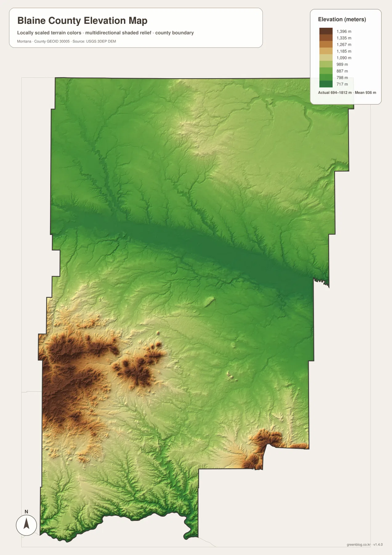
The elevation map reports an actual range of about 694 to 1,812 meters, with a mean elevation of about 936 meters. The lowest broad band follows the Milk River across the north-central portion of the county and appears in the darker green shades. That low corridor corresponds closely with the location of Chinook, Harlem, and U.S. 2 on the other maps.
The most dramatic high terrain appears in the southwest, where brown and dark-brown relief rises sharply above the surrounding plains. Blaine County’s official website identifies the Bears Paw Mountains with the southwestern part of the county. A second high area appears near the southeastern edge, consistent with the Little Rocky Mountains described by the county and the Fort Belknap Indian Community. Between these two elevated areas, the central south contains lower rolling terrain cut by numerous creeks.
Comparing the elevation and water maps helps explain why so many streams lead away from the southern uplands toward lower valleys. The pattern is useful for county-wide orientation, but the color scale should not be used as survey data for a specific road, parcel, or building site. For precise point elevations or engineering work, use an authoritative source such as the USGS 3D Elevation Program.
Choose the map that matches the question you are trying to answer
Use the general county map when you need to compare Chinook, Harlem, Fort Belknap Agency, Hays, Lodge Pole, and the main numbered roads in one view. The city map is cleaner when the question is simply where Chinook and Harlem sit relative to the county boundary. For rivers, creeks, and lakes, the terrain-and-water map provides far more detail, especially for Battle Creek, Peoples Creek, and the many southern tributaries.
The elevation map is the best companion when you want to understand why the Milk River corridor looks broad and low while the southwest and southeast rise into much rougher terrain. The WebP images in the article are optimized for convenient browser viewing, while the downloadable JPG files preserve more detail for printing and close inspection. These are static reference maps, so live road conditions, agency hours, access restrictions, and other changing information should always be checked with the relevant official source.
Frequently Asked Questions
Where are Chinook and Harlem within Blaine County?
Both towns are in the northern Milk River corridor. Chinook is farther west and Harlem is farther east, with Zurich between them along U.S. 2. Comparing the city map with the full county map also shows how far these towns are from Hays and Lodge Pole in the southeast.
Do the Milk River and Peoples Creek follow the same part of the county?
No. The Milk River crosses the north-central county from west to east, while Peoples Creek runs through the southern half. Battle Creek, Snake Creek, and Cow Creek add other major reference lines, so the northern river corridor and southern uplands have visibly different drainage patterns.
Can the 694–1,812 meter elevation range be used as site-specific survey data?
No. The map is designed to compare county-wide terrain, not to provide engineering or parcel-level elevations. For an exact location, use authoritative elevation data such as the USGS 3D Elevation Program or a professional survey where appropriate.
Map File Information
Download the Blaine County county, city, terrain-and-water, and elevation maps as the original high-resolution JPG files.
- Included Files: county map, city map, terrain and water map, elevation map
- File Type: ZIP containing 4 JPG files
Related Maps
Sources and References
County geography, Chinook’s role as the county seat, the Milk River corridor, and the Bears Paw and Little Rocky mountain references can be checked on the official Blaine County website. Background on Fort Belknap, Hays, Lodge Pole, and the Nakoda and Aaniiih Nations is available from the Fort Belknap Indian Community.
Boundary and road reference data are available through U.S. Census Bureau TIGER/Line Shapefiles. Water features can be checked against USGS National Hydrography, and elevation data are available through the USGS 3D Elevation Program.
Green Map creates custom-edited map images using open geographic data sources such as geoBoundaries, Natural Earth, OpenStreetMap, and government open data. These maps are edited visual materials, not raw data files, and are provided for education, documents, presentations, and graphic reference.