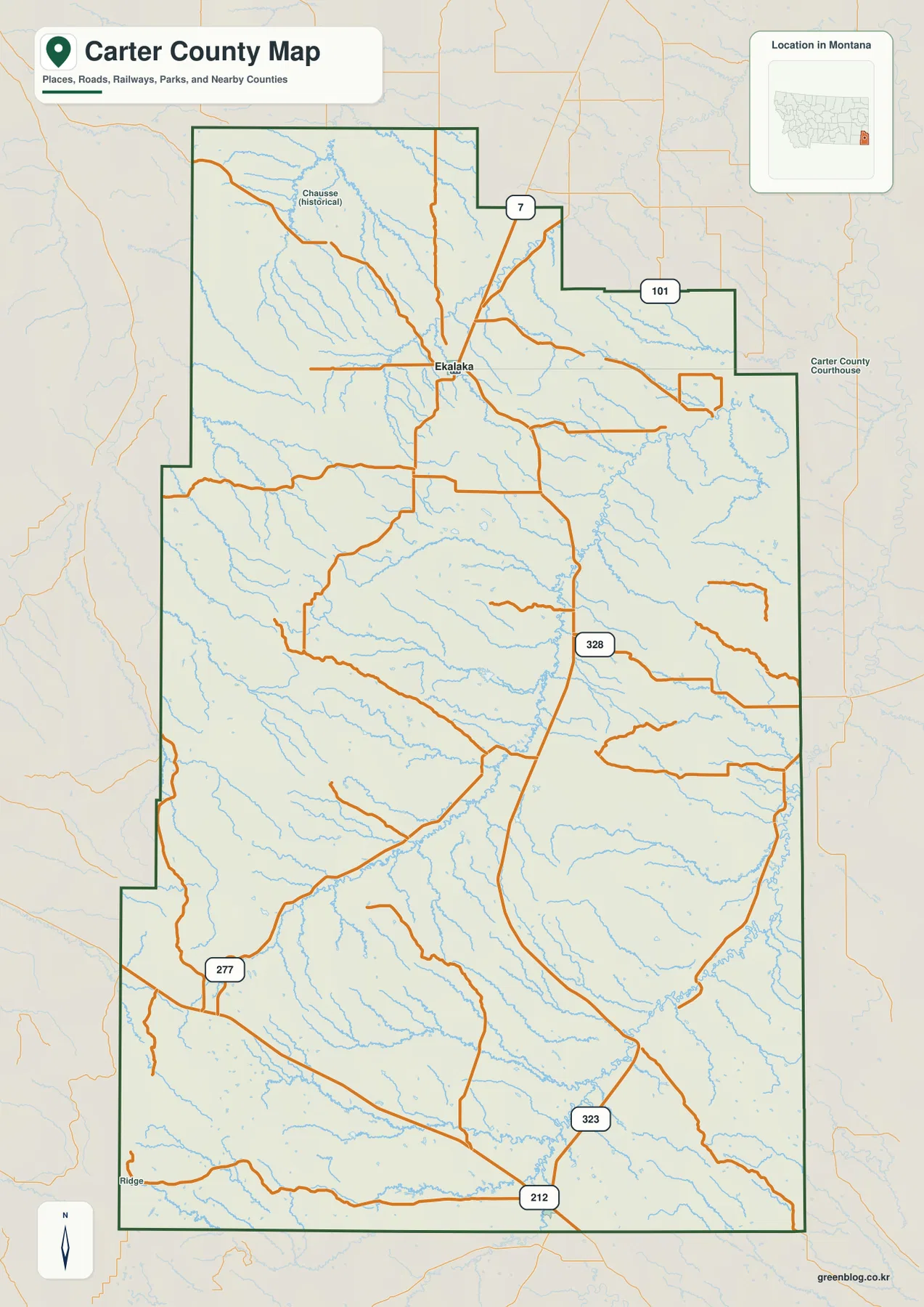
Carter County occupies the far southeastern corner of Montana, where Ekalaka is the main mapped community and a sparse road network crosses broad creek country. Route 7 leaves Ekalaka to the north, Route 101 reaches east, and Route 328 runs a long distance south through the interior. Waterways are even more numerous than roads: Boxelder Creek cuts across the middle of the county, while the Little Missouri River becomes the strongest reference in the southeast. The maps on this page are available for on-screen reference, and high-resolution JPG versions can be downloaded together in the ZIP below. High-resolution map files are available for download in the section below.
The county is easier to understand as a large rural landscape than as a chain of towns. Ekalaka anchors the northern half, but the boundary continues far south to U.S. 212 and Route 323. Dozens of small tributaries cross the open interior, and the elevation surface shows isolated uplands rising above lower creek valleys rather than one continuous mountain range. Starting with Ekalaka, Boxelder Creek, and the Little Missouri River gives a simple framework for the rest of the map.
Table of Contents
Ekalaka anchors the northern road network
On the general county map, Ekalaka sits near the middle of the northern half and serves as the clearest orientation point. Route 7 runs north from town, Route 101 heads east toward the county boundary, and Route 328 continues south through the interior. Several smaller roads branch from these routes, so the pattern looks like a loose network centered on Ekalaka rather than a dense grid.
The northern boundary steps inward and outward in several places, and the road network follows a landscape filled with narrow drainages. A historical place label, Chausse, appears northwest of Ekalaka on the full county map, but the separate city map highlights only Ekalaka as a ranked major city. That difference is useful: the general map retains more local reference labels, while the city view strips the county down to its primary settlement marker.
Farther south, Route 328 continues toward Route 323 and U.S. 212 near the lower part of the county. Route 277 appears in the southwest. These route numbers make the county’s long north-south scale easier to see, but they should not be read as real-time travel information. Surface conditions, maintenance, weather, and seasonal access can change, particularly on local roads away from the main numbered routes.
The city view emphasizes how isolated Ekalaka is within the county
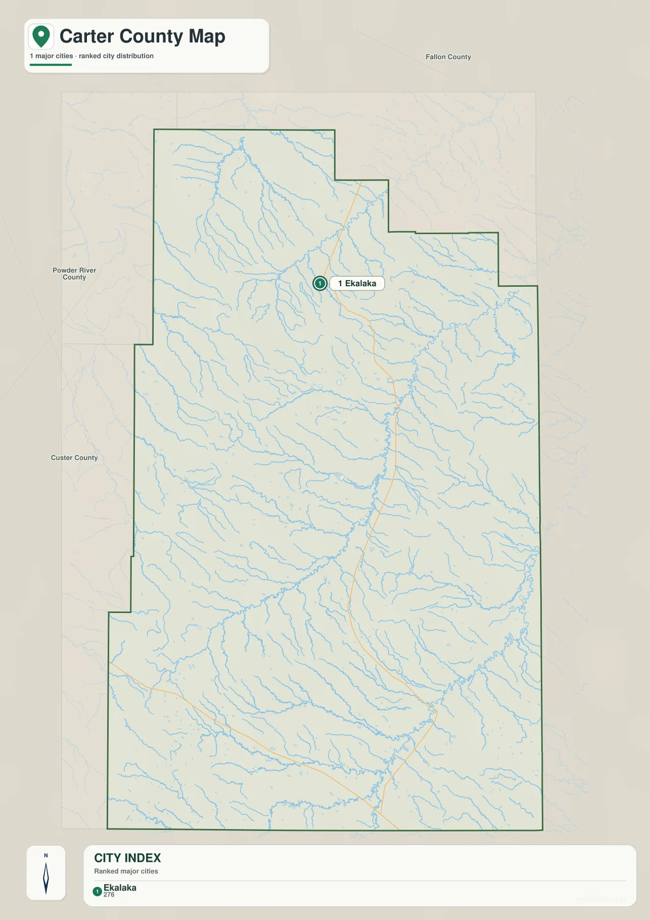
The city map ranks only one major place, Ekalaka, and prints a value of 276 in the city index. That figure is the value used in the supplied map rather than a guarantee of the newest population estimate. Readers who need current population data should consult recent U.S. Census Bureau releases instead of treating the map index as a live demographic source.
Because only one city marker is shown, the map gives a clear impression of scale. Ekalaka lies in the northern half while a large portion of Carter County extends south without another ranked city marker. The east and west sides are also broad, and the many creek lines become more visually prominent than settlement names. This makes the city view useful for understanding why roads and natural features are important reference points in the county.
There are no city-to-city connector lines or distance labels on this map. It should therefore be used to locate Ekalaka within Carter County, not to estimate mileage or travel time. For the position of U.S. 212, Route 323, Route 277, or the smaller northern roads, the general county map provides the necessary detail.
Boxelder Creek provides the clearest water reference through the middle
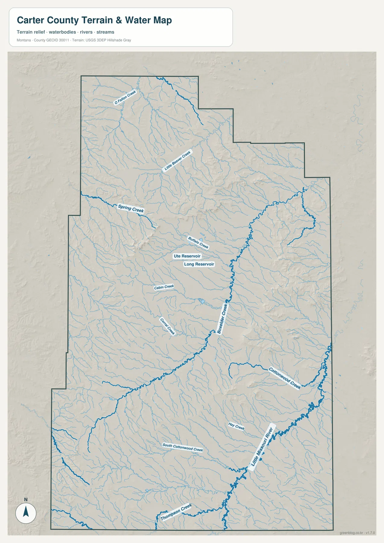
The terrain-and-water map makes Boxelder Creek one of the county’s most useful landmarks. It crosses a large part of central Carter County and receives numerous smaller tributaries. Once Boxelder Creek is located, Cabin Creek, Corral Creek, Buffalo Creek, and other nearby names become much easier to place relative to the center of the county.
The northern section contains O’Fallon Creek and Little Beaver Creek, while Spring Creek runs across the west-central area. Buffalo Creek approaches the central drainage near two small named water bodies, Ute Reservoir and Long Reservoir. The reservoirs are modest features on the full map, but their labels help identify the middle of a landscape where many creeks otherwise look similar.
Much of the county contains unnamed or lightly labeled tributaries. They repeatedly descend from local uplands and merge into larger channels, producing a branching pattern across the map. A practical way to read this detail is to begin with Boxelder Creek, then work outward to the named tributaries rather than trying to identify every small drainage at once.
The Little Missouri River becomes the key landmark in the southeast
In southeastern Carter County, the Little Missouri River is drawn as a strong blue channel and is easier to follow than most other waterways. It occupies the lower eastern part of the county near the southern boundary and provides a natural reference for the surrounding drainages. Cottonwood Creek, Hay Creek, and Thompson Creek appear near this larger river system.
Cottonwood Creek approaches from the east-central side, while South Cottonwood Creek crosses part of the southern interior. These channels reveal a landscape of broad shallow valleys separated by rolling or broken uplands. Comparing the water map with the road map also shows why numbered routes do not simply run straight across the county: they pass through terrain already divided by many creek valleys and ridges.
The water map is a geographic reference, not a flood map, navigation chart, property survey, or regulatory guide. It does not establish water depth, ownership, fishing rules, or current crossing conditions. Anyone planning field access or making land-related decisions should use current agency or property-specific information in addition to this county overview.
Elevation ranges from roughly 848 to 1,350 meters
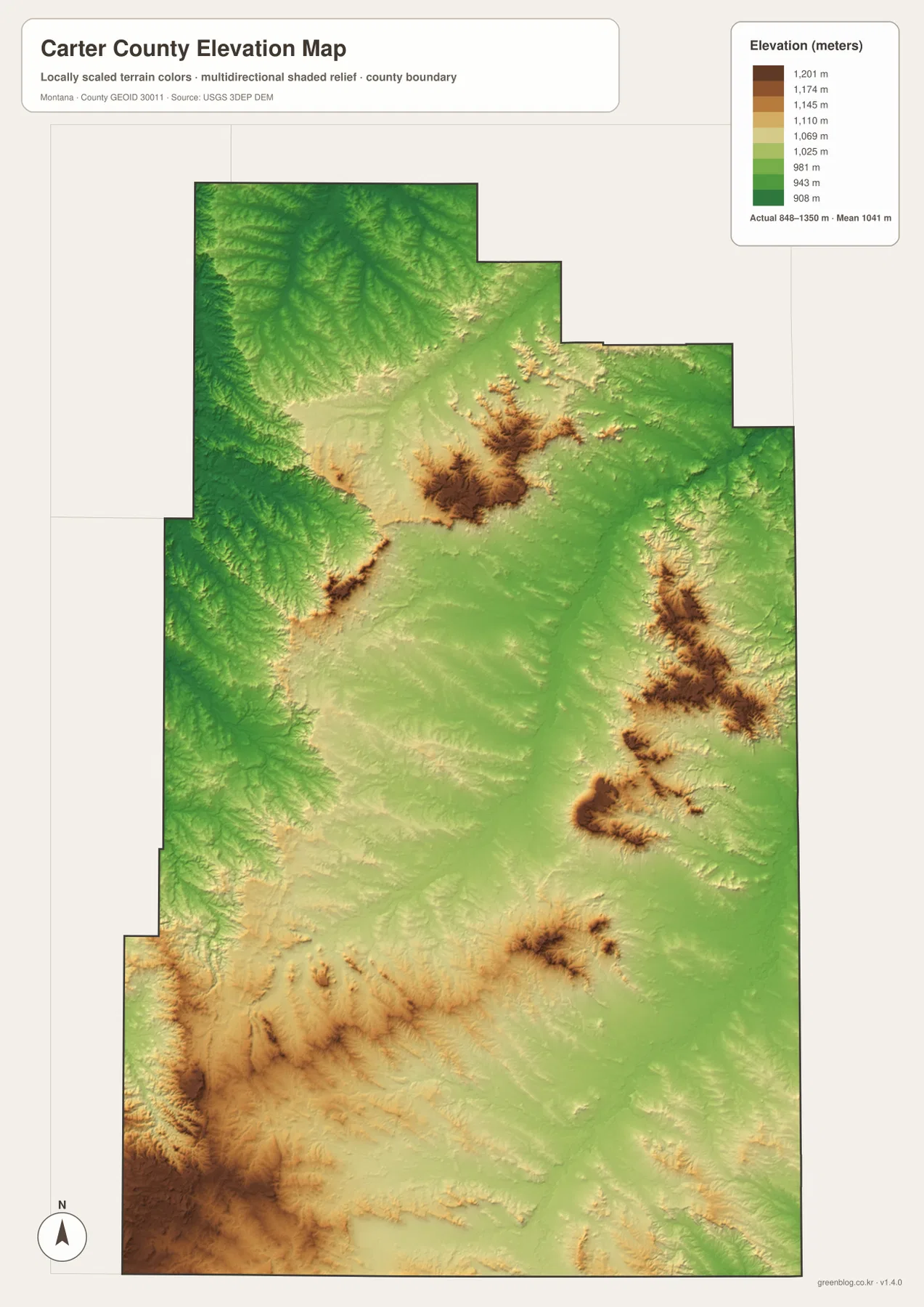
The elevation map reports an actual range of about 848 to 1,350 meters and a mean elevation near 1,041 meters. Lower areas appear in green, while higher ground shifts through yellow and brown. The total relief is moderate compared with western Montana’s high mountain counties, yet the internal contrast is strong enough to separate creek valleys from isolated uplands and rougher hills.
The broadest concentration of high terrain appears along the southwestern edge, where brown shades cover a substantial area. Additional high blocks stand out in the north-central and eastern parts of the county. Between them, lower green and pale-yellow surfaces form wider corridors. Those lower areas correspond well with many of the channels visible on the terrain-and-water map.
Rather than one mountain chain dominating the county, Carter County shows repeated patches of higher ground separated by lower drainages. This helps explain the irregular routes of local roads and creeks. The elevation map is intended for county-wide comparison only; it is not precise enough for engineering, construction, parcel work, or determining the exact elevation of a specific site.
The long southern half changes the scale of the county
A quick look centered on Ekalaka can make Carter County seem smaller than it is. Following Route 328 south toward Route 323 and U.S. 212 reveals how far the county continues below its main city. The Little Missouri River occupies part of this lower landscape, and the combination of road and river references makes the north-to-south distance much easier to appreciate.
The same is true east to west. Numerous creeks and isolated uplands break up what might otherwise look like open plains on a simple boundary map. The elevation map shows higher brown patches scattered between lower green corridors, while the water map fills many of those corridors with tributaries. Reading the two together gives a clearer picture of Carter County than settlement names alone can provide.
The WebP images embedded in the article are designed for quick browsing. The high-resolution JPG files in the ZIP are more suitable for printing or zooming into small road and creek labels. Because the maps are static references, changing conditions such as road access, creek levels, or land-entry restrictions should be confirmed through current official or local information.
Frequently Asked Questions
Where is Ekalaka on the Carter County map?
Ekalaka is shown near the center of the county’s northern half. Route 7 runs north, Route 101 heads east, and Route 328 continues south, making Ekalaka the easiest starting point for orienting yourself to the rest of Carter County.
Are Boxelder Creek and the Little Missouri River in the same part of Carter County?
They are in the same county but dominate different areas. Boxelder Creek crosses much of the central interior, while the Little Missouri River is most prominent in the southeast and near the southern boundary. Locating those two waterways first makes the smaller tributaries easier to place.
Can the 848–1,350 meter elevation range be used for a specific property or engineering project?
No. The range is a county-wide reference for comparing lower creek valleys with higher uplands. Precise elevation for property, construction, or engineering work should come from an authoritative dataset such as the USGS 3D Elevation Program and, when necessary, a professional survey.
Map File Information
Download the Carter County county, city, terrain-and-water, and elevation maps as high-resolution A3 JPG files.
- Included Files: county map, city map, terrain and water map, elevation map
- File Type: ZIP containing 4 JPG files
Related Maps
Sources and References
County boundary and road-reference data can be checked through U.S. Census Bureau TIGER/Line Shapefiles. Current statewide road and travel information is available from the Montana Department of Transportation.
Hydrographic reference data are available from USGS National Hydrography, and elevation data can be checked through the USGS 3D Elevation Program.
Green Map creates custom-edited map images using open geographic data sources such as geoBoundaries, Natural Earth, OpenStreetMap, and government open data. These maps are edited visual materials, not raw data files, and are provided for education, documents, presentations, and graphic reference.