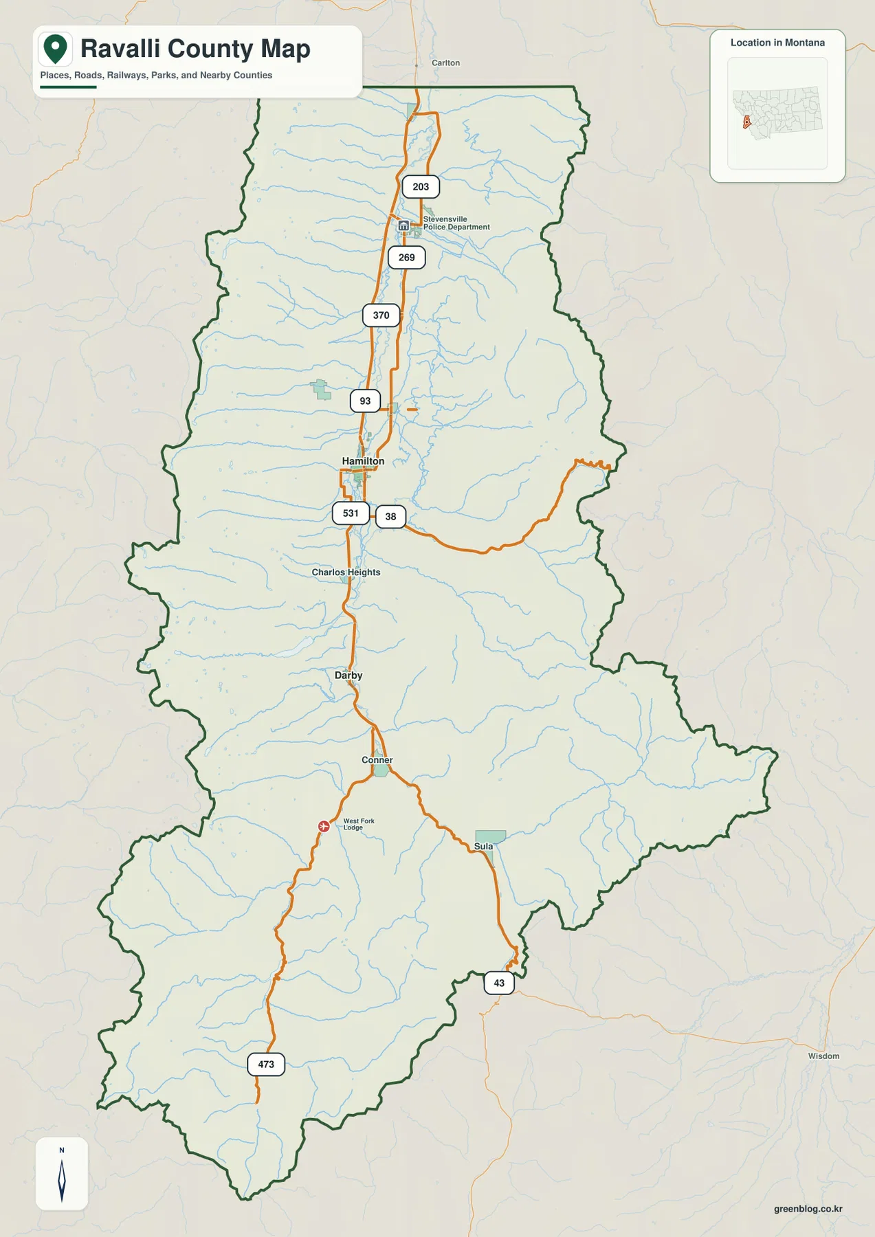
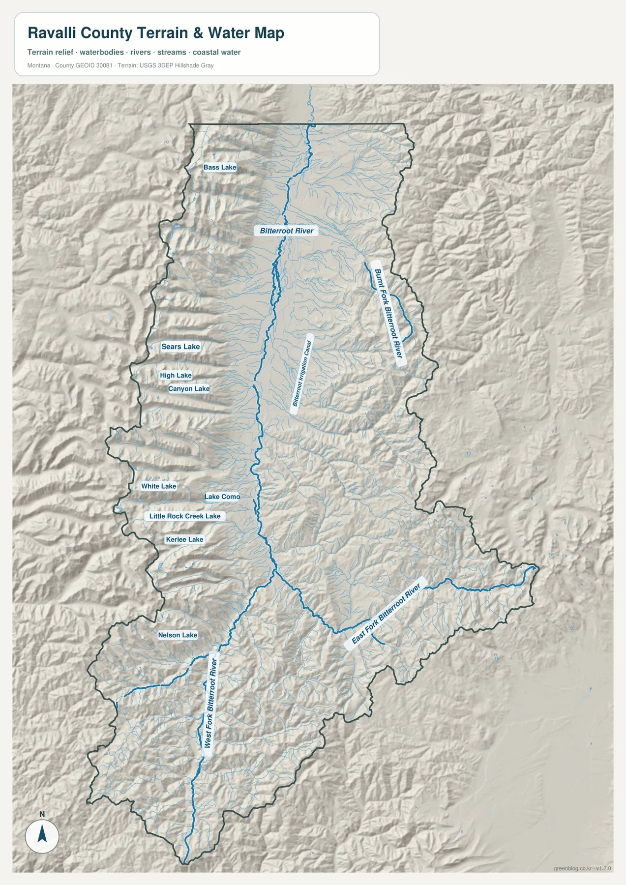
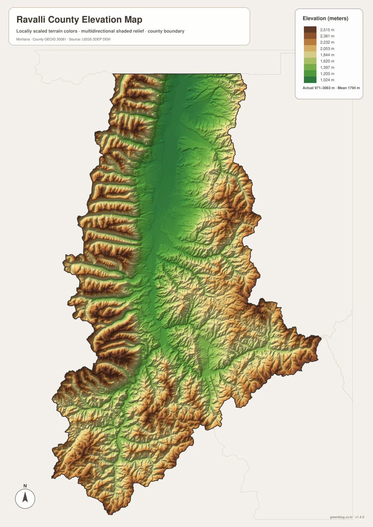
Ravalli County follows the long Bitterroot Valley of western Montana from the Stevensville area south through Hamilton and Darby toward Conner and Sula. U.S. 93 provides the clearest north-south road reference, while routes 203, 269, 370, 531, 38, 43, and 473 branch toward surrounding mountain country. The terrain-and-water map adds Bitterroot River, West Fork and East Fork Bitterroot River, Burnt Fork Bitterroot River, and a chain of high mountain lakes. The elevation map makes the landscape especially clear: the central valley remains low and green while steep mountain ranges rise on both sides. High-resolution JPG versions of the maps are available together in the download ZIP below.
Ravalli County’s official materials identify Hamilton as the county seat and list Stevensville, Pinesdale, Hamilton, and Darby among the county’s incorporated communities. County planning material describes the Bitterroot Range on the west, the Sapphire Range on the east, and the fertile Bitterroot Valley between them. The supplied maps show the same structure clearly, with most major roads and towns concentrated in the central lowland and much steeper terrain along the western and eastern margins.
Table of Contents
U.S. 93 forms the main north-south corridor
On the general county map, U.S. 93 is the strongest continuous road reference. Stevensville anchors the north, Hamilton occupies the central valley, and Darby lies farther south. Charlos Heights appears between Hamilton and Darby, reinforcing the long linear settlement pattern along the valley floor.
Route 203 is labeled near Stevensville, Route 269 farther south, and Route 370 north of Hamilton. Around Hamilton, Route 531 and Route 38 branch toward surrounding areas, with Route 38 extending far into the eastern mountain side.
South of Darby, Conner provides another valley reference before roads split toward Sula and the southwestern mountains. Routes 43 and 473 help locate the southern and southwestern county. The map is designed for geographic orientation, so current construction, winter closures, and unpaved mountain-road conditions should be checked separately.
Hamilton connects to Stevensville, Pinesdale, and Darby by straight-line distance
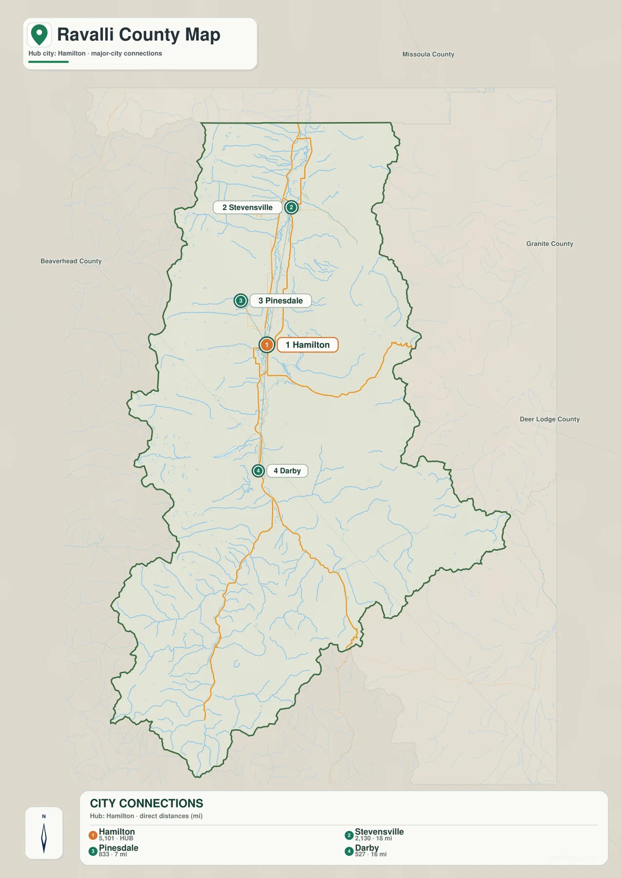
The city-connections map uses Hamilton as the hub. Its printed index lists Hamilton at 5,101, Stevensville at 2,130, Pinesdale at 833, and Darby at 527. These are values embedded in the supplied map and should not be treated as guaranteed current population estimates. Current demographic totals should be checked through recent U.S. Census Bureau data.
The map labels Stevensville 18 miles from Hamilton, Pinesdale 7 miles away, and Darby 16 miles away. All three values are straight-line distances rather than driving mileage. Actual trips follow U.S. 93 and local roads and can therefore be longer.
Stevensville lies north of Hamilton, Pinesdale to the northwest, and Darby to the south. Together they show how the county’s major communities align with the long Bitterroot Valley. The city map is useful for relative position and direct-distance comparison, not for road routing.
Bitterroot River runs through the central valley
Bitterroot River is the dominant water feature through the center of the county. It follows the same broad north-south valley that contains the largest towns and U.S. 93, creating the main lowland corridor from the southern river forks toward the north.
Numerous short tributaries descend from the Bitterroot Range on the west, while streams from the Sapphire Mountains enter from the east. Burnt Fork Bitterroot River is one of the most prominent eastern tributaries and provides a strong geographic reference east of the main valley.
The terrain-and-water map is intended for geographic reference. It does not establish flood zones, water depth, parcel boundaries, water rights, navigation conditions, or safe stream crossings. Current water and access conditions should be checked through appropriate official sources.
The river forks and western lakes divide the southern mountains
West Fork Bitterroot River approaches from the south and creates a long low corridor through the southwestern mountain region. East Fork Bitterroot River comes from the southeast and joins the broader Bitterroot system near the central-southern valley. These two forks provide especially useful references around Conner and Sula.
The western mountains contain many named lakes. Bass Lake appears in the north, Sears Lake, High Lake, and Canyon Lake farther south, followed by White Lake, Lake Como, Little Rock Creek Lake, and Kerlee Lake. Nelson Lake provides another landmark in the southwest.
Lake Como is one of the clearest western water bodies on the map. Together with the smaller mountain lakes, it helps distinguish individual basins and canyons where major roads and town names are sparse. Actual access and seasonal road conditions should be checked separately.
Elevation ranges from about 971 to 3,063 meters
The elevation map reports an actual Ravalli County range of about 971 to 3,063 meters, with a mean elevation near 1,794 meters. The Bitterroot Valley forms a long green lowland down the center, while the Bitterroot Range to the west and Sapphire Mountains to the east rise rapidly through yellow and brown.
The western side is especially rugged, with tightly spaced ridges and narrow drainages descending toward the valley. Many of the mountain lakes shown on the water map occupy high basins within this terrain. The eastern mountains are also extensive, although some sections display broader slopes than the steep western front.
In the south, West Fork and East Fork Bitterroot River remain visible as lower corridors through surrounding mountains. The elevation map is intended for county-wide comparison only and should not be used as survey-grade or engineering-grade data for a specific property.
Hamilton and Bitterroot River provide a simple framework
A practical way to read Ravalli County is to begin at Hamilton and follow U.S. 93 north toward Stevensville and south toward Darby and Conner. Pinesdale provides a close northwestern city reference, while Sula helps locate the southern mountain approach. Route 38 and Route 43 provide additional eastward references.
Water features provide the next layer. Bitterroot River organizes the central valley, West and East Fork Bitterroot River explain the south, and Burnt Fork Bitterroot River helps with the eastern mountains. Bass Lake, Lake Como, Canyon Lake, and Nelson Lake provide useful landmarks in the rugged west.
The WebP images embedded in the article are convenient for quick browsing. The high-resolution JPG files in the ZIP are better for printing or enlarging small road, river, and lake labels. Because these are static reference maps, current road access, river levels, and seasonal restrictions should be checked through current official information.
Frequently Asked Questions
Are the Hamilton-to-Stevensville, Pinesdale, and Darby distances driving distances?
No. The city map shows 18 miles to Stevensville, 7 miles to Pinesdale, and 16 miles to Darby as straight-line distances from Hamilton. Actual driving distances follow U.S. 93 and local roads and can be longer.
Where is the highest terrain in Ravalli County?
The elevation map shows high mountain terrain on both sides of the Bitterroot Valley, with especially steep ridges along the western Bitterroot Range and extensive high country in the eastern Sapphire Mountains.
Can the 971–3,063 meter elevation range be used for a property or engineering project?
No. The range is a county-wide reference for comparing the low central valley with surrounding mountains. Precise site elevations should come from an authoritative source such as the USGS 3D Elevation Program and, when necessary, a professional survey.
Map File Information
Download the Ravalli County county, city, terrain-and-water, and elevation maps as high-resolution A3 JPG files.
- Included Files: county map, city map, terrain and water map, elevation map
- File Type: ZIP containing 4 JPG files
Related Maps
Sources and References
County government and local background are available from the official Ravalli County website and a Ravalli County 911 Center document, which identifies Hamilton as the county seat and lists Stevensville, Pinesdale, Hamilton, and Darby as incorporated communities. A Ravalli County planning document describes the Bitterroot Range to the west, Sapphire Range to the east, and Bitterroot Valley between them.
Boundary and road-reference data can be checked through U.S. Census Bureau TIGER/Line Shapefiles. Hydrographic data are available from USGS National Hydrography, and elevation data through the USGS 3D Elevation Program.
Green Map creates custom-edited map images using open geographic data sources such as geoBoundaries, Natural Earth, OpenStreetMap, and government open data. These maps are edited visual materials, not raw data files, and are provided for education, documents, presentations, and graphic reference.