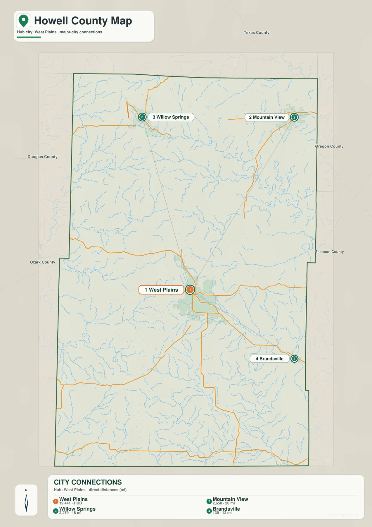
Howell County sits in the southern Missouri Ozarks, where West Plains is the main urban reference and deep stream valleys divide a broad upland landscape. Mountain View and Willow Springs occupy the north, Pomona lies between Willow Springs and West Plains, and South Fork sits southwest of the county’s main city. U.S. 60 and U.S. 63 provide the strongest highway references, while the water map highlights the Eleven Point River system in the north and Spring River tributaries farther south. The elevation layer spans roughly 188 to 476 meters. High-resolution JPG versions of the same map themes can be downloaded together in the ZIP for printing or offline use. High-resolution map files are available for download in the section below.
The easiest way to read Howell County is to begin at West Plains and then compare the north and south. North toward Willow Springs and Mountain View, the terrain rises into stronger Ozark ridges and is cut by the Eleven Point drainage. South of West Plains, long valleys associated with Spring Creek and the Spring River forks create a different but still highly dissected landscape.
Table of Contents
West Plains and U.S. 63 provide the clearest orientation
West Plains is the largest mapped urban area and the practical starting point for the county. U.S. 63 runs through the city and continues north toward Pomona and Willow Springs. Route 14 crosses the area north of West Plains, while Route 17 and Route 160 help orient the southern and southwestern sections. The Howell County Courthouse is also labeled in West Plains, reinforcing the city’s role as the county’s administrative center.
Traveling north from West Plains brings the map through Pomona toward Willow Springs. Mountain View lies farther northeast along U.S. 60, while South Fork is southwest of West Plains. The general map is designed for county-scale orientation rather than live navigation, so current road conditions and final driving routes should still be checked separately.
The city layer uses West Plains as a straight-line distance hub
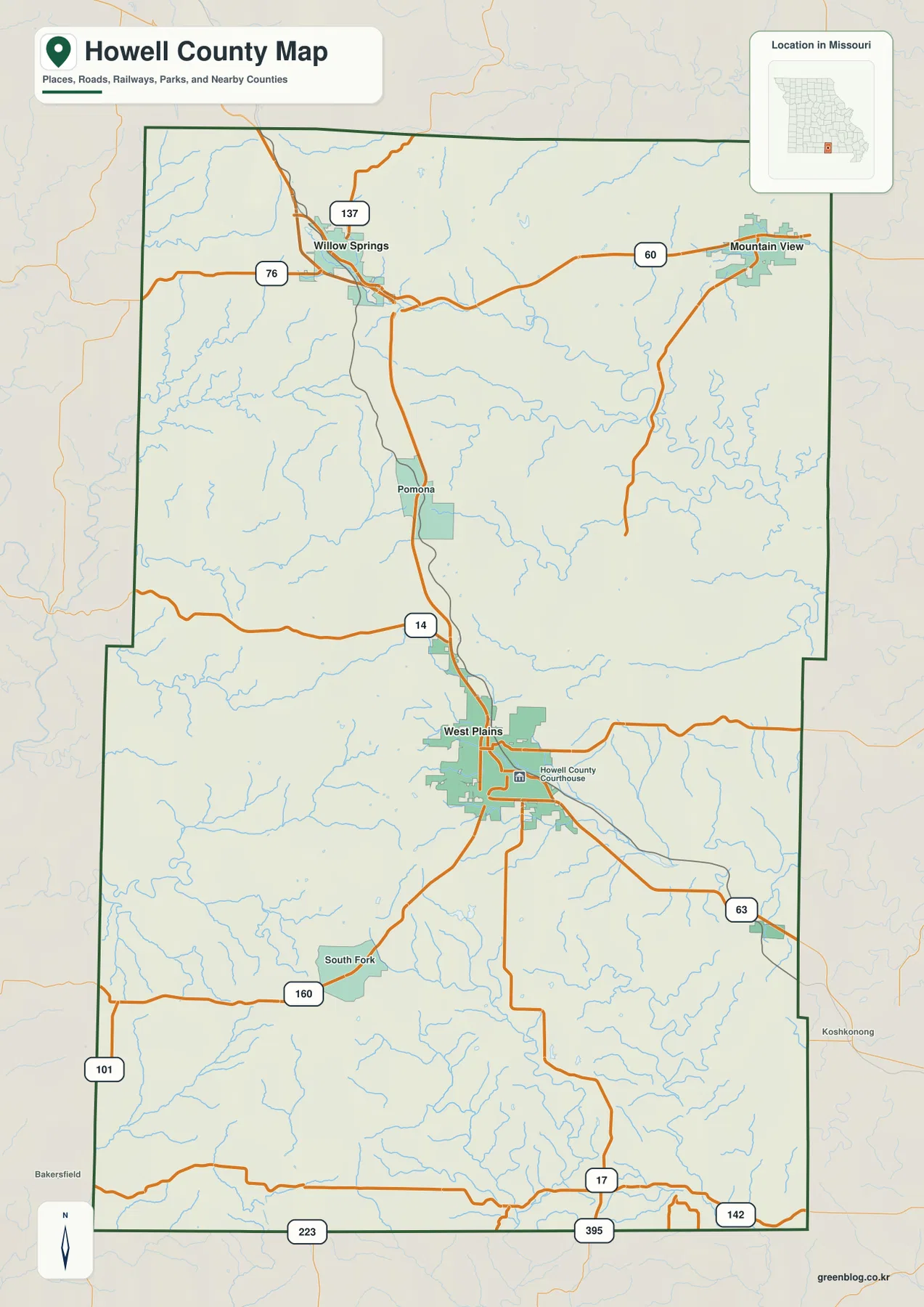
The city map is a connector-distance map rather than a simple ranked distribution. West Plains is labeled as the HUB, with direct-distance links to Mountain View, Willow Springs, and Brandsville. The map reports approximately 20 miles to Mountain View, 18 miles to Willow Springs, and 12 miles to Brandsville.
Those distances are straight-line measurements, not driving mileage. Roads through the Ozarks curve around ridges and stream valleys, so real routes can be noticeably longer. The connector view is best used to compare direction and approximate separation: Mountain View is northeast of West Plains, Willow Springs is north, and Brandsville is southeast. Other numeric values shown beside city names belong to the map dataset and should not automatically be treated as current official population counts.
Willow Springs and Mountain View anchor the northern uplands
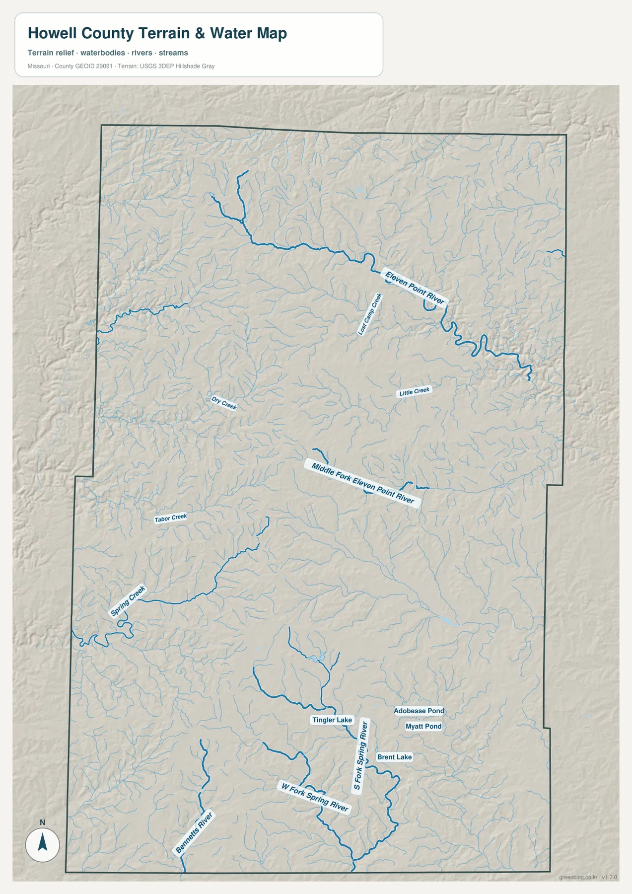
Willow Springs appears in the northwestern portion of the county near Route 76, Route 137, and U.S. 60. Missouri Department of Conservation identifies the area near Willow Springs in northeastern Howell County as the origin of the Eleven Point River. Moving from the road map to the water layer makes that relationship easy to see.
Mountain View lies farther northeast along U.S. 60. The terrain between the two towns is dominated by high Ozark ridges cut by many short tributaries. On the elevation map, the northern county is heavily shaded in tan and brown, while stream valleys descend sharply into green. The two towns occupy the same broad northern region but are separated by different drainage corridors.
Eleven Point River carves the major northeastern valley
Eleven Point River is the most prominent watercourse in northern Howell County. It begins in the northern uplands and bends generally east and southeast, gathering numerous tributaries along the way. Lost Camp Creek and Little Creek are among the labeled tributaries that help readers match the main river with surrounding valleys.
Missouri Department of Conservation describes the Eleven Point as originating near Willow Springs and flowing southeast across northern Howell County before continuing through Oregon County. The supplied elevation map shows the same river corridor as a deep green valley cut into much higher surrounding terrain. The water layer is a geographic reference and should not be used as a real-time flood or river-stage product.
Middle Fork Eleven Point River divides the north-central interior
Middle Fork Eleven Point River runs through the north-central part of Howell County south of the main Eleven Point corridor. Dry Creek and many smaller tributaries occupy the surrounding uplands. This separate drainage helps explain the complex terrain east and northeast of Pomona.
On the elevation map, the Middle Fork valley forms a long lower strip between higher ridges. Short tributaries branch from both sides, leaving a strongly dissected surface. What looks like open rural space on the road map becomes a dense pattern of valleys and uplands when the water and elevation layers are compared.
Spring Creek and the Spring River forks shape the south
The southern half of Howell County contains a different group of waterways. Spring Creek crosses the western and central-southern area, while South Fork Spring River and North Fork Spring River drain farther southeast. Bennett’s River is also labeled near the southwestern edge and provides another useful reference for the lower part of the county.
Tabor Creek lies north of Spring Creek, and several small named water bodies appear in the southeast, including Tingle Lake, Brent Lake, Myatt Pond, and Adobesse Pond. These smaller features do not control the county-wide drainage pattern, but they are useful fixed points when matching local areas between map layers.
Elevation ranges from about 188 to 476 meters
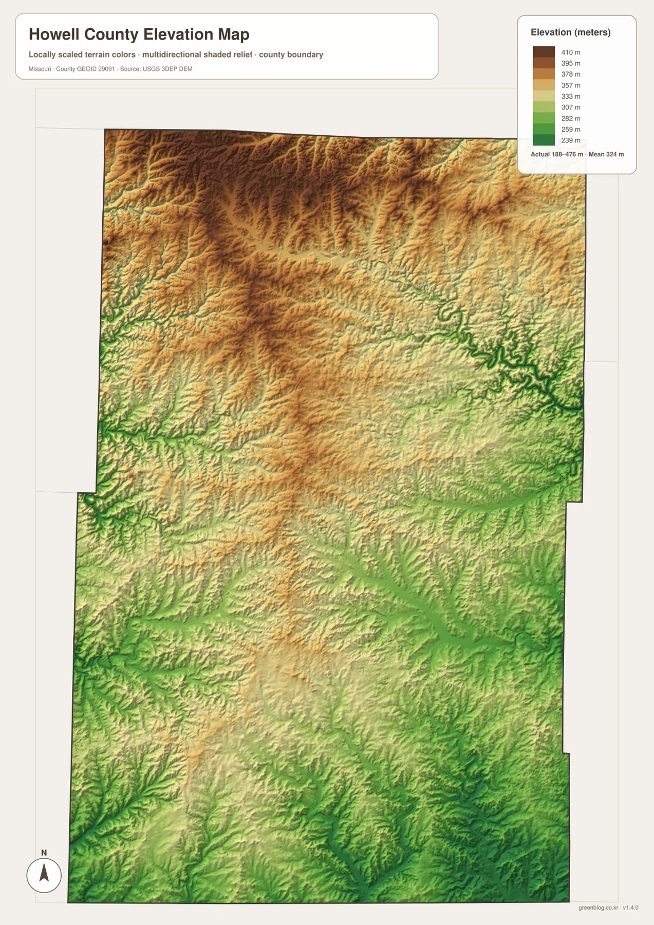
The elevation map reports an actual mapped range of approximately 188 to 476 meters, with a mean near 324 meters. The highest terrain is concentrated broadly in the north and northwest, where dark brown and tan ridges dominate the map. The Eleven Point River system cuts deeply into those uplands and appears as a much lower green corridor.
The southern half contains more green and yellow overall, but it is not flat. Spring Creek and the Spring River forks carve long narrow valleys, while ridges remain between them. The result is a county with substantial local relief across a large area. This map is useful for county-scale terrain comparison and should not be treated as survey-grade or engineering-grade elevation data.
Traveling north from West Plains reveals a major terrain transition
West Plains sits in the southern half of the county within a comparatively broad settled area. Moving north toward Pomona and Willow Springs, the elevation map shows increasingly strong upland relief. Stream valleys deepen, ridge crests become more prominent, and the landscape around the Eleven Point system is much more sharply cut.
The northeastern route toward Mountain View shows a similar contrast. High ground and low tributary valleys alternate closely, and the Eleven Point corridor eventually creates a deep lower path toward the east. Looking at the connector map alone gives direction and distance, but adding the water and elevation layers explains the terrain between the towns.
County government and local services are centered in West Plains
Howell County’s official government website provides county services and commission information from West Plains. The Howell County Commission is listed at 35 Court Square, and its responsibilities include county property, roads and bridges, budgeting, and other public business. This makes West Plains both the main map reference and the practical administrative center.
University of Missouri Extension also maintains its Howell County office in West Plains on Bill Virdon Boulevard. The office provides agriculture, 4-H, and community resources. Readers can use the map for location context and then consult the official county and Extension pages for current contacts, hours, and services.
Choosing the right downloadable map
Use the general county map for towns and major highways. The city connections map is best for comparing the straight-line direction and separation of Mountain View, Willow Springs, and Brandsville from West Plains. The terrain-and-water layer is useful for the Eleven Point River, Middle Fork, Spring Creek, and Spring River tributaries, while the elevation map shows the strongest contrast between high uplands and deeply incised valleys.
The ZIP contains high-resolution JPG versions of the same map themes shown on the page. They are useful for enlarging labels, printing a reference sheet, or comparing layers side by side. The files are intended for general geographic reference and do not replace live navigation, flood warnings, legal boundary surveys, or professional elevation measurements.
Frequently Asked Questions
What is the easiest place to use as a reference in Howell County?
West Plains is the clearest starting point. U.S. 63 and several major roads meet there, county government is centered in the city, and it provides an easy reference for Mountain View, Willow Springs, Pomona, and South Fork.
Are the 12, 18, and 20 mile labels on the city map driving distances?
No. They are direct straight-line distances from West Plains to Brandsville, Willow Springs, and Mountain View. Actual road mileage can be longer because routes curve through Ozark terrain.
What elevation range does the Howell County map show?
The elevation layer shows an actual range of about 188 to 476 meters, with a mean near 324 meters. The north and northwest are generally higher, while major river and creek valleys form lower green corridors.
Map File Information
Download the map files associated with this page for reference, printing, and compatible visual projects.
- Included Files: Use only the versions confirmed in the article and supplied images
- File Type: Use the confirmed download contents
- Intended Use: Printing, education, presentations, and map-based projects
Related Maps
Sources and references
- Howell County Missouri Official Website – current county government and public services in West Plains
- University of Missouri Extension – Howell County – West Plains county office and local programs
- Missouri Department of Conservation – Eleven Point River – official watershed information and Willow Springs origin
- U.S. Census Bureau TIGER/Line Shapefiles – county boundary and road data
- USGS National Hydrography – rivers, streams, and water features
- USGS 3D Elevation Program – elevation data
Green Map creates custom-edited map images using open geographic data sources such as geoBoundaries, Natural Earth, OpenStreetMap, and government open data. These maps are edited visual materials, not raw data files, and are provided for education, documents, presentations, and graphic reference.