Download the high-resolution A3 JPG Wabash County Illinois Map ZIP directly from this page. Wabash County is a narrow southeastern Illinois county where Mount Carmel is the dominant eastern settlement, while Allendale, Bellmont, and Keensburg occupy widely separated parts of the interior. The eastern river edge and southern lowlands are noticeably lower than the hillier northern and north-central sections, and a dense network of creeks connects those higher areas to the Wabash River.
The WebP maps in the article are sized for quick browser viewing, while the matching original JPG files in the archive are better for enlarging small stream and road labels or for printing. Start with Mount Carmel, then locate Bellmont to the west, Allendale to the northeast, and Keensburg to the south. Once those four communities are familiar, the water and elevation maps make the county’s river-border lowlands and interior hills much easier to understand.
Table of Contents
Mount Carmel provides the main road and settlement reference
Mount Carmel is the easiest place to find on the general county map. Its built-up area occupies the east-central edge, and the Wabash County Courthouse is labeled nearby. Route 15 crosses the county from the Bellmont side toward Mount Carmel, while Route 1 approaches from the southwest through the Keensburg side. With relatively few large roads on the map, those two routes provide a simple framework for understanding the southern and central portions of the county.
Allendale sits well northeast of Mount Carmel and is the clearest settlement in the county’s upper-right section. A long road connection runs between the Allendale area and the Mount Carmel side, passing through open country with far fewer large place labels. Bellmont lies west of the county center, while Keensburg is south and slightly west. The four named communities therefore occupy distinct parts of the county rather than one continuous urban corridor.
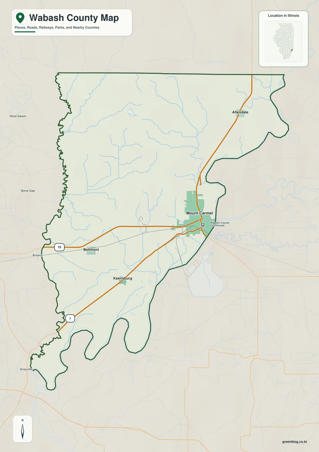
The county outline becomes especially unusual in the south. It narrows, bends, and widens again around the large river meanders, while the western edge is also irregular rather than a simple straight line. These bends make Wabash County look much longer and more complex than its small area might suggest. The general map is useful for keeping those boundary changes in view while comparing the locations of the four principal communities.
Mount Carmel contains the largest concentration of mapped streets and built-up land, but much of the county is more rural. North and west of the city, small streams and gently rolling terrain become more prominent than dense settlement. South of Keensburg, broad low areas and the river edge dominate the map. Moving from the county-and-road view to the water and elevation layers reveals how strongly those settlement differences are tied to the terrain.
Straight-line distance from Mount Carmel to three other communities
The city-connections map uses Mount Carmel as the hub and simplifies the county to four highlighted communities. The printed values are Mount Carmel 6,854, Allendale 499, Bellmont 196, and Keensburg 149. These figures are treated only as values printed on the supplied city map; they are not presented here as newly verified current population counts. The distance labels are also important because they show direct straight-line distance rather than driving distance.
Allendale is shown about 8 miles from Mount Carmel, Bellmont about 8 miles, and Keensburg about 7 miles in straight-line distance. The numbers are similar, but the directions are very different. Allendale is northeast, Bellmont west, and Keensburg southwest of the hub. That radial arrangement explains why no single road passes through all four communities in one simple line.
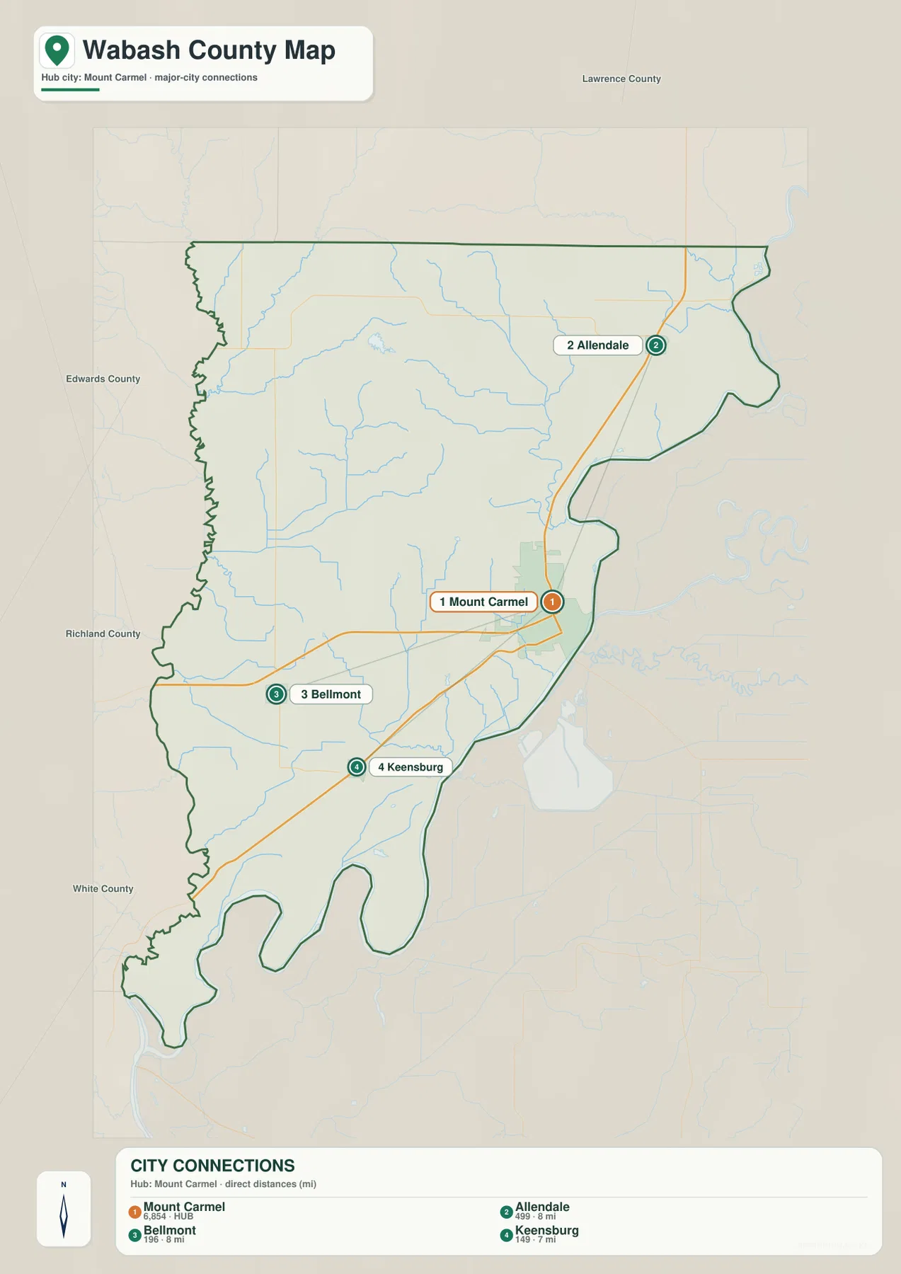
This is not a navigation map. Straight-line distance does not account for road curvature, intersections, bridges, or actual route choice, so driving distances can be longer. Its value is comparison: the map shows how close the three smaller communities are to Mount Carmel in direct distance while also making their different directions obvious. The general road map is better when the route itself matters.
Wabash River and the inland creeks divide the water landscape
The dominant water feature is the Wabash River along the eastern side of the county. It follows a large, winding course from the northeast toward the southern tip and helps form the county’s most irregular boundary. Inland from the river, the water map contains many smaller named creeks. Reading them by area is easier than trying to follow every blue line at once.
In the northwest, Big Branch and Little Bonpas Creek are prominent, with Jordan Creek extending toward Mesa Lake. Crawfish Creek forms another long drainage in the northern interior, and Raccoon Creek appears close to the northeastern edge. These northern waterways cut through some of the county’s higher terrain, creating narrow valleys between the ridges shown on the elevation map.
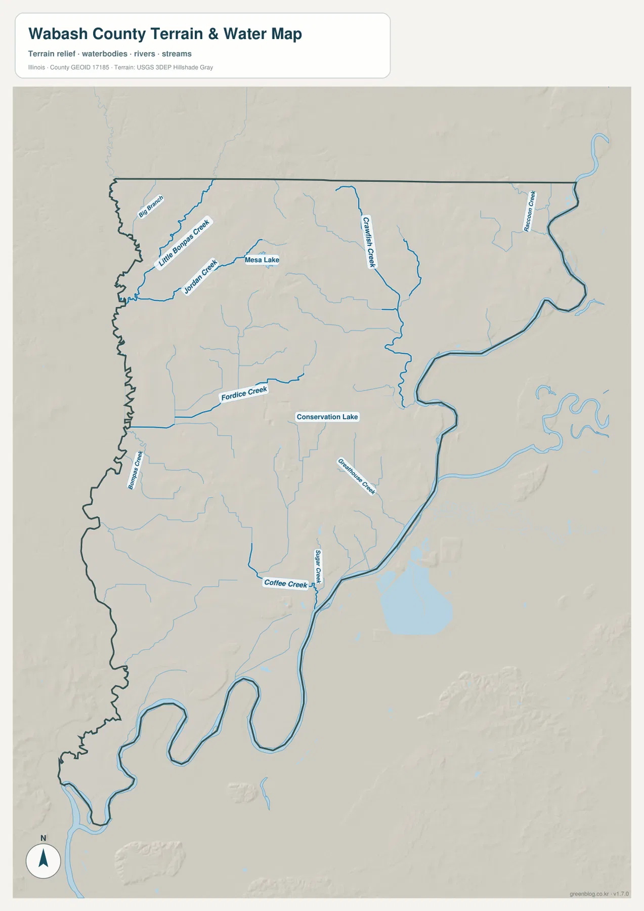
Fordice Creek is a clear west-central stream, with Conservation Lake labeled farther east. Greenhouse Creek descends through the east-central interior, while Coffee Creek and Sugar Creek meet the river side farther south. Near Keensburg, Illinois DNR identifies Beall Woods State Park along the Wabash River, and Coffee Creek runs through the Beall Woods reserve area. That local reference fits the water map’s strong concentration of river and creek features in the southeastern part of the county.
The terrain-and-water layer is intended for general geographic reference rather than flood-hazard, navigation, water-quality, parcel, or legal-boundary decisions. A mapped stream or lake shows relative location, not public access, navigability, or current flood conditions. Flood, water-use, and legal questions should be checked against the appropriate current official source.
110 to 179 meters separates river lowlands from northern hills
The supplied elevation layer reports an actual range of about 110 to 179 meters and a mean near 131 meters. The lowest dark-green terrain follows the Wabash River edge and spreads across much of the southern county. Higher tan and brown ground is concentrated across the northern and north-central interior, where several hill groups rise above the surrounding creek valleys.
The northern hills are not one continuous high surface. Little Bonpas Creek, Jordan Creek, Crawfish Creek, and smaller tributaries cut lower green corridors through them. The same pattern continues through the central county around Fordice Creek and Greenhouse Creek. Southward, the map becomes increasingly green, showing broader low terrain with only isolated higher ridges.
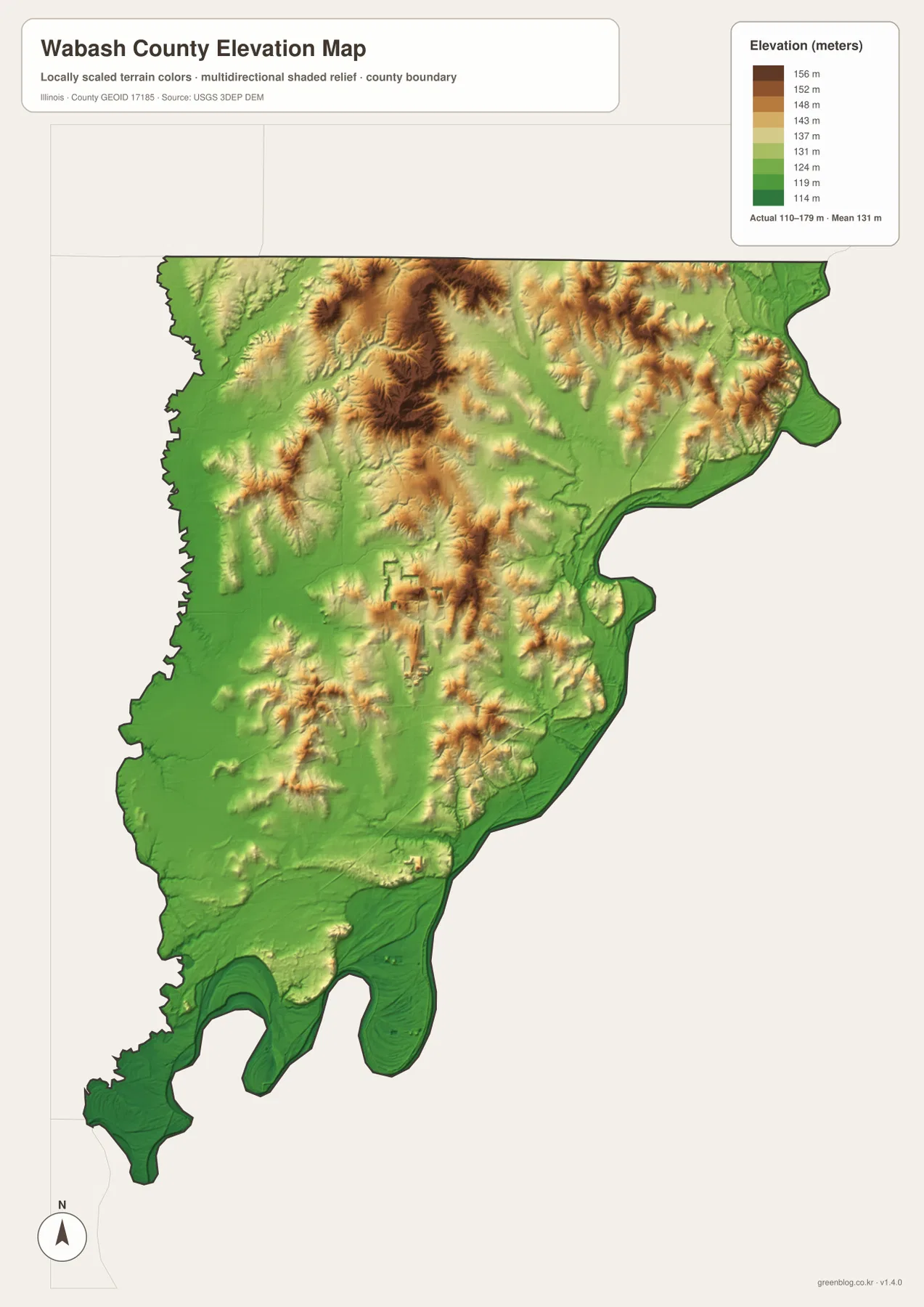
Mount Carmel lies close to the transition between the low river edge and the rolling interior. Around Allendale, the map also shows a strong contrast between the low eastern river corridor and higher ground a short distance inland. Bellmont sits among gentler western relief cut by small creek valleys, while the Keensburg side becomes generally lower toward the south. Wabash County is therefore better described as a river-lowland county with a distinctly hillier interior than as one uniformly flat surface.
The elevation surface is intended for county-scale comparison, not parcel surveying or engineering design. The 110–179 m range is useful for identifying river lowlands, creek valleys, and higher interior hills, but it does not provide survey-grade elevation for a specific property. Construction, drainage, flood, and legal decisions require more precise and current source data.
A practical order for using the Wabash County map set
For communities and roads, start with Mount Carmel and follow Route 15 toward Bellmont, then use Route 1 to orient the Keensburg side before moving northeast to Allendale. Use the city-connections map when the main question is how far the three smaller communities lie from Mount Carmel; remember that those values are straight-line distances. For water features, begin with Wabash River and then add Little Bonpas Creek, Crawfish Creek, Fordice Creek, Coffee Creek, and the smaller lakes. The elevation view is most useful after those waterways are familiar because it shows which valleys are low and where the higher interior hills rise.
The ZIP below contains four high-resolution JPG files matching the county-and-road map, city-connections map, terrain-and-water map, and elevation map on this page. Each image is 2572 × 3638 pixels in portrait orientation, making small road and stream labels easier to enlarge or print than in the browser-sized WebP versions. These maps are general reference products, so current traffic, legal parcel boundaries, flood determinations, water regulations, and survey-grade elevations should be checked against the appropriate official source.
Frequently Asked Questions
What distances are shown from Mount Carmel to Allendale, Bellmont, and Keensburg?
The city-connections map shows straight-line distance rather than driving distance. Allendale is about 8 miles from Mount Carmel, Bellmont about 8 miles, and Keensburg about 7 miles. Actual road travel can be longer because routes do not follow perfect straight lines.
Which map best shows Wabash River and the main interior creeks?
The terrain-and-water map is the clearest choice. It shows Wabash River along the eastern edge together with Little Bonpas Creek, Jordan Creek, Crawfish Creek, Fordice Creek, Coffee Creek, Sugar Creek, and several small lakes. It is intended for general geography rather than flood, navigation, or legal-water-boundary decisions.
Where are the higher and lower parts of Wabash County?
The supplied elevation layer shows the Wabash River edge and much of the southern county as lower green terrain, while higher tan and brown hills are concentrated in the north and north-central interior. The actual range is about 110 to 179 meters with a mean near 131 meters.
Map File Information
The ZIP contains high-resolution A3 JPG versions of the Wabash County road-and-boundary map, city-connections map, terrain-and-water map, and elevation map.
- Printable Size: 2572 × 3638 pixels each
- File Type: ZIP containing 4 JPG files
Related Maps
Sources and references
- Illinois State Archives – Wabash County local governments – county and Mount Carmel administrative reference
- Illinois Courts – Wabash County Courthouse – county courthouse reference in Mount Carmel
- Illinois DNR Beall Woods State Park – Wabash River and Coffee Creek natural-area reference
- U.S. Census Bureau TIGER/Line Shapefiles – county boundaries, roads, and place references
- USGS National Hydrography – rivers, streams, and lakes
- USGS 3D Elevation Program – elevation and terrain reference
Green Map creates custom-edited map images using open geographic data sources such as geoBoundaries, Natural Earth, OpenStreetMap, and government open data.
These maps are edited visual materials, not raw data files, and are provided for education, documents, presentations, and graphic reference.