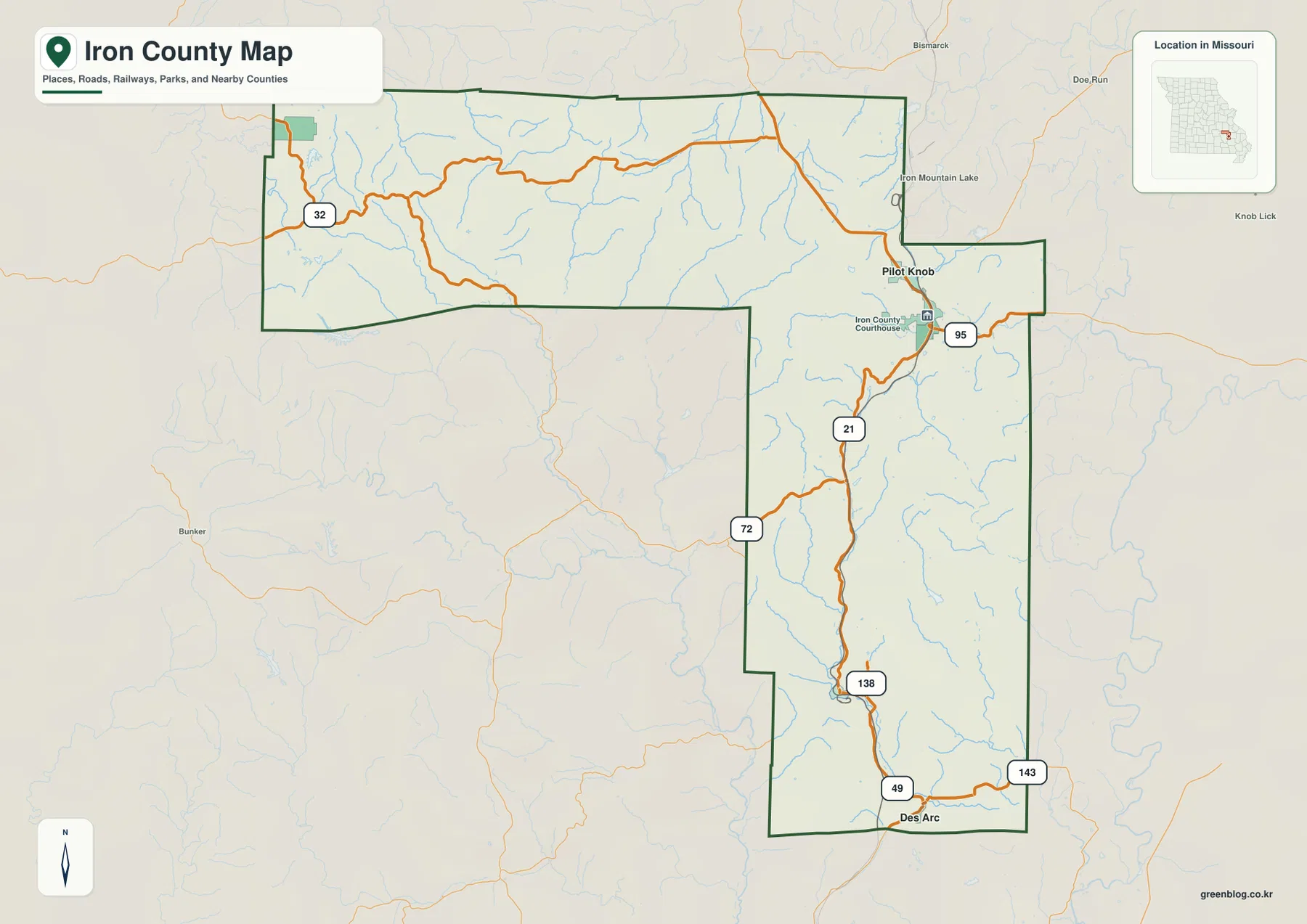
Iron County lies in southeastern Missouri, where the Arcadia Valley towns of Ironton, Pilot Knob, and Arcadia sit among the rugged St. Francois Mountains. The general map shows Routes 21, 72, 95, 32, 138, 49, and 143, while the terrain-and-water layer traces the Big River, St. Francis River, Big Creek, mountain streams, and several small lakes. The elevation map spans approximately 138 to 540 meters, an unusually large range for a Missouri county and one that reflects the presence of Taum Sauk Mountain, the state’s highest point. High-resolution JPG versions of the map themes are available together in the ZIP for printing or offline use. High-resolution map files are available for download in the section below.
A good way to read Iron County is to begin around Ironton and Pilot Knob, where several towns cluster within a narrow mountain valley, and then compare that area with Viburnum in the northwest and Annapolis and Des Arc in the south. Much of the county between those communities is steep, forested terrain cut by short streams and narrow valleys. The road map establishes the settlements, while the water and elevation layers explain why the county’s routes bend so sharply through the mountains.
Table of Contents
Ironton, Pilot Knob, and Arcadia share the Arcadia Valley
Ironton is the county seat and the clearest starting point on the general map. Pilot Knob lies immediately north, and Arcadia sits just to the south, creating a tight cluster of communities in the northeastern part of the county. Route 21 provides the main north-south road reference through the valley, while Routes 72 and 95 help organize the road network around Ironton and Pilot Knob.
Iron County’s official website describes Ironton, Pilot Knob, and Arcadia as communities within the Arcadia Valley, surrounded by the St. Francois Mountains of the Ozarks. That geography is obvious on the elevation map: the settled valley remains lower while steep ridges rise quickly around it. The county courthouse is also labeled in Ironton, connecting the map’s main town with the administrative center.
The city layer ranks six communities across a very uneven landscape
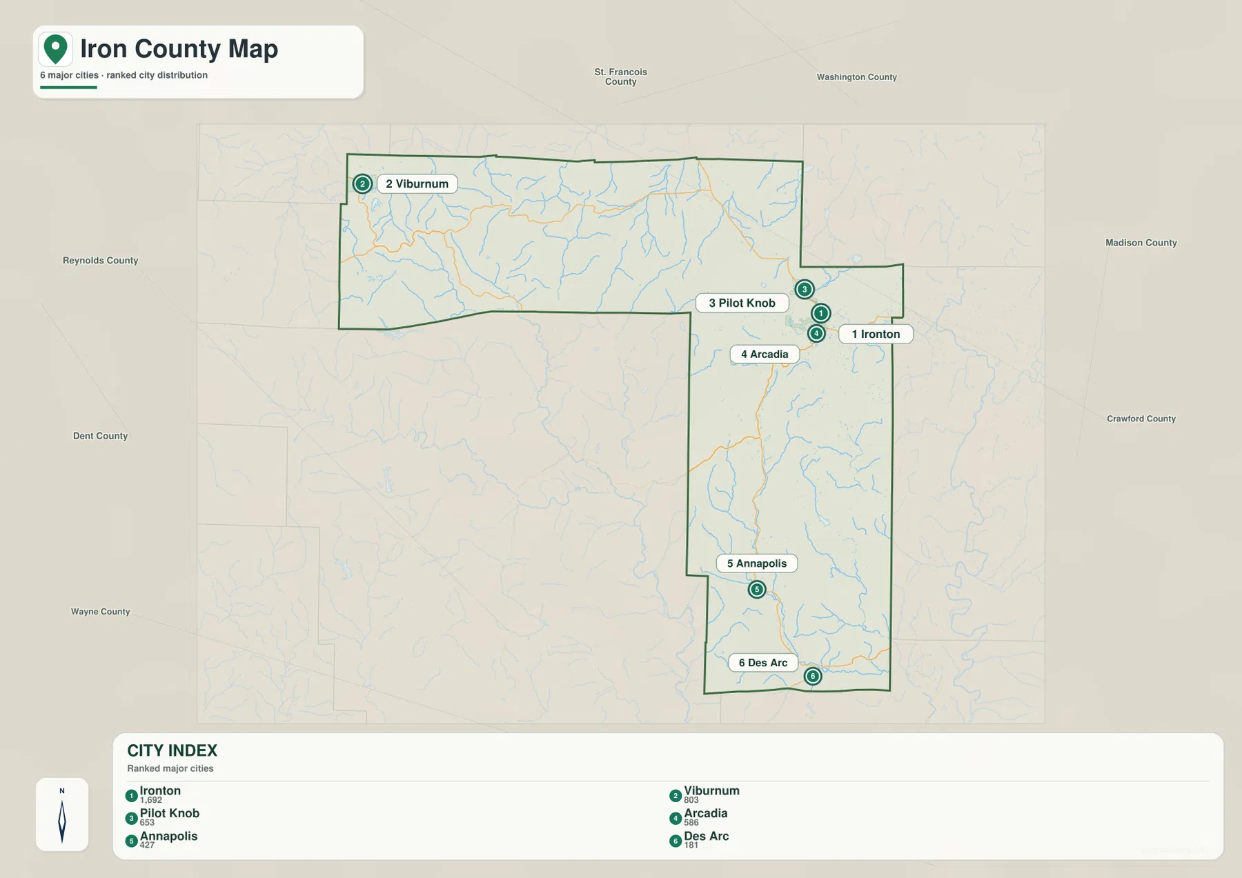
The ranked city map places Ironton first, Viburnum second, Pilot Knob third, Arcadia fourth, Annapolis fifth, and Des Arc sixth. The CITY INDEX lists values of 1,692 for Ironton, 803 for Viburnum, 653 for Pilot Knob, 586 for Arcadia, 427 for Annapolis, and 181 for Des Arc. These values belong to the map dataset and should not be treated as current official population estimates.
The spatial pattern matters more than the index values. Ironton, Pilot Knob, and Arcadia cluster tightly in the northeast, while Viburnum sits far to the northwest. Annapolis and Des Arc follow the county’s long southern section. The numbers indicate rank rather than mileage or travel time, and actual routes between these places must work around steep ridges and stream valleys.
Viburnum and Route 32 mark the northwestern mountain country
Viburnum lies near the northwestern edge of Iron County, with Route 32 providing the clearest east-west road reference. The area is much less urban than the Arcadia Valley and is crossed by the Big River and numerous small tributaries. Roads curve repeatedly through the hills rather than following long straight corridors.
The elevation map reinforces that impression. Western and northern Iron County contain broad tan and brown uplands separated by narrow green valleys. Comparing Viburnum with Ironton shows how settlement density changes within the same county: the valley towns are close together, while the western mountain country has larger gaps between communities.
Big River cuts a major valley through the western uplands
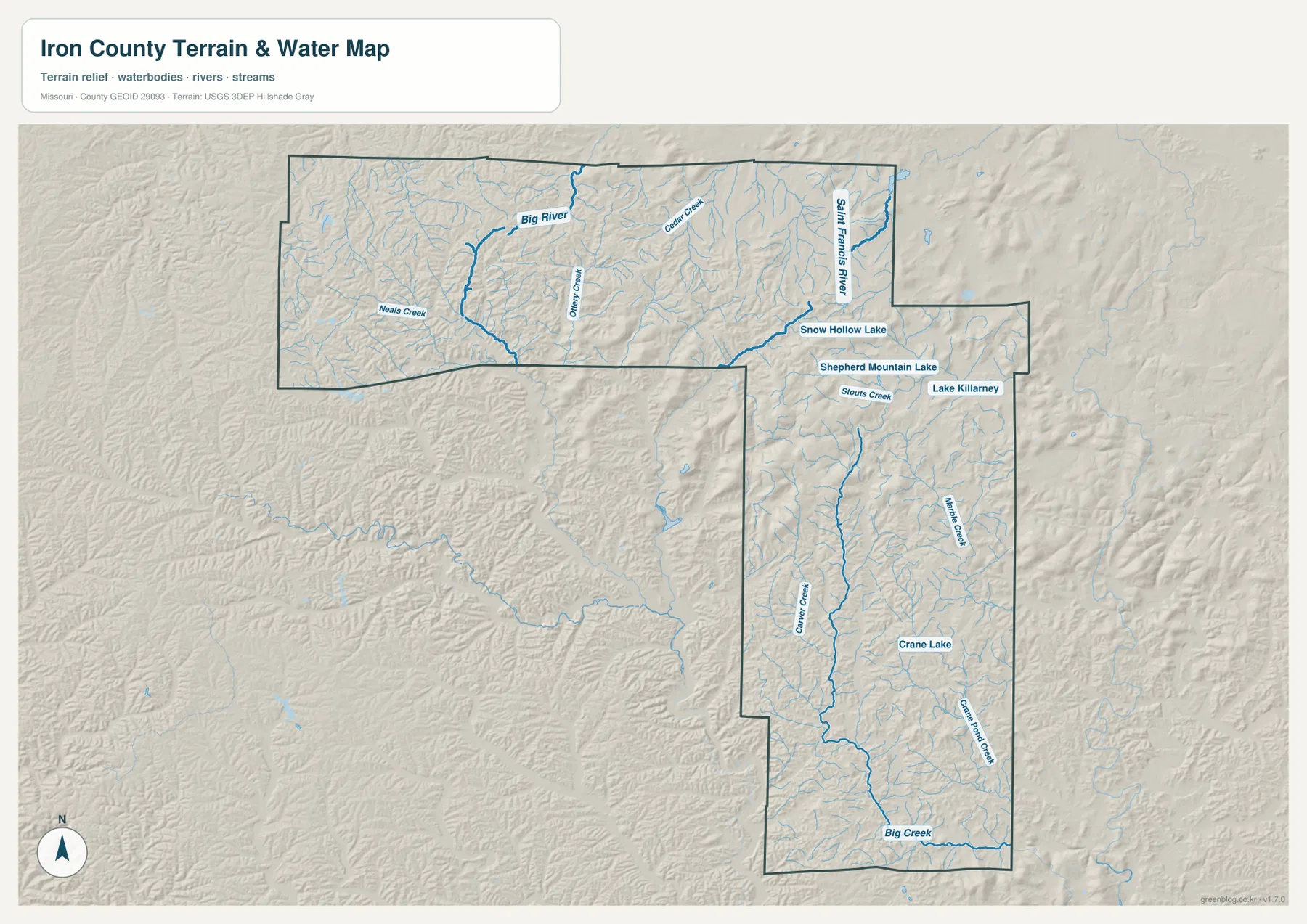
Big River is the most prominent watercourse in western Iron County. It winds through the northwestern portion of the county and receives tributaries such as Neals Creek from the surrounding highlands. On the elevation layer, the river follows a lower green corridor through much higher terrain.
Ottery Creek and Cedar Creek provide additional references farther east of the Big River corridor. These short mountain streams divide the uplands into many ridges, helping explain the irregular road network around Route 32. The water layer is especially useful here because a road-only view understates how deeply the landscape is cut by drainage valleys.
St. Francis River and the Arcadia Valley lakes define the northeast
St. Francis River appears near the northeastern side of the county. Around the Ironton and Pilot Knob area, the map also labels Snow Hollow Lake, Shepherd Mountain Lake, and Lake Killarney. These smaller water bodies do not dominate the county hydrology, but they provide useful local landmarks around the Arcadia Valley and the surrounding mountains.
Stouts Creek is labeled near the same region, adding another narrow drainage between the ridges. The Battle of Pilot Knob State Historic Site preserves Fort Davidson and the battlefield of the September 1864 Battle of Pilot Knob. Looking at the clustered towns and the steep surrounding terrain helps explain the confined setting in which that historic site sits.
Annapolis and Des Arc follow the long southern section
The southern part of Iron County narrows into a long north-south section. Route 21 and Route 138 are important road references there, with Annapolis near the middle and Des Arc close to the southern end. Coon Creek and Big Creek follow lower corridors through the hills, while Marble Creek and Crane Pond Creek appear farther east.
Crane Lake is labeled east of the Annapolis–Des Arc corridor. Unlike the compact Arcadia Valley cluster, southern settlements are more widely separated and aligned with stream valleys and the main road. The elevation map shows more extensive lower green terrain toward the south, although narrow ridges continue to divide the landscape.
Elevation ranges from about 138 to 540 meters
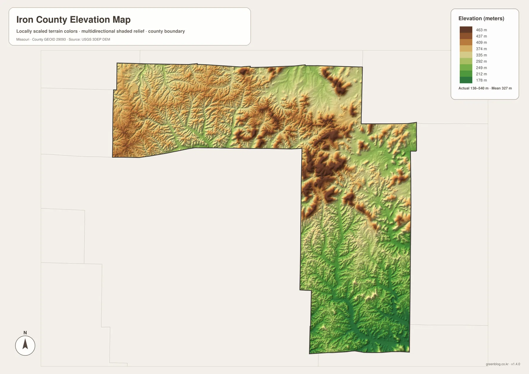
The elevation layer reports an actual mapped range of approximately 138 to 540 meters, with a mean near 327 meters. Brown and dark tan highlands dominate much of the north and center, while the major valleys and southern lowlands appear in green. The contrast is sharp enough that short distances can include major changes in relative elevation.
Missouri State Parks identifies Taum Sauk Mountain at 1,772 feet above sea level as the highest point in Missouri. That converts to roughly 540 meters, matching the maximum value on the supplied Iron County elevation map. Taum Sauk Mountain State Park sits within the St. Francois Mountains and represents the county’s rugged highland terrain at its most pronounced.
Elephant Rocks adds a distinctive granite landscape north of Pilot Knob
Elephant Rocks State Park provides a county-specific example of the geology behind the dramatic terrain. Missouri State Parks describes the site’s huge rounded boulders as approximately 1.5-billion-year-old granite. Missouri Department of Conservation identifies the natural area in Iron County and places it a few miles north of Pilot Knob along Highway 21.
The rocks form one of the most recognizable landscapes in southeastern Missouri, but they also fit the broader map story. The Arcadia Valley sits among ancient igneous mountains, and the high relief north and west of the valley is visible on the elevation layer. Locating Pilot Knob first makes it easier to place the Elephant Rocks area within the county.
Ironton remains the main reference for county government and services
Iron County’s official website lists the Iron County Courthouse at 250 S. Main Street in Ironton and provides access to the county commission, clerk, assessor, collector, court, sheriff, and other offices. That makes Ironton both the map’s leading city and the practical administrative reference.
University of Missouri Extension also maintains its Iron County office in Ironton at 123 W. Wayne Street, providing local agriculture, youth, and community resources. Current contacts and hours should be checked on the official pages, while the map is useful for understanding the office’s location within the Arcadia Valley.
Choosing the right downloadable map
Use the general county map when towns and highways are the priority. The ranked city layer is the quickest way to compare Ironton, Viburnum, Pilot Knob, Arcadia, Annapolis, and Des Arc. The terrain-and-water map is best for Big River, St. Francis River, Big Creek, mountain streams, and the Arcadia Valley lakes, while the elevation map shows the dramatic contrast between Taum Sauk-area highlands and lower southern valleys.
The ZIP contains high-resolution JPG versions of the same map themes shown on the page. They are useful for enlarging labels, printing a reference sheet, or comparing layers side by side. The files are intended for general geographic reference and do not replace live navigation, flood warnings, trail-status notices, legal boundary surveys, or professional elevation measurements.
Frequently Asked Questions
Where is the best place to start when reading the Iron County maps?
The Arcadia Valley cluster of Ironton, Pilot Knob, and Arcadia is the clearest starting point. The towns are close together, Route 21 passes through the valley, and steep St. Francois Mountain ridges rise immediately around them.
Do the numbers on the city map show distance?
No. They rank Ironton, Viburnum, Pilot Knob, Arcadia, Annapolis, and Des Arc within the supplied city dataset. The CITY INDEX values are not road mileage or travel times.
Why does the elevation map reach 540 meters?
Iron County contains Taum Sauk Mountain, which Missouri State Parks lists at 1,772 feet, or about 540 meters, above sea level. The supplied elevation map reaches the same approximate maximum.
Map File Information
Download the map files associated with this page for reference, printing, and compatible visual projects.
- Included Files: Use only the versions confirmed in the article and supplied images
- File Type: Use the confirmed download contents
- Intended Use: Printing, education, presentations, and map-based projects
Related Maps
Sources and references
- Iron County, Missouri – Official County Website – county government, Arcadia Valley, and regional information
- Missouri State Parks – Taum Sauk Mountain State Park – Missouri high point and St. Francois Mountain context
- Missouri State Parks – Elephant Rocks State Park – granite landscape north of Pilot Knob
- Battle of Pilot Knob State Historic Site – Fort Davidson and the 1864 battlefield at Pilot Knob
- U.S. Census Bureau TIGER/Line Shapefiles – county boundary and road data
- USGS National Hydrography – rivers, streams, and water features
- USGS 3D Elevation Program – elevation data
Green Map creates custom-edited map images using open geographic data sources such as geoBoundaries, Natural Earth, OpenStreetMap, and government open data. These maps are edited visual materials, not raw data files, and are provided for education, documents, presentations, and graphic reference.